 Block
From the record
One of 5 National Register listings published here for Benton County · listed in 1982 · category: Building.
Sources: the case file at the National Archives · the National Register database, National Park Service
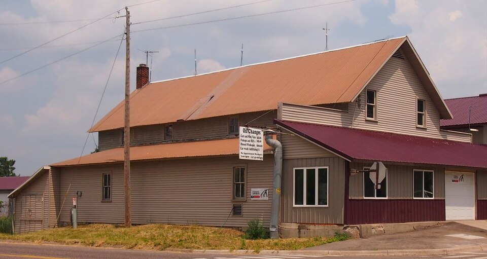
Listed on the National Register of Historic Places in 1982.
One of 5 National Register listings published here for Benton County · listed in 1982 · category: Building.
Sources: the case file at the National Archives · the National Register database, National Park Service
Regional context, not property-specific evidence. The federal wildfire occurrence database lists 130 fires within 5 miles of Esselman Brothers General Store between 1992 and 2020, burning about 415 acres in total. None started naturally. 18 were recorded as arson. Distance is straight-line from the map coordinates, so a fire counted here may appear on a neighbouring settlement's page as well.
| Reported cause | Fires |
|---|---|
| Debris and open burning | 59 |
| Arson/incendiarism | 18 |
| Equipment and vehicle use | 17 |
| Missing data/not specified/undetermined | 14 |
| Railroad operations and maintenance | 10 |
| Smoking | 5 |
| Recreation and ceremony | 5 |
| Misuse of fire by a minor | 2 |
The most recent of them, most recent first, with the day each was reported and the service that recorded it.
| Date | Cause | Size | Reported by | Name on the report |
|---|---|---|---|---|
| 25 September 2003 | Arson/incendiarism | 1.1 acres | Minnesota Department of Natural Resources | not named |
| 24 September 1992 | Debris and open burning | 60 acres | Minnesota Department of Natural Resources | not named |
| 21 September 2012 | Debris and open burning | under an acre | Minnesota Department of Natural Resources | not named |
| 2 September 2003 | Missing data/not specified/undetermined | under an acre | Minnesota Department of Natural Resources | not named |
| 15 September 1998 | Railroad operations and maintenance | under an acre | Minnesota Department of Natural Resources | not named |
| 31 August 2003 | Equipment and vehicle use | under an acre | Minnesota Department of Natural Resources | not named |
| 31 August 2003 | Arson/incendiarism | under an acre | Minnesota Department of Natural Resources | not named |
| 22 August 2013 | Equipment and vehicle use | under an acre | Minnesota Department of Natural Resources | not named |
Regional context, not property-specific evidence. The federal mineral resources record lists 1 working within 5 miles of Esselman Brothers General Store: 1 occurrence. None of them still produces. What was taken out: Limestone, General. Distance is straight-line from the map coordinates, so a quarry counted here may appear on a neighbouring settlement's page as well.
| Where | Site | Commodity | Status | Recorded |
|---|---|---|---|---|
| Benton County Marl Bed | Limestone, General | Occurrence |
Regional context, not property-specific evidence. The National Weather Service names Rice, the town this property stands in, in 25 storm reports between 1995 and 2025: 16 hail, 7 thunderstorm wind, 1 funnel cloud, 1 lightning. The reports record 1 injury. Each account below is quoted exactly as the forecast office filed it, from the NOAA Storm Events Database, and each date opens the federal record of that event.
| When | Event | Place named | Harm | What the report says |
|---|---|---|---|---|
| August 2010 | Thunderstorm Wind | Rice | 1 hurt, $50,000 | Many hundreds, perhaps thousands of trees were uprooted, snapped or broken in an eight mile wide swath that extended from the western edge of the county, near Rice to Watab, to just north of Sartell, to north central Benton County, in Graham Township, centered near State Highway 25 and County Road 77. In addition, a local Minnesota Department of Transportation Weather Station near Rice, measured a wind gust of 64 knots. A semi-truck was blown over near Rice along Highway 10, resulting in one injury. Plus, a spotter on the northeast shore of Little Rock Lake measured a wind gust of 81 mph before his tower collapsed and the anemometer ceased to function. The intense wind blew from the southwest. Hundreds of large and healthy trees were broken or snapped, blocking roads. The storm survey team concluded a downburst hit the area. |
| June 2015 | Lightning | Rice | $5,000 | Local officials determined that lightning started a fire, and also damaged a gas meter in Rice, Minnesota. The damage was limited mostly to the exterior of the house. |
| June 2025 | Thunderstorm Wind | Rice | - | Mesonet station MN064 T.h.10 - Rice - Mp 162 measured a thunderstorm wind gust of 60 mph. |
| September 2019 | Thunderstorm Wind | Rice | - | A Minnesota Department of Transportation wind sensor measured a wind gust of 65 mph. |
| March 2017 | Hail | Rice | - | A swath of large hail, up to quarter size, fell near Rice, and northeast of Rice to the Morrison County line. Almost all of the hail was dime size or smaller. |
| June 2009 | Hail | Rice | - | Local Law Enforcement officials and the Emergency Manager reported a nearly continuous path of large hail that fell across northern Benton County from near Rice, northeast to Brennyville. This path is the extension of the hail swath across northern Stearns County. Most of the hail was nickel to quarter size and had depths over 6 inches in some places. The largest hail stone was around tennis ball size. |
| July 2008 | Thunderstorm Wind | Rice | - | Wind gust occurred on US Highway 10 Mile post 162. |
| June 2007 | Hail | Rice | - | Some crop damage was reported. |
| June 2005 | Funnel Cloud | Rice | - | A trained spotter reported a funnel cloud. |
| July 2002 | Thunderstorm Wind | Rice | - | Scattered trees down. |
| July 1999 | Thunderstorm Wind | Rice | - | Large branches down. Estimated windspeed. |
| May 2022 | Thunderstorm Wind | Rice | - | no account filed |
| June 2012 | Hail | Rice | - | no account filed |
| July 2011 | Hail | Rice | - | no account filed |
| May 2008 | Hail | Rice | - | no account filed |
| August 2007 | Hail | Rice | - | no account filed |
| July 2003 | Hail | Rice | - | no account filed |
| July 2002 | Hail | Rice | - | no account filed |
| July 1999 | Hail | Rice | - | no account filed |
| July 1999 | Hail | Rice | - | no account filed |
| July 1999 | Hail | Rice | - | no account filed |
| May 1998 | Hail | Rice | - | no account filed |
| May 1998 | Hail | Rice | - | no account filed |
| June 1997 | Hail | Rice | - | no account filed |
| July 1995 | Hail | Rice | - | no account filed |
No historic map-sheet match is published for this property yet. That does not mean no map exists. This record needs a coordinate-quality review before it can be joined to a sheet boundary. Browse the county's mapped places while that work is pending.
| National Archives record | The nomination case file for reference 82002933 in Record Group 79. |
| Benton County | All 5 listed properties in this county. |