
BlockBefore
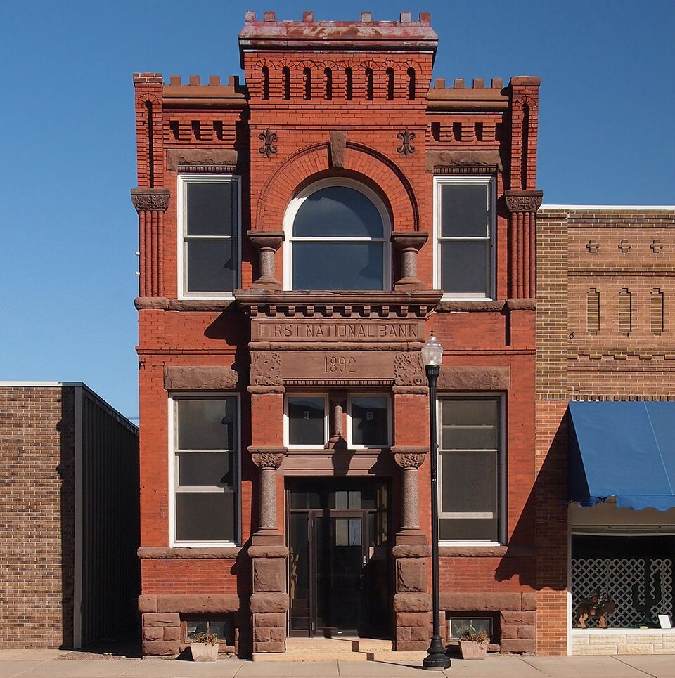
Photograph of Commercial Bank Building
Photograph by McGhiever, CC BY-SA 3.0. Via Wikimedia Commons.

Commercial Bank Building

Built in 1892. Listed on the National Register of Historic Places in 1982.

From the record

“The Dawson Bank Museum is a museum operating inside of the former First National Bank Building in Dawson, Minnesota. The building is listed on the National Register of Historic Places.”

Wikipedia article Dawson Bank Museum, CC BY-SA 4.0.

One of 9 National Register listings published here for Lac qui Parle County · listed in 1982 · category: Building · built in 1892.

Sources: the Wikipedia article · the case file at the National Archives · the National Register database, National Park Service · the Wikipedia article

The listing

  • What is counted as historic. The nomination lists 1 building as contributing to the listing.
  • Address. Off US 212, Dawson, 56232
  • When was it listed? January 1982
  • Category. building
  • Township. Riverside township
  • When was it built? 1892
  • National Register reference number. 82002978 - the number the National Park Service assigned this property when it was listed, and the key its nomination file is catalogued under at the National Archives.

Storms near this property

42 since 1996

Regional context, not property-specific evidence. The National Weather Service names Dawson, the town this property stands in, in 42 storm reports between 1996 and 2022: 24 hail, 16 thunderstorm wind, 1 tornado, 1 flood. No death or injury is recorded in these reports. Each account below is quoted exactly as the forecast office filed it, from the NOAA Storm Events Database, and each date opens the federal record of that event.

WhenEvent Place namedHarm What the report says
March 2007FloodDawson$425,000Spring snow melt with rapid warming brought ice jams and flooding to portions of West Central Minnesota. On the 14th, Lac Qui Parle county officials reported flooded township roads west of the intersection of roads 212 and 75 (along the West Fork of the Lac Qui Parle River). The ice jam responsible for the flooding was west of the city of Dawson. The Dawson Sentinel reported plenty of damage to the Helgeson Bridge southeast of Dawson. Three quarters of the bridge was toppled.
May 2022Thunderstorm WindDawson$250,000Severe winds destroyed a machine shop north of Dawson.
May 2022Thunderstorm WindDawson-A metal shed was destroyed and several trees were broken.
May 2022Thunderstorm WindDawson-Roof covering was partially removed from a house, part of the the top of a grain bin was blown away, dozens of trees were broken, and part of a large metal shed lost its roof and walls.
June 2017Thunderstorm WindDawson-Numerous trees and power lines blown were blown down near Dawson.
July 2016Thunderstorm WindDawson-Several large trees were uprooted or snapped above ground level near Dawson.
June 2015Thunderstorm WindDawson-Several large tree branches were blown down in Dawson.
July 2011HailDawson-In addition to the hail, some crop damage was reported from the Emergency Manager.
July 2008Thunderstorm WindDawson-Many large trees toppled across town, along with large branches. Several large trees also reported downed across local roads. Several automobiles also reported blown into ditches.
September 2007HailDawson-Houses and vehicles sustained damage.
April 2006HailDawson-Hail covered the ground.
July 2006Tornado (F0)Dawson-A grove of trees was damaged in the tornado's path, along with a few shingles and planks that were torn off a barn, including a small amount of siding ripped off a house. The tornado was accompanied by large hail, very heavy rain, and damaging rear flank downdraft wind.
July 2006Thunderstorm WindDawson-Rear flank downdraft adjacent to the tornado downed numerous large trees and caused minor building damage.
May 2005HailDawson-A deputy sheriff reported quarter sized hail.
June 2005Thunderstorm WindDawson-A large tree was downed along Chestnut Street.
June 2002Thunderstorm WindDawson-Path up to 1 mile wide. Crop Damage. Large trees down. Power lines down.
June 2002Thunderstorm WindDawson-Trees down.
June 2001Thunderstorm WindDawson-Large tree branches down.
July 1999Thunderstorm WindDawson-Few trees down. Estimated windspeed.
July 1999Thunderstorm WindDawson-Numerous trees down. Corn flattened. Estimated windspeed.
July 1999Thunderstorm WindDawson-Trees, power lines down. Winds estimated.
May 1998HailDawson-Many cars damaged at automobile lots. Roof, siding and shed damage.
July 1997HailDawson-Large tree also sheared in half due to strong winds.
July 1997Thunderstorm WindDawson-Tree damage.
May 2022HailDawson-no account filed
June 2016HailDawson-no account filed
May 2014HailDawson-no account filed
June 2012HailDawson-no account filed
July 2008HailDawson-no account filed
September 2005HailDawson-no account filed
April 2002HailDawson-no account filed
June 2002HailDawson-no account filed
August 2002HailDawson-no account filed
September 1999HailDawson-no account filed
May 1998HailDawson-no account filed
October 1996HailDawson-no account filed

Every storm recorded in Lac qui Parle County

Map coverage status

No historic map-sheet match is published for this property yet. That does not mean no map exists. This record needs a coordinate-quality review before it can be joined to a sheet boundary. Browse the county's mapped places while that work is pending.

Listed places nearby

2 within 8 miles

Other National Register properties close enough to walk or drive between, ordered by distance from this one. Both positions come from the same geocoding pass that matched these properties to their map sheets.

Photograph PropertyDistance Listed
Dawson Armory and Community Buildingunder 500 feet1995
Dawson Carnegie Libraryunder 500 feet1985

Sources for this property

National Archives recordThe nomination case file for reference 82002978 in Record Group 79.
Wikipedia articleCommunity-written account of this property, licensed CC BY-SA.
Lac qui Parle CountyAll 9 listed properties in this county.

Provenance

  • Listing record. National Park Service National Register of Historic Places, listed-properties dataset, current to 2026-05-22.
  • Map join. Address geocoded through the United States Census geocoder, then tested against the published boundary of every sheet in the USGS Historical Topographic Map Collection.
  • How this page is made. Listing fields come from federal records; map-sheet coverage is a labelled coordinate-to-boundary calculation, not a source-field claim.
  • Storms. NOAA National Centers for Environmental Information, Storm Events Database https://www.ncei.noaa.gov/stormevents/ A work of the United States government, no copyright under 17 U.S.C. 105. Narratives are quoted verbatim from the National Weather Service report and are not edited or summarised.