 Block
From the record
One of 7 National Register listings published here for McLeod County · listed in 1982 · category: Building.
Sources: the case file at the National Archives · the National Register database, National Park Service
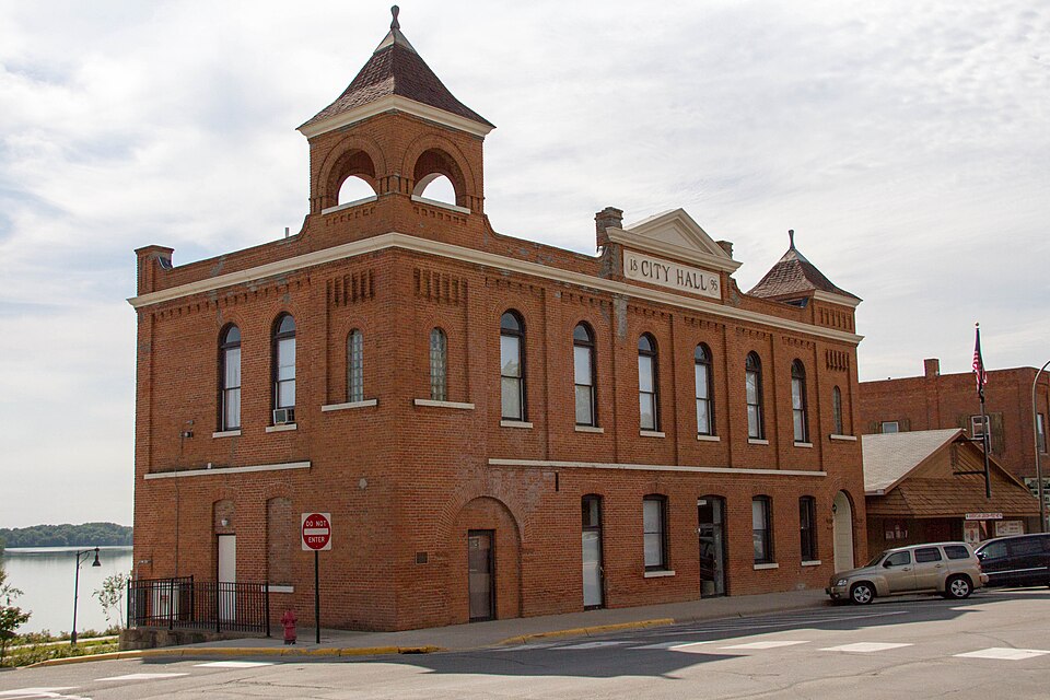
Listed on the National Register of Historic Places in 1982.
One of 7 National Register listings published here for McLeod County · listed in 1982 · category: Building.
Sources: the case file at the National Archives · the National Register database, National Park Service
Regional context, not property-specific evidence. The federal wildfire occurrence database lists 1 fire within 5 miles of Winsted City Hall in 2011, burning about 3 acres in total. None started naturally. None was recorded as arson. Distance is straight-line from the map coordinates, so a fire counted here may appear on a neighbouring settlement's page as well.
| Reported cause | Fires |
|---|---|
| Missing data/not specified/undetermined | 1 |
The most recent of them, most recent first, with the day each was reported and the service that recorded it.
| Date | Cause | Size | Reported by | Name on the report |
|---|---|---|---|---|
| 9 November 2011 | Missing data/not specified/undetermined | 3.0 acres | Minnesota Department of Natural Resources | not named |
Regional context, not property-specific evidence. The National Weather Service names Winsted, the town this property stands in, in 51 storm reports between 1994 and 2025: 27 hail, 16 thunderstorm wind, 3 flash flood, 2 funnel cloud. No death or injury is recorded in these reports. Each account below is quoted exactly as the forecast office filed it, from the NOAA Storm Events Database, and each date opens the federal record of that event.
| When | Event | Place named | Harm | What the report says |
|---|---|---|---|---|
| June 2002 | Thunderstorm Wind | Winsted | $20,000 | Roof blown off mobile home at airport. Roof blown off stage at Winstock Music Festival, destroying numerous folding chairs. |
| June 2013 | Flash Flood | Winsted | $15,000 | Significant street flooding occurred in the town of Winsted as rainfall amounts were in excess of 1 to 2 inches in a short period of time. Some homes reported basement flooding. |
| May 2012 | Thunderstorm Wind | Winsted | $10,000 | Several large tree branches caused damage to power lines around the city. |
| July 2010 | Lightning | Winsted | $5,000 | Lightning struck a home and it caught on fire. |
| July 2025 | Thunderstorm Wind | Winsted | - | Report of a tree down on house. |
| June 2023 | Thunderstorm Wind | Winsted | - | This event is a continuation of the strong thunderstorm that developed into Wright County and traveled into far northeastern McLeod County. Emergency Management reported numerous large limbs and two trees that were brought down by strong wind gusts and blocked roads in Winsted. |
| July 2016 | Thunderstorm Wind | Winsted | - | Several large tree branches were blown down across the city of Winsted. One large tree, 20 inches in diameter, also fell in Winsted on 6th Street. |
| July 2016 | Tornado (EF0) | Winsted | - | Multiple photos and videos showed a funnel cloud east of Winsted, and that it was very close to the ground. Damage was verified at the same location, with several trees knocked down and heavy farm machinery moved. |
| July 2016 | Hail | Winsted | - | A picture was taken of several large hail stones, the largest was three inches in diameter in northeast Winsted. |
| August 2016 | Thunderstorm Wind | Winsted | - | Several large tree limbs were blown down across Winsted. |
| July 2016 | Funnel Cloud | Winsted | - | A funnel cloud was observed east of Winsted. Although multiple photos and videos showed the funnel close to the ground, it was not possible to verify that it touched down. |
| June 2013 | Flash Flood | Winsted | - | Flood waters were flowing over roads, north of Winsted. |
| June 2013 | Thunderstorm Wind | Winsted | - | A few trees and power lines were blown down in Winsted. |
| June 2013 | Thunderstorm Wind | Winsted | - | A tree was blown down across a power line. |
| May 2012 | Thunderstorm Wind | Winsted | - | A large tree was blown down. |
| August 2011 | Heavy Rain | Winsted | - | Minor ponding of water was reported at the intersection of Fairlawn Avenue and Fairlawn Circle in Winsted. |
| June 2005 | Thunderstorm Wind | Winsted | - | A pole barn and other large sheds were downed just south of Winsted along County Road 1. Numerous trees and a few power lines were downed onto homes, vehicles, and roads in Winsted. A wall was pushed in the downtown area. |
| April 2004 | Thunderstorm Wind | Winsted | - | Three sheds, a barn, and several trees were downed. |
| April 2004 | Thunderstorm Wind | Winsted | - | A carport was blown off a building near the intersection of Route 15 and Highway 7. |
| June 2002 | Flash Flood | Winsted | - | Basements were flooded and roads covered in the wake of a quick three to four inches of rain. |
| July 1999 | Thunderstorm Wind | Winsted | - | Estimated winds, trees felled. |
| June 1998 | Hail | Winsted | - | Large branches down with some crop damage. |
| July 1997 | Thunderstorm Wind | Winsted | - | Trees and power lines down. Estimated windspeed. |
| July 1997 | Thunderstorm Wind | Winsted | - | Tree damage. |
| May 2022 | Hail | Winsted | - | no account filed |
| April 2021 | Hail | Winsted | - | no account filed |
| July 2016 | Hail | Winsted | - | no account filed |
| June 2013 | Hail | Winsted | - | no account filed |
| June 2013 | Hail | Winsted | - | no account filed |
| June 2013 | Hail | Winsted | - | no account filed |
| June 2013 | Hail | Winsted | - | no account filed |
| April 2012 | Hail | Winsted | - | no account filed |
| May 2011 | Hail | Winsted | - | no account filed |
| July 2008 | Hail | Winsted | - | no account filed |
| July 2008 | Hail | Winsted | - | no account filed |
| July 2008 | Hail | Winsted | - | no account filed |
| July 2008 | Hail | Winsted | - | no account filed |
| July 2008 | Hail | Winsted | - | no account filed |
| August 2007 | Hail | Winsted | - | no account filed |
| August 2007 | Hail | Winsted | - | no account filed |
| June 2007 | Hail | Winsted | - | no account filed |
| August 2006 | Hail | Winsted | - | no account filed |
| September 2005 | Hail | Winsted | - | no account filed |
| August 2004 | Hail | Winsted | - | no account filed |
| April 2002 | Hail | Winsted | - | no account filed |
| June 2002 | Hail | Winsted | - | no account filed |
| June 2001 | Hail | Winsted | - | no account filed |
| July 2000 | Hail | Winsted | - | no account filed |
| July 2000 | Funnel Cloud | Winsted | - | no account filed |
| May 1998 | Thunderstorm Wind | Winsted | - | no account filed |
| June 1994 | Hail | Winsted | - | no account filed |
No historic map-sheet match is published for this property yet. That does not mean no map exists. This record needs a coordinate-quality review before it can be joined to a sheet boundary. Browse the county's mapped places while that work is pending.
| National Archives record | The nomination case file for reference 82002988 in Record Group 79. |
| McLeod County | All 7 listed properties in this county. |