 Block
From the record
One of 9 National Register listings published here for Lac qui Parle County · listed in 1986 · category: Building.
Sources: the case file at the National Archives · the National Register database, National Park Service
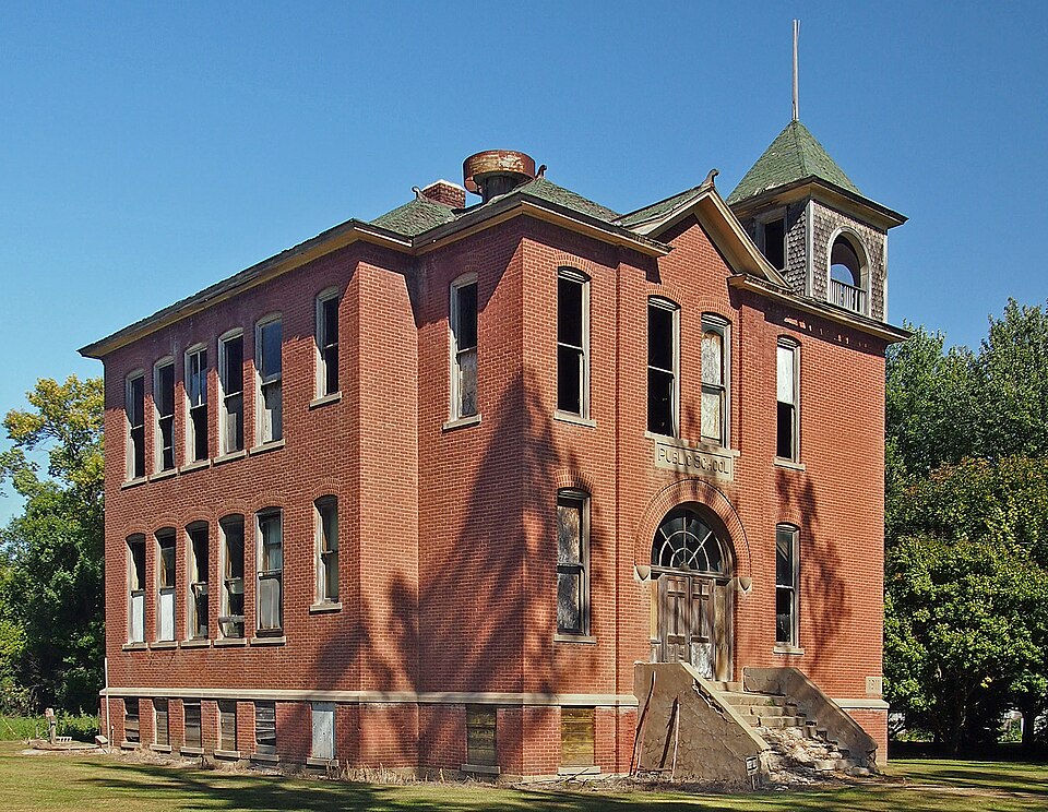
Listed on the National Register of Historic Places in 1986.
One of 9 National Register listings published here for Lac qui Parle County · listed in 1986 · category: Building.
Sources: the case file at the National Archives · the National Register database, National Park Service
Regional context, not property-specific evidence. The federal wildfire occurrence database lists 3 fires within 5 miles of Louisburg School between 2004 and 2007, burning about 7,524 acres in total. 1 started naturally. 1 was recorded as arson. Distance is straight-line from the map coordinates, so a fire counted here may appear on a neighbouring settlement's page as well.
| Reported cause | Fires |
|---|---|
| Natural | 1 |
| Other causes | 1 |
| Arson/incendiarism | 1 |
The most recent of them, most recent first, with the day each was reported and the service that recorded it.
| Date | Cause | Size | Reported by | Name on the report |
|---|---|---|---|---|
| 14 May 2007 | Other causes | 43 acres | Morris National Wildlife Refuge | UNNAMED |
| 13 May 2007 | Natural | 150 acres | Minnesota Department of Natural Resources | SECTION 32 |
| 14 April 2004 | Arson/incendiarism | 7,330 acres | Minnesota Department of Natural Resources | LOUISBURGRADE |
Regional context, not property-specific evidence. The National Weather Service names Louisburg, the town this property stands in, in 22 storm reports between 1997 and 2025: 12 hail, 5 thunderstorm wind, 3 tornado, 1 lightning. No death or injury is recorded in these reports. Each account below is quoted exactly as the forecast office filed it, from the NOAA Storm Events Database, and each date opens the federal record of that event.
| When | Event | Place named | Harm | What the report says |
|---|---|---|---|---|
| August 2010 | Tornado (EF0) | Louisburg | $100,000 | Local law enforcement officials, spotters and chasers observed a brief tornado touchdown on the southern edge of Louisburg. It picked up a grain bin at the Louisburg elevator and threw it 100 yards. Some trees were also uprooted near the same area. |
| August 2011 | Thunderstorm Wind | Louisburg | $3,500 | Power lines were blown down near Louisburg, Minnesota. |
| July 2025 | Funnel Cloud | Louisburg | - | A brief tornado was reported by somebody with a fire department, but there were no photos provided nor any reports of damage. Satellite imagery did not show any path or damage, and nobody else spotted a tornado. With the uncertainty, this was most likely a funnel cloud. |
| May 2023 | Tornado (EFU) | Louisburg | - | A weak tornado develop north of Madison in Lac Qui Parle county. There were several images of this tornado on social media, but no reports of damage. |
| May 2022 | Tornado (EF1) | Louisburg | - | Damage was convergent, with peak winds estimated near 105 mph. A house received significant damage, with much of its roof removed. Numerous trees were broken. |
| June 2015 | Thunderstorm Wind | Louisburg | - | The local emergency manager received damage reports in areas east of Highway 75, and north of Highway 40 as a severe storm moved through. The following are some of the reports received: one hog barn destroyed, 13 power poles broken, 3 grain bins damaged, one hoop barn damaged, one machine shed damaged, one 5th wheel livestock trailer destroyed, numerous windows broken, and house siding damaged. |
| June 2015 | Hail | Louisburg | - | A swath of large hail, the largest being ping pong ball size, occurred in an area between the Lac Qui Parle, and Big Stone County line, southeast toward the town of Cerro Gordo. The combination of hail and wind caused considerable damage to the row crops in this area as well as substantial building/property damage. It was also indicated that an estimated 10,600 acres of soybeans were likely destroyed and another 10,600 acres were damaged. |
| July 2012 | Hail | Louisburg | - | The combination of large hail and wind gusts up to 50 mph, caused significant crop damage across the northern fringe of Lac Qui Parle County. |
| August 2009 | Hail | Louisburg | - | The local law enforcement officials reported dime to quarter size hail which covered the ground. The next morning the local emergency manager reported that the hail remained in the city of Louisburg, Minnesota with drifts still around two feet. Some residences of Lac Qui Parle County reported that the hail lasted for one half hour with drifts of two to three feet. Minor damage occurred to crops and local gardens. |
| June 2007 | Hail | Louisburg | - | Leaves stripped off of several trees. |
| June 2007 | Hail | Louisburg | - | Dime to nickel size hail covered the ground. |
| August 2006 | Thunderstorm Wind | Louisburg | - | Trees, baseball dug outs blown over near High School. Tree felled over CR66. |
| June 2004 | Thunderstorm Wind | Louisburg | - | Two grain bins were damaged. A shed and a tree were downed. |
| June 2004 | Hail | Louisburg | - | Field crops were destroyed by wind driven hail. |
| June 2001 | Thunderstorm Wind | Louisburg | - | A few trees down, empty rail car moved. |
| July 1997 | Lightning | Louisburg | - | Fire caused by lightning strike to tree spread to small shed and tractor. |
| June 2024 | Hail | Louisburg | - | no account filed |
| May 2012 | Hail | Louisburg | - | no account filed |
| June 2007 | Hail | Louisburg | - | no account filed |
| July 2006 | Hail | Louisburg | - | no account filed |
| June 2004 | Hail | Louisburg | - | no account filed |
| July 2000 | Hail | Louisburg | - | no account filed |
No historic map-sheet match is published for this property yet. That does not mean no map exists. This record needs a coordinate-quality review before it can be joined to a sheet boundary. Browse the county's mapped places while that work is pending.
| National Archives record | The nomination case file for reference 86001348 in Record Group 79. |
| Lac qui Parle County | All 9 listed properties in this county. |