
BlockBefore
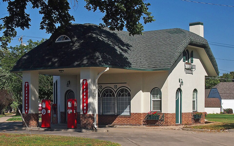
Photograph of Lundring Service Station
Photograph by McGhiever, CC BY-SA 3.0. Via Wikimedia Commons.

Lundring Service Station

Built in 1926. Listed on the National Register of Historic Places in 1986.

From the record

“The Lundring Service Station is a historic former gas station in Canby, Minnesota, United States. It was built in 1926 in the style of an English cottage.”

Wikipedia article Lundring Service Station, CC BY-SA 4.0.

One of 5 National Register listings published here for Yellow Medicine County · listed in 1986 · category: Building · built in 1926.

Sources: the Wikipedia article · the case file at the National Archives · the National Register database, National Park Service

The listing

  • What is counted as historic. The nomination lists 1 building as contributing to the listing.
  • Address. 201 First St. E, Canby, 56220
  • When was it listed? June 1986
  • Category. building
  • City. Canby city
  • When was it built? 1926
  • National Register reference number. 86001356 - the number the National Park Service assigned this property when it was listed, and the key its nomination file is catalogued under at the National Archives.

Fires near this property

1 since 2012

Regional context, not property-specific evidence. The federal wildfire occurrence database lists 1 fire within 5 miles of Lundring Service Station in 2012, burning about 1 acre in total. None started naturally. None was recorded as arson. Distance is straight-line from the map coordinates, so a fire counted here may appear on a neighbouring settlement's page as well.

Reported cause Fires
Smoking1

The most recent of them, most recent first, with the day each was reported and the service that recorded it.

DateCause SizeReported by Name on the report
3 October 2012Smoking1.0 acresMinnesota Department of Natural Resourcesnot named

Every fire recorded in Yellow Medicine County

Mines and quarries near this property

1 within 5 miles

Regional context, not property-specific evidence. The federal mineral resources record lists 1 working within 5 miles of Lundring Service Station: 1 producer. All of them still produce. What was taken out: Sand and Gravel, Construction. Distance is straight-line from the map coordinates, so a quarry counted here may appear on a neighbouring settlement's page as well.

Where SiteCommodity StatusRecorded
D and C Gravel Pit and MillSand and Gravel, ConstructionProducer

Every working recorded in Yellow Medicine County

Storms near this property

33 since 1994

Regional context, not property-specific evidence. The National Weather Service names Canby, the town this property stands in, in 33 storm reports between 1994 and 2024: 16 hail, 12 thunderstorm wind, 4 tornado, 1 funnel cloud. No death or injury is recorded in these reports. Each account below is quoted exactly as the forecast office filed it, from the NOAA Storm Events Database, and each date opens the federal record of that event.

WhenEvent Place namedHarm What the report says
August 2015Tornado (EF1)Canby$500,000A tornado moved across several farmsteads, destroying several outbuildings, uprooting or breaking hundreds of trees, and damaging crops. About seven hay bales (each with a diameter of six feet) were blown apart for about 1/4 mile downwind. The damage pattern suggested this was a multiple vortex tornado. The tornado was accompanied by a damaging rear flank downdraft just to the south of the tornado.
May 2022Thunderstorm WindCanby$250,000In addition to the Canby Airport severe wind gust, two structures had significant damage in Canby. One house had its roof torn off north of Canby, and a church in Canby had its tin roof blown off.
August 2015Thunderstorm WindCanby$100,000Strong rear flank downdraft winds accompanied a tornado. The winds tipped over two silos that landed on top of a barn about 4 miles south of Canby. The winds also toppled dozens of trees. Even after the tornado dissipated, strong winds continued eastward into the city of Porter, with occasional tree and crop damage along the way.
May 2024Funnel CloudCanby-A funnel cloud was photographed near Canby. Other funnel clouds may have occurred in the area, but additional information was not provided.
May 2021Tornado (EF0)Canby-A storm chaser took photos of a landspout tornado. It was mostly over an open field, but did knock down large branches of a few trees. Part of the circulation moved across a tractor being driven by a local farmer, but the vehicle remained upright. The time was based on the chaser's phone and compared with radar.
June 2007HailCanby-Hail covered the driveway of residence.
July 2006Thunderstorm WindCanby-Wind gust measured at the Canby Airport. The gust resulted from a Heat Burst caused by decaying thunderstorms and a very warm and dry lower and middle atmosphere. In addition to the wind gust, the temperature jumped from 91 degrees to 100 degrees between 10:35 PM and 11:15 PM. The dew point temperature also dropped from 63 degrees to 32 degrees between 1035 PM and 1115 PM.
June 2005Thunderstorm WindCanby-Law enforcement officers reported downed trees.
June 2005Thunderstorm WindCanby-Trees and branches were downed. A few business signs were damaged and a large piece of tin roofing material was thrown approximately 50 yards.
August 2004Thunderstorm WindCanby-Trees were downed and a wagon was tossed into a pasture on a farm in Fortier Township.
July 2000Tornado (F0)Canby-No damage, touchdown in open field.
July 1999Thunderstorm WindCanby-Numerous 6 inch diameter branches down. Estimated windspeed.
June 1999HailCanby-Hail punched holes in plexiglass porch sunroof.
June 1998Thunderstorm WindCanby-Trees and power lines down. Estimated windspeed.
May 1998Thunderstorm WindCanby-Trees and powerlines blown down. Barns destroyed. Minor damage to high school. Grain bin also blown down in Porter. Estimated windspeed.
June 1997Thunderstorm WindCanby-Trees down.
October 1997HailCanby-Hail damage included roof of bus garage, elementary school windows and a school vehicle.
August 1995Thunderstorm WindCanby-There was some roof damage.
July 1994HailCanby-A tornado touched down briefly near Canby damaging some buildings on a farmstead and downing several trees.
July 1994Tornado (F0)Canby-A tornado touched down briefly near Canby damaging some buildings on a farmstead and downing several trees.
June 2015HailCanby-no account filed
July 2006HailCanby-no account filed
June 2006HailCanby-no account filed
April 2004HailCanby-no account filed
June 2004HailCanby-no account filed
April 2002HailCanby-no account filed
June 1999HailCanby-no account filed
May 1996HailCanby-no account filed
July 1994HailCanby-no account filed
July 1994Thunderstorm WindCanby-no account filed
July 1994HailCanby-no account filed

Every storm recorded in Yellow Medicine County

Map coverage status

No historic map-sheet match is published for this property yet. That does not mean no map exists. This record needs a coordinate-quality review before it can be joined to a sheet boundary. Browse the county's mapped places while that work is pending.

Listed places nearby

2 within 8 miles

Other National Register properties close enough to walk or drive between, ordered by distance from this one. Both positions come from the same geocoding pass that matched these properties to their map sheets.

Photograph PropertyDistance Listed
Canby Commercial Historic District0.1 miles1980
John G. Lund House0.3 miles1978

Sources for this property

National Archives recordThe nomination case file for reference 86001356 in Record Group 79.
Wikipedia articleCommunity-written account of this property, licensed CC BY-SA.
Yellow Medicine CountyAll 5 listed properties in this county.

Provenance

  • Listing record. National Park Service National Register of Historic Places, listed-properties dataset, current to 2026-05-22.
  • Map join. Address geocoded through the United States Census geocoder, then tested against the published boundary of every sheet in the USGS Historical Topographic Map Collection.
  • How this page is made. Listing fields come from federal records; map-sheet coverage is a labelled coordinate-to-boundary calculation, not a source-field claim.
  • Wildfire. Short, Karen C. 2022. Spatial wildfire occurrence data for the United States, 1992-2020 [FPA_FOD_20221014]. 6th Edition. Fort Collins, CO: Forest Service Research Data Archive. https://doi.org/10.2737/RDS-2013-0009.6 Collected with United States Government funding and usable without additional permissions or fees.
  • Mines and quarries. USGS Mineral Resources Data System (MRDS) https://mrdata.usgs.gov/mrds/ A work of the United States government, no copyright under 17 U.S.C. 105.
  • Storms. NOAA National Centers for Environmental Information, Storm Events Database https://www.ncei.noaa.gov/stormevents/ A work of the United States government, no copyright under 17 U.S.C. 105. Narratives are quoted verbatim from the National Weather Service report and are not edited or summarised.