 Block
From the record
3 National Register listings published here.
Sources: the National Register database, National Park Service
58 topographic sheets cover 24 settlements here, and 3 properties are on the National Register of Historic Places.
3 National Register listings published here.
Sources: the National Register database, National Park Service
Every property in this county listed on the National Register of Historic Places, with the year it was listed and the federal nomination document.
| Photograph | Property | Type | Listed | Reference |
|---|---|---|---|---|
 | Andrew County Courthouse | building | 1980 | 80002308 |
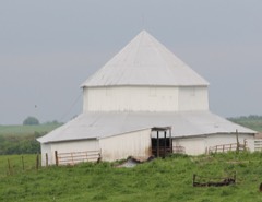 | J.F. Roberts Octagonal Barn | building | 1999 | 99001362 |
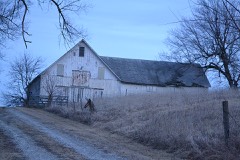 | Walnut Park Farm Historic District | district | 1999 | 99001597 |
Every wildfire the federal occurrence database records inside this county: 55 of them, burning about 461 acres. None started naturally and none was recorded as arson. Each settlement page carries the fires within five miles of it.
| Reported cause | Fires |
|---|---|
| Missing data/not specified/undetermined | 37 |
| Debris and open burning | 11 |
| Equipment and vehicle use | 5 |
| Other causes | 2 |
The five largest, by the area the report gives. None of them was recorded as arson.
| Date | Cause | Size | Reported by | Name on the report |
|---|---|---|---|---|
| 18 April 2018 | Missing data/not specified/undetermined | 140 acres | Missouri Department of Conservation | 176704-00201-04182018-0310 |
| 22 March 2018 | Missing data/not specified/undetermined | 95 acres | Missouri Department of Conservation | 176702-00201-03222018-2120 |
| 27 February 2018 | Equipment and vehicle use | 53 acres | Missouri Department of Conservation | 176447-00202-02272018-1247 |
| 14 April 2018 | Missing data/not specified/undetermined | 20 acres | Missouri Department of Conservation | 177978-00205-04142018-1205 |
| 22 February 2020 | Missing data/not specified/undetermined | 15 acres | Missouri Department of Conservation | 230829-00203-02222020-1550 |
| 8 March 2020 | Missing data/not specified/undetermined | 13 acres | Missouri Department of Conservation | 190464-00205-03082020-0215 |
| 16 November 2016 | Missing data/not specified/undetermined | 10 acres | Missouri Department of Conservation | 142073-00202-11162016-0612 |
| 6 October 1999 | Debris and open burning | 10 acres | Missouri Department of Conservation | not named |
Every settlement page carries the fires within five miles of it - see the settlement index below.
The NOAA Storm Events Database holds 267 reports for this county, causing 1 death, 16 injuries and about $6,934,840 in recorded property damage. Each settlement page carries the reports that name it.
| Kind of event | Reports |
|---|---|
| Hail | 114 |
| Thunderstorm Wind | 104 |
| Tornado | 24 |
| Flash Flood | 15 |
| Flood | 10 |
The most serious of them, by death, then injury, then recorded damage. The accounts are quoted exactly as the forecast office filed them.
| When | Event | Place named | Harm | What the report says |
|---|---|---|---|---|
| June 1994 | Tornado (F2) | Whitesville | 1 killed, 2 hurt, $5,000,000 | A tornado touched down southeast of Whitesville destroying 12 mobile homes. A 58-year old woman was killed and her husband injured in one of the mobile homes, which had been tied down. Another occupant sustained minor injuries after fleeing the home to seek shelter in a nearby pickup truck. The storm also damaged a workshop and buildings on a nearby farm with total damage estimates around $950,000. (F58M) |
| March 2006 | Tornado (F2) | Fillmore | 8 hurt, $800,000 | Tornado touched down southeast of Fillmore and traveled northeast 5 miles before dissipating around Highway 71 and A Highway. Three homes were nearly or completely destroyed and 8 had minor to moderate damage. Eight persons were injured. |
| September 1959 | Tornado (F1) | not stated | 3 hurt, $2,500 | no account filed |
| April 1999 | Tornado (F1) | Fillmore | 2 hurt, $500,000 | The tornado touched down northwest of Fillmore and moved rapidly northeast...destroying 6 homes from 3 miles NW of Fillmore to the intersection of Highways Y and H. Near this intersection, a grain bin was heavily damaged and an empty semi trailer truck was blown into a pond. Numerous trees and power lines were downed along the path. Tree damage clearly denoted the path length and width along the track. An eyewitness near the intersection of Y and H highways witnessed the tornado formation and rushed to one of the damaged homes. Thew two minor injuries were to residents of two mobile homes damaged 3 miles NW of Fillmore. |
| July 1962 | Tornado (F1) | not stated | 1 hurt, $25,000 | no account filed |
| March 2019 | Flood | Amazonia | $100,000 | Once the Missouri River started flooding on March 9, it remained in flood through the remainder of the month. The gauges in Rulo, Brownville, and St. Joseph all hit preliminary records as a result of this flooding. The flooding was caused by several rounds of heavy snow across the Northern Plains through the winter months, followed by a rapid warm-up and several days of heavy rain. The Missouri River Basin across the Northern Plains flooded with catastrophic consequences as numerous dams and levees failed. As the water flowed into the Missouri River upstream of Andrew County, the river swelled and ultimately overwhelmed the levees along the river. Local fields were submerged, which delayed the growing season in the region. I-29 from St. Joseph northward to the Iowa/Missouri border was closed until mid May. Note: The dollar valued assigned to this event is likely inaccurate as a full tally of the extent of the physical damages is unknown. The Missouri River remained in flood through the rest of the month, into April. |
| June 2015 | Thunderstorm Wind | Savannah | $50,000 | Estimated 4 to 50 power poles snapped between Amazonia, Savannah, and Rosendale. Multiple trees were uprooted and broken in Savannah. |
| June 1994 | Hail | Bolckow | $50,000 | Golf ball-size hail broke windows and damage roofs. Strong wind also downed large trees. |
| June 1994 | Thunderstorm Wind | Savannah | $50,000 | Power lines and poles were blown down. |
| September 1993 | Hail | Rosendale | $50,000 | Softball-size hail damaged numerous roofs and automobiles. |
| September 1993 | Thunderstorm Wind | Helena | $50,000 | A grain drier was blown over. |
| July 1997 | Thunderstorm Wind | Bolckow | $25,000 | A Northeast Andrew County citizen reported damage to a large farm storage building from severe thunderstorms winds. The same storm also knocked over 2 large trees. A severe weather spotter in Rochester reported wind gusts to 55 MPH. |
| April 1995 | Thunderstorm Wind | Savannah | $25,000 | Dime-size hail fell with strong thunderstorms from the Savannah area north to Rosendale. Thunderstorm winds also knocked down several large tree limbs northwest of Savannah. |
| April 1991 | Tornado (F1) | not stated | $25,000 | no account filed |
| December 1972 | Tornado (F1) | not stated | $25,000 | no account filed |
| July 1962 | Tornado (F1) | not stated | $25,000 | no account filed |
| June 1960 | Tornado (F1) | not stated | $25,000 | no account filed |
| May 1959 | Tornado (F1) | not stated | $25,000 | no account filed |
| August 2015 | Thunderstorm Wind | Bolckow | $10,000 | Trees were down in Bolckow near Ann Street with some of the tree damage down on a car. |
| July 2004 | Flash Flood | Savannah | $10,000 | Several roads washed out due to heavy rains. |
| July 2001 | Thunderstorm Wind | Fillmore | $10,000 | 2 foot diameter tree blown over crushing truck. |
| May 2011 | Tornado (EF0) | Fillmore | $7,000 | At 1830CST, an EF0 tornado touched down nearly 4 miles southeast of Fillmore. The tornado moved around a mile northeast, before lifting at 1833CST, about 4 miles east of Fillmore. Minor damage was reported to three homes. Tree damage was also reported. |
| June 2008 | Thunderstorm Wind | Fillmore | $5,000 | High winds destroyed a barn and shed. |
| June 1994 | Thunderstorm Wind | Rea | $5,000 | Several large trees were blown down in Rea with one falling through the roof of a house. Large trees were also blown down between Rosendale and Savannah. |
| September 1993 | Hail | Union Star | $5,000 | no account filed |
| May 2007 | Flood | Bolckow | $4,000 | The 102 River at Rosendale had its second highest crest ever on May 7, 2007. It crested at 23.50 feet, or 5.50 feet above flood stage. Nearly every home in the town suffered flood damage. |
| July 1995 | Tornado | Route D | $3,000 | Severe thunderstorms produced golf ball-size hail and downed trees near Cosby. Tornadoes touched down along Route D and over Country Club Village. Near Savanah a lumbar yard was destroyed. |
| July 1995 | Hail | not stated | $3,000 | Severe thunderstorms produced golf ball-size hail and downed trees near Cosby. Tornadoes touched down along Route D and over Country Club Village. Near Savanah a lumbar yard was destroyed. |
| April 1991 | Tornado (F1) | not stated | $2,500 | no account filed |
| April 1961 | Tornado (F0) | not stated | $2,500 | no account filed |
| September 1959 | Tornado (F1) | not stated | $2,500 | no account filed |
| June 1995 | Thunderstorm Wind | Rosendale | $2,000 | Severe thunderstorms produced wind gusts up to 60 mph at Rosendale. Numerous trees were knocked down. |
| July 1995 | Thunderstorm Wind | Fillmore | $2,000 | Numerous trees and power line were reported down over Western Andrew County. |
| June 2019 | Thunderstorm Wind | Avenue City | $1,000 | A power pole was broken at CR 304 and HWY 169. |
| June 2011 | Thunderstorm Wind | Savannah | $1,000 | Trees and power lines were reported down. Thunderstorm wind gusts were estimated up to 60 mph. |
| May 2011 | Thunderstorm Wind | Bolckow | $1,000 | A power pole was blown over at Highway 71 and Route Y. Thunderstorm wind gusts were estimated up to 70 mph. |
| August 2010 | Thunderstorm Wind | Savannah | $1,000 | A powerpole was blown over on County Road 33. Thunderstorm wind gusts were estimated up to 60 mph. |
| August 2010 | Thunderstorm Wind | Lone Corner | $1,000 | A metal machine shed roof was blown off. Several trees were blown over. An outbuilding was also destroyed and grass was flattened by the microburst. |
| August 2007 | Thunderstorm Wind | Savannah | $1,000 | Powerlines down. |
| March 2002 | Thunderstorm Wind | Savannah | $1,000 | Power lines and trees reported down. |
| May 2016 | Thunderstorm Wind | Helena | $500 | Tree limbs were down in the neighbor's yard. The largest was 2 feet in diameter. |
| December 2008 | Thunderstorm Wind | Amazonia | $500 | Thunderstorm winds ripped a porch off a house on Route 398 near the Missouri River. |
| June 1994 | Thunderstorm Wind | Savannah | $500 | Several large trees were blown down in Rea with one falling through the roof of a house. Large trees were also blown down between Rosendale and Savannah. |
| June 1957 | Tornado (F1) | not stated | $250 | no account filed |
| April 1981 | Tornado (F0) | not stated | $30 | no account filed |
| May 1962 | Tornado (F0) | not stated | $30 | no account filed |
| May 1962 | Tornado (F0) | not stated | $30 | no account filed |
| May 2025 | Thunderstorm Wind | Amazonia | - | Downed wires and power outages near Amazonia. |
| April 2025 | Thunderstorm Wind | Savannah | - | Downed wires near Business U.S. Highway 71 near 15th Terrace. |
| April 2025 | Thunderstorm Wind | Savannah | - | Downed wires and power outages near Route E. |
| April 2025 | Hail | Fillmore | - | Quarter sized hail reported in Fillmore. |
| March 2025 | Thunderstorm Wind | Helena | - | Social media report of damage to a barn roof and to a chicken coop near Helena. |
| March 2025 | Thunderstorm Wind | Avenue City | - | Downed wires and power outages near County Line Road. |
| August 2025 | Thunderstorm Wind | Fillmore | - | Private weather sensor recorded 52 knot wind gust near Fillmore. |
| June 2025 | Thunderstorm Wind | Amazonia | - | Multiple reports of downed tree limbs and wires near County Line Road. |
| June 2025 | Thunderstorm Wind | Rochester | - | Reports of downed limbs and wires near Happy Holler Lake Conservation Area. |
| June 2025 | Thunderstorm Wind | Helena | - | Downed wires near Route V. |
| June 2024 | Thunderstorm Wind | Fillmore | - | Estimated gusts up to 60 mph in Fillmore with tree limbs downed. |
| June 2024 | Thunderstorm Wind | Savannah | - | Downed trees reported in Savannah from a second round of storms about 50 minutes after the initial round that also brought tree limbs down. |
| May 2024 | Thunderstorm Wind | Rosendale | - | Emergency Management reported sporadic wind damage from Rosendale north to the county line. |
The Survey's mineral resources record lists 70 workings inside this county. 6 still produce and 64 are closed or unrecorded. Each settlement page carries the workings within five miles of it.
| Commodity | Workings |
|---|---|
| Stone, Crushed/Broken | 60 |
| Sand and Gravel, Construction | 10 |
The least common of them first, because a county's hundredth gravel pit says nothing its first ten did not.
| Where | Site | Commodity | Status | Recorded |
|---|---|---|---|---|
| Ed Denny Quarry | Sand and Gravel, Construction | Past Producer | ||
| Unk | Sand and Gravel, Construction | Past Producer | ||
| Unk | Sand and Gravel, Construction | Past Producer | ||
| Unk | Sand and Gravel, Construction | Past Producer | ||
| Unk | Sand and Gravel, Construction | Past Producer | ||
| Unk | Sand and Gravel, Construction | Past Producer | ||
| Unk | Sand and Gravel, Construction | Past Producer | ||
| Unk | Sand and Gravel, Construction | Past Producer | ||
| Unk | Sand and Gravel, Construction | Past Producer | ||
| Unk | Sand and Gravel, Construction | Past Producer | ||
| Amazonia Quarry | Stone, Crushed/Broken | Producer | ||
| Avenue City Quarry | Stone, Crushed/Broken | Past Producer | ||
| Breit Quarry and Mill | Stone, Crushed/Broken | Producer | ||
| Burrie Quarry and Mill | Stone, Crushed/Broken | Producer | ||
| Everett Quarries #51 | Stone, Crushed/Broken | Prospect | ||
| Flag Spring Quarry | Stone, Crushed/Broken | Producer | ||
| H.M.Denny Quarry | Stone, Crushed/Broken | Prospect | ||
| Knorr Quarry | Stone, Crushed/Broken | Producer | ||
| Lance Quarry | Stone, Crushed/Broken | Past Producer | ||
| Riverview Quarry | Stone, Crushed/Broken | Producer | ||
| Schuster Quarry | Stone, Crushed/Broken | Past Producer | ||
| Stewart Quarry | Stone, Crushed/Broken | Past Producer | ||
| Unk | Stone, Crushed/Broken | Past Producer | ||
| Unk | Stone, Crushed/Broken | Past Producer | ||
| Unk | Stone, Crushed/Broken | Past Producer | ||
| Unk | Stone, Crushed/Broken | Past Producer | ||
| Unk | Stone, Crushed/Broken | Past Producer | ||
| Unk | Stone, Crushed/Broken | Past Producer | ||
| Unk | Stone, Crushed/Broken | Past Producer | ||
| Unk | Stone, Crushed/Broken | Past Producer | ||
| Unk | Stone, Crushed/Broken | Past Producer | ||
| Unk | Stone, Crushed/Broken | Past Producer | ||
| Unk | Stone, Crushed/Broken | Past Producer | ||
| Unk | Stone, Crushed/Broken | Past Producer | ||
| Unk | Stone, Crushed/Broken | Past Producer | ||
| Unk | Stone, Crushed/Broken | Past Producer | ||
| Unk | Stone, Crushed/Broken | Past Producer | ||
| Unk | Stone, Crushed/Broken | Past Producer | ||
| Unk | Stone, Crushed/Broken | Past Producer | ||
| Unk | Stone, Crushed/Broken | Past Producer | ||
| Unk | Stone, Crushed/Broken | Past Producer | ||
| Unk | Stone, Crushed/Broken | Past Producer | ||
| Unk | Stone, Crushed/Broken | Past Producer | ||
| Unk | Stone, Crushed/Broken | Past Producer | ||
| Unk | Stone, Crushed/Broken | Past Producer | ||
| Unk | Stone, Crushed/Broken | Past Producer | ||
| Unk | Stone, Crushed/Broken | Past Producer | ||
| Unk | Stone, Crushed/Broken | Past Producer | ||
| Unk | Stone, Crushed/Broken | Past Producer | ||
| Unk | Stone, Crushed/Broken | Past Producer | ||
| Unk | Stone, Crushed/Broken | Past Producer | ||
| Unk | Stone, Crushed/Broken | Past Producer | ||
| Unk | Stone, Crushed/Broken | Past Producer | ||
| Unk | Stone, Crushed/Broken | Past Producer | ||
| Unk | Stone, Crushed/Broken | Past Producer | ||
| Unk | Stone, Crushed/Broken | Past Producer | ||
| Unk | Stone, Crushed/Broken | Past Producer | ||
| Unk | Stone, Crushed/Broken | Past Producer | ||
| Unk | Stone, Crushed/Broken | Past Producer | ||
| Unk | Stone, Crushed/Broken | Past Producer | ||
| Unk | Stone, Crushed/Broken | Past Producer | ||
| Unk | Stone, Crushed/Broken | Past Producer | ||
| Unk | Stone, Crushed/Broken | Past Producer | ||
| Unk | Stone, Crushed/Broken | Past Producer | ||
| Unk | Stone, Crushed/Broken | Past Producer | ||
| Unk | Stone, Crushed/Broken | Past Producer | ||
| Unk | Stone, Crushed/Broken | Past Producer | ||
| Unk | Stone, Crushed/Broken | Past Producer | ||
| Unk | Stone, Crushed/Broken | Past Producer | ||
| Unk | Stone, Crushed/Broken | Past Producer |
Named settlements recorded in the Geographic Names Information System, each with the topographic sheets covering it. Villages, hamlets and abandoned places alike. Each is shown with the nearest named watercourse or landform and the survey quadrangle it falls on.
Monroe township · 64505 · On Long Branch · Saint Joseph North quadrangle
22 sheets, 1924 to 1997
Jefferson township · 64505 · Saint Joseph North quadrangle
22 sheets, 1924 to 1997
Jefferson township · 64485 · On Crowley Creek · Saint Joseph North quadrangle
22 sheets, 1924 to 1997
Empire township · 64494 · On Crooked Creek · Whitesville quadrangle
13 sheets, 1925 to 1986
Benton township · 64483 · On Lower Neely Branch · Bolckow quadrangle
12 sheets, 1927 to 1986
Platte township · 64480 · On Agee Creek · Whitesville quadrangle
13 sheets, 1925 to 1986
The vanished settlements of Andrew County: the places named above that are no longer on the map.