 Block
From the record
1 National Register listing published here.
Sources: the National Register database, National Park Service
69 topographic sheets cover 25 settlements here, and 1 property is on the National Register of Historic Places.
1 National Register listing published here.
Sources: the National Register database, National Park Service
Every property in this county listed on the National Register of Historic Places, with the year it was listed and the federal nomination document.
| Photograph | Property | Type | Listed | Reference |
|---|---|---|---|---|
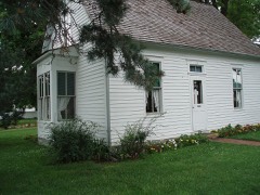 | Harry Truman Birthplace Memorial | building | 1969 | 69000089 |
Every wildfire the federal occurrence database records inside this county: 99 of them, burning about 2,349 acres. None started naturally and 8 were recorded as arson. Each settlement page carries the fires within five miles of it.
| Reported cause | Fires |
|---|---|
| Debris and open burning | 48 |
| Missing data/not specified/undetermined | 23 |
| Equipment and vehicle use | 12 |
| Arson/incendiarism | 8 |
| Smoking | 3 |
| Railroad operations and maintenance | 3 |
| Recreation and ceremony | 1 |
| Power generation/transmission/distribution | 1 |
The five largest, by the area the report gives. One of them was set deliberately.
| Date | Cause | Size | Reported by | Name on the report |
|---|---|---|---|---|
| 20 November 1993 | Debris and open burning | 260 acres | Missouri Department of Conservation | not named |
| 4 March 2017 | Debris and open burning | 200 acres | Missouri Department of Conservation | not named |
| 13 January 1994 | Missing data/not specified/undetermined | 160 acres | Missouri Department of Conservation | not named |
| 18 May 1994 | Debris and open burning | 160 acres | Missouri Department of Conservation | not named |
| 18 March 2018 | Debris and open burning | 120 acres | Missouri Department of Conservation | 176111-00625-03182018-1454 |
| 5 July 2000 | Debris and open burning | 100 acres | Missouri Department of Conservation | not named |
| 19 January 2015 | Equipment and vehicle use | 100 acres | Missouri Department of Conservation | 120365-00627-01192015-1326 |
| 21 March 1997 | Arson/incendiarism | 100 acres | Missouri Department of Conservation | not named |
Every settlement page carries the fires within five miles of it - see the settlement index below.
The NOAA Storm Events Database holds 604 reports for this county, causing 6 deaths, 22 injuries and about $54,821,870 in recorded property damage. Each settlement page carries the reports that name it.
| Kind of event | Reports |
|---|---|
| Hail | 222 |
| Thunderstorm Wind | 182 |
| Flash Flood | 82 |
| Flood | 66 |
| Tornado | 40 |
| Heavy Rain | 7 |
| Funnel Cloud | 4 |
| Lightning | 1 |
The most serious of them, by death, then injury, then recorded damage. The accounts are quoted exactly as the forecast office filed them.
| When | Event | Place named | Harm | What the report says |
|---|---|---|---|---|
| May 2019 | Tornado (EF3) | Kenoma | 3 killed, 1 hurt, $740,000 | A National Weather Service storm survey confirmed an EF-3 tornado with maximum winds of 142 mph. This tornado was the last in a series of at least four tornadoes produced by a supercell that had tracked out of northeast Oklahoma into southwest Missouri. The tornado touched down near the intersection of Redbud and CR 100 in Jasper County and then continued northeast into Barton County just west of SE 70th Lane. Wind speeds increased to 140 mph as the tornado caused significant damage to three homes as it tracked across SE 80th Lane, causing one injury and two fatalities. A third fatality occurred as the tornado destroyed a single wide manufactured home on Highway 126. The roof of another home suffered damage on 126 as well as others on SE 90th Lane before the tornado weakened as it tracked across SE 100th Lane and County Road U before lifting near Highway 160 and 45th Road. |
| May 2003 | Tornado (F4) | Liberal | 1 killed, 10 hurt, $13,000,000 | no account filed |
| December 2002 | Tornado (F1) | Lamar Muni Arpt | 1 killed, 7 hurt, $138,000 | no account filed |
| December 2015 | Flood | Boston | 1 killed | A man drowned while attempting to cross a low water crossing on Farm Road SE 80 approximately two miles south of the community of Boston, Missouri. This area is a tributary of the North Fork of the Spring River. Time was estimated. |
| December 1982 | Tornado (F1) | not stated | 1 hurt, $250,000 | no account filed |
| July 2023 | Thunderstorm Wind | Newport | 1 hurt, $150,000 | A large tree fell on a home causing significant damage to the roof and exterior walls. On person inside the home was injured in the incident. |
| December 1998 | Thunderstorm Wind | Boston | 1 hurt, $45,000 | no account filed |
| March 2026 | Thunderstorm Wind | Irwin | 1 hurt, $12,000 | Thunderstorm winds overturned a semi north of Lamar Heights. This was an injury accident. |
| March 1982 | Tornado (F3) | not stated | $25,000,000 | no account filed |
| May 2003 | Tornado (F3) | Liberal | $5,000,000 | no account filed |
| May 2009 | Thunderstorm Wind | Mindenmines | $4,000,000 | Widespread structural, tree, and power pole damage occurred across the majority of Barton County. The city of Lamar was impacted the greatest with numerous structures sustaining roof damage. A storage building at a lumber store was completely destroyed while the Lamar High School sustained major roof damage, causing rain to flood the gymnasium. Over 2000 residences lost power throughout the county. The community of Liberal had numerous structures that sustained damage, while it was estimated that Golden City had approximately 12 homes with damage. |
| April 2025 | Tornado (EF0) | Boston | $3,400,000 | An EF-0 tornado touched down in south-central Barton County in Missouri at 2:29 PM on April 20, 2025, tracking northeast through the city of Lamar before finally lifting northeast of Milford at 2:50 PM. The majority of damage from this tornado was in the city of Lamar, where it caused light to moderate damage to around 200 homes and businesses. Eyewitness accounts report a rain-wrapped tornado, and much of the debris field left behind consisted of light debris like leaf litter pressed to multiple sides of impacted structures by the rain. Straight line wind damage was also found to the east of the path in Lamar. |
| April 2017 | Flash Flood | Boston | $250,000 | Several homes and business sustained flood damage across the county. Several roads and bridges were severely damaged or washed away across the county. This report will contain the total dollar estimate for flood damage to infrastructure, businesses, and homes across Barton County. |
| February 2012 | Tornado (EF1) | Nashville | $250,000 | An EF-1 rated tornado with a maximum wind speed of 85 to 90 mph tracked 16 miles from 5 miles south southeast of Mindenmines to one mile northwest of Lamar crossing Highway 71. The tornado damaged five barns along with uprooting trees and damaging the roof of a farm house and garage. The path width was 200 yards. |
| February 1992 | Tornado (F1) | not stated | $250,000 | no account filed |
| November 1958 | Tornado (F3) | not stated | $250,000 | no account filed |
| March 1954 | Tornado (F1) | not stated | $250,000 | no account filed |
| March 2026 | Tornado (EF0) | Iantha | $100,000 | An EF-0 tornado occurred about one mile northeast of Iantha, Missouri. The tornado overturned portions of irrigation pivots and destroyed an outbuilding. Roofing components from the outbuilding were spread over one mile a way. Several power poles were broken as well. Tree limbs were also downed by the tornado. |
| June 2013 | Flash Flood | Boston | $100,000 | A bridge was washed out from flash flooding of a small tributary of the North Fork of the Spring River. |
| April 2011 | Flood | Lamar | $100,000 | Four low water crossings were flooded in central and southern portions of Barton County.||The total cost estimate for flooding damages for Barton County for this entire episode has been included. This includes roads, bridges, and structures which were affected. |
| June 1998 | Thunderstorm Wind | Countywide | $75,000 | no account filed |
| November 1998 | Thunderstorm Wind | Lamar | $75,000 | no account filed |
| May 2023 | Thunderstorm Wind | Boston | $60,000 | Damaging winds downed several power poles and power lines resulting in widespread power outages. |
| July 2023 | Thunderstorm Wind | Lamar | $50,000 | Numerous trees and large limbs were reported down. Some trees and limbs fell on homes causing minor roof, gutter and siding damage. |
| August 2020 | Thunderstorm Wind | Lamar | $50,000 | A semi truck was blown on its side on I-49 near the Lamar exit. |
| August 2020 | Thunderstorm Wind | Irwin | $50,000 | A large 60 foot tall silo was blown over by strong straight line thunderstorm winds. |
| May 2019 | Tornado (EF1) | Mindenmines | $50,000 | A National Weather Service storm survey determined that an EF-1 tornado with maximum winds of 105 mph traveled along a 4 mile path across western Barton County, Missouri after moving out of Cherokee County, Kansas. The tornado continue for a total of 10 miles starting south of Pittsburg, Kansas before lifting SE of Mindenmines, Missouri. Damage was largely to trees in Missouri though two homes suffered minor damage near M Highway before the tornado dissipated just east of M Highway, north of SW 50th Road. |
| March 2017 | Hail | Lamar | $50,000 | Golf ball size hail damaged several cars and homes. This report will have damage estimates for this storm event. |
| May 2013 | Tornado (EF1) | Iantha | $50,000 | An EF-1 tornado touched down 7 miles west-northwest of Lamar and tracked 7 miles to the northeast. Several trees along with a couple of outbuildings were destroyed. Winds were estimated around 95 mph. |
| July 1994 | Thunderstorm Wind | Lamar | $50,000 | The county sheriff reported trees and power lines down from wind gusts of 60 mph between Lamar and Milford. |
| August 2020 | Thunderstorm Wind | Lamar Muni Arpt | $45,000 | Numerous trees, limbs and power lines were reported down. Several booths and equipment at the fair in the downtown area suffered damage as well. |
| April 2025 | Thunderstorm Wind | Milford | $40,000 | Multiple trees and powerlines were reported down. |
| July 2021 | Thunderstorm Wind | Newport | $40,000 | Several large trees were reported down and some roofs suffered shingle damage. |
| August 2020 | Thunderstorm Wind | Lamar Muni Arpt | $40,000 | Strong winds damaged a garage. The winds pushed out the side walls of a garage when the garage doors failed. |
| May 1999 | Flash Flood | Countywide | $40,000 | no account filed |
| May 1999 | Thunderstorm Wind | Lamar | $40,000 | no account filed |
| April 2019 | Thunderstorm Wind | Oakton | $35,000 | Damage occurred to several buildings at the Compton Irrigation Business. The report was received via social media. |
| June 2009 | Thunderstorm Wind | Golden City | $30,000 | Thunderstorm wind gusts caused damage to a community building roof along with downing power poles and trees. A railroad crossing arm was also broken off from the severe winds. |
| July 2005 | Thunderstorm Wind | Kenoma | $30,000 | Severe thunderstorm straight line winds damaged two barns and numerous trees near the community of Kenoma. |
| February 2017 | Thunderstorm Wind | Lamar | $25,000 | A roof was completely removed for a residential home. Debris was blown eastward into multiple trees in the backyard. |
| June 2007 | Thunderstorm Wind | Nashville | $25,000 | Severe thunderstorm wind gusts damaged three barns and two grain bins northeast of Nashville. Several trees were blown down as well. |
| May 1995 | Thunderstorm Wind | Mindenmines | $25,000 | ,,, Thunderstorm winds destroyed a house trailer and several outbuildings in Mindenmines, as well as penny-size hail and an estimated 80 mph wind at Iantha. |
| June 1981 | Tornado (F1) | not stated | $25,000 | no account filed |
| May 1966 | Tornado (F2) | not stated | $25,000 | no account filed |
| March 1963 | Tornado (F1) | not stated | $25,000 | no account filed |
| May 1960 | Tornado (F1) | not stated | $25,000 | no account filed |
| August 2020 | Thunderstorm Wind | Oskaloosa | $20,000 | Numerous large limbs and a least one tree was reported down. Several power lines were down by limbs and a power pole was snapped at its base. |
| June 2008 | Thunderstorm Wind | Golden City | $20,000 | Thunderstorm wind gusts knocked a large tree into a house. |
| May 2004 | Thunderstorm Wind | Lamar | $20,000 | Severe thunderstorm wind gusts downed a large tree into the living room of a farm home. |
| May 1995 | Tornado (F1) | Mindemines | $20,000 | A tornado downed trees and power lines, removed a roof and destroyed a barn in and to the south of Mindenmines. |
| September 2025 | Thunderstorm Wind | Lamar | $18,000 | Trees and power poles were down due to thunderstorms in Lamar. |
| May 2019 | Thunderstorm Wind | Mindenmines | $15,000 | Trees and power lines were reported down off State Line Road, 5 miles east of Frontenac. |
| April 2016 | Thunderstorm Wind | Liberal | $15,000 | Straight line winds downed a few trees and caused the brick facade to fall off a building in Liberal. |
| May 2013 | Thunderstorm Wind | Lamar | $15,000 | A building and several roofs were reported damaged by estimated 75 mph wind. |
| April 2000 | Thunderstorm Wind | Lamar | $15,000 | no account filed |
| September 1998 | Thunderstorm Wind | Golden City | $15,000 | no account filed |
| May 2025 | Thunderstorm Wind | Lamar | $12,000 | A tractor trailer was overturned southbound on Interstate 49, blocking one lane. |
| August 2018 | Tornado (EF0) | Verdella | $10,000 | A National Weather Service survey determined that a brief EF-0 tornado touchdown that blew over a center-pivot irrigation system in a field off of West highway V in Verdella. |
| June 2017 | Thunderstorm Wind | Verdella | $10,000 | Several trees and power lines were blown down or broken. There was minor damage to a few barns in the area. |
| April 2017 | Flood | Lamar | $10,000 | A vehicle drove into a flooded Muddy Creek and became submerged. All occupants were able to get out safely. This incident occurred near the intersection of Muddy Creek and NE 30th Lane. |
The Survey's mineral resources record lists 17 workings inside this county. 2 still produce and 15 are closed or unrecorded. Each settlement page carries the workings within five miles of it.
| Commodity | Workings |
|---|---|
| Stone, Crushed/Broken | 11 |
| Lead, Zinc | 2 |
| Clay | 2 |
| Lead | 1 |
| Sand and Gravel, Construction | 1 |
The least common of them first, because a county's hundredth gravel pit says nothing its first ten did not.
| Where | Site | Commodity | Status | Recorded |
|---|---|---|---|---|
| Consolidated Troup Mine # 2 | Lead | Past Producer | ||
| Unknown - S&G Pits | Sand and Gravel, Construction | Past Producer | ||
| Consolidated Troup Mine # 1 | Lead, Zinc | Past Producer | ||
| Unknown - Clay | Clay | Past Producer | ||
| Unknown - Clay | Clay | Past Producer | ||
| Unknown - Pb.& Zn. | Lead, Zinc | Past Producer | ||
| Jasper Quarry and Mill | Stone, Crushed/Broken | Producer | ||
| Taylor Quarry & Mill | Stone, Crushed/Broken | Producer | ||
| Unknown - Ls. | Stone, Crushed/Broken | Past Producer | ||
| Unknown - Ls. | Stone, Crushed/Broken | Past Producer | ||
| Unknown - Ls. | Stone, Crushed/Broken | Past Producer | ||
| Unknown - Ls. | Stone, Crushed/Broken | Past Producer | ||
| Unknown - Ls. | Stone, Crushed/Broken | Past Producer | ||
| Unknown - Ls. | Stone, Crushed/Broken | Past Producer | ||
| Unknown - Ls. Quarries | Stone, Crushed/Broken | Past Producer | ||
| Unknown - Ss. | Stone, Crushed/Broken | Past Producer | ||
| Unknown - Ss. | Stone, Crushed/Broken | Past Producer |
Named settlements recorded in the Geographic Names Information System, each with the topographic sheets covering it. Villages, hamlets and abandoned places alike. Each is shown with the nearest named watercourse or landform and the survey quadrangle it falls on.
Northfork township · 64759 · On West Fork River · Lamar South quadrangle
16 sheets, 1886 to 1991
Richland township · 64748 · On Little Coon Creek · Maple Grove quadrangle
16 sheets, 1886 to 1991
Ozark township · 64769 · Liberal quadrangle
26 sheets, 1884 to 1991
No longer a settlement
Nashville township · 64855 · On Glendale Fork · Neck City quadrangle
17 sheets, 1886 to 1991
Newport township · 64759 · On Chaney Branch · Jerico Springs quadrangle
17 sheets, 1886 to 1991
Richland township · 64748 · Kenoma quadrangle
17 sheets, 1886 to 1991
No longer a settlement
The vanished settlements of Barton County: the places named above that are no longer on the map.