 Block
From the record
4 National Register listings published here.
Sources: the county history on the Internet Archive · the National Register database, National Park Service
70 topographic sheets cover 37 settlements here, and 4 properties are on the National Register of Historic Places.
4 National Register listings published here.
Sources: the county history on the Internet Archive · the National Register database, National Park Service
Every property in this county listed on the National Register of Historic Places, with the year it was listed and the federal nomination document.
| Photograph | Property | Type | Listed | Reference |
|---|---|---|---|---|
 | Bates County Courthouse | building | 2001 | 01000684 |
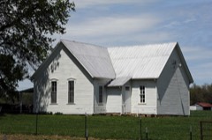 | Hudson City School | building | 2002 | 02001110 |
 | Palace Hotel | building | 2002 | 02000795 |
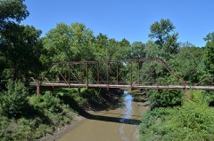 | Papinville Marais des Cygnes River Bridge | structure | 2002 | 02001192 |
Every wildfire the federal occurrence database records inside this county: 36 of them, burning about 566 acres. None started naturally and 2 were recorded as arson. Each settlement page carries the fires within five miles of it.
| Reported cause | Fires |
|---|---|
| Missing data/not specified/undetermined | 16 |
| Debris and open burning | 12 |
| Equipment and vehicle use | 4 |
| Arson/incendiarism | 2 |
| Smoking | 1 |
| Railroad operations and maintenance | 1 |
The five largest, by the area the report gives. None of them was recorded as arson.
| Date | Cause | Size | Reported by | Name on the report |
|---|---|---|---|---|
| 27 January 2002 | Missing data/not specified/undetermined | 200 acres | Marais des Cygnes National Wildlife Refuge | PRICE |
| 31 July 2012 | Missing data/not specified/undetermined | 100 acres | Missouri Department of Conservation | COOK T |
| 13 April 2010 | Missing data/not specified/undetermined | 50 acres | Marais des Cygnes National Wildlife Refuge | STATELINE SOUTH RIVER |
| 14 February 2006 | Missing data/not specified/undetermined | 40 acres | Marais des Cygnes National Wildlife Refuge | AMORET |
| 7 April 1999 | Missing data/not specified/undetermined | 31 acres | Marais des Cygnes National Wildlife Refuge | MO CROSS |
| 16 January 1992 | Railroad operations and maintenance | 20 acres | Missouri Department of Conservation | not named |
| 25 January 2018 | Equipment and vehicle use | 15 acres | Missouri Department of Conservation | 176440-00748-01252018-1355 |
| 13 March 2018 | Missing data/not specified/undetermined | 12 acres | Missouri Department of Conservation | 176443-00748-03132018-1850 |
Every settlement page carries the fires within five miles of it - see the settlement index below.
The NOAA Storm Events Database holds 362 reports for this county, causing 1 death, 3 injuries and about $15,813,360 in recorded property damage. Each settlement page carries the reports that name it.
| Kind of event | Reports |
|---|---|
| Hail | 188 |
| Thunderstorm Wind | 117 |
| Tornado | 28 |
| Flash Flood | 20 |
| Flood | 6 |
| Funnel Cloud | 1 |
| Heavy Rain | 1 |
| Lightning | 1 |
The most serious of them, by death, then injury, then recorded damage. The accounts are quoted exactly as the forecast office filed them.
| When | Event | Place named | Harm | What the report says |
|---|---|---|---|---|
| May 2020 | Thunderstorm Wind | Lacyville | 1 killed | A gradually decaying supercell produced a significant downburst as it crossed into western Missouri. The worst of the damage occurred in the Amsterdam and Passaic area, where a single fatality occurred due to a large tree falling into a home. |
| December 1956 | Tornado (F2) | not stated | 2 hurt, $25,000 | no account filed |
| September 1973 | Tornado (F1) | not stated | 1 hurt, $25,000 | no account filed |
| June 2007 | Heavy Rain | Hume | $7,000,000 | A total of 14.75 inches of rain was reported over a three day period. Major flooding of the Marais Des Cygnes River was reported across the southern part of the county. Damage was reported to many homes and businesses, as well as to railroad tracks and roads. Agricultural losses were significant. |
| May 2003 | Hail | Adrian | $6,750,000 | Large hail damaged 1,100 homes and 750 cars. |
| April 1994 | Thunderstorm Wind | Butler | $500,000 | Out buildings were knocked down and large trees blown down. |
| March 2006 | Tornado (F0) | Amsterdam | $400,000 | Tornado crossed into Bates county from Linn county Kansas at 1424 CST...2 miles west-southwest of Amsterdam. The F0 tornado caused damage to several buildings in Amsterdam. The tornado then continued northeast over rural areas with damage limited to trees. The tornado then lifted 1 mile northwest of Adrian at 1442 CST. |
| November 1991 | Tornado (F1) | not stated | $250,000 | no account filed |
| May 1982 | Tornado (F2) | not stated | $250,000 | no account filed |
| April 1969 | Tornado (F2) | not stated | $250,000 | no account filed |
| March 2006 | Hail | Virginia | $75,000 | no account filed |
| February 2007 | Tornado (EF1) | Amsterdam | $50,000 | The supercell thunderstorm which earlier had produced an EF4 tornado in Linn county Kansas, moved east-northeast into Bates county and spawned another tornado, EF1 in intensity, 3 miles east southeast of Amsterdam at 8:27 PM CST and then traveled over rural areas to the northeast, before lifting 3 miles west of Adrian at 8:37 PM CST. Major damage to one residence was noted, along with minor damage to other outbuildings. Trees and power poles were downed as well. |
| March 2009 | Thunderstorm Wind | Rich Hill | $25,000 | Thunderstorms with winds gusting to an estimated 70 mph, caused large trees to be uprooted. There was also damage to shingles and siding on several homes. A large window was blown out of a residential home, and three power poles and their power lines were downed. |
| June 2008 | Tornado (EF0) | Foster | $25,000 | Brief EF0 tornado touchdown at 2215CST in Foster. Damage was to trees and several roofs in a 2 block area. Several of the trees fell|on vehicles. |
| May 1995 | Tornado (F1) | Merwin to | $25,000 | A brief tornado touched down in the northwest part of the county, about 5 miles east of Merwin. It moved east for about 5 miles along state Route 18 before lifting about 4 miles west of Adrian near the junction with route FF. Numerous large trees were knocked down, as well as several utility poles and signs. |
| March 2006 | Hail | Butler | $25,000 | no account filed |
| May 2003 | Hail | Adrian | $25,000 | no account filed |
| April 1967 | Tornado (F1) | not stated | $25,000 | no account filed |
| August 2015 | Thunderstorm Wind | Rich Hill | $20,000 | There were several reports of damaged roofs and several trees down near Rich Hill. Telephone poles were also down across the area from these strong winds. |
| February 2007 | Hail | Amsterdam | $12,000 | Several residences and vehicles received damage from the large hail. |
| April 2015 | Tornado (EF0) | Virginia | $10,000 | A brief and weak tornado formed from a well-formed supercell in western Bates County. Only one structure was known to be hit, which was a large machine shop at a personal residence 5 miles southeast of Amoret, Missouri. No injuries were related to this tornado. |
| July 2004 | Thunderstorm Wind | Butler | $10,000 | Mobile home blown over and several barns damaged. trees and power lines down. |
| March 2006 | Tornado (F2) | Butler | $5,000 | Tornado touched down at 1952 CST just on the north side of Butler...and then proceeded northeast over rural country...before crossing over into Cass county 2 miles north of Ballard at 2005 CST. Damage was limited to trees...power lines...and one barn. |
| June 1994 | Hail | Amsterdam | $5,000 | A sheriff's patrol car was damaged by golf ball-size hail. |
| May 2003 | Hail | Butler | $5,000 | no account filed |
| June 2009 | Thunderstorm Wind | Merwin | $3,000 | Drexel Fire Chief reported a wind gust, estimated to be 90 mph. A house was blown off its foundation. |
| July 1972 | Tornado (F0) | not stated | $2,500 | no account filed |
| April 1967 | Tornado (F1) | not stated | $2,500 | no account filed |
| April 1964 | Tornado (F0) | not stated | $2,500 | no account filed |
| March 1953 | Tornado (F1) | not stated | $2,500 | no account filed |
| June 2009 | Lightning | Butler | $2,000 | Lightning caused damage to a house. |
| August 2003 | Thunderstorm Wind | Rockville | $2,000 | Large trees and limbs down. Minor structural damage to homes. |
| June 2015 | Thunderstorm Wind | Rich Hill | $1,000 | There was a powerline down at 3rd and Cherry Street in Rich Hill. |
| August 2009 | Thunderstorm Wind | Rich Hill | $1,000 | Trees up to 3 feet in diameter, and power lines, were reported down. |
| August 2009 | Thunderstorm Wind | Rockville | $1,000 | A power pole was snapped off, and 5 to 8 inch tree limbs, were downed. |
| May 2011 | Tornado (EF0) | Papinsville | $500 | At 1921CST a weak landspout formed along the leading line of thunderstorms, around a half mile southeast of Papinsville. The landspout traveled about 8 miles to the northeast, and lifted at 1930CST, 4.3 miles north of Rockville. Damage ranged from minor tree limb damage, to metal roof damage on older buildings. Several larger trees, but with rotten cores, were also snapped off. |
| June 1994 | Thunderstorm Wind | Amoret | $500 | Trees were uprooted. |
| August 2011 | Thunderstorm Wind | Merwin | $300 | A powerline was reported down. Thunderstorm wind gusts were estimated up to 60 mph. |
| June 1968 | Tornado (F0) | not stated | $30 | no account filed |
| August 1953 | Tornado (F0) | not stated | $30 | no account filed |
| May 2025 | Hail | Rich Hill | - | Quarter size hail in Rich Hill. |
| May 2025 | Thunderstorm Wind | Worland | - | Downed trees along Route U in Worland. |
| April 2025 | Hail | Sprague | - | Reported quarter sized hail west of Rich Hill. |
| April 2025 | Hail | Rich Hill | - | Social media report of pea to quarter size hail west and northwest of Rich Hill. Time estimated from radar. |
| June 2025 | Hail | Ballard | - | Social media picture showing quarter sized hail east of Ballard. |
| June 2025 | Thunderstorm Wind | Burdett | - | Social media report of downed power poles and power lines on Route 18 near County Road 6001 west of Adrian. |
| June 2025 | Thunderstorm Wind | Burdett | - | Social media reports of downed wires and power outages near Route AA west of Archie. |
| June 2025 | Thunderstorm Wind | Passaic | - | Social media report of downed wires near Route F west of Passaic. |
| June 2025 | Hail | Rich Hill | - | Emergency manager relayed report of quarter hail just north of Rich Hill along Interstate 49. |
| September 2025 | Hail | Adrian | - | Quarter size hail and tree and vehicle damage from strong winds on 7th Street. |
| September 2025 | Hail | Adrian | - | Quarter size hail reported south of Adrian. |
| September 2025 | Thunderstorm Wind | Adrian | - | Downed trees and limbs along 8th Street in Adrian. |
| September 2025 | Thunderstorm Wind | Adrian | - | Several downed trees and limbs near Harlequin Drive in Adrian. |
| September 2025 | Thunderstorm Wind | Adrian | - | Wind damage reported in Adrian. |
| September 2025 | Thunderstorm Wind | Long Mound | - | Several trees down and property damage at a business near CR 11004. |
| September 2025 | Thunderstorm Wind | Altona | - | Emergency Manager reports power outages due to strong wind gusts in Altona. |
| September 2025 | Thunderstorm Wind | Burdett | - | Multiple trees and powerlines down north of Route AA. |
| September 2025 | Thunderstorm Wind | Burdett | - | Trees and powerlines down WNW of Adrian. |
| September 2025 | Thunderstorm Wind | Burdett | - | Flagpole snapped, several trees and limbs downed, and minor property damage at a residence on CR 15272. |
| September 2025 | Thunderstorm Wind | Adrian | - | Trees and powerlines down making road impassible west of Adrian. |
The Survey's mineral resources record lists 72 workings inside this county. 5 still produce and 67 are closed or unrecorded. Each settlement page carries the workings within five miles of it.
| Commodity | Workings |
|---|---|
| Stone, Crushed/Broken | 60 |
| Sand and Gravel, Construction | 12 |
The least common of them first, because a county's hundredth gravel pit says nothing its first ten did not.
| Where | Site | Commodity | Status | Recorded |
|---|---|---|---|---|
| Unknown - S&G | Sand and Gravel, Construction | Past Producer | ||
| Unknown - S&G | Sand and Gravel, Construction | Past Producer | ||
| Unknown - S&G | Sand and Gravel, Construction | Past Producer | ||
| Unknown - S&G | Sand and Gravel, Construction | Past Producer | ||
| Unknown - S&G | Sand and Gravel, Construction | Past Producer | ||
| Unknown - S&G | Sand and Gravel, Construction | Past Producer | ||
| Unknown - S&G | Sand and Gravel, Construction | Past Producer | ||
| Unknown - S&G | Sand and Gravel, Construction | Past Producer | ||
| Unknown - S&G | Sand and Gravel, Construction | Past Producer | ||
| Unknown - S&G | Sand and Gravel, Construction | Past Producer | ||
| Unknown - S&G | Sand and Gravel, Construction | Past Producer | ||
| Unknown - S&G | Sand and Gravel, Construction | Past Producer | ||
| Alvis Quarry | Stone, Crushed/Broken | Past Producer | ||
| B + B Rock & Lime Quarry | Stone, Crushed/Broken | Producer | ||
| Bates Co #1 Butler Quarry | Stone, Crushed/Broken | Producer | ||
| Bates Co #2 Rosier Quarry | Stone, Crushed/Broken | Unknown | ||
| Bates Co #6 Amsterdam Quarry | Stone, Crushed/Broken | Producer | ||
| Bates County # 1 Quarry | Stone, Crushed/Broken | Past Producer | ||
| Bates County Rock Phosphate Quarry | Stone, Crushed/Broken | Past Producer | ||
| Batesco #1 Plant | Stone, Crushed/Broken | Producer | ||
| Butler City Quarry | Stone, Crushed/Broken | Past Producer | ||
| Freeto Quarry | Stone, Crushed/Broken | Past Producer | ||
| Merwin Q. Quarry | Stone, Crushed/Broken | Past Producer | ||
| Reno Mine | Stone, Crushed/Broken | Past Producer | ||
| Underwood Quarry | Stone, Crushed/Broken | Producer | ||
| Unknown - Ls | Stone, Crushed/Broken | Past Producer | ||
| Unknown - Ls. | Stone, Crushed/Broken | Past Producer | ||
| Unknown - Ls. | Stone, Crushed/Broken | Past Producer | ||
| Unknown - Ls. | Stone, Crushed/Broken | Past Producer | ||
| Unknown - Ls. | Stone, Crushed/Broken | Past Producer | ||
| Unknown - Ls. | Stone, Crushed/Broken | Past Producer | ||
| Unknown - Ls. | Stone, Crushed/Broken | Past Producer | ||
| Unknown - Ls. | Stone, Crushed/Broken | Past Producer | ||
| Unknown - Ls. | Stone, Crushed/Broken | Past Producer | ||
| Unknown - Ls. | Stone, Crushed/Broken | Past Producer | ||
| Unknown - Ls. | Stone, Crushed/Broken | Past Producer | ||
| Unknown - Ls. | Stone, Crushed/Broken | Past Producer | ||
| Unknown - Ls. | Stone, Crushed/Broken | Past Producer | ||
| Unknown - Ls. | Stone, Crushed/Broken | Past Producer | ||
| Unknown - Ls. | Stone, Crushed/Broken | Past Producer | ||
| Unknown - Ls. | Stone, Crushed/Broken | Past Producer | ||
| Unknown - Ls. | Stone, Crushed/Broken | Past Producer | ||
| Unknown - Ls. | Stone, Crushed/Broken | Past Producer | ||
| Unknown - Ls. | Stone, Crushed/Broken | Past Producer | ||
| Unknown - Ls. | Stone, Crushed/Broken | Past Producer | ||
| Unknown - Ls. | Stone, Crushed/Broken | Past Producer | ||
| Unknown - Ls. | Stone, Crushed/Broken | Unknown | ||
| Unknown - Ls. | Stone, Crushed/Broken | Past Producer | ||
| Unknown - Ls. | Stone, Crushed/Broken | Past Producer | ||
| Unknown - Ls. | Stone, Crushed/Broken | Past Producer | ||
| Unknown - Ls. | Stone, Crushed/Broken | Past Producer | ||
| Unknown - Ls. | Stone, Crushed/Broken | Past Producer | ||
| Unknown - Ls. | Stone, Crushed/Broken | Past Producer | ||
| Unknown - Ls. | Stone, Crushed/Broken | Past Producer | ||
| Unknown - Ls. | Stone, Crushed/Broken | Past Producer | ||
| Unknown - Ls. | Stone, Crushed/Broken | Past Producer | ||
| Unknown - Ls. | Stone, Crushed/Broken | Past Producer | ||
| Unknown - Ls. | Stone, Crushed/Broken | Past Producer | ||
| Unknown - Ls. | Stone, Crushed/Broken | Past Producer | ||
| Unknown - Ls. | Stone, Crushed/Broken | Past Producer | ||
| Unknown - Ls. | Stone, Crushed/Broken | Past Producer | ||
| Unknown - Ls. | Stone, Crushed/Broken | Past Producer | ||
| Unknown - Ls. | Stone, Crushed/Broken | Past Producer | ||
| Unknown - Ls. | Stone, Crushed/Broken | Past Producer | ||
| Unknown - Ls. | Stone, Crushed/Broken | Past Producer | ||
| Unknown - Ls. | Stone, Crushed/Broken | Past Producer | ||
| Unknown - Ls. | Stone, Crushed/Broken | Past Producer | ||
| Unknown - Ls. | Stone, Crushed/Broken | Past Producer | ||
| Unknown - Ls. | Stone, Crushed/Broken | Past Producer | ||
| Unknown - Ls. | Stone, Crushed/Broken | Past Producer | ||
| Unknown - Ls. | Stone, Crushed/Broken | Past Producer | ||
| Unknown - Ls. | Stone, Crushed/Broken | Past Producer |
2 books written about this county, cut here where the book itself is cut, at its printed chapters: 27 chapters in all. Every chapter is public domain, machine-read from the scan and reproduced complete. A chapter already given under one of the county's towns is not repeated in this list.
| Chapter | Length |
|---|---|
| The whole text | 69,977 words in 5 parts |
Named settlements recorded in the Geographic Names Information System, each with the topographic sheets covering it. Villages, hamlets and abandoned places alike. Each is shown with the nearest named watercourse or landform and the survey quadrangle it falls on.
West Point township · 64723 · Near Summers Mound · Amoret quadrangle
15 sheets, 1887 to 1981
Lone Oak township · 64730 · On Ehart Branch · Butler South quadrangle
14 sheets, 1887 to 1991
Prairie township · 64780 · On Hirni Slough · Papinville quadrangle
17 sheets, 1887 to 1991
Lone Oak township · 64730 · Butler South quadrangle
14 sheets, 1887 to 1991
No longer a settlement
Prairie township · 64780 · On Willow Branch · Papinville quadrangle
17 sheets, 1887 to 1991
Hudson township · 64724 · Pleasant Gap quadrangle
15 sheets, 1887 to 1981
No longer a settlement
Rockville township · 64780 · On Camp Branch · Rockville quadrangle
15 sheets, 1887 to 1991
The vanished settlements of Bates County: the places named above that are no longer on the map.