 Block
From the record
3 National Register listings published here.
Sources: the National Register database, National Park Service
39 topographic sheets cover 21 settlements here, and 3 properties are on the National Register of Historic Places.
3 National Register listings published here.
Sources: the National Register database, National Park Service
Every property in this county listed on the National Register of Historic Places, with the year it was listed and the federal nomination document.
| Photograph | Property | Type | Listed | Reference |
|---|---|---|---|---|
 | Caldwell County Courthouse | building | 1972 | 72000707 |
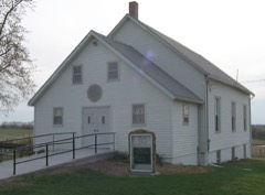 | Far West | site | 1970 | 70000324 |
| Switzer, P.A. Residence | building | 2024 | 100009692 |
Every wildfire the federal occurrence database records inside this county: 32 of them, burning about 1,382 acres. None started naturally and 1 was recorded as arson. Each settlement page carries the fires within five miles of it.
| Reported cause | Fires |
|---|---|
| Debris and open burning | 21 |
| Missing data/not specified/undetermined | 10 |
| Arson/incendiarism | 1 |
The five largest, by the area the report gives. None of them was recorded as arson.
| Date | Cause | Size | Reported by | Name on the report |
|---|---|---|---|---|
| 23 August 2012 | Missing data/not specified/undetermined | 902 acres | Missouri Department of Conservation | HIGHWAY E |
| 7 April 2018 | Debris and open burning | 211 acres | Missouri Department of Conservation | 177697-02581-04072018-1526 |
| 16 February 2018 | Debris and open burning | 54 acres | Missouri Department of Conservation | 165995-02581-02162018-1227 |
| 11 April 2018 | Missing data/not specified/undetermined | 49 acres | Missouri Department of Conservation | 177623-02515-04112018-1535 |
| 14 June 2018 | Debris and open burning | 25 acres | Missouri Department of Conservation | 177827-02581-06142018-1514 |
| 3 March 2018 | Debris and open burning | 20 acres | Missouri Department of Conservation | 177335-08922-03032018-1214 |
| 4 January 2002 | Debris and open burning | 15 acres | Missouri Department of Conservation | not named |
| 26 November 1999 | Missing data/not specified/undetermined | 10 acres | Missouri Department of Conservation | not named |
Every settlement page carries the fires within five miles of it - see the settlement index below.
The NOAA Storm Events Database holds 219 reports for this county, causing 1 death, 4 injuries and about $3,378,500 in recorded property damage. Each settlement page carries the reports that name it.
| Kind of event | Reports |
|---|---|
| Hail | 102 |
| Thunderstorm Wind | 84 |
| Flash Flood | 13 |
| Tornado | 11 |
| Flood | 9 |
The most serious of them, by death, then injury, then recorded damage. The accounts are quoted exactly as the forecast office filed them.
| When | Event | Place named | Harm | What the report says |
|---|---|---|---|---|
| April 1975 | Tornado (F4) | not stated | 1 killed, 3 hurt, $2,500,000 | no account filed |
| March 1955 | Tornado (F3) | not stated | 1 hurt, $250,000 | no account filed |
| March 1955 | Tornado (F3) | not stated | $250,000 | no account filed |
| June 1998 | Thunderstorm Wind | Polo | $70,000 | A storm survey team from the National Weather Service Office in Pleasant Hill, MO reported straight line wind damage in Polo and Braymer. Several sheds were damaged in Polo. On County Road KK along the southeast side of Braymer, a doublewide mobile home was destroyed. Diagonally across the street from the destroyed mobile home, a barn, a chicken house and a grain bin were destroyed on a farmsted. A horse on this property was killed by flying debris. |
| September 1993 | Hail | Kingston | $50,000 | Numerous windows were broken by baseball-size hail in Kingston. Heavy rains also flooded County Roads U and A. Shoal Creek overtopped levees flooding approximately 10,000 acres at a lost of over $2 million. |
| April 1994 | Thunderstorm Wind | Hamilton | $50,000 | no account filed |
| August 2005 | Thunderstorm Wind | Cowgill | $25,000 | Two barns were destroyed. |
| October 1998 | Thunderstorm Wind | Kidder | $25,000 | Several outbuildings damaged and trees downed. wind speed estimated. |
| May 2004 | Hail | Nettleton | $25,000 | no account filed |
| March 1974 | Tornado (F1) | not stated | $25,000 | no account filed |
| January 1967 | Tornado (F0) | not stated | $25,000 | no account filed |
| May 2021 | Thunderstorm Wind | Cowgill | $15,000 | Property owner near Cowgill reported a few 1 to 2 foot diameter trees down, along with some shingle damage to the roof of the home and a metal roof peeled back on the barn. |
| September 2000 | Thunderstorm Wind | Hamilton | $15,000 | Law enforcement officials reported trees and power lines down, and minor damage to a building. |
| October 2021 | Tornado (EF1) | Mirabile | $10,000 | This tornado developed just east of Interstate 35 in Clinton County, MO. It quickly crossed into Caldwell County, MO where it damaged several trees and a few buildings. The tornado dissipated just east of Goose Creek and State Route D. |
| June 2016 | Thunderstorm Wind | Hamilton | $10,000 | A large tree was reported down on a vehicle parked at a residence in Hamilton, Missouri. |
| September 2001 | Thunderstorm Wind | Hamilton | $10,000 | Building blown down next to grain silo. Numerous trees and power lines down. A propane tank was blown over. An ambulance was blown of the road. |
| June 1996 | Thunderstorm Wind | Kingston | $5,000 | no account filed |
| April 1995 | Hail | Kingston | $5,000 | no account filed |
| December 1975 | Tornado (F1) | not stated | $2,500 | no account filed |
| June 2010 | Thunderstorm Wind | Kidder | $2,000 | Semi truck was blown over at the intersection of Highways 36 and 7. |
| May 2008 | Thunderstorm Wind | Polo | $2,000 | Power lines were downed with power outages reported across the county. |
| June 2001 | Thunderstorm Wind | Mirabile | $2,000 | no account filed |
| May 2008 | Thunderstorm Wind | Mirabile | $1,000 | Damage was reported to a trailer. |
| March 2006 | Thunderstorm Wind | Cowgill | $1,000 | Trees and power lines down. |
| November 2005 | Thunderstorm Wind | Polo | $1,000 | Plate glass window blown out of business. |
| May 2004 | Thunderstorm Wind | Polo | $1,000 | Minor damage to a building and trees down. |
| August 2004 | Thunderstorm Wind | Cowgill | $1,000 | Large tree and power lines down. |
| April 2026 | Hail | Hamilton | - | Quarter sized hail reported just south of Hamilton. |
| April 2026 | Hail | Nettleton | - | Quarter sized hail reported north of Hamilton. |
| April 2026 | Hail | Hamilton | - | Quarter sized hail reported east of Hamilton. |
| May 2025 | Thunderstorm Wind | Hamilton | - | Downed wires and power outages in the Hamilton area. |
| May 2025 | Thunderstorm Wind | Mirabile | - | Social media report of downed tree on County Road 465. |
| May 2025 | Thunderstorm Wind | Polo | - | Downed wires and power outages near Route 116 west of Polo. |
| March 2025 | Thunderstorm Wind | Kingston | - | Damaged out buildings and roof blown off machine shed. |
| March 2025 | Thunderstorm Wind | Polo | - | Downed tree and wires near Holstein Road. |
| March 2024 | Hail | Cowgill | - | Quarter sized hail just southeast of Cowgill. |
| October 2024 | Thunderstorm Wind | Hamilton | - | Estimated 60 mph wind gusts in the Liberty area. |
| October 2024 | Hail | Mirabile | - | Mping report of quarter size hail north of Elmira. |
| June 2023 | Hail | Polo | - | Quarter sized hail was reported in Polo. |
| August 2023 | Thunderstorm Wind | Braymer | - | Power line downed in Braymer. |
| July 2023 | Thunderstorm Wind | Cowgill | - | Estimated 60 mph winds with trees and power lines downed in Cowgill. |
| July 2023 | Thunderstorm Wind | Breckenridge | - | Estimated 60 mph wind gusts in Breckenridge. |
| July 2022 | Thunderstorm Wind | Kingston | - | Emergency management reported 60 mph wind gust. |
| June 2021 | Flood | Polo | - | Several roads in and around Polo were flooded, and a few vehicles stalled under the railroad viaduct in Polo. |
| June 2021 | Flash Flood | Polo | - | The sewage treatment plant in Polo was flooded. |
| June 2021 | Flood | Cowgill | - | There was a social media report of some flooding over Highway F near Cowgill. |
| July 2020 | Thunderstorm Wind | Polo | - | A large tree was down in the city of Polo with several other large limbs down across the town. |
| May 2019 | Flood | Braymer | - | Route N was closed in both directions. |
| August 2018 | Thunderstorm Wind | Cowgill | - | A 5 inch tree limb was snapped. Report was received via social media. |
| October 2018 | Tornado (EF0) | Polo | - | This is a continuation of a tornado that formed in northern Ray County and crossed Price Road into Caldwell County. The tornado did some minor tree damage along its path. |
| April 2017 | Flood | Braymer | - | State Route N was closed due to flooding along Mud Creek. |
| April 2017 | Flood | Catawba | - | State Route A was closed due to flooding along Shoal and Panther Creeks. |
| March 2017 | Thunderstorm Wind | Kidder | - | Report of a shed roof blown onto the road approximately 4 miles north of HWY 136 on Route N. |
| March 2017 | Thunderstorm Wind | Braymer | - | Several outbuildings were damaged across portions of Caldwell County near Braymer. |
| August 2016 | Flash Flood | Catawba | - | Route A near Shoal Creek was closed due to flash flooding. |
| August 2016 | Flash Flood | Braymer | - | Highway N near Mud Creek was closed due to flash flooding. |
| September 2016 | Flood | Black Oak | - | State Route E was closed in both directions due to flooding on Mud Creek. While the damage was largely minimal the amount of damage was unknown. |
| September 2016 | Flood | Hamilton | - | State Route F was closed due to flooding on Shoal Creek. While the damage was largely minimal the amount of damage was unknown. |
| September 2016 | Flood | Barwick | - | Ten inches of water was reported over tri-county line road and 324th St over a 100 yard span. While the damage was largely minimal the amount of damage was unknown. |
| September 2016 | Flood | Braymer | - | State Routes C, D, DD were closed from Utica to Plymouth. While the damage was largely minimal the amount of damage was unknown. |
The Survey's mineral resources record lists 27 workings inside this county. 4 still produce and 23 are closed or unrecorded. Each settlement page carries the workings within five miles of it.
| Commodity | Workings |
|---|---|
| Stone, Crushed/Broken | 27 |
| Sand and Gravel, Construction | 1 |
The least common of them first, because a county's hundredth gravel pit says nothing its first ten did not.
| Where | Site | Commodity | Status | Recorded |
|---|---|---|---|---|
| Bridgewater Quarry | Stone, Crushed/Broken, Sand and Gravel, Construction | Past Producer | ||
| Braymer Quarry | Stone, Crushed/Broken | Producer | ||
| Breckenridge Quarry | Stone, Crushed/Broken | Producer | ||
| Everett Qsy # 6 | Stone, Crushed/Broken | Producer | ||
| Nettelton Quarry | Stone, Crushed/Broken | Producer | ||
| Unknow | Stone, Crushed/Broken | Past Producer | ||
| Unknown | Stone, Crushed/Broken | Past Producer | ||
| Unknown | Stone, Crushed/Broken | Past Producer | ||
| Unknown | Stone, Crushed/Broken | Past Producer | ||
| Unknown | Stone, Crushed/Broken | Past Producer | ||
| Unknown | Stone, Crushed/Broken | Past Producer | ||
| Unknown | Stone, Crushed/Broken | Past Producer | ||
| Unknown | Stone, Crushed/Broken | Past Producer | ||
| Unknown | Stone, Crushed/Broken | Past Producer | ||
| Unknown | Stone, Crushed/Broken | Past Producer | ||
| Unknown | Stone, Crushed/Broken | Past Producer | ||
| Unknown | Stone, Crushed/Broken | Past Producer | ||
| Unknown | Stone, Crushed/Broken | Past Producer | ||
| Unknown | Stone, Crushed/Broken | Past Producer | ||
| Unknown | Stone, Crushed/Broken | Past Producer | ||
| Unknown | Stone, Crushed/Broken | Past Producer | ||
| Unknown | Stone, Crushed/Broken | Past Producer | ||
| Unknown | Stone, Crushed/Broken | Past Producer | ||
| Unknown | Stone, Crushed/Broken | Past Producer | ||
| Unknown | Stone, Crushed/Broken | Prospect | ||
| Unknown | Stone, Crushed/Broken | Past Producer | ||
| Unknown | Stone, Crushed/Broken | Past Producer |
Named settlements recorded in the Geographic Names Information System, each with the topographic sheets covering it. Villages, hamlets and abandoned places alike. Each is shown with the nearest named watercourse or landform and the survey quadrangle it falls on.
Kidder township · 64649 · On West Sheep Creek · Hamilton West quadrangle
14 sheets, 1924 to 1986
Mirabile township · 64429 · On Willow Branch · Cameron East quadrangle
14 sheets, 1924 to 1986
New York township · 64637 · On Cottonwood Creek · Hamilton East quadrangle
11 sheets, 1924 to 1984
Kingston township · 64650 · On Mill Creek · Hamilton West quadrangle
14 sheets, 1924 to 1986
New York township · 64644 · On Little Otter Creek · Hamilton East quadrangle
11 sheets, 1924 to 1984
New York township · 64637 · On Crabapple Creek · Hamilton East quadrangle
11 sheets, 1924 to 1984