 Block
From the record
4 National Register listings published here.
Sources: the National Register database, National Park Service
41 topographic sheets cover 25 settlements here, and 4 properties are on the National Register of Historic Places.
4 National Register listings published here.
Sources: the National Register database, National Park Service
Every property in this county listed on the National Register of Historic Places, with the year it was listed and the federal nomination document.
| Photograph | Property | Type | Listed | Reference |
|---|---|---|---|---|
 | Albany Carnegie Public Library | building | 1990 | 90000130 |
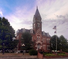 | Gentry County Courthouse | building | 1980 | 80002352 |
| Opera Hall Block | building | 2002 | 02000472 | |
| Samuel and Pauline Peery House | building | 2005 | 05000881 |
Every wildfire the federal occurrence database records inside this county: 9 of them, burning about 95 acres. None started naturally and none was recorded as arson. Each settlement page carries the fires within five miles of it.
| Reported cause | Fires |
|---|---|
| Missing data/not specified/undetermined | 6 |
| Debris and open burning | 3 |
The five largest, by the area the report gives. None of them was recorded as arson.
| Date | Cause | Size | Reported by | Name on the report |
|---|---|---|---|---|
| 19 March 2013 | Missing data/not specified/undetermined | 80 acres | Missouri Department of Conservation | not named |
| 5 June 1992 | Debris and open burning | 5.0 acres | Missouri Department of Conservation | not named |
| 3 February 1992 | Debris and open burning | 3.0 acres | Missouri Department of Conservation | not named |
| 29 February 1992 | Debris and open burning | 2.0 acres | Missouri Department of Conservation | not named |
| 7 June 1992 | Missing data/not specified/undetermined | 1.0 acres | Missouri Department of Conservation | not named |
| 4 June 1992 | Missing data/not specified/undetermined | 1.0 acres | Missouri Department of Conservation | not named |
| 27 March 1992 | Missing data/not specified/undetermined | 1.0 acres | Missouri Department of Conservation | not named |
| 9 February 1992 | Missing data/not specified/undetermined | 1.0 acres | Missouri Department of Conservation | not named |
Every settlement page carries the fires within five miles of it - see the settlement index below.
The NOAA Storm Events Database holds 233 reports for this county, causing no deaths, 1 injury and about $16,459,450 in recorded property damage. Each settlement page carries the reports that name it.
| Kind of event | Reports |
|---|---|
| Hail | 114 |
| Thunderstorm Wind | 72 |
| Tornado | 21 |
| Flash Flood | 20 |
| Heavy Rain | 5 |
| Flood | 1 |
The most serious of them, by death, then injury, then recorded damage. The accounts are quoted exactly as the forecast office filed them.
| When | Event | Place named | Harm | What the report says |
|---|---|---|---|---|
| May 2004 | Tornado (F2) | Stanberry | 1 hurt, $10,000,000 | This F2 tornado was consistently on the ground from one mile south of Stanberry east-northeastthrough Albany. Muliple vortices were noticed on chaser video. Extensive damage was observed in Albany. Three homes were destroyed. There were 34 buildings with major damage and 70 buildings had minor damage. |
| June 2004 | Hail | Albany | $5,600,000 | Windshield damage to cars. Roofs on many houses and businesses had shingle damage...along with broken windows |
| April 1984 | Tornado (F2) | not stated | $250,000 | no account filed |
| April 1981 | Tornado (F1) | not stated | $250,000 | no account filed |
| July 2004 | Flash Flood | Gentry | $100,000 | Bridge washed out on U Highway. |
| June 1998 | Thunderstorm Wind | Albany Meml Arpt | $100,000 | Severe thunderstorm winds overturned a small aircraft at Albany Airport. |
| April 1995 | Hail | not stated | $30,000 | Nickel- to quarter-size hail fell continuously between 0830 and 0900 CST in the Albany and Stanberry areas. Hail covered the ground and some minor car damage was reported. |
| June 1974 | Tornado (F0) | not stated | $25,000 | no account filed |
| September 1959 | Tornado (F1) | not stated | $25,000 | no account filed |
| April 1995 | Hail | Stanberry | $20,000 | Nickel- to quarter-size hail fell continuously between 0830 and 0900 CST in the Albany and Stanberry areas. Hail covered the ground and some minor car damage was reported. |
| July 2005 | Thunderstorm Wind | Albany | $5,000 | Barn destroyed also many large trees down and corn fields flattened. |
| May 1995 | Thunderstorm Wind | Albany | $5,000 | Severe Thunderstorms produced damaging winds north of Albany, causing light damage to a few buildings. Another line of storms later produced 60 mph winds as it passed. |
| July 2012 | Thunderstorm Wind | King City | $4,000 | Several power poles were blown over in King city. A truck was also overturned. Thunderstorm wind gusts were estimated up to 60 mph. |
| June 1995 | Thunderstorm Wind | King City | $4,000 | Severe thunderstorms moved through the county, producing wind gusts up to 60 mph in the King City area. Numerous power outages were reported. |
| July 1995 | Thunderstorm Wind | Albany | $4,000 | Thunderstorms produced winds gusts up to 60 mph as they moved through Gentry County. There were several reports of downed trees and powerlines. In Albany there was also a report of minor flash flooding. |
| August 2011 | Thunderstorm Wind | Stanberry | $3,000 | A barn was reported destroyed. Thunderstorm wind gusts were estimated up to 70 mph. |
| August 2011 | Thunderstorm Wind | Mcfall | $3,000 | Power poles were reported snapped off. Thunderstorm wind gusts were estimated up to 70 mph. |
| April 2010 | Thunderstorm Wind | Pinhook | $3,000 | A barn roof was reported to be peeled off. |
| May 1995 | Tornado (F0) | Martinsville | $3,000 | ,2107cst A weak tornado briefly touched down near Martinsville, with only very minor damage. Harrison Co. 6 W Andover,27,2103CST,.4,15,0,0,0,0,Tornado (F0) A weak tornado touched down 4 miles west of Interstate 35, near Route KK just south of the Iowa border, and about 5 miles southwest of Lamoni, IA. No reports of damage were received in Missouri, however the tornado crossed into Decatur county Iowa where it damaged a farm just across the border. (See additional reports from the Des Moines, IA office - DSM). |
| April 1973 | Tornado (F2) | not stated | $2,500 | no account filed |
| April 1973 | Tornado (F2) | not stated | $2,500 | no account filed |
| June 1966 | Tornado (F1) | not stated | $2,500 | no account filed |
| May 1995 | Tornado (F0) | Eagleville | $2,000 | ,2114cst A weak tornado briefly touched down west of Eagleville, uprooting a large tree at the junction of Routes D and M. Eagleville,27,2125CST,0,0,0,0,5K,0,Tstm Wind Severe thunderstorms produced damaging winds which downed power lines in Eagleville. |
| June 1995 | Thunderstorm Wind | McFall | $2,000 | Numerous trees were downed by strong thunderstorm winds. |
| July 1995 | Thunderstorm Wind | not stated | $2,000 | High winds in thunderstorms caused numerous downed trees and power line. |
| June 1996 | Thunderstorm Wind | King City | $2,000 | no account filed |
| July 2012 | Thunderstorm Wind | King City | $1,000 | Thunderstorm wind gusts were estimated up to 60 mph. Minor damage was reported at the Willcross Seed building in King City. |
| June 2011 | Thunderstorm Wind | King City | $1,000 | Power lines were reported down. Thunderstorm wind gusts were estimated up to 60 mph. |
| April 2010 | Thunderstorm Wind | Albany | $1,000 | A machine shed was severely damaged, in thunderstorm wind gusts estimated up to 60 mph. Some of the debris was carried a half mile downwind. |
| June 2008 | Thunderstorm Wind | Albany | $1,000 | Few power lines were reported down. |
| April 2006 | Thunderstorm Wind | King City | $1,000 | Trees and power lines downed. |
| April 2006 | Thunderstorm Wind | Stanberry | $1,000 | Trees downed and home had damage to awnings and roof. |
| May 2005 | Thunderstorm Wind | Albany | $1,000 | Trees and power lines downed. |
| May 2005 | Thunderstorm Wind | King City | $1,000 | Power lines downed. |
| June 2005 | Thunderstorm Wind | Albany | $1,000 | Power poles and lines downed. |
| July 2012 | Thunderstorm Wind | Albany | $250 | Trees were reported down and a pontoon boat was thrown into a road. Power outages were reported in the town of Albany. Thunderstorm wind gusts were estimated up to 60 mph. |
| May 1954 | Tornado (F0) | not stated | $250 | no account filed |
| May 1952 | Tornado (F1) | not stated | $250 | no account filed |
| July 2010 | Thunderstorm Wind | Ford City | $200 | A wooden light pole was blown over by thunderstorm winds estimated to 60 mph. |
| April 2026 | Hail | Carmack | - | Quarter sized hail was reported west of Albany. |
| May 2025 | Hail | Albany | - | Golf ball sized hail was reported near Albany. |
| May 2025 | Hail | Albany | - | Quarter sized hail reported in Albany. |
| May 2025 | Hail | Albany | - | Social media report of hail slightly larger than golf balls east of Albany. |
| June 2025 | Heavy Rain | Stanberry | - | Personal weather station from Stanberry reports 5.87 inches of rain over the course of about 36 hours. |
| June 2025 | Heavy Rain | Albany | - | Two day Cocorahs rainfall report near Albany of 8.72 inches of rain. |
| June 2025 | Heavy Rain | Alanthus Grove | - | Cocorahs report north of Stanberry of 4.25 inches of rain through 7 am June 24th. |
| June 2025 | Flash Flood | Envart | - | Flash flooding across portions of Gentry County due to widespread 6 plus inches of rain. |
| June 2025 | Heavy Rain | Albany Meml Arpt | - | Personal weather station NW of Albany. 8.54 inches over the last 28 hours. |
| April 2024 | Tornado (EF1) | Gentry | - | This EF1 tornado began near or just west of U.S. Highway 169 south of Gentry, where a tractor trailer was blown over. Little damage was observed as the tornado moved northeast to 558 Road. A residence at this location featured roof damage to the home, damage to multiple grain bins, and complete destruction of a small barn. Multiple tree limbs were downed in the area, and debris from inside the barn was strewn around the property. The tornado continued northeast from this location, but little damaged was observed beyond this point. The end point is estimated based on spotter reports of the tornado crossing into Harrison County before lifting, though it is possible the tornado ended before this. |
| June 2024 | Thunderstorm Wind | Albany | - | Trees down on top of powerlines and transformer blown in Albany. Estimated wind gusts of 65 mph. |
| June 2023 | Thunderstorm Wind | Stanberry | - | Estimated 80 mph winds. Multiple trees and power lines downed across Stanberry. |
| June 2023 | Thunderstorm Wind | Albany | - | Estimated 80 mph winds. Multiple trees and power lines downed across Albany. |
| August 2023 | Hail | Gentry | - | Golf ball sized hail was reported west of Gentry. |
| May 2023 | Hail | Albany | - | Golf ball sized hail was reported in Albany. |
| July 2023 | Thunderstorm Wind | Stanberry | - | Estimated 60 to 65 mph winds between Stanberry and Darlington. |
| July 2023 | Thunderstorm Wind | Mcfall | - | Estimated 60 mph winds in McFall. |
| June 2022 | Hail | Stanberry | - | Report was relayed via Sheriff's office. |
| June 2022 | Hail | Darlington | - | This report was received via social media. |
| June 2022 | Hail | Island City | - | This report was received via social media. |
| July 2021 | Thunderstorm Wind | Mcfall | - | A few tree limbs of 4 to 5 inches were down in McFall. |
The Survey's mineral resources record lists 77 workings inside this county. 6 still produce and 71 are closed or unrecorded. Each settlement page carries the workings within five miles of it.
| Commodity | Workings |
|---|---|
| Stone, Crushed/Broken | 44 |
| Sand and Gravel, Construction | 33 |
The least common of them first, because a county's hundredth gravel pit says nothing its first ten did not.
| Where | Site | Commodity | Status | Recorded |
|---|---|---|---|---|
| B B Sand Co S & G Pit | Sand and Gravel, Construction | Producer | ||
| Raid Quarries Div Medusa Agg Inc | Sand and Gravel, Construction | Producer | ||
| Site No. 1 | Sand and Gravel, Construction | Producer | ||
| Unk | Sand and Gravel, Construction | Past Producer | ||
| Unk | Sand and Gravel, Construction | Past Producer | ||
| Unk | Sand and Gravel, Construction | Past Producer | ||
| Unk | Sand and Gravel, Construction | Unknown | ||
| Unk | Sand and Gravel, Construction | Past Producer | ||
| Unk | Sand and Gravel, Construction | Unknown | ||
| Unk | Sand and Gravel, Construction | Past Producer | ||
| Unk | Sand and Gravel, Construction | Past Producer | ||
| Unk | Sand and Gravel, Construction | Past Producer | ||
| Unk | Sand and Gravel, Construction | Past Producer | ||
| Unk | Sand and Gravel, Construction | Past Producer | ||
| Unk | Sand and Gravel, Construction | Past Producer | ||
| Unk | Sand and Gravel, Construction | Past Producer | ||
| Unk | Sand and Gravel, Construction | Past Producer | ||
| Unk | Sand and Gravel, Construction | Past Producer | ||
| Unk | Sand and Gravel, Construction | Past Producer | ||
| Unk | Sand and Gravel, Construction | Past Producer | ||
| Unk | Sand and Gravel, Construction | Past Producer | ||
| Unk | Sand and Gravel, Construction | Past Producer | ||
| Unk | Sand and Gravel, Construction | Unknown | ||
| Unk | Sand and Gravel, Construction | Past Producer | ||
| Unk | Sand and Gravel, Construction | Past Producer | ||
| Unk | Sand and Gravel, Construction | Past Producer | ||
| Unk | Sand and Gravel, Construction | Past Producer | ||
| Unk | Sand and Gravel, Construction | Past Producer | ||
| Unk | Sand and Gravel, Construction | Past Producer | ||
| Unk | Sand and Gravel, Construction | Past Producer | ||
| Unk | Sand and Gravel, Construction | Past Producer | ||
| Unk | Sand and Gravel, Construction | Past Producer | ||
| Unk | Sand and Gravel, Construction | Past Producer | ||
| Berlin Mill | Stone, Crushed/Broken | Producer | ||
| Berlin Quarry | Stone, Crushed/Broken | Producer | ||
| Tri County Land Company | Stone, Crushed/Broken | Producer | ||
| Unk | Stone, Crushed/Broken | Past Producer | ||
| Unk | Stone, Crushed/Broken | Past Producer | ||
| Unk | Stone, Crushed/Broken | Past Producer | ||
| Unk | Stone, Crushed/Broken | Past Producer | ||
| Unk | Stone, Crushed/Broken | Past Producer | ||
| Unk | Stone, Crushed/Broken | Past Producer | ||
| Unk | Stone, Crushed/Broken | Past Producer | ||
| Unk | Stone, Crushed/Broken | Past Producer | ||
| Unk | Stone, Crushed/Broken | Past Producer | ||
| Unk | Stone, Crushed/Broken | Past Producer | ||
| Unk | Stone, Crushed/Broken | Past Producer | ||
| Unk | Stone, Crushed/Broken | Unknown | ||
| Unk | Stone, Crushed/Broken | Past Producer | ||
| Unk | Stone, Crushed/Broken | Past Producer | ||
| Unk | Stone, Crushed/Broken | Past Producer | ||
| Unk | Stone, Crushed/Broken | Past Producer | ||
| Unk | Stone, Crushed/Broken | Past Producer | ||
| Unk | Stone, Crushed/Broken | Past Producer | ||
| Unk | Stone, Crushed/Broken | Past Producer | ||
| Unk | Stone, Crushed/Broken | Past Producer | ||
| Unk | Stone, Crushed/Broken | Unknown | ||
| Unk | Stone, Crushed/Broken | Unknown | ||
| Unk | Stone, Crushed/Broken | Unknown | ||
| Unk | Stone, Crushed/Broken | Past Producer | ||
| Unk | Stone, Crushed/Broken | Past Producer | ||
| Unk | Stone, Crushed/Broken | Unknown | ||
| Unk | Stone, Crushed/Broken | Past Producer | ||
| Unk | Stone, Crushed/Broken | Past Producer | ||
| Unk | Stone, Crushed/Broken | Past Producer | ||
| Unk | Stone, Crushed/Broken | Past Producer | ||
| Unk | Stone, Crushed/Broken | Past Producer | ||
| Unk | Stone, Crushed/Broken | Unknown | ||
| Unk | Stone, Crushed/Broken | Past Producer | ||
| Unk | Stone, Crushed/Broken | Past Producer | ||
| Unk | Stone, Crushed/Broken | Past Producer | ||
| Unk | Stone, Crushed/Broken | Past Producer | ||
| Unk | Stone, Crushed/Broken | Past Producer | ||
| Unk | Stone, Crushed/Broken | Past Producer | ||
| Unk | Stone, Crushed/Broken | Unknown | ||
| Unk | Stone, Crushed/Broken | Past Producer | ||
| Unk | Stone, Crushed/Broken | Unknown |
Named settlements recorded in the Geographic Names Information System, each with the topographic sheets covering it. Villages, hamlets and abandoned places alike. Each is shown with the nearest named watercourse or landform and the survey quadrangle it falls on.
Wilson township · 64489 · On Zounds Creek · Alanthus Grove quadrangle
11 sheets, 1940 to 1986
Athens township · 64402 · On Town Branch · Albany South quadrangle
12 sheets, 1925 to 1986
No longer a settlement
Cooper township · 64438 · On Middle Fork Grand River · Darlington quadrangle
12 sheets, 1925 to 1986
Athens township · 64402 · On Jacks Branch · Albany South quadrangle
12 sheets, 1925 to 1986
Howard township · 64402 · On Clayber Branch · Albany North quadrangle
12 sheets, 1942 to 1986
Wilson township · 64453 · On Grantham Creek · Alanthus Grove quadrangle
11 sheets, 1940 to 1986
Miller township · 64402 · On Stillhouse Branch · Albany South quadrangle
12 sheets, 1925 to 1986
Jackson township · 64489 · On Turkey Creek · Stanberry quadrangle
13 sheets, 1925 to 1986
Howard township · 64441 · Near Possum Hollow · Albany North quadrangle
12 sheets, 1942 to 1986
Howard township · 64402 · On Panther Creek · Albany North quadrangle
12 sheets, 1942 to 1986
Howard township · 64441 · On Little Muddy Creek · Albany North quadrangle
12 sheets, 1942 to 1986
Huggins township · 64489 · Near Redmond Hill · Gentry quadrangle
12 sheets, 1942 to 1986
No longer a settlement
The vanished settlements of Gentry County: the places named above that are no longer on the map.