 Block
From the record
12 National Register listings published here.
Sources: the National Register database, National Park Service
61 topographic sheets cover 28 settlements here, and 12 properties are on the National Register of Historic Places.
12 National Register listings published here.
Sources: the National Register database, National Park Service
Every property in this county listed on the National Register of Historic Places, with the year it was listed and the federal nomination document.
| Photograph | Property | Type | Listed | Reference |
|---|---|---|---|---|
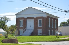 | First Presbyterian Church | building | 2012 | 12000562 |
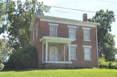 | William Gray House | building | 1999 | 99000666 |
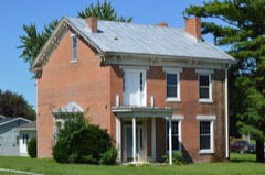 | Dr. J.A. Hay House | building | 1999 | 99000664 |
 | Henderson Hall | building | 1978 | 78001666 |
| Joseph Hipkins House | building | 2008 | 08000376 | |
 | Lewis County Courthouse | building | 2005 | 04001476 |
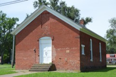 | Lincoln School | building | 1983 | 83001029 |
 | Lock and Dam No. 20 Historic District | district | 2004 | 04000180 |
 | John McKoon House | building | 1999 | 99000665 |
| Quincy, Missouri, and Pacific Railroad Station | building | 1979 | 79001379 | |
| Fred Rhoda House | building | 1999 | 99000662 | |
 | A.C. Waltman House | building | 1999 | 99000663 |
Every wildfire the federal occurrence database records inside this county: 98 of them, burning about 1,358 acres. None started naturally and none was recorded as arson. Each settlement page carries the fires within five miles of it.
| Reported cause | Fires |
|---|---|
| Debris and open burning | 43 |
| Missing data/not specified/undetermined | 42 |
| Equipment and vehicle use | 10 |
| Misuse of fire by a minor | 2 |
| Smoking | 1 |
The five largest, by the area the report gives. None of them was recorded as arson.
| Date | Cause | Size | Reported by | Name on the report |
|---|---|---|---|---|
| 4 November 1999 | Debris and open burning | 280 acres | Missouri Department of Conservation | not named |
| 18 April 1994 | Debris and open burning | 100 acres | Missouri Department of Conservation | not named |
| 29 April 2018 | Missing data/not specified/undetermined | 96 acres | Missouri Department of Conservation | 177807-02079-04292018-1543 |
| 25 January 2002 | Missing data/not specified/undetermined | 75 acres | Missouri Department of Conservation | not named |
| 3 November 1996 | Debris and open burning | 65 acres | Missouri Department of Conservation | not named |
| 20 October 1996 | Smoking | 50 acres | Missouri Department of Conservation | not named |
| 7 April 1994 | Debris and open burning | 50 acres | Missouri Department of Conservation | not named |
| 3 February 2018 | Missing data/not specified/undetermined | 43 acres | Missouri Department of Conservation | 177708-02079-02032018-1156 |
Every settlement page carries the fires within five miles of it - see the settlement index below.
The NOAA Storm Events Database holds 279 reports for this county, causing 3 deaths, 16 injuries and about $9,409,500 in recorded property damage. Each settlement page carries the reports that name it.
| Kind of event | Reports |
|---|---|
| Hail | 115 |
| Thunderstorm Wind | 110 |
| Flash Flood | 27 |
| Tornado | 14 |
| Flood | 9 |
| Lightning | 3 |
| Funnel Cloud | 1 |
The most serious of them, by death, then injury, then recorded damage. The accounts are quoted exactly as the forecast office filed them.
| When | Event | Place named | Harm | What the report says |
|---|---|---|---|---|
| July 2015 | Thunderstorm Wind | La Grange | 1 killed | Sub-severe thunderstorm winds in combination with saturated soils, caused a large tree to be blown over at Wakonda State Park in the area where RVs are allowed to stay. The tree fell onto an RV, crushing the front section of it. Five people were trapped in the vehicle. One occupant was crushed by the fallen tree and died from his injuries. No one else in the vehicle sustained any injuries. |
| July 2015 | Flash Flood | La Grange | 1 killed | Up to five inches of rain fell onto already saturated soils causing flash flooding. Numerous roads were flooded including Highways C and B at LaGrange. County Road 322, also known as 190th Street, was flooded where Reddish Branch Creek flows under it, about 3 miles east northeast of LaBelle, just east of intersection with 145th Avenue. In this location, a pickup truck was driven into the flooded roadway just after midnight on the 12th of July and then swept downstream. The driver was swept about a mile downstream and drowned in the flood waters. Her passenger was able to cling to a tree till he was rescued a few hours later. Several roads were also washed out including 3rd Street at Pierce Street in LaGrange. |
| May 2010 | Flood | Monticello | 1 killed | At 245 am, a young woman was travelling west of County Road 195th, when the car she was driving in went into water covering the road due to the North Fabius River, which was in flood. The car became completely submerged and she perished. The North Fabius River was at 21.16 feet at the time of the accident, over ten feet above flood stage, which is 11 feet. The river crested later that morning at 22.19 feet around 1030 am. This is the second highest crest since the gage was installed in June of 2005. |
| May 2003 | Tornado (F2) | Steffenville | 6 hurt, $5,000,000 | A tornado formed just north of the Marion Lewis County line and continued northeast for 20 miles, eventually causing major damage in the city of Canton. The tornado first formed southeast of Steffenville where it damaged a barn and other outbuildings. Six homes suffered varying degrees of roof damage as the tornado crossed Highway N south of Ewing. The tornado crossed Highway 6 southeast of Ewing and damaged an electric substation. From Highway CC north to Highway P, about 20 homes and farm buildings suffered varying degrees of roof, siding and window damage. Numerous large trees were either uprooted or snapped off near the ground as well. The tornado crossed Highway 61 just southeast of Canton where it blew two tractor trailers off the road. Two men suffered minor injuries. The tornado then entered Canton about 630 pm. Information from Emergency Management personnel and city officials in Canton revealed 75-100 structures damaged with at least 40 receiving major damage. At Culver-Stockton College on the southeast side of town, the field house was flattened and another two story building lost its roof. Several very large trees on the campus were uprooted or snapped off near the ground. Four mobile homes on the north side of town were destroyed with four others suffering major damage. There were only 4 minor injuries reported in Canton. |
| June 2005 | Lightning | Maywood | 3 hurt | Three men were injured when the truck they were standing by was struck by lightning. The men were knocked to the ground and were treated for superficial burns. The bolt melted the radio antenna, the radio, left a hole in the back window, and left burn marks on the drive's side mirror. |
| April 1999 | Tornado (F2) | La Belle | 2 hurt, $2,100,000 | no account filed |
| May 1957 | Tornado (F2) | not stated | 2 hurt, $250,000 | no account filed |
| April 1997 | Tornado (F1) | Ewing | 1 hurt, $200,000 | no account filed |
| May 2008 | Hail | Ewing | 1 hurt | A man caught outside was injured by hail which was up to 1 1/4 inch in diameter. |
| May 2008 | Hail | Ewing | 1 hurt | Hail up to two inches injured a man who was caught outside. |
| June 2008 | Flood | Fenway | $940,000 | The Mississippi River at Canton, MO crested at 27.73 feet on 6/18. This is the second highest crest ever recorded. A major sandbagging effort by the residents, the Missouri National Guard, and volunteers saved much of the town from flooding. Levee breaks upstream on the Illinois side also helped lower the crest, as initially, a record crest was expected. Further south, the town of LaGrange was not as lucky. At least 30 homes and 12 business were flooded. Damage to public infrastructure was estimated at $940,000. Agricultural damage was estimated at $8.9 million. |
| September 1993 | Thunderstorm Wind | Canton | $500,000 | Downburst wind damaged three homes along a 2-mile-long track. Width of the downburst was 100 yards with significant roof damage. Some homes lost complete sections of the roofing. Several large trees were snapped or uprooted. Damage occurred for a 30-minute period ending at 1715 CST. |
| May 1957 | Tornado (F2) | not stated | $250,000 | no account filed |
| April 2001 | Hail | Ewing | $30,000 | no account filed |
| June 1970 | Tornado (F2) | not stated | $25,000 | no account filed |
| July 1961 | Tornado (F1) | not stated | $25,000 | no account filed |
| April 1997 | Tornado (F0) | La Grange | $20,000 | no account filed |
| June 2008 | Flash Flood | Deer Ridge | $16,000 | Three to five inches of rain fell over Lewis county in a short amount of time on June 3rd. Numerous secondary roads had water flowing over them including Highway J south of Lewistown, Highway 6 in Lewistown, and Highway 16 east of Monticello. County Roads 305 and 356 had a section of road washed out due to the heavy rains. |
| September 2022 | Thunderstorm Wind | Deer Ridge | $10,000 | Thunderstorm winds caused moderate damage to a farm outbuilding. |
| May 2008 | Tornado (EF1) | Ewing | $10,000 | The tornado first formed about 1/4 mile east of Highway 6 on Heritage Road where it damaged several pine trees. The tornado moved east-northeast and damaged three machine sheds. The tornado then snapped several utility poles and damaged more machine sheds. Some of the debris from the machine sheds was tossed 200 yards with two by four boards driven into the ground. The tornado continued to damage trees just west of Highway C. The tornado crossed Highway C and damaged a machine shed and grain bin. |
| June 2024 | Hail | Williamstown | $5,000 | A trained spotter reported 2 inch hail in Williamstown. Hailstones broke multiple cars' windshields in town. |
| September 2021 | Thunderstorm Wind | Canton | $5,000 | Thunderstorm winds blew down several large trees as well a a couple of power poles around town. |
| July 2021 | Thunderstorm Wind | Ewing | $5,000 | Thunderstorm winds blew down numerous tree limbs around town. |
| April 2013 | Flood | Fenway | $5,000 | The Mississippi River rose to major flood levels along the border of Lewis County. The river crested on April 21st, but remained above flood stage into May. Damage was limited to a few roads closed and agricultural lowlands. |
| May 1994 | Hail | Lewistown | $5,000 | Hail up to golf ball-size was reported by a television station out of Quincy Il. Some small trees were also blown down. |
| December 2021 | Thunderstorm Wind | La Belle | $2,000 | Thunderstorm winds blew down a one and a half foot diameter tree in town. |
| April 2013 | Flood | Monticello | $2,000 | The Middle Fabius River rose to major flood levels. The river crested on April 20th. Damage was limited to a few closed roads and flooded farmland. |
| April 2013 | Flood | Monticello | $2,000 | The North Fabius River rose to major flood levels in Lewis County. The river crested on April 20th. Damage was limited to some closed roads and flooded farmland. |
| May 2013 | Flood | Maywood | $2,000 | no account filed |
| August 1993 | Thunderstorm Wind | La Belle | $500 | The county sheriff reported power lines and large trees down. |
| April 2026 | Thunderstorm Wind | Lewistown | - | Thunderstorm winds downed one large tree in Lewistown. |
| March 2024 | Thunderstorm Wind | La Grange | - | Thunderstorm winds blew down a large tree in La Grange. |
| June 2024 | Thunderstorm Wind | La Belle | - | Thunderstorm winds caused tree damage of varying degrees throughout Lewis County. The most extensive damage occurred in and around Ewing, La Grange, and Canton where trees and power lines were downed. Additional cities impacted were La Belle, and Maywood. |
| June 2024 | Hail | Lewistown | - | An X/Twitter post reported mostly quarters to golf ball sized hail falling in Lewistown. The person found at least one hailstone measured to be 2.5 inches and photographed the measurement. |
| June 2024 | Thunderstorm Wind | Ewing | - | Multiple roofs of farm outbuildings were removed in Ewing. The NWS damage survey concluded straight-line winds were responsible for this damage. |
| June 2024 | Thunderstorm Wind | Durham | - | Multiple trees were uprooted, multiple farm outbuildings had collapsed walls, and multiple grain silos were damaged outside of Ewing. The NWS damage survey determined straight-line winds were responsible for the damage. |
| June 2024 | Hail | La Belle | - | Multiple reports came in from the public for hailstones of 1 to 2.75 inches in diameter. The largest stones fell near La Belle. Additional cities impacted include Lewistown, Monticello, and Ewing. |
| April 2024 | Thunderstorm Wind | Canton | - | Trained spotters reported numerous tree limbs down in Canton with the largest up to 6 inches in diameter. A 3 to 4 foot diameter tree was also downed near 4th Street and Lewis Street. |
| April 2023 | Hail | Steffenville | - | A wide swath of large hail fell from Steffenville through Lewistown, Monticello and Canton. |
| June 2023 | Thunderstorm Wind | La Belle | - | Thunderstorm winds blew down numerous large tree limbs between LaBelle and Canton. Some of the fallen tree limbs blocked a lane on Highway 6 between LaBelle and Lewistown. |
| August 2023 | Flash Flood | Canton | - | Up to six inches of rain fell in a short amount of time causing flash flooding. Highway B south of Canton was closed due to flash flooding. |
| April 2021 | Thunderstorm Wind | La Belle | - | Thunderstorm winds caused minor roof damage to a mobile home. |
| June 2021 | Thunderstorm Wind | Lewistown | - | Thunderstorm winds blew down numerous large tree limbs around town. |
| June 2019 | Hail | Canton | - | Large hail fell across the La Grange area for at least 8 minutes. Some of the hail stones were up to golf ball sized. |
| October 2019 | Flash Flood | Fenway | - | Up to three inches of rain fell in a short amount of time causing flash flooding. Two to three feet of water was flowing over State Route 16 between Canton and Monticello. Also, several other secondary roads had water over them. |
| May 2019 | Flash Flood | Deer Ridge | - | Up to four inches of rain fell in a short amount of time causing flash flooding. Numerous roads were flooded including Highway 156 just west of Ewing. |
| May 2019 | Thunderstorm Wind | La Belle | - | Thunderstorm winds uprooted several large trees and knocked down several power lines. |
| May 2019 | Flash Flood | La Belle | - | Up to three inches of rain fell in a short amount of time, especially across the southern half of the county. Numerous roads were flooded, with the worst flooding in La Grange. |
| August 2019 | Thunderstorm Wind | Canton | - | Thunderstorm winds blew down an 18 inch diameter tree at the intersection of 6th Street and Lewis Street. |
| August 2018 | Thunderstorm Wind | Steffenville | - | Thunderstorm winds blew down a tree onto Highway 156 about half a mile west of intersection with Highway D. |
| July 2018 | Hail | Monticello | - | A wide swath of damaging hail fell across portions of Lewis County. In LaGrange, golfball sized hail was reported. One inch hail was reported in Durham and Maywood. |
| June 2017 | Thunderstorm Wind | Lewistown | - | Thunderstorm winds blew down several large tree limbs around town. |
| April 2016 | Tornado (EF1) | Maywood | - | A tornado touched down in a farm field north of Highway O and west of Oak Avenue, which is west-northwest of Maywood. The tornado moved east northeast directly hitting a home in its path, causing EF-1 damage by lifting a large portion of the roof from the residence. Roofing materials were found up to a half mile to the east. The tornado continued east northeast toward Oak Avenue causing significant tree damage. At Oak Avenue the tornado rolled a full size tanker truck on its side and destroyed two grain bins. The tornado continued east northeast across Olive Avenue causing additional tree damage. The tornado dissipated a few hundred yards to the east of Olive Avenue in another farm field. The tornado was rated EF-1 with a path length of 2.01 miles and a max path width of 150 yards. |
| July 2016 | Thunderstorm Wind | Ewing | - | A large tree was blown down onto a pickup truck on Route C between Routes BB and Z, northeast of Ewing. No injuries were reported. Also, a tree was blown over blocking the railroad tracks just south of La Grange. |
| November 2015 | Thunderstorm Wind | Canton | - | Thunderstorm winds blew down a large tree as well as several large tree limbs. |
| June 2015 | Flash Flood | Fenway | - | Up to 4 inches of rain fell in a short amount of time onto already saturated soils causing flash flooding. Several roads were flooded including Highway J just south of Lewistown. |
| July 2015 | Thunderstorm Wind | Lewistown | - | Thunderstorms produced a wide swath of damaging winds as it moved east southeast across the county. In Lewistown, a large tree was blown over onto an unoccupied mobile home. In Ewing, the roof was blown off of a church and numerous trees were blown down around town. In Canton, there was widespread tree damage and numerous trees uprooted or snapped off. Also, an unanchored mobile home was pushed off of its foundation. |
| June 2015 | Flash Flood | Deer Ridge | - | Up to 4 inches of rain fell onto already saturated soils causing flash flooding. Numerous roads were flooded including Highway 156 west of Ewing due to rapidly rising water from Grassy Creek. Also, Highway 156 was flooded east of Newark, in far southwestern Lewis County. |
| June 2015 | Thunderstorm Wind | Monticello | - | Thunderstorm winds blew off part of the roof of a metal barn 3 miles north of Monticello. Some of the debris was laying on Highway A. |
| June 2015 | Flash Flood | La Belle | - | Up to 5 inches of rain fell onto already saturated soils causing flash flooding. Numerous roads were flooded including Highway 156 near Ewing, Highway C east of Ewing and Highway D south of LaBelle. |
The Survey's mineral resources record lists 18 workings inside this county. 6 still produce and 12 are closed or unrecorded. Each settlement page carries the workings within five miles of it.
| Commodity | Workings |
|---|---|
| Stone, Crushed/Broken | 15 |
| Sand and Gravel, Construction | 2 |
| Limestone, Dimension | 1 |
The least common of them first, because a county's hundredth gravel pit says nothing its first ten did not.
| Where | Site | Commodity | Status | Recorded |
|---|---|---|---|---|
| Hagood Quarry | Limestone, Dimension | Past Producer | ||
| Lagrange Pit & Plant | Sand and Gravel, Construction | Producer | ||
| Unk | Sand and Gravel, Construction | Past Producer | ||
| Brosi Quarry | Stone, Crushed/Broken | Past Producer | ||
| Central Mill | Stone, Crushed/Broken | Producer | ||
| Ewing Plant | Stone, Crushed/Broken | Producer | ||
| Ewing Quarry | Stone, Crushed/Broken | Producer | ||
| Monticello Quarry 8 | Stone, Crushed/Broken | Producer | ||
| Oyster Quarry | Stone, Crushed/Broken | Past Producer | ||
| Reid + Brosi Quarry | Stone, Crushed/Broken | Past Producer | ||
| Shannon Quarry | Stone, Crushed/Broken | Producer | ||
| Unk | Stone, Crushed/Broken | Past Producer | ||
| Unk | Stone, Crushed/Broken | Past Producer | ||
| Unk | Stone, Crushed/Broken | Past Producer | ||
| Unk | Stone, Crushed/Broken | Past Producer | ||
| Unk | Stone, Crushed/Broken | Past Producer | ||
| Unk | Stone, Crushed/Broken | Past Producer | ||
| Unk | Stone, Crushed/Broken | Past Producer |
Named settlements recorded in the Geographic Names Information System, each with the topographic sheets covering it. Villages, hamlets and abandoned places alike. Each is shown with the nearest named watercourse or landform and the survey quadrangle it falls on.
Lyon township · 63435 · On Little Sugar Creek · Benjamin quadrangle
16 sheets, 1903 to 1990
Lyon township · 63457 · Benjamin quadrangle
16 sheets, 1903 to 1990
No longer a settlement
Highland township · 63440 · On Little Grassy Creek · Monticello quadrangle
15 sheets, 1903 to 1990
Union township · 63448 · On Wyaconda River · Long Island quadrangle
14 sheets, 1946 to 1990
Dickerson township · 63457 · On Fretwell Branch · Monticello quadrangle
15 sheets, 1903 to 1990
La Belle township · 63452 · On Blair Branch · Lewistown quadrangle
16 sheets, 1903 to 1990
The vanished settlements of Lewis County: the places named above that are no longer on the map.