 Block
From the record
8 National Register listings published here, 1 of them a National Historic Landmark.
Sources: the county history on the Internet Archive · the National Register database, National Park Service
82 topographic sheets cover 20 settlements here, and 8 properties are on the National Register of Historic Places.
8 National Register listings published here, 1 of them a National Historic Landmark.
Sources: the county history on the Internet Archive · the National Register database, National Park Service
Every property in this county listed on the National Register of Historic Places, with the year it was listed and the federal nomination document.
| Photograph | Property | Type | Listed | Reference |
|---|---|---|---|---|
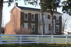 | Sylvester Marion and Frances Anne Stephens Baker House | building | 1999 | 99001018 |
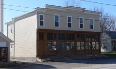 | Farmers Mercantile Co. Building | building | 2004 | 04000604 |
| Heinrich Gloe House | building | 2007 | 07000022 | |
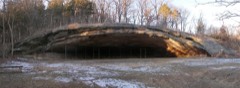 | Graham Cave | site | 1966 | 66000420 |
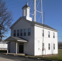 | High Hill School | building | 1980 | 80002381 |
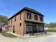 | McKittrick Farmers Mercantile | building | 2010 | 10000313 |
| Mount Horeb Baptist Church | building | 1980 | 80002382 | |
| Shrine of Our Lady of Sorrows | building | 1982 | 82003153 |
Every wildfire the federal occurrence database records inside this county: 33 of them, burning about 257 acres. None started naturally and none was recorded as arson. Each settlement page carries the fires within five miles of it.
| Reported cause | Fires |
|---|---|
| Missing data/not specified/undetermined | 14 |
| Debris and open burning | 13 |
| Equipment and vehicle use | 4 |
| Power generation/transmission/distribution | 1 |
| Smoking | 1 |
The five largest, by the area the report gives. None of them was recorded as arson.
| Date | Cause | Size | Reported by | Name on the report |
|---|---|---|---|---|
| 14 April 2016 | Debris and open burning | 112 acres | Missouri Department of Conservation | 135858-07034-04142016-1653 |
| 8 March 2020 | Debris and open burning | 63 acres | Missouri Department of Conservation | 190232-07003-03082020-1500 |
| 6 March 2018 | Debris and open burning | 13 acres | Missouri Department of Conservation | 176056-07003-03062018-1335 |
| 23 February 2018 | Power generation/transmission/distribution | 10 acres | Missouri Department of Conservation | 176054-07003-02232018-1845 |
| 7 March 2020 | Debris and open burning | 9.2 acres | Missouri Department of Conservation | 190311-07003-03072020-2105 |
| 19 February 2014 | Missing data/not specified/undetermined | 8.0 acres | Missouri Department of Conservation | not named |
| 31 March 2014 | Missing data/not specified/undetermined | 5.0 acres | Missouri Department of Conservation | not named |
| 12 March 1994 | Equipment and vehicle use | 4.0 acres | Missouri Department of Conservation | not named |
Every settlement page carries the fires within five miles of it - see the settlement index below.
The NOAA Storm Events Database holds 293 reports for this county, causing no deaths, 13 injuries and about $2,099,730 in recorded property damage. Each settlement page carries the reports that name it.
| Kind of event | Reports |
|---|---|
| Hail | 120 |
| Thunderstorm Wind | 114 |
| Flash Flood | 28 |
| Tornado | 25 |
| Flood | 4 |
| Funnel Cloud | 1 |
| Heavy Rain | 1 |
The most serious of them, by death, then injury, then recorded damage. The accounts are quoted exactly as the forecast office filed them.
| When | Event | Place named | Harm | What the report says |
|---|---|---|---|---|
| May 1980 | Tornado (F2) | not stated | 7 hurt, $250,000 | no account filed |
| December 1982 | Tornado (F1) | not stated | 2 hurt, $250,000 | no account filed |
| March 2006 | Tornado (F3) | Jonesburg | 1 hurt, $800,000 | The supercell thunderstorm that produced tornadoes in Osage, Callaway, and Montgomery counties produced another tornado in Montgomery County that formed in Jonesburg about Midnight CST March 13, 2006. Damage was first found on Highway Y where a home suffered roof damage. On West Boonslick Road a porta potty business suffered roof damage in addition to having about 20 porta potties destroyed, a few of which were missing. A garbage bin was blown about 100 yards into a field and a mobile home just north of the business was blown onto its side and destroyed. Damage in this area was rated F1 and was 100 yards wide. The tornado crossed Interstate 70 at mile marker 83 where it pushed a tractor-trailer off the highway. The tornado then produced damage as it crossed Highway E. Several homes suffered roof damage and several garage and barn type structures were destroyed. The tornado continued northeast and caused extensive damage as it crossed Oak Hall Road (County Road 250). The CC Pallet Company was destroyed and two mobile homes were destroyed. A 73 year old woman suffered broken bones and a back injury in one of the mobile homes. The tornado at this location was 200 yards wide and was rated F2. The tornado moved northeast causing tree damage as it moved across primarily open fields. Just north of Highway NN a new home was destroyed, tress were mangled and another home suffered roof damage. The tornado was rated F3 at this location and was 300 yards wide. The tornado next caused significant damage along Highway NN right at the Montgomery Warren County line about 12:10 am CST. A barn and several outbuildings were destroyed and a home suffered roof damage. The tornado was rated F1 and was about 100 yards wide at this location. The tornado then continued into Warren County. The Montgomery County Emergency Management Agency reported 8 structures destroyed, 10 with extensive damage and 14 with moderate damage. This covers homes and businesses and does not include barns and outbuildings. |
| June 1995 | Thunderstorm Wind | Wellsville | 1 hurt, $3,500 | A mobile home was heavily damaged west of Wellsville injuring a child inside. Numerous large trees were also knocked down near Montgomery City. Reported by a local newspaper. |
| June 2018 | Thunderstorm Wind | Danville | 1 hurt | Thunderstorm winds blew over a semi on eastbound Interstate 70 near mile marker 172. The driver sustained minor injuries. |
| June 2002 | Flash Flood | North Portion | 1 hurt | Heavy rain flooded numerous roads across the north part of Montgomery County. One car was swept off of Route W four miles south of Vandalia. A woman suffered minor injuries. |
| May 1980 | Tornado (F2) | not stated | $250,000 | no account filed |
| March 2006 | Tornado (F2) | Bellflower | $200,000 | A supercell thunderstorm produced a tornado that tracked from northeast Montgomery County, across northern Lincoln County, crossed into southeast Pike County, and then crossed the Mississippi River into Calhoun County, IL during the early morning hours of Monday, March 13, 2006. The total damage track was almost 45 miles with the tornado reaching a maximum damage width of 300 yards and a F3 rating. The tornado first formed and caused damage in northeast Montgomery County about 1:20 am CST along Union Chapel Road northwest of Bellflower. A home suffered roof damage with several trusses on the northwest side destroyed. The tornado was about 100 yards wide at this point and was rated F1. The tornado moved northeast and crossed Highway E several times. In the small community of Gamma, two homes suffered major roof damage, a barn and several outbuildings destroyed. The tornado was rated F2 at this location and was about 200 years wide. The tornado weakened and caused tree damage near the West Fork of the Cuivre River as it crossed into Lincoln County southwest of Olney. |
| July 2000 | Tornado (F1) | Bellflower | $75,000 | A tornado struck eastern Montgomery County causing damage at a farm and downing trees and power lines. The tornado first caused damage at a farm on Leonard Road which was also where the most extensive damage occurred. A large garage lost both doors and half of its roof. A grain trailer was overturned and 2 grain bins blown away, one to the northwest and the other about 1/2 mile to the east. The remainder of the damage path consisted of downed trees and crop damage. |
| October 2007 | Tornado (EF0) | Buell | $50,000 | The tornado touched down near the intersection of CR 165 and CR 168. It travelled to the northeast destroying one outbuilding and damaging or destroying numerous trees. Also, the southeast corner of a hog confinement building was damaged, leading to a partial roof collapse. Some of the debris was thrown a third of a mile to the northeast. An unoccupied car was also damaged. The tornado lifted and dissipated on CR 160 about a quarter of a mile south of CR 164. |
| May 2003 | Thunderstorm Wind | New Florence | $35,000 | Thunderstorm wind gusts damaged a greenhouse near New Florence. |
| December 2021 | Tornado (EF0) | Wellsville | $25,000 | A weak tornado touched down just northwest of Wellsville east of Highway 19 where it broke several power poles. It then moved northeast toward the intersection of Morgan School Road and Route A and traveled northeast to Orchard Road. Minor tree damage and flattened corn was observed. The width of the tornado was around 50 yards, and the damage was rated EF-0. Interestingly, the WSR-88D identified debris (lowering correlation coefficient), likely from the lofted corn stalks. Overall, the tornado was rated EF0 with a path length of 4.27miles and max path width of 50 yards. No deaths or injuries were reported. |
| July 1981 | Tornado (F2) | not stated | $25,000 | no account filed |
| April 1955 | Tornado (F2) | not stated | $25,000 | no account filed |
| April 1955 | Tornado (F2) | not stated | $25,000 | no account filed |
| July 1952 | Tornado (F1) | not stated | $25,000 | no account filed |
| May 2008 | Flash Flood | Montgomery City | $15,000 | Heavy rain flooded several county roads. Two people had to be rescued from a car trapped in flood water on Highway Y two miles east of Highway 19. |
| June 2022 | Thunderstorm Wind | Montgomery City | $10,000 | Numerous tree limbs blown down between Montgomery City and High Hill. Also, a large tree was blown down near Montgomery City, briefly blocking a road. |
| April 1995 | Hail | Danville | $5,500 | Nickel-size hail fell along Interstate 70 and caused numerous automobile accidents. A couple semi-trailer trucks ended up in the ditch. |
| June 2022 | Thunderstorm Wind | Big Spg | $5,000 | Thunderstorm winds blew down several trees onto Little Bear Creek Road just east of intersection with Highway 19. |
| October 2021 | Thunderstorm Wind | New Florence | $5,000 | Thunderstorm winds blew down several large trees in New Florence. |
| April 1994 | Thunderstorm Wind | Montgomery City | $5,000 | Several large trees and power lines were blown down. |
| May 1996 | Thunderstorm Wind | Montgomery City | $5,000 | no account filed |
| October 1995 | Thunderstorm Wind | Wellsville | $3,000 | Thunderstorm winds downed seven power poles in Wellsville, causing power outages in a large part of the city. |
| November 1995 | Thunderstorm Wind | Wellsville | $3,000 | Thunderstorm winds downed seven power poles in Wellsville, causing power outages in a large part of the city. |
| August 2021 | Thunderstorm Wind | Wellsville | $2,000 | Thunderstorm winds blew down a large tree limb onto power lines. Also, a street sign was blown over. |
| June 2013 | Flood | Mc Kittrick | $1,000 | no account filed |
| June 1995 | Thunderstorm Wind | Montgomery City | $600 | A mobile home was heavily damaged west of Wellsville injuring a child inside. Numerous large trees were also knocked down near Montgomery City. Reported by a local newspaper. |
| July 2007 | Thunderstorm Wind | Rhineland | $500 | Thunderstorm winds blew the tin roof off a barn and downed some large tree limbs. |
| July 1995 | Thunderstorm Wind | Montgomery City | $200 | The county sheriff reported power lines and numerous trees down with wind gusts as high as 70 mph. |
| April 1995 | Thunderstorm Wind | Montgomery City | $200 | The county sheriff reported several large trees down. |
| May 1995 | Thunderstorm Wind | Montgomery City | $200 | Ham radio spotters reported large trees down and minor street flooding. |
| April 1981 | Tornado (F0) | not stated | $30 | no account filed |
| May 2025 | Hail | Liege | - | Emergency management relayed a photo of a hailstone. |
| April 2025 | Thunderstorm Wind | Wellsville | - | Thunderstorm winds snapped a 2 foot diameter tree at its base. |
| March 2024 | Hail | Mc Kittrick | - | Large hail up to 2.50 inches was reported just north of McKittrick, just east of Big Spring and in Jonesburg. |
| March 2024 | Hail | High Hill | - | Hail up to golfball sized was reported along Interstate 70 in High Hill, MO. |
| June 2024 | Thunderstorm Wind | Wellsville | - | An amateur radio user reported 5 inch tree limbs down in Wellsville and no power in town. |
| April 2024 | Thunderstorm Wind | Wellsville | - | One medium sized tree was uprooted in Wellsville. |
| April 2024 | Hail | Americus | - | Loutre Valley Farm Guest House north of Rhineland reported lots of quarter sized hail fell at their location. |
| November 2024 | Tornado (EF0) | Liege | - | A brief, weak tornado formed along Baptist Rd in Montgomery County, tracking east-northeastward. The tornado did not impact any structures, but produced sporadic tree damage and lofted crop debris that was sampled by the KLSX radar. The tornado was rated EF-0 and had a path length of 1.87 miles and a max path width of 25 yards. No deaths or injuries were reported. |
| May 2023 | Flash Flood | Bluffton | - | Between 4 and 5 inches of rain fell in a short amount of time causing flash flooding across portions of southern Montgomery County. Approximately two feet of water was over Highway K from Dry Fork Creek, about two miles west northwest of Big Spring. |
| May 2023 | Thunderstorm Wind | New Florence | - | Thunderstorm winds snapped off a couple of power poles in town. Also, the winds blew off some shingles on several homes. |
| July 2023 | Thunderstorm Wind | Montgomery City | - | Thunderstorm winds blew down two trees, a flag pole and numerous tree limbs around town. |
| September 2023 | Hail | Ortiz | - | First responders in Rhineland reported quarter sized hail covering the ground as a thunderstorm split and intensified over the area. |
| August 2023 | Tornado (EF0) | Wellsville | - | The tornado touched down 5 miles southwest of Middletown, on the west side of Swope School Road, just north of intersection with Highway A. In this location, several trees and tree branches were blown down. The tornado moved to the southeast, crossing Highway A and then as it crossed Trinity Church Road, several large tree limbs were snapped off and blocked the road. The tornado continued to the southeast for almost two more miles with additional minor tree damage before lifting and dissipating near the intersection of Nagel Road and Poppy Road, about 4 miles south southwest of Middletown. Overall the tornado was rated EF0 with a path length of 2.54 miles and a max path width of 40 yards. No deaths or injuries were reported. |
| July 2023 | Thunderstorm Wind | Wellsville | - | Thunderstorm winds blew down numerous trees, tree limbs and power lines in Wellsville and Buell. One tree was blown down onto Highway 19 in Wellsville. |
| July 2023 | Thunderstorm Wind | Middletown | - | Observation taken with a handheld Kestrel Anemometer just west of Middletown. Gusts of 50-60 mph continued after the initial outflow moved through for approximately 20 minutes. |
| July 2023 | Thunderstorm Wind | High Hill | - | Thunderstorm winds blew down several power lines, causing a transformer to blow about a mile southeast of High Hill. |
| July 2022 | Flash Flood | Wellsville | - | Up to 7 inches of rain fell in a 6 to 10 hour period causing flash flooding. Numerous roads were flooded across the northern half of the county, including Highway 19 just south of Wellsville, Route 161 between Buell and Route V, Route CC near White Oak Road, and Route E between Kneubuhler Road and Pine Knot Road. No injuries were reported. |
| May 2022 | Flash Flood | Liege | - | Up to three inches of rain fell in a short amount of time causing flash flooding. State Highway E was flooded in several locations between Bellflower and Jonesburg. |
| June 2021 | Thunderstorm Wind | Montgomery City | - | A large tree was blown down on West 6th Street in Montgomery City. |
| June 2021 | Flash Flood | Bluffton | - | Up to five inches of rain fell in about a 6 hour period causing flash flooding. Several roads were flooded including Highway 94 near Rhineland. |
| March 2020 | Hail | Americus | - | Large hail up to baseball size was reported in southern portions of Montgomery County, including in the Big Spring area. |
| July 2020 | Flash Flood | Mc Kittrick | - | Up to four inches of rain fell in a short amount of time causing flash flooding. Several roads were flooded including Highway 94 near Rhineland. |
| May 2020 | Thunderstorm Wind | Middletown | - | Thunderstorm winds caused minor damage to several out buildings and tore up a section of fencing. |
| August 2020 | Thunderstorm Wind | Bellflower | - | Thunderstorm winds blew down several tree limbs around town. |
| August 2019 | Flash Flood | Danville | - | Up to five inches of rain fell in a short amount of time causing flash flooding, mainly along and south of Interstate 70 in Montgomery County. Numerous roads were flooded including portions of the south outer road along I-70 near mile marker 186. MODOT closed Route K between Route HH and State Highway 19 due to flash flooding. They also closed Route Y east of State Highway 19 just east of Big Spring. |
| May 2019 | Thunderstorm Wind | Jonesburg | - | Thunderstorm winds blew down a couple of trees in Jonesburg and snapped a power pole off along I-70 near mile marker 186. |
| May 2018 | Thunderstorm Wind | Montgomery City | - | Thunderstorm winds blew down several trees and power lines. In Bellflower, a pole barn was blown down and a nearby home sustained minor roof damage. |
The Survey's mineral resources record lists 253 workings inside this county. 4 still produce and 249 are closed or unrecorded. Each settlement page carries the workings within five miles of it.
| Commodity | Workings |
|---|---|
| Fire Clay (Refractory) | 220 |
| Stone, Crushed/Broken | 25 |
| Sand and Gravel, Construction | 6 |
| Limestone, Dimension | 1 |
| Clay | 1 |
The least common of them first, because a county's hundredth gravel pit says nothing its first ten did not.
| Where | Site | Commodity | Status | Recorded |
|---|---|---|---|---|
| Missouri Minerals Processing Plant | Clay | Producer | ||
| Unknown - Ls-Dm. | Limestone, Dimension | Past Producer | ||
| Hermann Sand & Gravel Dredge | Sand and Gravel, Construction | Producer | ||
| Unknown - Gravel | Sand and Gravel, Construction | Past Producer | ||
| Unknown - Gravel | Sand and Gravel, Construction | Past Producer | ||
| Unknown - Sand | Sand and Gravel, Construction | Past Producer | ||
| Unknown - Sand & Gravel | Sand and Gravel, Construction | Past Producer | ||
| Unknown - Sand & Gravel | Sand and Gravel, Construction | Past Producer | ||
| Big Spring Quarry & Plant | Stone, Crushed/Broken | Producer | ||
| Green Quarry | Stone, Crushed/Broken | Past Producer | ||
| Mcclain Lime Quarry & Plant | Stone, Crushed/Broken | Producer | ||
| Mcclain Quarry | Stone, Crushed/Broken | Past Producer | ||
| Unknown - Ls. | Stone, Crushed/Broken | Past Producer | ||
| Unknown - Ls. | Stone, Crushed/Broken | Past Producer | ||
| Unknown - Ls. | Stone, Crushed/Broken | Past Producer | ||
| Unknown - Ls. | Stone, Crushed/Broken | Past Producer | ||
| Unknown - Ls. | Stone, Crushed/Broken | Past Producer | ||
| Unknown - Ls. | Stone, Crushed/Broken | Past Producer | ||
| Unknown - Ls. | Stone, Crushed/Broken | Past Producer | ||
| Unknown - Ls. | Stone, Crushed/Broken | Past Producer | ||
| Unknown - Ls. | Stone, Crushed/Broken | Past Producer | ||
| Unknown - Ls. | Stone, Crushed/Broken | Past Producer | ||
| Unknown - Ls. | Stone, Crushed/Broken | Past Producer | ||
| Unknown - Ls. | Stone, Crushed/Broken | Past Producer | ||
| Unknown - Ls. | Stone, Crushed/Broken | Past Producer | ||
| Unknown - Ls. | Stone, Crushed/Broken | Past Producer | ||
| Unknown - Ls. | Stone, Crushed/Broken | Past Producer | ||
| Unknown - Ls. | Stone, Crushed/Broken | Past Producer | ||
| Unknown - Ls. | Stone, Crushed/Broken | Past Producer | ||
| Unknown - Ls. | Stone, Crushed/Broken | Past Producer | ||
| Unknown - Ls. | Stone, Crushed/Broken | Past Producer | ||
| Zumsteg Quarry | Stone, Crushed/Broken | Past Producer | ||
| Zumsteg Quarry | Stone, Crushed/Broken | Unknown | ||
| A.P. Green Pit | Fire Clay (Refractory) | Past Producer | ||
| Ammann Pits | Fire Clay (Refractory) | Past Producer | ||
| Anderson Pit | Fire Clay (Refractory) | Past Producer | ||
| Bratton Pit | Fire Clay (Refractory) | Past Producer | ||
| Brown Pit | Fire Clay (Refractory) | Past Producer | ||
| Capstix Pit | Fire Clay (Refractory) | Past Producer | ||
| Case Pit | Fire Clay (Refractory) | Past Producer | ||
| Chris Haerer | Fire Clay (Refractory) | Past Producer | ||
| Christy Pit | Fire Clay (Refractory) | Past Producer | ||
| E.H. Higgins Pit | Fire Clay (Refractory) | Past Producer | ||
| Flint Pit | Fire Clay (Refractory) | Past Producer | ||
| Green Pit | Fire Clay (Refractory) | Past Producer | ||
| Hydraulic Press Brick Pit | Fire Clay (Refractory) | Past Producer | ||
| J.H.Brown Pit | Fire Clay (Refractory) | Past Producer | ||
| J.H.Zweitel Pit | Fire Clay (Refractory) | Past Producer | ||
| Kelsie Bank | Fire Clay (Refractory) | Past Producer | ||
| Laclede Christy Pit | Fire Clay (Refractory) | Past Producer | ||
| Madin Pit | Fire Clay (Refractory) | Past Producer | ||
| Max Walther | Fire Clay (Refractory) | Past Producer | ||
| Moore Pit | Fire Clay (Refractory) | Past Producer | ||
| Parker-Russell | Fire Clay (Refractory) | Past Producer | ||
| Steward Dent Pits | Fire Clay (Refractory) | Unknown | ||
| Unknown - Clay | Fire Clay (Refractory) | Past Producer | ||
| Unknown - Clay | Fire Clay (Refractory) | Past Producer | ||
| Unknown - Clay | Fire Clay (Refractory) | Past Producer | ||
| Unknown - Clay | Fire Clay (Refractory) | Past Producer | ||
| Unknown - Clay | Fire Clay (Refractory) | Past Producer | ||
| Unknown - Clay | Fire Clay (Refractory) | Past Producer | ||
| Unknown - Clay | Fire Clay (Refractory) | Past Producer | ||
| Unknown - Clay | Fire Clay (Refractory) | Past Producer | ||
| Unknown - Clay | Fire Clay (Refractory) | Past Producer | ||
| Unknown - Clay | Fire Clay (Refractory) | Past Producer | ||
| Unknown - Clay | Fire Clay (Refractory) | Past Producer | ||
| Unknown - Clay | Fire Clay (Refractory) | Past Producer | ||
| Unknown - Clay | Fire Clay (Refractory) | Past Producer | ||
| Unknown - Clay | Fire Clay (Refractory) | Past Producer | ||
| Unknown - Clay | Fire Clay (Refractory) | Past Producer | ||
| Unknown - Clay | Fire Clay (Refractory) | Past Producer | ||
| Unknown - Clay | Fire Clay (Refractory) | Past Producer | ||
| Unknown - Clay | Fire Clay (Refractory) | Past Producer | ||
| Unknown - Clay | Fire Clay (Refractory) | Past Producer | ||
| Unknown - Clay | Fire Clay (Refractory) | Past Producer | ||
| Unknown - Clay | Fire Clay (Refractory) | Past Producer | ||
| Unknown - Clay | Fire Clay (Refractory) | Past Producer | ||
| Unknown - Clay | Fire Clay (Refractory) | Past Producer | ||
| Unknown - Clay | Fire Clay (Refractory) | Past Producer | ||
| Unknown - Clay | Fire Clay (Refractory) | Past Producer | ||
| Unknown - Clay | Fire Clay (Refractory) | Past Producer | ||
| Unknown - Clay | Fire Clay (Refractory) | Past Producer | ||
| Unknown - Clay | Fire Clay (Refractory) | Past Producer | ||
| Unknown - Clay | Fire Clay (Refractory) | Past Producer | ||
| Unknown - Clay | Fire Clay (Refractory) | Past Producer | ||
| Unknown - Clay | Fire Clay (Refractory) | Past Producer | ||
| Unknown - Clay | Fire Clay (Refractory) | Past Producer | ||
| Unknown - Clay | Fire Clay (Refractory) | Past Producer | ||
| Unknown - Clay | Fire Clay (Refractory) | Past Producer | ||
| Unknown - Clay | Fire Clay (Refractory) | Past Producer | ||
| Unknown - Clay | Fire Clay (Refractory) | Past Producer | ||
| Unknown - Clay | Fire Clay (Refractory) | Past Producer | ||
| Unknown - Clay | Fire Clay (Refractory) | Past Producer | ||
| Unknown - Clay | Fire Clay (Refractory) | Past Producer | ||
| Unknown - Clay | Fire Clay (Refractory) | Past Producer | ||
| Unknown - Clay | Fire Clay (Refractory) | Past Producer | ||
| Unknown - Clay | Fire Clay (Refractory) | Past Producer | ||
| Unknown - Clay | Fire Clay (Refractory) | Past Producer | ||
| Unknown - Clay | Fire Clay (Refractory) | Past Producer | ||
| Unknown - Clay | Fire Clay (Refractory) | Past Producer | ||
| Unknown - Clay | Fire Clay (Refractory) | Past Producer | ||
| Unknown - Clay | Fire Clay (Refractory) | Past Producer | ||
| Unknown - Clay | Fire Clay (Refractory) | Past Producer | ||
| Unknown - Clay | Fire Clay (Refractory) | Past Producer | ||
| Unknown - Clay | Fire Clay (Refractory) | Past Producer | ||
| Unknown - Clay | Fire Clay (Refractory) | Past Producer | ||
| Unknown - Clay | Fire Clay (Refractory) | Past Producer | ||
| Unknown - Clay | Fire Clay (Refractory) | Past Producer | ||
| Unknown - Clay | Fire Clay (Refractory) | Past Producer | ||
| Unknown - Clay | Fire Clay (Refractory) | Unknown | ||
| Unknown - Clay | Fire Clay (Refractory) | Past Producer | ||
| Unknown - Clay | Fire Clay (Refractory) | Past Producer | ||
| Unknown - Clay | Fire Clay (Refractory) | Past Producer | ||
| Unknown - Clay | Fire Clay (Refractory) | Past Producer | ||
| Unknown - Clay | Fire Clay (Refractory) | Past Producer | ||
| Unknown - Clay | Fire Clay (Refractory) | Past Producer | ||
| Unknown - Clay | Fire Clay (Refractory) | Past Producer | ||
| Unknown - Clay | Fire Clay (Refractory) | Past Producer | ||
| Unknown - Clay | Fire Clay (Refractory) | Past Producer | ||
| Unknown - Clay | Fire Clay (Refractory) | Past Producer | ||
| Unknown - Clay | Fire Clay (Refractory) | Past Producer | ||
| Unknown - Clay | Fire Clay (Refractory) | Past Producer | ||
| Unknown - Clay | Fire Clay (Refractory) | Past Producer | ||
| Unknown - Clay | Fire Clay (Refractory) | Past Producer | ||
| Unknown - Clay | Fire Clay (Refractory) | Past Producer | ||
| Unknown - Clay | Fire Clay (Refractory) | Past Producer | ||
| Unknown - Clay | Fire Clay (Refractory) | Past Producer | ||
| Unknown - Clay | Fire Clay (Refractory) | Past Producer | ||
| Unknown - Clay | Fire Clay (Refractory) | Past Producer | ||
| Unknown - Clay | Fire Clay (Refractory) | Past Producer | ||
| Unknown - Clay | Fire Clay (Refractory) | Past Producer | ||
| Unknown - Clay | Fire Clay (Refractory) | Past Producer | ||
| Unknown - Clay | Fire Clay (Refractory) | Past Producer | ||
| Unknown - Clay | Fire Clay (Refractory) | Past Producer | ||
| Unknown - Clay | Fire Clay (Refractory) | Past Producer | ||
| Unknown - Clay | Fire Clay (Refractory) | Past Producer | ||
| Unknown - Clay | Fire Clay (Refractory) | Past Producer | ||
| Unknown - Clay | Fire Clay (Refractory) | Past Producer | ||
| Unknown - Clay | Fire Clay (Refractory) | Past Producer | ||
| Unknown - Clay | Fire Clay (Refractory) | Past Producer | ||
| Unknown - Clay | Fire Clay (Refractory) | Past Producer | ||
| Unknown - Clay | Fire Clay (Refractory) | Past Producer | ||
| Unknown - Clay | Fire Clay (Refractory) | Past Producer | ||
| Unknown - Clay | Fire Clay (Refractory) | Past Producer | ||
| Unknown - Clay | Fire Clay (Refractory) | Past Producer | ||
| Unknown - Clay | Fire Clay (Refractory) | Past Producer | ||
| Unknown - Clay | Fire Clay (Refractory) | Past Producer | ||
| Unknown - Clay | Fire Clay (Refractory) | Past Producer | ||
| Unknown - Clay | Fire Clay (Refractory) | Past Producer | ||
| Unknown - Clay | Fire Clay (Refractory) | Past Producer | ||
| Unknown - Clay | Fire Clay (Refractory) | Past Producer | ||
| Unknown - Clay | Fire Clay (Refractory) | Past Producer | ||
| Unknown - Clay | Fire Clay (Refractory) | Past Producer | ||
| Unknown - Clay | Fire Clay (Refractory) | Past Producer | ||
| Unknown - Clay | Fire Clay (Refractory) | Past Producer | ||
| Unknown - Clay | Fire Clay (Refractory) | Past Producer | ||
| Unknown - Clay | Fire Clay (Refractory) | Past Producer | ||
| Unknown - Clay | Fire Clay (Refractory) | Past Producer | ||
| Unknown - Clay | Fire Clay (Refractory) | Past Producer | ||
| Unknown - Clay | Fire Clay (Refractory) | Past Producer | ||
| Unknown - Clay | Fire Clay (Refractory) | Past Producer | ||
| Unknown - Clay | Fire Clay (Refractory) | Past Producer | ||
| Unknown - Clay | Fire Clay (Refractory) | Past Producer | ||
| Unknown - Clay | Fire Clay (Refractory) | Past Producer | ||
| Unknown - Clay | Fire Clay (Refractory) | Past Producer | ||
| Unknown - Clay | Fire Clay (Refractory) | Past Producer | ||
| Unknown - Clay | Fire Clay (Refractory) | Past Producer | ||
| Unknown - Clay | Fire Clay (Refractory) | Past Producer | ||
| Unknown - Clay | Fire Clay (Refractory) | Past Producer | ||
| Unknown - Clay | Fire Clay (Refractory) | Past Producer | ||
| Unknown - Clay | Fire Clay (Refractory) | Past Producer | ||
| Unknown - Clay | Fire Clay (Refractory) | Past Producer | ||
| Unknown - Clay | Fire Clay (Refractory) | Past Producer | ||
| Unknown - Clay | Fire Clay (Refractory) | Past Producer | ||
| Unknown - Clay | Fire Clay (Refractory) | Past Producer | ||
| Unknown - Clay | Fire Clay (Refractory) | Past Producer | ||
| Unknown - Clay | Fire Clay (Refractory) | Past Producer | ||
| Unknown - Clay | Fire Clay (Refractory) | Past Producer | ||
| Unknown - Clay | Fire Clay (Refractory) | Past Producer | ||
| Unknown - Clay | Fire Clay (Refractory) | Past Producer | ||
| Unknown - Clay | Fire Clay (Refractory) | Past Producer | ||
| Unknown - Clay | Fire Clay (Refractory) | Past Producer | ||
| Unknown - Clay | Fire Clay (Refractory) | Past Producer | ||
| Unknown - Clay | Fire Clay (Refractory) | Past Producer | ||
| Unknown - Clay | Fire Clay (Refractory) | Past Producer | ||
| Unknown - Clay | Fire Clay (Refractory) | Past Producer | ||
| Unknown - Clay | Fire Clay (Refractory) | Past Producer | ||
| Unknown - Clay | Fire Clay (Refractory) | Past Producer | ||
| Unknown - Clay | Fire Clay (Refractory) | Past Producer | ||
| Unknown - Clay | Fire Clay (Refractory) | Past Producer | ||
| Unknown - Clay | Fire Clay (Refractory) | Past Producer | ||
| Unknown - Clay | Fire Clay (Refractory) | Past Producer | ||
| Unknown - Clay | Fire Clay (Refractory) | Past Producer | ||
| Unknown - Clay | Fire Clay (Refractory) | Past Producer | ||
| Unknown - Clay | Fire Clay (Refractory) | Past Producer | ||
| Unknown - Clay | Fire Clay (Refractory) | Past Producer | ||
| Unknown - Clay | Fire Clay (Refractory) | Past Producer | ||
| Unknown - Clay | Fire Clay (Refractory) | Past Producer | ||
| Unknown - Clay | Fire Clay (Refractory) | Past Producer | ||
| Unknown - Clay | Fire Clay (Refractory) | Past Producer | ||
| Unknown - Clay | Fire Clay (Refractory) | Past Producer | ||
| Unknown - Clay | Fire Clay (Refractory) | Past Producer | ||
| Unknown - Clay | Fire Clay (Refractory) | Past Producer | ||
| Unknown - Clay | Fire Clay (Refractory) | Past Producer | ||
| Unknown - Clay | Fire Clay (Refractory) | Past Producer | ||
| Unknown - Clay | Fire Clay (Refractory) | Past Producer | ||
| Unknown - Clay | Fire Clay (Refractory) | Past Producer | ||
| Unknown - Clay | Fire Clay (Refractory) | Past Producer | ||
| Unknown - Clay | Fire Clay (Refractory) | Past Producer | ||
| Unknown - Clay | Fire Clay (Refractory) | Past Producer | ||
| Unknown - Clay | Fire Clay (Refractory) | Past Producer | ||
| Unknown - Clay | Fire Clay (Refractory) | Past Producer | ||
| Unknown - Clay | Fire Clay (Refractory) | Past Producer | ||
| Unknown - Clay | Fire Clay (Refractory) | Past Producer | ||
| Unknown - Clay | Fire Clay (Refractory) | Past Producer | ||
| Unknown - Clay | Fire Clay (Refractory) | Past Producer | ||
| Unknown - Clay | Fire Clay (Refractory) | Past Producer | ||
| Unknown - Clay | Fire Clay (Refractory) | Past Producer | ||
| Unknown - Clay | Fire Clay (Refractory) | Past Producer | ||
| Unknown - Clay | Fire Clay (Refractory) | Past Producer | ||
| Unknown - Clay | Fire Clay (Refractory) | Past Producer | ||
| Unknown - Clay | Fire Clay (Refractory) | Past Producer | ||
| Unknown - Clay | Fire Clay (Refractory) | Past Producer | ||
| Unknown - Clay | Fire Clay (Refractory) | Past Producer | ||
| Unknown - Clay | Fire Clay (Refractory) | Past Producer | ||
| Unknown - Clay | Fire Clay (Refractory) | Past Producer | ||
| Unknown - Clay | Fire Clay (Refractory) | Past Producer | ||
| Unknown - Clay | Fire Clay (Refractory) | Past Producer | ||
| Unknown - Clay | Fire Clay (Refractory) | Past Producer | ||
| Unknown - Clay | Fire Clay (Refractory) | Past Producer | ||
| Unknown - Clay | Fire Clay (Refractory) | Past Producer | ||
| Unknown - Clay | Fire Clay (Refractory) | Past Producer | ||
| Unknown - Clay | Fire Clay (Refractory) | Past Producer | ||
| Unknown - Clay | Fire Clay (Refractory) | Past Producer | ||
| Unknown - Clay | Fire Clay (Refractory) | Past Producer | ||
| Unknown - Clay | Fire Clay (Refractory) | Past Producer | ||
| Unknown - Clay | Fire Clay (Refractory) | Past Producer | ||
| Unknown - Clay | Fire Clay (Refractory) | Past Producer | ||
| Unknown - Clay | Fire Clay (Refractory) | Past Producer | ||
| Unknown - Clay | Fire Clay (Refractory) | Past Producer | ||
| Unknown - Clay | Fire Clay (Refractory) | Past Producer | ||
| Unknown - Clay | Fire Clay (Refractory) | Past Producer | ||
| Unknown - Clay | Fire Clay (Refractory) | Past Producer | ||
| Unknown - Clay | Fire Clay (Refractory) | Past Producer | ||
| Unknown - Clay | Fire Clay (Refractory) | Past Producer | ||
| Unknown - Clay | Fire Clay (Refractory) | Past Producer | ||
| Unknown - Clay | Fire Clay (Refractory) | Past Producer | ||
| Unknown - Clay | Fire Clay (Refractory) | Past Producer | ||
| Unknown - Clay | Fire Clay (Refractory) | Past Producer | ||
| Unknown - Clay | Fire Clay (Refractory) | Past Producer | ||
| Unknown - Clay | Fire Clay (Refractory) | Past Producer | ||
| Unknown - Clay | Fire Clay (Refractory) | Past Producer | ||
| Weeks Pit | Fire Clay (Refractory) | Past Producer |
History of St.charles, Montgomery and Warren Counties, Missouri devotes a chapter to each township: its boundaries and streams, who settled it and when, the mills, the schools and the churches. The one chapter is reproduced here in full. Each row shows the township's own shape and where it lies in the county, drawn from the Census Bureau's boundary. Which settlements belong to which township is computed from that same boundary, not taken from the book.
| Shape and position in the county | Township | Settlements in it | Length | Sections |
|---|---|---|---|---|
| Upper Loutre Township | Wellsville | 222 words | 6 |
One book written about this county, cut here where the book itself is cut, at its printed chapters: 4 chapters in all. Every chapter is public domain, machine-read from the scan and reproduced complete. A chapter already given under one of the county's towns is not repeated in this list.
| Chapter | Length |
|---|---|
| Biographical sketches (1 of 2 so headed) | 38,536 words in 3 parts |
| Leading Events of 1861 | 24,176 words in 2 parts |
| Miscellaneous Events from 1870 to 1884 | 7,775 words |
| Biographical sketches (2 of 2 so headed) | 122,206 words in 8 parts |
Named settlements recorded in the Geographic Names Information System, each with the topographic sheets covering it. Villages, hamlets and abandoned places alike. Each is shown with the nearest named watercourse or landform and the survey quadrangle it falls on.
Loutre township · 63363 · On Mill Creek · Pinnacle Lake quadrangle
21 sheets, 1890 to 1985
Loutre township · 65069 · On Synthianna Creek · Gasconade quadrangle
21 sheets, 1890 to 1985
Prairie township · 63333 · On Long Branch · Bellflower North quadrangle
16 sheets, 1890 to 1986
Prairie township · 63359 · On Crooked Creek · Middletown quadrangle
16 sheets, 1890 to 1986
Danville township · 63361 · On Sallee Branch · Montgomery City quadrangle
21 sheets, 1890 to 1985
Bear Creek township · 63363 · On Prices Branch · Bellflower South quadrangle
20 sheets, 1890 to 1985