 Block
From the record
5 National Register listings published here.
Sources: the National Register database, National Park Service
87 topographic sheets cover 19 settlements here, and 5 properties are on the National Register of Historic Places.
5 National Register listings published here.
Sources: the National Register database, National Park Service
Every property in this county listed on the National Register of Historic Places, with the year it was listed and the federal nomination document.
| Photograph | Property | Type | Listed | Reference |
|---|---|---|---|---|
| Martin Hotel | building | 1978 | 78001669 | |
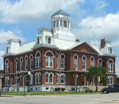 | Morgan County Courthouse | building | 1980 | 80002383 |
| Old St. Patrick's Church | building | 1979 | 79001384 | |
| Jesse Ratcliff House | building | 1982 | 82003154 | |
| Second Baptist Church and Booker T. Washington School Historic District | district | 2020 | 100005348 |
Every wildfire the federal occurrence database records inside this county: 491 of them, burning about 7,981 acres. 1 started naturally and 94 were recorded as arson. Each settlement page carries the fires within five miles of it.
| Reported cause | Fires |
|---|---|
| Debris and open burning | 237 |
| Missing data/not specified/undetermined | 136 |
| Arson/incendiarism | 94 |
| Equipment and vehicle use | 13 |
| Smoking | 7 |
| Misuse of fire by a minor | 2 |
| Fireworks | 1 |
| Natural | 1 |
The five largest, by the area the report gives. Three of them were set deliberately.
| Date | Cause | Size | Reported by | Name on the report |
|---|---|---|---|---|
| 27 February 2006 | Missing data/not specified/undetermined | 745 acres | Missouri Department of Conservation | HOLLOW FIRE |
| 7 September 1999 | Debris and open burning | 563 acres | Missouri Department of Conservation | not named |
| 12 March 1995 | Debris and open burning | 365 acres | Missouri Department of Conservation | not named |
| 26 March 2012 | Missing data/not specified/undetermined | 300 acres | Missouri Department of Conservation | CUP TREE |
| 6 November 1999 | Arson/incendiarism | 238 acres | Missouri Department of Conservation | not named |
| 12 April 2001 | Arson/incendiarism | 167 acres | Missouri Department of Conservation | not named |
| 10 April 2019 | Missing data/not specified/undetermined | 154 acres | Missouri Department of Conservation | 178689-07140-04102019-1618 |
| 28 August 1999 | Arson/incendiarism | 152 acres | Missouri Department of Conservation | not named |
Every settlement page carries the fires within five miles of it - see the settlement index below.
The NOAA Storm Events Database holds 552 reports for this county, causing 1 death, 7 injuries and about $5,679,640 in recorded property damage. Each settlement page carries the reports that name it.
| Kind of event | Reports |
|---|---|
| Hail | 196 |
| Thunderstorm Wind | 182 |
| Flash Flood | 92 |
| Flood | 35 |
| Tornado | 31 |
| Heavy Rain | 8 |
| Funnel Cloud | 5 |
| Lightning | 2 |
| Wildfire | 1 |
The most serious of them, by death, then injury, then recorded damage. The accounts are quoted exactly as the forecast office filed them.
| When | Event | Place named | Harm | What the report says |
|---|---|---|---|---|
| July 1996 | Flash Flood | Florence | 1 killed, $5,000 | no account filed |
| March 2006 | Tornado (F2) | Gravois Mills | 5 hurt, $850,000 | A tornado initially touched down southwest of Gravois Mills and tracked through the city. 20 homes were destroyed while another 10 were damaged. This tornado was spawned from the same cyclic supercell that produced tornadoes back in Hickory, Polk, Dade, and Barton counties. |
| May 1954 | Tornado (F2) | not stated | 2 hurt, $25,000 | no account filed |
| December 2015 | Flood | Gravois Mills | $500,000 | Several low water crossings were flooded and several rural roads had damage due to flood waters. This storm report will contain the damage estimates for the entire county for this event. |
| April 1994 | Thunderstorm Wind | Versailles | $500,000 | A line of severe thunderstorms produced widespread wind damage and several reports of hail. Power lines and numerous trees were blown down. Many wooden and a few tin barns lost parts of their walls or roof. A few barns were pushed partially off their foundations. Near Versailles, an aviation hangar and two small planes at a private airstrip were damaged. Several houses in town sustain damage to shingles. |
| April 1994 | Thunderstorm Wind | Barnett | $500,000 | Two 500-foot turkey buildings were almost completely destroyed. On the south side of town, strong winds toppled an entire fence row of mature trees. Minor damage to mobile homes was also reported. |
| July 2023 | Hail | Stover | $250,000 | Hail up to tennis balls in size was reported in downtown Stover. Vehicles and roof damage occurred. |
| March 1982 | Tornado (F2) | not stated | $250,000 | no account filed |
| March 1961 | Tornado (F2) | not stated | $250,000 | no account filed |
| March 1961 | Tornado (F2) | not stated | $250,000 | no account filed |
| April 1995 | Tornado (F1) | Gravois Mills | $175,000 | A tornado touched down briefly between one and two miles east of Gravois Mills near the 6.5 mile marker along the Gravois Arm of the Lake Of The Ozarks. A report made by an officer of the Missouri State Water Patrol indicated that the tornado turned over 20 boat docks and damaged or sank between 20 and 25 boats. At least one house was damaged and eyewitnesses said that trees were uprooted with some of the debris left floating on the water. The length and width of the tornado were estimated based on damage reports. |
| April 2026 | Hail | Glensted | $150,000 | Hail up to 3 inches in diameter was reported in a mainly rural area. A home and several barns had roof damage and a few vehicles were damaged. |
| July 1995 | Thunderstorm Wind | Versailles | $140,000 | A severe thunderstorm produced a two to three mile wide swath of scattered wind damage and hail from two miles northwest of Excelsior to six miles southwest of Excelsior. Strong winds damaged 23 farm buildings, while a combination of wind and hail damaged crops. |
| May 2025 | Thunderstorm Wind | Versailles | $130,000 | Multiple trees and power lines were reported to be down. Additionally, a lightning strike caused a house fire, and a nearby machine shop suffered heavy damage. |
| June 2025 | Thunderstorm Wind | Gravois Mills Arpt | $100,000 | Thunderstorm wind gusts of at least 70 mph downed numerous trees in the Gravois Mills and Laurie areas. Some trees landed on homes. |
| March 2017 | Tornado (EF0) | Rocky Mt | $100,000 | An EF-0 tornado damaged some outbuildings and docks south of Rocky Mount in Morgan County. Maximum wind speed was estimated 75 to 85 mph. |
| April 2017 | Flood | Gravois Mills | $100,000 | Several roads sustained flood damage across the county. This report will contain the total dollar estimate for flood damage to infrastructure, businesses, and homes across Morgan County. |
| April 2026 | Thunderstorm Wind | Rocky Mt | $50,000 | Power lines were reported down on Oak Road. |
| April 2026 | Lightning | Versailles | $50,000 | A home was struck by lightning causing a structure fire on the south side of Versailles. |
| April 2026 | Tornado (EF1) | Zwanzig | $50,000 | A combination of ground National Weather Service surveys and Sentinel-2 satellite data concluded an EF1 tornado occurred 2 miles north of Gravois Mills. Several trees were uprooted in a cyclonic pattern and multiple other trees and limbs were damaged along the tornado's path. A window on a home was broken and two outbuildings suffered damage. Along the slightly over 7 mile track of the tornado maximum winds were 90mph with a width of 300 yards. |
| May 2017 | Tornado (EF1) | Gravois Mills Arpt | $50,000 | A NWS storm survey confirmed an EF-1 tornado briefly touched down approximately one mile north of Sunrise Beach. Estimated maximum wind speeds were up to 90 mph. Numerous trees were uprooted. |
| April 2016 | Hail | Stover | $50,000 | Golf ball size hail was reported at Highway 135 and Elhers Road just north of Stover, Missouri. A few cars and windows were damaged. This storm report will include the damage cost estimates for the entire county with this event. |
| April 2014 | Thunderstorm Wind | Gravois Mills Arpt | $50,000 | Several trees were blown onto a house and trailer. A boat dock had minor damage. |
| May 2013 | Tornado (EF0) | Gravois Mills | $50,000 | An EF-0 tornado briefly touched down about 3 miles west-northwest of Gravois Mills uprooting numerous trees and causing minor structural damage. The winds were estimated between 70 to 80 mph. |
| July 2011 | Thunderstorm Wind | Rocky Mt | $50,000 | One boat dock was destroyed and minor damage was reported to several boats. A few trees were blown down. |
| July 2004 | Thunderstorm Wind | Countywide | $50,000 | A derecho that swept across west central and central Missouri caused intermittent damage across Morgan County. Numerous trees and power lines were downed, along with minor damage to several structures. |
| April 1994 | Thunderstorm Wind | Stover | $50,000 | A house near the intersection of Highways 135 and 52 had its porch roof ripped off and blown into a tree next to the house. Several other houses had shingles blown off and television antennas bent. |
| June 1994 | Hail | Laurie | $50,000 | Large hail damaged area crops and wind gusts knocked down large trees south of Versailles. |
| March 1993 | Hail | Versailles | $50,000 | The Morgan County Sheriff's Office reported lightning started a house fire. |
| April 2024 | Flash Flood | Barnett | $40,000 | Hillpoint Road was flooded and impassable at a low water crossing of a tributary of Indian Creek. Law enforcement indicated that the fast flowing water washed out or damaged the bridge across the creek. |
| April 2026 | Thunderstorm Wind | Stover | $30,000 | Power lines were reported down. |
| April 1999 | Thunderstorm Wind | Gravois Mills | $30,000 | no account filed |
| June 2019 | Hail | Florence | $25,000 | Golf ball sized hail was reported in Florence. Minor roof and car damage occurred. |
| May 2017 | Tornado (EF1) | Gravois Mills Arpt | $25,000 | A NWS storm survey team confirmed an EF-1 tornado briefly touched down approximately 2 miles north-northeast of Sunrise Beach. Numerous trees were uprooted. There was damage to a roof of a metal building. Estimated maximum wind speeds were up to 90 mph. |
| June 2015 | Flash Flood | Gravois Mills | $25,000 | A portion of Highway 5 in Gravois Mills was flooded. This storm report will contain the overall storm damage estimates across the entire Morgan County for this storm event. Several roads, bridges, and low water crossings were damaged. |
| June 2008 | Flash Flood | Gravois Mills | $25,000 | A creek that flows near downtown Gravois Mills flooded streets and store fronts. |
| June 2004 | Thunderstorm Wind | Stover | $25,000 | A squall line downed numerous powerlines and trees from Stover to Versailles. |
| April 1978 | Tornado | not stated | $25,000 | no account filed |
| May 1954 | Tornado (F2) | not stated | $25,000 | no account filed |
| April 2025 | Tornado (EF0) | Aikinsville | $20,000 | A National Weather Service survey found that an EF-0 A tornado touched down south of Mill Creek in Morgan County, Missouri at 4:30 PM on April 20, 2025. This tornado removed multiple turkey/chicken barn roof panels, in addition to breaking several large tree limbs. The tornado lifted at 4:32 PM. |
| June 2025 | Thunderstorm Wind | Rocky Mt | $20,000 | Thunderstorm wind gusts downed trees and damaged the roof of a home near Rocky Mount. |
| March 2024 | Thunderstorm Wind | Excelsior | $20,000 | A building sustained heavy roof damage off of Highway C north of Barnett. |
| May 2024 | Hail | Gravois Mills Arpt | $20,000 | Report of tennis ball size hail. |
| August 2019 | Flash Flood | Versailles Otten Arp | $20,000 | Willowcreek Road near Highway D, at Straight Fork, had 10 feet of road washed out as a culvert lifted from flood waters. |
| May 2017 | Thunderstorm Wind | Gravois Mills | $20,000 | There were pictures from social media of a large tree blown down on to a mobile home. There were power lines blown down as well. |
| September 2009 | Flood | Gravois Mills | $20,000 | The bridge over Little Buffalo Creek on Clear Water Road washed out. |
| March 2000 | Wildfire | Countywide | $20,000 | no account filed |
| March 2020 | Hail | Versailles | $15,000 | Pin pong ball sized hail was reported via social media. Minor vehicle and roof damage. |
| May 2004 | Thunderstorm Wind | Versailles | $15,000 | Severe thunderstorm wind gusts partially blew a roof off of a frame house. Trees were also downed. |
| May 2001 | Lightning | Stover | $15,000 | no account filed |
| April 2026 | Tornado (EF0) | Barnett | $10,000 | A National Weather Service survey found damage associated with a tornado that tracked north of Barnett, MO for 1.3 miles. Damage included tree debris blown to the east and north, and metal rods sheltering hay bales bent. Winds along the tornadoes 150 yard wide path were estimated at 85mph. |
| May 2024 | Thunderstorm Wind | Gravois Mills | $10,000 | Report of trees and a power line down off of Forest Drive. |
| May 2017 | Thunderstorm Wind | Gravois Mills | $10,000 | There was significant roof and structure damage. Numerous large trees were blown. |
| May 2016 | Thunderstorm Wind | Versailles | $10,000 | Numerous trees were blown down as well as power poles snapped around the Versailles area. |
| September 2016 | Flash Flood | Versailles | $10,000 | Water was reported over Marvin Road east of Versailles. Several basements in the city of Versailles were flooded. |
| June 2015 | Thunderstorm Wind | Gravois Mills Arpt | $10,000 | A large tree was blown down and blocked a road. Two firework tents collapsed in the city of Laurie. |
| April 2012 | Hail | Gravois Mills Arpt | $10,000 | Hail caused minor roof and vehicle damage on the airport grounds. |
| February 2011 | Thunderstorm Wind | Gravois Mills Arpt | $10,000 | Morgan county 911 reported a roof removed from a business. |
| July 2010 | Thunderstorm Wind | Gravois Mills Arpt | $10,000 | Several power lines and tree limbs were reported down in the town of Laurie and also along Seals Road in central Morgan County. |
| March 2009 | Thunderstorm Wind | Stover | $10,000 | Thunderstorm wind gusts caused roof damage to a school. |
The Survey's mineral resources record lists 229 workings inside this county. 2 still produce and 227 are closed or unrecorded. Each settlement page carries the workings within five miles of it.
| Commodity | Workings |
|---|---|
| Barium-Barite | 72 |
| Lead | 39 |
| Lead, Zinc | 32 |
| Barium-Barite, Lead | 28 |
| Lead, Barium-Barite | 13 |
| Stone, Crushed/Broken | 8 |
| Fire Clay (Refractory) | 6 |
| Zinc, Lead | 6 |
| Sand and Gravel, Construction | 5 |
| Iron | 4 |
| Zinc | 3 |
| Clay | 3 |
| Barium-Barite, Lead, Zinc | 3 |
| Coal, Lead, Zinc | 2 |
The least common of them first, because a county's hundredth gravel pit says nothing its first ten did not.
| Where | Site | Commodity | Status | Recorded |
|---|---|---|---|---|
| Carver Mine | Zinc, Lead, Barium-Barite | Past Producer | ||
| Evans Barite Prospect | Lead, Stone, Crushed/Broken, Barium-Barite | Past Producer | ||
| Martin Coal Bank | Coal, Barium-Barite | Past Producer | ||
| Versailles and African Diggings | Zinc, Lead, Coal | Past Producer | ||
| Bluff Springs Zinc Mine | Coal, Lead, Zinc | Past Producer | ||
| Hecht Prospect | Coal, Zinc | Past Producer | ||
| Mccormick and Thayer Shaft | Coal, Lead, Zinc | Past Producer | ||
| Zinc Mine | Coal, Zinc | Past Producer | ||
| Big Three Mine | Barium-Barite, Lead, Zinc | Past Producer | ||
| Bunkers Prospect | Zinc | Past Producer | ||
| Grant Hill Clay Pits | Clay | Past Producer | ||
| Hill Lead & Zinc Mine | Barium-Barite, Lead, Zinc | Past Producer | ||
| Holst Clay Prospect | Clay | Past Producer | ||
| Missouri Clay Pit | Clay | Past Producer | ||
| Old Clark Diggings | Barium-Barite, Lead, Zinc | Past Producer | ||
| Silvey Zinc Mine | Zinc | Past Producer | ||
| Stodgel Shaft | Zinc | Past Producer | ||
| Gouts Creek Mine | Iron | Past Producer | ||
| Gravois Bank | Iron | Past Producer | ||
| Palm Bank | Iron | Past Producer | ||
| Wigwam Creek Bank | Iron | Past Producer | ||
| Dunstan & Yows Gravel | Sand and Gravel, Construction | Producer | ||
| Unknown - S&G | Sand and Gravel, Construction | Past Producer | ||
| Unknown - S&G | Sand and Gravel, Construction | Past Producer | ||
| Unknown - S&G | Sand and Gravel, Construction | Past Producer | ||
| Unknown - S&G | Sand and Gravel, Construction | Past Producer | ||
| Dickey Clay Pit | Fire Clay (Refractory) | Past Producer | ||
| Dickey Clay Pit #1 A & 2 A | Fire Clay (Refractory) | Past Producer | ||
| Dickey Clay Pit No 1 & 2 & 5 | Fire Clay (Refractory) | Past Producer | ||
| Dickey Clay Pit No 3,4,6,7,8, & 9 | Fire Clay (Refractory) | Past Producer | ||
| Dickey Clay Pit No.3 A & 4 A | Fire Clay (Refractory) | Past Producer | ||
| Mary M. Mine | Zinc, Lead | Past Producer | ||
| Merrel Mine | Zinc, Lead | Past Producer | ||
| Ouachita Clay Pit | Fire Clay (Refractory) | Past Producer | ||
| Sharon Mine | Zinc, Lead | Past Producer | ||
| Smucker Company Mine | Zinc, Lead | Past Producer | ||
| Strong Diggings | Zinc, Lead | Past Producer | ||
| Unknown Pb / Zn | Zinc, Lead | Past Producer | ||
| Bremmer Quarry | Stone, Crushed/Broken | Past Producer | ||
| Dyl Quarry | Stone, Crushed/Broken | Producer | ||
| Hite Quarry | Stone, Crushed/Broken | Past Producer | ||
| Imler Quarry | Stone, Crushed/Broken | Past Producer | ||
| Unknown - Ls. | Stone, Crushed/Broken | Past Producer | ||
| Unknown - Ls. | Stone, Crushed/Broken | Past Producer | ||
| Unknown - Ls. | Stone, Crushed/Broken | Past Producer | ||
| Williams Quarry | Stone, Crushed/Broken | Past Producer | ||
| Ben Silvey Mine | Lead, Barium-Barite | Past Producer | ||
| Bowers Mine | Lead, Barium-Barite | Past Producer | ||
| Buffalo Lead Mine | Lead, Barium-Barite | Past Producer | ||
| Fairlie Ranch Prospect | Lead, Barium-Barite | Past Producer | ||
| Hoard Diggings | Lead, Barium-Barite | Past Producer | ||
| Joy Prospect | Lead, Barium-Barite | Past Producer | ||
| Nugent Diggings | Lead, Barium-Barite | Past Producer | ||
| Proctor Lead Prospect | Lead, Barium-Barite | Past Producer | ||
| Rastover Prospect | Lead, Barium-Barite | Past Producer | ||
| Reavis Hubbard Mine | Lead, Barium-Barite | Past Producer | ||
| Spring Branch Prospect | Lead, Barium-Barite | Past Producer | ||
| Union Electric Prospect | Lead, Barium-Barite | Past Producer | ||
| Whorton Mine No.2 | Lead, Barium-Barite | Past Producer | ||
| Anderson Ranch Prospect | Barium-Barite, Lead | Past Producer | ||
| Brush Creek Diggings | Barium-Barite, Lead | Past Producer | ||
| Comstock Mine | Barium-Barite, Lead | Past Producer | ||
| Eclipse Mine | Barium-Barite, Lead | Past Producer | ||
| Ferguson Digging | Barium-Barite, Lead | Past Producer | ||
| Grass Roots Diggings | Barium-Barite, Lead | Past Producer | ||
| Gray Lead Mine | Barium-Barite, Lead | Past Producer | ||
| Ira Williams Mine | Barium-Barite, Lead | Past Producer | ||
| Johnson Diggings | Barium-Barite, Lead | Past Producer | ||
| Jones Diggings | Barium-Barite, Lead | Past Producer | ||
| Lead Mill Diggings | Barium-Barite, Lead | Past Producer | ||
| Mcdonald Ranch Prospect | Barium-Barite, Lead | Past Producer | ||
| Moise Diggings | Barium-Barite, Lead | Past Producer | ||
| Motherbauh Barite Prospect | Barium-Barite, Lead | Past Producer | ||
| P. Siegel Prospect | Barium-Barite, Lead | Past Producer | ||
| Parsons Mine | Barium-Barite, Lead | Past Producer | ||
| Riggs Prospect | Barium-Barite, Lead | Past Producer | ||
| Rose Diggings | Barium-Barite, Lead | Past Producer | ||
| Ross Ranch | Barium-Barite, Lead | Past Producer | ||
| Sheets Prospect No 1 & 2 | Barium-Barite, Lead | Past Producer | ||
| Thompson Prospect | Barium-Barite, Lead | Past Producer | ||
| Twin Springs Dig | Barium-Barite, Lead | Past Producer | ||
| Unknown - Ba Pb | Barium-Barite, Lead | Past Producer | ||
| Weir Diggings | Barium-Barite, Lead | Past Producer | ||
| Wes Merriott Prospect | Barium-Barite, Lead | Past Producer | ||
| Wildcat Mine | Barium-Barite, Lead | Past Producer | ||
| Witherill Mines | Barium-Barite, Lead | Past Producer | ||
| Zollinger Diggings | Barium-Barite, Lead | Past Producer | ||
| Belmar Mine | Lead, Zinc | Past Producer | ||
| Burns Brothers Mine | Lead, Zinc | Past Producer | ||
| Cohn & Redman Mine | Lead, Zinc | Past Producer | ||
| Cohn Mine | Lead, Zinc | Past Producer | ||
| Cohn and Redman Mine | Lead, Zinc | Past Producer | ||
| Coodray Diggings | Lead, Zinc | Past Producer | ||
| Crossroad Diggings | Lead, Zinc | Past Producer | ||
| Dolph Diggings | Lead, Zinc | Past Producer | ||
| Flick - Reed Mine | Lead, Zinc | Past Producer | ||
| Hardtmeyer No.1 Mine | Lead, Zinc | Past Producer | ||
| Kelsey Diggings | Lead, Zinc | Past Producer | ||
| Leroy Lead & Zinc Mine | Lead, Zinc | Past Producer | ||
| Lower Indian Creek Mine | Lead, Zinc | Past Producer | ||
| Madole Diggings | Lead, Zinc | Past Producer | ||
| Old Jack Mine | Lead, Zinc | Past Producer | ||
| Otten Diggings | Lead, Zinc | Past Producer | ||
| Page Shaft | Lead, Zinc | Past Producer | ||
| Perry Ross Diggings | Lead, Zinc | Past Producer | ||
| Pinley Company Mine | Lead, Zinc | Past Producer | ||
| Price Mill Diggings | Lead, Zinc | Past Producer | ||
| Stoecker Mine | Lead, Zinc | Past Producer | ||
| Tole and Skelton Diggings | Lead, Zinc | Past Producer | ||
| Townley Diggings | Lead, Zinc | Past Producer | ||
| Turnout Mine | Lead, Zinc | Past Producer | ||
| Unknown Pb / Zn | Lead, Zinc | Past Producer | ||
| Unknown - Pb / Zn | Lead, Zinc | Past Producer | ||
| Unknown - Pb /Zn | Lead, Zinc | Past Producer | ||
| Unknown - Pb./Zn. | Lead, Zinc | Past Producer | ||
| Unknown - Pb/Zn | Lead, Zinc | Past Producer | ||
| W.H. Young Mine | Lead, Zinc | Past Producer | ||
| Wilson Diggings | Lead, Zinc | Past Producer | ||
| Wyant Spring Mine | Lead, Zinc | Past Producer | ||
| Argenbright Diggings | Lead | Past Producer | ||
| Blow Dig | Lead | Past Producer | ||
| Bond Lead Diggings | Lead | Past Producer | ||
| Bond Tunnel Mine | Lead | Past Producer | ||
| Bonds Mines | Lead | Past Producer | ||
| Bradshaw Prospect # 1 & #2 | Barium-Barite, Lead | Past Producer | ||
| Excelsior Diggings | Lead | Past Producer | ||
| Fred Williams Lead Prospect | Lead | Past Producer | ||
| Gabrielle Mine | Lead | Past Producer | ||
| Granby Diggings | Lead | Past Producer | ||
| Gum Springs Diggings | Lead | Past Producer | ||
| Hildebrandt Mine | Lead | Past Producer | ||
| Huffman Mine | Lead | Past Producer | ||
| J. Holst Prospect | Lead | Past Producer | ||
| January Diggings | Lead | Past Producer | ||
| Kruschen Lead Mine | Lead | Past Producer | ||
| Last Chance Mine | Lead | Past Producer | ||
| Lead Hill Diggings | Lead | Past Producer | ||
| Mcneil Prospect | Lead | Past Producer | ||
| Merriott and Silvey Diggings | Lead | Past Producer | ||
| Merrit Diggings | Lead | Past Producer | ||
| Monett Dig | Lead | Past Producer | ||
| Moreland Dig | Lead | Past Producer | ||
| Morrison Lead Prospect | Lead | Past Producer | ||
| Muensterman Shaft | Lead | Past Producer | ||
| Nelson Diggings | Lead | Past Producer | ||
| Pace Lead Mine | Lead | Past Producer | ||
| Pace Lead Mine | Lead | Past Producer | ||
| Page Prospect | Lead | Past Producer | ||
| Potter # 1 Mine | Lead | Past Producer | ||
| Potter # 2 Mines | Lead | Past Producer | ||
| Schultz Dig | Lead | Past Producer | ||
| Simmons Mine | Lead | Past Producer | ||
| Spurlock Dig | Lead | Past Producer | ||
| Stover Diggings | Lead | Past Producer | ||
| Unknown - Lead | Lead | Past Producer | ||
| Unknown - Lead | Lead | Past Producer | ||
| Wildcat Diggings | Lead | Past Producer | ||
| Wolf Den Diggings | Lead | Past Producer | ||
| Abel Mine # 1 & # 2 | Barium-Barite | Past Producer | ||
| Alva Silvey Mine | Barium-Barite | Past Producer | ||
| Antweiler Prospect | Barium-Barite | Past Producer | ||
| Aubrey Wilson Mine | Barium-Barite | Past Producer | ||
| August Merriott Mine | Barium-Barite | Past Producer | ||
| Baquet Mine No. 1 & Prospect #2 | Barium-Barite | Past Producer | ||
| Beach Barite Mine | Barium-Barite | Past Producer | ||
| Boaz Diggings | Barium-Barite | Past Producer | ||
| Brushy Creek Mine | Barium-Barite | Past Producer | ||
| Buckshot Mine | Barium-Barite | Past Producer | ||
| Buffalo Barite Mine | Barium-Barite | Past Producer | ||
| Calvert Mine | Barium-Barite | Past Producer | ||
| Capp's Mine | Barium-Barite | Past Producer | ||
| Caywood Prospect | Barium-Barite | Past Producer | ||
| Chas. Hibdon #2 Prospect | Barium-Barite | Past Producer | ||
| Collier Mine | Barium-Barite | Past Producer | ||
| Cotton Diggings | Barium-Barite | Past Producer | ||
| Crampton Mine | Barium-Barite | Past Producer | ||
| Crow Branch Diggings | Barium-Barite | Past Producer | ||
| Crystal Mine | Barium-Barite | Past Producer | ||
| Dave Merriott Mine | Barium-Barite | Past Producer | ||
| Delong Mine | Barium-Barite | Past Producer | ||
| Delong Mine | Barium-Barite | Past Producer | ||
| Drybone Mine | Barium-Barite | Past Producer | ||
| Ed Merriott Mine # 1 | Barium-Barite | Past Producer | ||
| Ed Merriott Mine # 2 | Barium-Barite | Past Producer | ||
| Eureka - Scott Diggings | Barium-Barite | Past Producer | ||
| Everett Jobe Prospect | Barium-Barite | Past Producer | ||
| Geiger Prospect | Barium-Barite | Past Producer | ||
| Gier Barite Mine | Barium-Barite | Past Producer | ||
| Goodwin Mine | Barium-Barite | Past Producer | ||
| Haskins Barite Prospect | Barium-Barite | Past Producer | ||
| Hayes Mine | Barium-Barite | Past Producer | ||
| Heinaman Barite Prospect | Barium-Barite | Past Producer | ||
| Hite Barite Prospect | Barium-Barite | Past Producer | ||
| Holsten Prospect | Barium-Barite | Past Producer | ||
| Hudson Diggings | Barium-Barite | Past Producer | ||
| Joe Silvey Prospect | Barium-Barite | Past Producer | ||
| John Webb Mine | Barium-Barite | Past Producer | ||
| K. Holst Barite Prospect | Barium-Barite | Past Producer | ||
| Kay Prospect # 1 & #2 | Barium-Barite | Past Producer | ||
| Lamb Mine | Barium-Barite | Past Producer | ||
| Lawrence #1 Diggings | Barium-Barite | Past Producer | ||
| Lawrence #2 Diggings | Barium-Barite | Past Producer | ||
| Little Lou Mine | Barium-Barite | Past Producer | ||
| M. Hart Mine | Barium-Barite | Past Producer | ||
| Marshall Lee Diggings | Barium-Barite | Past Producer | ||
| Mitchell Mine | Barium-Barite | Past Producer | ||
| Murphy Mine | Barium-Barite | Past Producer | ||
| Newell Mine & Prospects | Barium-Barite | Past Producer | ||
| Old Diggings | Barium-Barite | Past Producer | ||
| Old Indian Diggings | Barium-Barite | Past Producer | ||
| Ona Merriott Mine & Prospects | Barium-Barite | Past Producer | ||
| Proctor Creek Mine # 1 & # 2 | Barium-Barite | Past Producer | ||
| Teare Prospect | Barium-Barite | Past Producer | ||
| Thomas Able Property | Barium-Barite | Past Producer | Surface | |
| Three Bill's Mine | Barium-Barite | Past Producer | ||
| Unknown - Barite | Barium-Barite | Past Producer | ||
| Unknown - Barite | Barium-Barite | Prospect | ||
| Unknown - Barite | Barium-Barite | Past Producer | ||
| W.B.Hart Mine | Barium-Barite | Past Producer | ||
| Walters Prospect | Barium-Barite | Past Producer | ||
| Washburn Mine | Barium-Barite | Past Producer | ||
| Webb Mine | Barium-Barite | Past Producer | ||
| Webster Mine | Barium-Barite | Past Producer | ||
| West Mine Number One | Barium-Barite | Past Producer | ||
| West Mine Number Two | Barium-Barite | Past Producer | ||
| Whiskey Diggings | Barium-Barite | Past Producer | ||
| White Horse Mine | Barium-Barite | Past Producer | ||
| White Prospect | Barium-Barite | Past Producer | ||
| Williams Road Prospect | Barium-Barite | Prospect |
Named settlements recorded in the Geographic Names Information System, each with the topographic sheets covering it. Villages, hamlets and abandoned places alike. Each is shown with the nearest named watercourse or landform and the survey quadrangle it falls on.
Buffalo township · 65078 · Near Pole Hollow · Boylers Mill quadrangle
20 sheets, 1887 to 1983
Osage township · 65037 · Near Forcade Hollow · Sunrise Beach quadrangle
22 sheets, 1888 to 1983
Osage township · 65037 · Near Twin Islands · Sunrise Beach quadrangle
22 sheets, 1888 to 1983
No longer a settlement
Osage township · 65037 · On Spring Branch · Gravois Mills quadrangle
25 sheets, 1888 to 1983
Buffalo township · 65037 · In Proctor Hollow · Proctor Creek quadrangle
24 sheets, 1888 to 1983
Buffalo township · 65078 · On Roberts Branch · Boylers Mill quadrangle
20 sheets, 1887 to 1983
Osage township · 65072 · Near Cedar Hollow · Rocky Mount quadrangle
22 sheets, 1888 to 1983
Buffalo township · 65078 · On Holt Creek · Proctor Creek quadrangle
24 sheets, 1888 to 1983
No longer a settlement
The vanished settlements of Morgan County: the places named above that are no longer on the map.