 Block
From the record
2 National Register listings published here.
Sources: the National Register database, National Park Service
68 topographic sheets cover 54 settlements here, and 2 properties are on the National Register of Historic Places.
2 National Register listings published here.
Sources: the National Register database, National Park Service
Every property in this county listed on the National Register of Historic Places, with the year it was listed and the federal nomination document.
| Photograph | Property | Type | Listed | Reference |
|---|---|---|---|---|
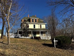 | John Conkin and Clara Layton Harlin House | building | 2003 | 03001065 |
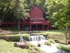 | Hodgson-Aid Mill | building | 2002 | 02000015 |
Every wildfire the federal occurrence database records inside this county: 556 of them, burning about 15,598 acres. 17 started naturally and 170 were recorded as arson. Each settlement page carries the fires within five miles of it.
| Reported cause | Fires |
|---|---|
| Debris and open burning | 224 |
| Arson/incendiarism | 170 |
| Missing data/not specified/undetermined | 97 |
| Equipment and vehicle use | 27 |
| Natural | 17 |
| Smoking | 9 |
| Recreation and ceremony | 5 |
| Misuse of fire by a minor | 4 |
| Power generation/transmission/distribution | 2 |
| Fireworks | 1 |
The five largest, by the area the report gives. One of them was set deliberately.
| Date | Cause | Size | Reported by | Name on the report |
|---|---|---|---|---|
| 28 July 2012 | Natural | 1,126 acres | Mark Twain National Forest | POTATO CAVE |
| 23 March 2011 | Missing data/not specified/undetermined | 740 acres | Missouri Department of Conservation | MAMMOTH |
| 21 March 1995 | Equipment and vehicle use | 721 acres | Missouri Department of Conservation | not named |
| 8 April 2016 | Natural | 600 acres | Missouri Department of Conservation | 135569-07718-04082016-1310 |
| 23 March 2011 | Debris and open burning | 455 acres | Arkansas Forestry Commission | CR-164 |
| 12 March 2011 | Missing data/not specified/undetermined | 433 acres | Mark Twain National Forest | BETHEL |
| 18 February 1994 | Debris and open burning | 432 acres | Missouri Department of Conservation | not named |
| 19 February 2011 | Arson/incendiarism | 410 acres | Mark Twain National Forest | WATERHOLE |
Every settlement page carries the fires within five miles of it - see the settlement index below.
The NOAA Storm Events Database holds 713 reports for this county, causing 5 deaths, 11 injuries and about $50,204,660 in recorded property damage. Each settlement page carries the reports that name it.
| Kind of event | Reports |
|---|---|
| Thunderstorm Wind | 201 |
| Hail | 188 |
| Flood | 145 |
| Flash Flood | 126 |
| Tornado | 36 |
| Heavy Rain | 13 |
| Lightning | 3 |
| Funnel Cloud | 1 |
The most serious of them, by death, then injury, then recorded damage. The accounts are quoted exactly as the forecast office filed them.
| When | Event | Place named | Harm | What the report says |
|---|---|---|---|---|
| March 2025 | Tornado (EF3) | Dawt | 3 killed, 4 hurt, $2,000,000 | This is the continued path of the tornado that came out of Baxter County Arkansas. An EF-3 tornado with peak winds of 145 mph moved through Bakersfield, Missouri resulting in three fatalities and four injuries. In Ozark County, the tornado destroyed several homes and damaged dozens of other homes. Multiple cars were rolled 50 to 100 yards. Numerous trees were also uprooted including entire groves of trees destroyed. This tornado then moved northeast into Howell County. |
| September 2024 | Thunderstorm Wind | Elijah | 1 killed, $10,000 | A thunderstorm with a wet microburst created very localized winds estimated at 40 to 50 mph. These winds overturned a camper at a campground in eastern Ozark County. Adjacent campers were not affected by these winds. |
| April 2011 | Flash Flood | Mammoth | 1 killed | A vehicle driven by a 54 year old male was swept off County Road 528 along Lick Creek. |
| December 1982 | Tornado (F2) | not stated | 2 hurt, $250,000 | no account filed |
| April 1979 | Tornado | not stated | 2 hurt, $250,000 | no account filed |
| March 1977 | Tornado (F1) | not stated | 2 hurt, $25,000 | no account filed |
| May 1961 | Tornado (F3) | not stated | 1 hurt, $250,000 | no account filed |
| April 1982 | Tornado (F4) | not stated | $25,000,000 | no account filed |
| November 2024 | Flash Flood | Rockbridge | $6,000,000 | Highway-95 was closed due to flooding. Additional county property damages were reported throughout the entire county, primarily to dirt roads and bridges. Damage cost estimates are a reflection of the county as a whole. |
| April 2011 | Flash Flood | Gainesville | $4,000,000 | Widespread flooding of low water crossings and rural roads throughout the county was reported by emergency management.||The total cost estimate for flooding damages for Ozark County for this entire episode has been included. This includes roads, bridges, and structures which were affected. |
| April 2017 | Flash Flood | Lawndale | $3,000,000 | Numerous homes and business sustained severe flood damage across Ozark County. Numerous roads and bridges were severely damaged or washed away across the county. Dawt Mill suffered extreme flood damage as well as other river outfitters. This report will contain the total dollar estimate for flood damage to infrastructure, businesses, and homes across Ozark County. |
| May 2009 | Thunderstorm Wind | Longrun | $3,000,000 | Sixty to 80 mph wind gusts impacted much of Ozark County. The northern half of the county experienced the greatest damage, mainly in the form of uprooted trees. A few outbuildings were also damaged. The Ozark County Times, a newspaper in Gainesville, stated that thousands of trees were damaged. Power poles were also impacted, knocking out power to 2,300 residences and businesses. There were also a few outbuildings in Theodosia and Isabella that were completely destroyed. |
| March 2008 | Flash Flood | Longrun | $1,000,000 | Five to seven inches of rain fell over Ozark County. All areas that typically experience flooding during periods of excessive rain were flooded. |
| April 2010 | Tornado (EF1) | Lawndale | $875,000 | An EF-1 tornado with maximum winds estimated at 110 mph damaged 30 homes, some severely, along with numerous barns and other outbuildings. Hundreds of oaks trees were damaged including many that were uprooted or snapped. |
| July 2015 | Flash Flood | Rockbridge | $500,000 | State Highway 95 was closed due to flooding. This storm report will contain the overall flood damage estimates across the entire Ozark County for this storm event. There were several episodes and heavy rainfall events which led to a compound affect to the flooding damage. Numerous roads, bridges, and low water crossings were heavily damaged. |
| December 2015 | Flash Flood | Howards Ridge | $500,000 | Route J north of Highway T was closed near Lick Creek. Nearly all low water crossings were flood across the county. Numerous rural and county roads sustained significant flood damage. There were several buildings that suffered flood damage. This storm report will contain the damage estimates for the entire county for this event. |
| August 1993 | Thunderstorm Wind | Pontiac | $500,000 | A local newspaper reported substantial wind damage to six docks at Pontiac Cove Marina. The high wind also blew 3,000 square feet of tin roofing over two other docks and damaged four boats. |
| May 1961 | Tornado (F3) | not stated | $250,000 | no account filed |
| March 1961 | Tornado (F2) | not stated | $250,000 | no account filed |
| March 1961 | Tornado (F1) | not stated | $250,000 | no account filed |
| July 2016 | Lightning | Trail | $200,000 | Dora, Eastern Douglas County and Caney Mountain volunteer fire departments worked together July 26 to extinguish a house fire on Tetrick Lane. The firefighters were able to extinguish the flames before the house burned to the ground, but the home was a complete loss. The report was made to the Ozark County Sheriffs Department at 2:55 p.m. The fire was a result of a lightning strike that entered the structure through telephone lines, according to the Dora VFD. |
| July 2012 | Thunderstorm Wind | Mammoth | $200,000 | A downburst knocked down numerous trees and power lines along Highway 5 south of Gainesville. The downed power lines caused a fire which destroyed two homes. Time was estimated. |
| May 2009 | Tornado (EF1) | Toledo | $200,000 | A National Weather Service storm survey revealed that an EF-1 tornado impacted a rural section of northwest Ozark County. The tornado destroyed seven outbuildings and damaged three houses. Tree damage was intense, particularly near the intersection of County Road 950 and County Road 955. |
| October 2019 | Tornado (EF1) | Trail | $100,000 | A National Weather Service survey confirmed an EF-1 tornado started near Bryant Creek to the southwest of Dora in northern Ozark County before crossing into southeastern Douglas County finally lifting northeast of Dora. The tornado heavily damaged numerous outbuildings and trees along Highway CC southwest of Dora. Two mobile homes were also damaged along Highway CC, with one of the mobile homes losing a roof and being pulled off its foundation. The tornado then crossed into Douglas County just north of County Road 382 just east of Highway 181 and continued for another 7 miles. The tornado was on the ground for a total of 12 minutes the first 6 of which were in Ozark County. The total path length was 13.05 miles with a maximum wind of 105 mph, and a maximum path width of 1/4 mile. |
| August 2013 | Flash Flood | Gainesville Arpt | $100,000 | This storm report will include the total estimated damages due to the flooding across the county. A couple low water crossings were flooded and damaged. Highway 181 was flooded and impassable. |
| April 2010 | Tornado (EF1) | Hardenville | $80,000 | An EF-1 tornado produced 90 to 100 mph winds uprotting numerous trees, damaging several outbuildings, a horse trailer, and downing power lines and poles. |
| May 2015 | Tornado (EF1) | Lutie | $75,000 | A NWS storm survey team found that an EF-1 tornado touched down about two miles west of Theodosia. The tornado tracked north-northeast and lifted about two and a half miles east of Longrun. The tornado caused minor damage to a mobile home and three barns were destroyed. Several hundred trees were uprooted or snapped along the path. The maximum estimated winds were up to 95 mph. The path length was about 5 miles long and the path width was about 200 yards wide. |
| January 2000 | Lightning | Gainesville | $70,000 | no account filed |
| August 2023 | Thunderstorm Wind | Isabella | $60,000 | Several power lines and poles were downed by high winds along Highway 5 from the Arkansas State line and on Highway W. |
| April 2025 | Flash Flood | Bakersfield | $50,000 | Fast flowing high water caused road surface damage to a portion of Highway 142 near Bakersfield. |
| June 2015 | Flash Flood | Rockbridge | $50,000 | Highway 95 at Bryant Creek was closed due to flood water. This storm report will contain the overall storm damage estimates across Ozark County for this storm event. Numerous roads, bridges, and low water crossings were heavily damaged. |
| August 2013 | Thunderstorm Wind | Thornfield | $50,000 | Numerous trees and power poles were blown down along with numerous power outages. |
| January 2005 | Tornado (F0) | Tecumseh | $50,000 | A brief tornado touched down near the community of Tecumseh. Several large trees were snapped along Highway 160 near Cloud Nine Resort. |
| March 1993 | Tornado (F0) | Gainesville | $50,000 | A tornado touched down briefly off of Highway 181 damaging an outbuilding and several homes. Pieces of the outbuilding were found a half mile away and 2-by-4 boards were driven through the roof of an old home. Boards were also found stuck in the ground like arrows along with roof shingles torn off. |
| August 2002 | Tornado (F1) | Wasola | $50,000 | no account filed |
| August 2000 | Thunderstorm Wind | Gainesville | $50,000 | no account filed |
| March 1993 | Hail | Theodosia | $50,000 | no account filed |
| April 2025 | Thunderstorm Wind | Pondfork | $40,000 | A barn suffered significant damage. |
| August 2023 | Thunderstorm Wind | Pontiac | $40,000 | Multiple trees were uprooted or snapped along Highway 5 to the Arkansas State line. Several power lines were down as well. One tree fell on a home causing minor shingle roof damage. |
| June 2021 | Thunderstorm Wind | Toledo | $40,000 | Numerous large limbs were reported down on power lines causing widespread power outages. |
| October 2019 | Thunderstorm Wind | Sycamore | $28,000 | A barn and several outbuildings suffered minor to moderate damage. |
| August 2022 | Thunderstorm Wind | Dora | $25,000 | The Dora area had five power lines and two power poles broken along with trees on power lines. |
| April 2019 | Tornado (EF1) | Ocie | $25,000 | This is the continuation of the tornado that touched down and tracked from four miles northeast of Protem, Missouri and tracked to five miles northwest of Theodosia in Ozark County, Missouri. A National Weather Service Storm survey confirmed an EF-1 tornado touched down four miles northeast of Protem, Missouri and tracked to five miles northwest of Theodosia in Ozark County Missouri. The tornado was on the ground for approximately eight minutes along its 5.4 mile total track maximum wind speeds estimated at 100 mph. This tornado was videotaped at a Theodosia storage business, and was also observed by a local pharmacist. Along with trees snapped and uprooted as the tornado moved to the northeast across western Ozark County, two outbuildings were damaged as it crossed Highway 160. The tornado lifted northeast of County Road 902. |
| April 2016 | Hail | Gainesville | $25,000 | A picture from social media showed hail size up to 2 inches. Several cars sustained dents and damage in the area. |
| April 2011 | Hail | Zanoni | $25,000 | Windows on a car were broken from softball size hail. |
| November 2001 | Thunderstorm Wind | Pontiac | $25,000 | no account filed |
| February 1999 | Thunderstorm Wind | Isabella | $25,000 | no account filed |
| October 1984 | Tornado (F1) | not stated | $25,000 | no account filed |
| May 1973 | Tornado (F1) | not stated | $25,000 | no account filed |
| December 1967 | Tornado (F1) | not stated | $25,000 | no account filed |
| April 2023 | Thunderstorm Wind | Toccoa | $20,000 | Two barns suffered minor to moderate damage from high winds. |
| August 2023 | Thunderstorm Wind | Lutie | $20,000 | A few trees were blown over and a home suffered minor to moderate roof damage. |
| June 2021 | Thunderstorm Wind | Lutie | $20,000 | Several trees and power lines were reported down in town along Highway 160. |
| October 2019 | Thunderstorm Wind | Lutie | $20,000 | A large tree fell on a home causing minor to moderate damage. |
| July 2020 | Thunderstorm Wind | Tecumseh | $15,000 | The electric cooperative reported limbs and power lines down near Tecumseh. |
| October 2019 | Thunderstorm Wind | Sycamore | $15,000 | A barn suffered moderate damage. |
| July 2018 | Thunderstorm Wind | Toledo | $15,000 | Roof and vehicle damage was reported due to multiple large tree limbs downed by strong winds. The time was estimated by radar. |
| July 2024 | Thunderstorm Wind | Dora | $12,000 | Utility company reported that trees were blown into power lines, breaking three poles. Lightning caused a few breakers to open, causing power outages for over 700 homes. |
| June 2023 | Thunderstorm Wind | Dora | $10,000 | A large tree was blown down on a power line. |
| April 2017 | Flash Flood | Gainesville | $10,000 | There was a vehicle in the flood water near Lick Creek at Highway 160 and Highway 5 in Gainesville. |
The Survey's mineral resources record lists 43 workings inside this county. 3 still produce and 40 are closed or unrecorded. Each settlement page carries the workings within five miles of it.
| Commodity | Workings |
|---|---|
| Iron | 30 |
| Zinc | 3 |
| Sand and Gravel, Construction | 3 |
| Lead, Zinc | 3 |
| Stone, Crushed/Broken | 2 |
| Aluminum | 1 |
| Clay | 1 |
The least common of them first, because a county's hundredth gravel pit says nothing its first ten did not.
| Where | Site | Commodity | Status | Recorded |
|---|---|---|---|---|
| Nourse Farm | Aluminum | Past Producer | ||
| Unknown - Clay | Clay | Past Producer | ||
| D + D Lime Quarry | Stone, Crushed/Broken | Past Producer | ||
| Gainesville Quarry & Mill | Stone, Crushed/Broken | Producer | ||
| Alice Mine | Zinc | Past Producer | 1888, 1890 | |
| Alice Mine | Lead, Zinc | Past Producer | ||
| Golman Turner Pit | Zinc | Past Producer | ||
| Holt Shafts | Lead, Zinc | Past Producer | ||
| Portable S&G Plant | Sand and Gravel, Construction | Producer | ||
| Sharp Mine | Zinc | Past Producer | 1893 | |
| Unknown - Lead-Zinc | Lead, Zinc | Past Producer | ||
| Unknown - S+G | Sand and Gravel, Construction | Past Producer | ||
| Wallace Cement Pit & Plant | Sand and Gravel, Construction | Producer | ||
| Arnett Land | Iron | Past Producer | ||
| B H + B Mine | Iron | Past Producer | ||
| Bradley Land | Iron | Prospect | ||
| Buttrom Land Number Two | Iron | Prospect | ||
| Charles Rippee Iron Mine | Iron | Occurrence | Surface | |
| Collins Land | Iron | Past Producer | ||
| Everett Mahan Prospect | Iron | Past Producer | ||
| Garrett Bank | Iron | Past Producer | ||
| Glazier Land | Iron | Past Producer | ||
| J C Bond Prospect | Iron | Past Producer | ||
| John Skiles | Iron | Prospect | 1953 | |
| L M Strong Pit | Iron | Past Producer | ||
| Newton Mining Co Land | Iron | Prospect | ||
| Patillo Brothers | Iron | Prospect | 1953 | |
| Pratt Land | Iron | Prospect | ||
| Price Land | Iron | Past Producer | ||
| Ralph Jacobs Prospect | Iron | Past Producer | ||
| South Missouri Land Co Number One | Iron | Past Producer | ||
| South Missouri Land Co Number Two | Iron | Past Producer | ||
| Steel Bank | Iron | Past Producer | ||
| Summers Mine | Iron | Past Producer | ||
| T A Manis Prospect | Iron | Past Producer | ||
| Unknown - Iron | Iron | Past Producer | ||
| Unknown - Iron | Iron | Past Producer | ||
| Unknown - Iron | Iron | Past Producer | ||
| Unknown - Iron | Iron | Past Producer | ||
| Unknown - Iron | Iron | Past Producer | ||
| Unknown - Iron | Iron | Past Producer | ||
| Unknown - Iron | Iron | Past Producer | ||
| Unknown - Iron | Iron | Past Producer |
Named settlements recorded in the Geographic Names Information System, each with the topographic sheets covering it. Villages, hamlets and abandoned places alike. Each is shown with the nearest named watercourse or landform and the survey quadrangle it falls on.
Barren Fork township · 65773 · Near Smith Hollow · Wasola quadrangle
14 sheets, 1936 to 2004
Bayou I township · 65609 · Near Plumb Hollow · Bakersfield quadrangle
13 sheets, 1944 to 1985
Bayou II township · 65626 · Near Manes Hollow · Bakersfield quadrangle
13 sheets, 1944 to 1985
Thornfield township · 65755 · Near Buzzard Roost Hollow · Smallett quadrangle
14 sheets, 1936 to 2004
West Bridges township · 65655 · On Becky Cobb Creek · Gainesville quadrangle
14 sheets, 1934 to 1985
Thornfield township · 65762 · On Turkey Creek · Thornfield quadrangle
13 sheets, 1936 to 2004
Bridges township · 65655 · Near Tecumseh Ridge · Udall quadrangle
13 sheets, 1934 to 1985
Spring Creek township · 65790 · Near Pond Hollow · Cureall NW quadrangle
14 sheets, 1944 to 2004
Lick Creek township · 65655 · Near Moore Hollow · Udall quadrangle
13 sheets, 1934 to 1985
West Bridges township · 65729 · Near Pocket Hollow · Isabella quadrangle
14 sheets, 1936 to 2004
Longrun township · 65761 · Near Washington Bald · Thornfield quadrangle
13 sheets, 1936 to 2004
Bridges township · 65655 · On Possum Walk Creek · Gainesville quadrangle
14 sheets, 1934 to 1985
Nottinghill township · 65762 · Near Bennett Hollow · Willhoit quadrangle
13 sheets, 1936 to 2004
Spring Creek township · 65790 · Near Dividing Ridge · Cureall NW quadrangle
14 sheets, 1944 to 2004
Thornfield township · 65762 · Near Caney Hollow · Thornfield quadrangle
13 sheets, 1936 to 2004
Pontiac township · 65729 · On Bratten Spring Creek · Isabella quadrangle
14 sheets, 1936 to 2004
Jackson township · 65741 · Near Shiloh Hollow · Rockbridge quadrangle
13 sheets, 1937 to 1985
Barren Fork township · 65773 · Near Cooper Hollow · Willhoit quadrangle
13 sheets, 1936 to 2004
Noble township · 65773 · Near Mount Lebanon Hollow · Willhoit quadrangle
13 sheets, 1936 to 2004
Pine Creek township · 65760 · Near Lottie Hollow · Sycamore quadrangle
12 sheets, 1934 to 1985
Big Creek township · 65761 · Near Ledbetter Hollow · Theodosia quadrangle
14 sheets, 1936 to 2004
Jasper township · 65761 · Near Guber Hollow · Theodosia quadrangle
14 sheets, 1936 to 2004
No longer a settlement
Thornfield township · 65762 · On Little Creek · Thornfield quadrangle
13 sheets, 1936 to 2004
Thornfield township · 65608 · Near Maloney Hollow · Smallett quadrangle
14 sheets, 1936 to 2004
Richland township · 65638 · Near Stephens Hollow · Gentryville quadrangle
13 sheets, 1937 to 1985
Barren Fork township · 65773 · On Ludecker Creek · Willhoit quadrangle
13 sheets, 1936 to 2004
The vanished settlements of Ozark County: the places named above that are no longer on the map.