 Block
From the record
3 National Register listings published here.
Sources: the National Register database, National Park Service
56 topographic sheets cover 43 settlements here, and 3 properties are on the National Register of Historic Places.
3 National Register listings published here.
Sources: the National Register database, National Park Service
Every property in this county listed on the National Register of Historic Places, with the year it was listed and the federal nomination document.
| Photograph | Property | Type | Listed | Reference |
|---|---|---|---|---|
| Levi Morrill Post | building | 1979 | 79001397 | |
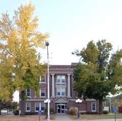 | Stone County Courthouse | building | 1980 | 80002396 |
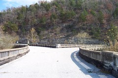 | Y Bridge | structure | 1991 | 91000591 |
Every wildfire the federal occurrence database records inside this county: 281 of them, burning about 5,388 acres. None started naturally and 44 were recorded as arson. Each settlement page carries the fires within five miles of it.
| Reported cause | Fires |
|---|---|
| Debris and open burning | 164 |
| Missing data/not specified/undetermined | 48 |
| Arson/incendiarism | 44 |
| Equipment and vehicle use | 9 |
| Recreation and ceremony | 7 |
| Smoking | 5 |
| Misuse of fire by a minor | 4 |
The five largest, by the area the report gives. Three of them were set deliberately.
| Date | Cause | Size | Reported by | Name on the report |
|---|---|---|---|---|
| 29 July 2012 | Missing data/not specified/undetermined | 444 acres | Missouri Department of Conservation | MARIONVILLE |
| 18 February 2004 | Missing data/not specified/undetermined | 322 acres | Missouri Department of Conservation | AVERY RIDGE |
| 1 April 2001 | Arson/incendiarism | 250 acres | Missouri Department of Conservation | not named |
| 29 March 2014 | Missing data/not specified/undetermined | 220 acres | Missouri Department of Conservation | not named |
| 27 March 1998 | Debris and open burning | 200 acres | Missouri Department of Conservation | not named |
| 4 December 2005 | Arson/incendiarism | 191 acres | Mark Twain National Forest | RAIL HOLLOW |
| 5 May 1997 | Debris and open burning | 160 acres | Missouri Department of Conservation | not named |
| 19 February 1995 | Arson/incendiarism | 150 acres | Missouri Department of Conservation | not named |
Every settlement page carries the fires within five miles of it - see the settlement index below.
The NOAA Storm Events Database holds 680 reports for this county, causing 18 deaths, 25 injuries and about $38,762,200 in recorded property damage. Each settlement page carries the reports that name it.
| Kind of event | Reports |
|---|---|
| Hail | 274 |
| Thunderstorm Wind | 227 |
| Flash Flood | 97 |
| Tornado | 32 |
| Flood | 25 |
| Heavy Rain | 15 |
| Lightning | 7 |
| Wildfire | 2 |
| Funnel Cloud | 1 |
The most serious of them, by death, then injury, then recorded damage. The accounts are quoted exactly as the forecast office filed them.
| When | Event | Place named | Harm | What the report says |
|---|---|---|---|---|
| July 2018 | Thunderstorm Wind | Notch | 17 killed | A line of severe thunderstorms producing 50 to 70 mph winds caused wind damage across Stone County. On Table Rock Lake, winds of over 60 mph led to high waves. An amphibious tourist vehicle sank with seventeen fatalities and numerous injuries reported. |
| July 2023 | Thunderstorm Wind | Blue Eye | 1 killed, $40,000 | A large oak tree was up rooted and fell on a camper trailer at the Old 86 Campground at Table Rock Lake. A woman sleeping in the camper was killed. |
| February 2012 | Tornado (EF2) | Kimberling City | 10 hurt, $5,500,000 | An EF-2 tornado tracked from near Kimberling City near Joe Bald Road to 1.5 miles west of Branson where it crossed the county line into Taney County. Estimated maximum wind speeds were from 120 to 130 mph. Maximum path width was 400 yards. Path in Stone County was nearly eight miles and the overall length was approximately 22 miles. Damage was reported to 30 homes in Kimberling City, as well as the Joe Bald, Indian Point, Compton Ridge and Gobbler's Mountain areas. Significant damage occurred to the Kimberling Inn. At the Port of Kimberling Marina, four large boat docks were damage or destroyed and nearly 150 boats were damaged though only one was sunk. The tornado track continued into Taney County and struck Branson, Missouri. |
| March 1973 | Tornado (F2) | not stated | 4 hurt, $25,000 | no account filed |
| August 2023 | Thunderstorm Wind | Reeds Spg | 3 hurt, $150,000 | A large tree was blown onto a home falling through the roof into the living area. Several people were trapped and treated for minor injuries on site after being extracted. Significant damage to the home was reported. |
| August 1970 | Tornado (F1) | not stated | 3 hurt, $25,000 | no account filed |
| April 2000 | Wildfire | Countywide | 3 hurt, $20,000 | no account filed |
| July 2004 | Thunderstorm Wind | Countywide | 1 hurt, $100,000 | Stone County experienced significant damage countywide from A derecho that swept through much of southwestern Missouri during the early morning hours of July 4th. Numerous trees and power lines were downed, along with damaged homes and billboard signs. One individual was hospitalized after being struck by flying debris. |
| September 1968 | Tornado (F2) | not stated | 1 hurt, $25,000 | no account filed |
| March 2008 | Flash Flood | Crane | $7,000,000 | Record flooding occurred along the James River over Stone County. 60 homes were destroyed by flooding while approximately 30 of these homes were washed away into the James River. These homes were in the communities of Hooten Town, Bakers Hole, and Galena. The flooding was caused from rainfall amounts up to eight inches near the head waters of the James and Finley rivers. Nearly all low areas that typically experience flooding during excessive rainfall were flooded. |
| April 2011 | Flash Flood | Galena | $4,000,000 | Route AA was closed due to flooding.||The total cost estimate for flooding damages for Stone County for this entire episode has been included. This includes roads, bridges, and structures which were affected. |
| April 2017 | Flash Flood | Galena | $2,000,000 | Numerous homes and business sustained flood damage across Stone County. Numerous roads and bridges were severely damaged or washed away across the county. Galena was especially hit hard with flooding along the James River. This report will contain the total dollar estimate for flood damage to infrastructure, businesses, and homes across Dent County. |
| July 2015 | Flash Flood | Reeds Spg | $2,000,000 | Significant flooding occurred at Reeds Spring with major street flooding. State Highway 248 and Highway 265 were closed. This storm report will contain the overall flood damage estimates across the entire Stone County for this storm event. There were several episodes and heavy rainfall events which led to a compound affect to the flooding damage. Numerous roads, bridges, and low water crossings were heavily damaged. Several businesses in Reeds Spring suffered flood damage. |
| December 2010 | Tornado (EF1) | Lampe | $2,000,000 | The NWS storm survey revealed that a strong EF-1 tornado impacted the eastern shore line of the Highway DD peninsula. This tornado crossed six different coves, damaging or destroying 11 boat docks. There were approximately 25 boats that were either damaged or destroyed. Approximately 60 homes experienced minor to moderate roof damage. One well built brick home had lost its entire roof. This home was located in the Trails End community. The peak wind speeds were estimated at 110 miles per hour. |
| January 2008 | Tornado (EF1) | Elsey | $2,000,000 | This tornado is an extension of the Barry County tornado. A National Weather Service storm survey revealed that an EF-1 tornado tracked across rural sections of Stone County. Poultry barns, sheds, and outbuildings in the vicinity of Boomerrang Road and Highway 248 were heavily damaged or destroyed. Several poultry barns were also destroyed along Horsecreek Road. |
| April 2001 | Thunderstorm Wind | Kimberling City | $2,000,000 | no account filed |
| December 2015 | Flood | Galena | $1,500,000 | There were at least 20 homes flooded from the James River at Galena. There were at least six homes flooded near Hootentown from the James River. Several businesses suffered flood damage along the James River and across the county. Numerous low water crossings and roads sustained damage from flood water. Several boat docks and campground areas around Table Rock Lake suffered flood damage as well. This storm report will contain the damage estimates for the entire county for this event. |
| May 2011 | Tornado (EF2) | Elsey | $1,000,000 | Tornado damage was first indicated on Cave Springs Road where trees were snapped and twisted. EF-0 damage was indicated at this point. The tornado then traveled east, partially damaging a mobile home and destroying another mobile home on Highway AA, near the intersection with Camp Clark Hill Road. Damage at this location was rated EF-1. Several turkey barns were then damaged along Horse Creek Road with EF-2 damaged noted. EF-0 damage to trees and a roof were noted along Johnson Rowe Road. EF-1 damage occurred along Bass Hollow Road where damage to a house and outbuildings occurred. This tornado continued into Taney County with maximum wind speeds estimated up to 120 mph at its peak and a maximum path width of 200 yards. |
| April 2001 | Tornado (F1) | Kimberling City | $1,000,000 | no account filed |
| July 2024 | Thunderstorm Wind | Cape Fair | $750,000 | A 280 foot free standing cell phone tower collapsed. The strongest winds near 100 mph remained at the tower height, which was built at a 1308 foot elevation. |
| December 2010 | Tornado (EF0) | Notch | $750,000 | An EF-0 tornado touched down along the southern point of the Indian Point peninsula. The tornado impacted a neighborhood with frame homes prior to damaging the eastern shore ling of the peninsula. Four coves were affected by this tornado damaging approximately six boat docks and four boats . These boat docks had mainly open slips. There was damaged to one boat dock at Rock Lane Resort. The peak wind speeds were estimated at 70 miles per hour. |
| April 1999 | Thunderstorm Wind | Kimberling City | $550,000 | no account filed |
| December 2021 | Tornado (EF1) | Reeds Spg | $500,000 | A National Weather Service storm survey determined that a short lived EF-1 tornado impacted areas near Branson West. The EF-1 tornado had estimated maximum winds of 90 mph along it nearly three quarters of a mile path with a maximum damage path width of 75 yards. Along the tornadoes path damage occurred to roofs and siding of 20 homes. Additionally, multiple trees and power lines were downed. |
| July 2015 | Flash Flood | Reeds Spg | $500,000 | Several streets were flooded and closed in downtown Reeds Spring. Water was getting into some homes and businesses. This storm report will contain the overall flood damage estimates across Stone County for this storm event. Numerous roads, bridges, and low water crossings were heavily damaged. |
| May 2009 | Thunderstorm Wind | Crane | $500,000 | Sixty to 80 mph winds impacted a widespread area of Stone County. These severe thunderstorm wind gusts downed thousands of trees, particularly in the northern half of the county. The only known structural damage from these winds occurred at the Branson West Wal-Mart. A two foot hole was ripped off the roof causing heavy rain to flow inside the store, damaging merchandise. Several roads were blocked from downed trees. |
| June 2008 | Flash Flood | Crane | $500,000 | Fourty water rescues resulted from major flash flooding across Stone County. 30 people were rescued from an RV campground near Galena, while nine others were rescued from a mobile home park in Reeds Spring. Numerous county roads were washed out with heavy damage. A shelter was opened for flood victims. Rainfall amounts ranged from four to seven inches. |
| January 2008 | Flash Flood | Crane | $500,000 | Training thunderstorms over the northern one third of Stone County caused significant flash flooding. Several roads and low water crossings were washed away. Rainfall measurements indicated that 2.5 inches to 4.5 inches of rain occurred in northern Stone County. |
| September 1996 | Lightning | Viola | $500,000 | no account filed |
| March 2015 | Lightning | Notch | $300,000 | A lightning strike hit a house in the Stonebridge Resort community and caused a house fire. The fire completely destroyed the house and contents inside. There were three cars in the garage that were a total loss as well. Time was estimated. |
| December 1982 | Tornado (F1) | not stated | $250,000 | no account filed |
| March 1961 | Tornado (F2) | not stated | $250,000 | no account filed |
| July 2024 | Thunderstorm Wind | Cape Fair | $200,000 | Thunderstorm winds ranging from 70 to 80 mph caused a portion of the marina to break away from the mooring, with the dock sustaining most of the damage. 20 boats were reported damaged. Tree branches were also broken, with a few trees uprooted and snapped. |
| May 2019 | Lightning | Reeds Spg | $150,000 | Lightning struck a local restaurant. Significant damage occurred to the structure with most of the building suffering fire and smoke damage. |
| May 2020 | Hail | Kimberling City | $125,000 | Golf ball sized hail was reported near the Kimberling City Bridge. Several vehicles and businesses had minor hail damage. |
| July 2016 | Thunderstorm Wind | Reeds Spg | $100,000 | Numerous trees and large tree limbs were blown down in the Burlington Subdivision. Several roofs were damaged as well as siding and fencing. Time was estimated by radar. |
| June 2014 | Thunderstorm Wind | Lampe | $100,000 | Two boat docks were heavily damaged and several others broke loose from their moorings. Several house boats were damaged. |
| April 2008 | Flash Flood | Crane | $100,000 | Three to five inches of rain fell over Stone County. Any areas that typically flood during periods of excessive rainfall were flooded. Table Rock Lake rose to an all time high of 933.25 feet above sea level. This lake level flooded a few homes. |
| July 2025 | Thunderstorm Wind | Viola | $75,000 | A small boat dock was flipped over and multiple trees were snapped by high winds. |
| May 2020 | Hail | Hurley | $75,000 | Golf ball hail was reported near the town of Hurley. Minor damage occurred to homes and vehicles in town. |
| May 2023 | Thunderstorm Wind | Hurley | $60,000 | Multiple power poles and lines were downed by high winds causing power outages. |
| May 2010 | Lightning | Viola | $60,000 | Lightning struck and burned a Jeep in a parking lot. The heat from the burning Jeep scorched two other cars next to the Jeep. |
| June 2025 | Thunderstorm Wind | Kimberling City | $50,000 | Sixty to seventy mph winds downed trees and power lines. Four boats were capsized on Table Rock Lake. |
| May 2022 | Hail | Silver Dollar City | $50,000 | Golf ball sized hail was reported in Kimberling City. Minor damage to vehicles occurred. |
| December 2018 | Thunderstorm Wind | Kimberling City | $50,000 | Severe thunderstorm wind gusts severely damaged a home just northeast of the confluence of the White and James rivers on Table Rock Lake. Wind speeds were estimated at 80 mph, which ripped a large chunk of a roof off of the home. |
| June 2015 | Flood | Jamesville | $50,000 | Route U along the James River was flooded and closed. This storm report will contain the overall storm damage estimates across the entire Stone County for this storm event. Several roads, bridges, and low water crossings were heavily damaged. |
| June 2014 | Hail | Lampe | $50,000 | Hail damaged numerous metal roofs and cars along with breaking windows. |
| August 2013 | Flash Flood | Blue Eye | $50,000 | Several residents in the Blue Eye area off Highway 13 and Highway 86 along Brush Creek are being rescued due to high water as water began to enter homes. |
| April 2011 | Thunderstorm Wind | Kimberling City | $50,000 | Several docks were damaged by straight line winds. Some boats were reported as being damaged with a few smaller boats flipped over. |
| December 2010 | Tornado (EF0) | Blue Eye | $50,000 | The Stone County Office of Emergency Management surveyed damage from a tornado approximately three miles south-southeast of Lampe. There was minor damage to one frame home and one mobile home. There was damage to two large farm gas tanks, a stock trailer, and an outbuilding. The peak wind speeds were estimated at 65 miles per hour. |
| February 1997 | Thunderstorm Wind | Reeds Spg | $50,000 | no account filed |
| June 1995 | Hail | Hornersville | $50,000 | no account filed |
| March 1993 | Hail | Kimberling City | $50,000 | no account filed |
| April 2019 | Tornado (EF1) | Elsey | $40,000 | A National Weather Service survey confirmed an EF-1 tornado that tracked a total of 23 miles from one mile northeast of Galena to six miles southwest of Chadwick, Missouri. The tornado was on the ground for approximately 25 minutes along its 23 mile total track with maximum wind speeds estimated at 100 mph. The tornado tracked for eleven miles across central and east central Stone County before continuing into southwestern Christian County. As the tornado tracked across Stone County, it produced an intermittent damage path, which was detected as a long lived TDS on radar. Numerous trees were damaged near the touchdown point and the roof of a large machine shed was removed. As the tornado continued east it rolled a pickup truck approximately 40 yards into a house. Significant tree damage continued across east central Stone County before the tornado continued its track into southwestern Christian County. |
| November 2024 | Tornado (EF0) | Elsey | $35,000 | A NWS storm survey confirmed that a brief EF-0 tornado with peak winds of 77 mph, a path length of 1.40 miles, and a width of 50 yards occurred 1 mile west-northwest of Elsey in Stone County. This tornado uplifted roofs to an outbuilding and outbuilding sheds, caused roof damage to both a church and a home, and snapped several large tree branches. |
| August 2019 | Thunderstorm Wind | Reeds Spg | $30,000 | Numerous large trees were downed and a few businesses had minor damage. |
| July 2024 | Hail | Cape Fair | $25,000 | Numerous reports of baseball size to three inch size hail in Cape Fair. |
| April 2021 | Thunderstorm Wind | Notch | $25,000 | Multiple trees and street lights were blown over on Indian Point. |
| June 2020 | Thunderstorm Wind | Lampe | $25,000 | Several power lines and poles were reported down causing multiple power outages. |
| August 2019 | Thunderstorm Wind | Reeds Spg | $25,000 | A National Weather Service storm survey found evidence of 80 to 85 mph winds causing severe damage to a large building at a business, with the damage facing to the south. Several large trees were also uprooted and blown down to the south in the area off of Highway 248/160 east of Reeds Spring. |
| July 2018 | Thunderstorm Wind | Notch | $25,000 | Several reports of power lines, power poles, trees, and tree limbs down were received in the area from Branson West to Kimberling City. Power was reported out in portions of Branson West and Kimberling City. |
The Survey's mineral resources record lists 19 workings inside this county. 1 still produces and 18 are closed or unrecorded. Each settlement page carries the workings within five miles of it.
| Commodity | Workings |
|---|---|
| Stone, Crushed/Broken | 8 |
| Lead, Zinc | 4 |
| Iron | 2 |
| Lead | 2 |
| Gold | 1 |
| Zinc, Lead | 1 |
| Sand and Gravel, Construction | 1 |
The least common of them first, because a county's hundredth gravel pit says nothing its first ten did not.
| Where | Site | Commodity | Status | Recorded |
|---|---|---|---|---|
| Unknown - Gold | Gold | Prospect | ||
| Unknown - Lead-Zinc | Zinc, Lead | Past Producer | ||
| Unknown - S&G | Sand and Gravel, Construction | Past Producer | ||
| Spoonhow Mine | Lead | Past Producer | ||
| Unknown - Iron | Iron | Past Producer | ||
| Unknown - Iron | Iron | Past Producer | ||
| Unknown - Lead | Lead | Past Producer | ||
| Unknown - Lead Zinc | Lead, Zinc | Past Producer | ||
| Unknown - Lead-Zinc | Lead, Zinc | Past Producer | ||
| Unknown - Lead-Zinc | Lead, Zinc | Past Producer | ||
| Wild Cat Mine | Lead, Zinc | Past Producer | ||
| Mason Quarry | Stone, Crushed/Broken | Past Producer | ||
| Reed Springs Quarry & Mill | Stone, Crushed/Broken | Producer | ||
| Table Rock Quarry # 2 | Stone, Crushed/Broken | Unknown | ||
| Unknown - Ls | Stone, Crushed/Broken | Past Producer | ||
| Unknown - Ls | Stone, Crushed/Broken | Past Producer | ||
| Unknown - Ls | Stone, Crushed/Broken | Past Producer | ||
| Unknown - Ls | Stone, Crushed/Broken | Past Producer | ||
| Unknown - Ls | Stone, Crushed/Broken | Past Producer |
Named settlements recorded in the Geographic Names Information System, each with the topographic sheets covering it. Villages, hamlets and abandoned places alike. Each is shown with the nearest named watercourse or landform and the survey quadrangle it falls on.
Ruth A township · 65656 · Galena quadrangle
12 sheets, 1907 to 1985
No longer a settlement
Ruth C township · 65737 · Near Indian Ridge · Garber quadrangle
15 sheets, 1907 to 1989
Flat Creek A township · 65624 · Near Emerson Hollow · Cape Fair quadrangle
15 sheets, 1927 to 1999
Ruth B Rural township · 65686 · Near Jannings Hollow · Lampe quadrangle
16 sheets, 1907 to 1999
No longer a settlement
Washington township · 65656 · Near Canady Hill Hollow · Galena quadrangle
12 sheets, 1907 to 1985
Ruth C Rural township · 65616 · On Little North Indian Creek · Garber quadrangle
15 sheets, 1907 to 1989
Cass township · 65631 · On Finley Creek · Highlandville quadrangle
12 sheets, 1907 to 1985
Ruth B City township · 65686 · By White Rock Bluff · Reeds Spring quadrangle
14 sheets, 1907 to 1999
Ruth B Rural township · 65686 · Near Little Joe Bald · Lampe quadrangle
16 sheets, 1907 to 1999
Ruth C township · 65737 · Near Sawmill Hollow · Garber quadrangle
15 sheets, 1907 to 1989
Washington township · 65656 · Near Powder Mill Hollow · Elsey quadrangle
12 sheets, 1942 to 1985
Alpine township · 65747 · Near Thompson Hollow · Cape Fair quadrangle
15 sheets, 1927 to 1999
Ruth B Rural township · 65737 · Near Crane Hollow · Reeds Spring quadrangle
14 sheets, 1907 to 1999
Ponce de Leon township · 65656 · On East Prong Goff Creek · Hurley quadrangle
12 sheets, 1907 to 1985
The vanished settlements of Stone County: the places named above that are no longer on the map.