 Block
From the record
6 National Register listings published here.
Sources: the National Register database, National Park Service
31 topographic sheets cover 26 settlements here, and 6 properties are on the National Register of Historic Places.
6 National Register listings published here.
Sources: the National Register database, National Park Service
Every property in this county listed on the National Register of Historic Places, with the year it was listed and the federal nomination document.
| Photograph | Property | Type | Listed | Reference |
|---|---|---|---|---|
| Camp Ground Church and Cemetary | building | 1985 | 85002483 | |
 | Green City Presbyterian Church | building | 2000 | 00000086 |
 | Green City Railroad Depot | building | 1999 | 98001610 |
| Henry Cemetery | site | 2005 | 05001472 | |
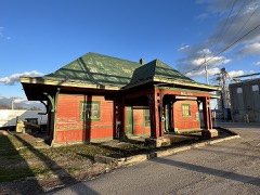 | Milan Railroad Depot | building | 1996 | 95001493 |
 | Quincy, Omaha and Kansas City Railroad Office Building | building | 1992 | 91001917 |
Every wildfire the federal occurrence database records inside this county: 12 of them, burning about 355 acres. None started naturally and 2 were recorded as arson. Each settlement page carries the fires within five miles of it.
| Reported cause | Fires |
|---|---|
| Debris and open burning | 8 |
| Missing data/not specified/undetermined | 2 |
| Arson/incendiarism | 2 |
The five largest, by the area the report gives. One of them was set deliberately.
| Date | Cause | Size | Reported by | Name on the report |
|---|---|---|---|---|
| 22 March 2019 | Missing data/not specified/undetermined | 229 acres | Missouri Department of Conservation | 179608-10547-03222019-1725 |
| 12 February 1992 | Debris and open burning | 40 acres | Missouri Department of Conservation | not named |
| 14 February 2002 | Debris and open burning | 25 acres | Missouri Department of Conservation | not named |
| 22 March 2019 | Missing data/not specified/undetermined | 18 acres | Missouri Department of Conservation | 179607-10547-03222019-1535 |
| 28 February 1992 | Debris and open burning | 15 acres | Missouri Department of Conservation | not named |
| 17 January 1992 | Debris and open burning | 10 acres | Missouri Department of Conservation | not named |
| 22 January 1992 | Arson/incendiarism | 5.0 acres | Missouri Department of Conservation | not named |
| 21 January 1992 | Debris and open burning | 4.0 acres | Missouri Department of Conservation | not named |
Every settlement page carries the fires within five miles of it - see the settlement index below.
The NOAA Storm Events Database holds 187 reports for this county, causing 1 death, no injuries and about $331,400 in recorded property damage. Each settlement page carries the reports that name it.
| Kind of event | Reports |
|---|---|
| Hail | 84 |
| Thunderstorm Wind | 75 |
| Flash Flood | 10 |
| Tornado | 9 |
| Funnel Cloud | 5 |
| Flood | 3 |
| Heavy Rain | 1 |
The most serious of them, by death, then injury, then recorded damage. The accounts are quoted exactly as the forecast office filed them.
| When | Event | Place named | Harm | What the report says |
|---|---|---|---|---|
| May 2009 | Tornado (EF1) | Milan | 1 killed, $25,000 | An EF1 tornado touched down at 1610 CST, about two miles north-northeast of Milan. The tornado proceeded east-northeast, and lifted about three and a half miles south-southeast of Boynton, at 1635 CST. The tornado destroyed a mobile home and killed a female occupant. Numerous trees were uprooted or damaged. |
| August 2004 | Flash Flood | Milan | $100,000 | Bridge washed out along State Route PP. Several area roads under water. Rainfall was from 6 to 9 inches in this area. |
| October 2004 | Thunderstorm Wind | Milan | $40,000 | Mobile home destroyed and grain bin knocked down. |
| May 2018 | Thunderstorm Wind | Newtown | $30,000 | A mobile home was overturned near Newtown. |
| June 1999 | Thunderstorm Wind | Humphreys | $30,000 | Barns were damaged by thunderstorm winds. |
| June 2010 | Thunderstorm Wind | Milan | $25,000 | A roof was reported to have blown off a house, south of Milan on Highway 5. One wall was partially blown down. |
| September 1970 | Tornado (F1) | not stated | $25,000 | no account filed |
| January 1967 | Tornado (F1) | not stated | $25,000 | no account filed |
| July 2010 | Tornado (EF0) | Harris | $10,000 | A brief EF0 tornado touchdown was observed in Harris at 20:42 CST. The tornado lifted at 20:43 CST. A residential roof was blown off. |
| August 2007 | Thunderstorm Wind | Green City | $5,000 | Thunderstorm wind gusts to 56 knots, caused six to nine power poles and lines to be downed on Highway 6. |
| August 1993 | Thunderstorm Wind | Milan | $5,000 | Several large trees were knocked down. |
| July 2008 | Hail | Pollock | $3,000 | Car and home windows were shattered by the large hail. |
| August 1964 | Tornado (F1) | not stated | $2,500 | no account filed |
| June 2018 | Thunderstorm Wind | Milan | $2,000 | Public reported numerous tree branches down across Milan as well as a swing set toppled over. |
| June 2008 | Thunderstorm Wind | Humphreys | $1,000 | Power pole was knocked down on Highway 6. |
| September 2008 | Flash Flood | Humphreys | $1,000 | A vehicle was swept off of Highway 139, due to fast flowing water. The driver was able to swim to safety. |
| October 2004 | Thunderstorm Wind | Newtown | $1,000 | Power lines down. |
| March 2011 | Thunderstorm Wind | Reger | $500 | An outbuilding was reported destroyed, with thunderstorm wind gusts estimated |to 60 mph. |
| July 2010 | Tornado (EF0) | Milan | $400 | A brief EF0 tornado touchdown was reported at 21:22 CST, 3 miles southwest of Milan. The tornado lifted at 21:23 CST. A roof was blown off a garage. |
| August 2025 | Thunderstorm Wind | Milan | - | Estimated wind gusts up to 65 mph about 3 miles northwest of Milan. |
| August 2025 | Thunderstorm Wind | Newtown | - | Large tree limbs downed in Newtown due to thunderstorm wind gusts. |
| August 2025 | Thunderstorm Wind | Harris | - | Tree limbs reported downed in Harris from thunderstorm winds. |
| June 2025 | Thunderstorm Wind | Cora | - | Several downed trees, some up to 4 feet in diameter, reported north to northeast of Browning. |
| June 2025 | Thunderstorm Wind | Green Castle | - | Downed wires near Lincoln Street in Greencastle. |
| April 2024 | Hail | Osgood | - | Quarter sized hail was reported just north of Osgood. |
| May 2024 | Hail | Milan | - | Golf ball sized hail was reported about 4 miles northwest of Milan. |
| May 2024 | Hail | Owasco | - | Golf ball sized hail was reported north of Owasco on Route Y. |
| May 2024 | Hail | Milan | - | Two inch sized hail was reported in Milan. |
| July 2023 | Thunderstorm Wind | Green City | - | Estimated wind gusts up to 60 mph in Green City. |
| June 2020 | Flood | Reger | - | State Route PP was closed near West Locust Creek west of Milan. |
| May 2019 | Thunderstorm Wind | Milan | - | Sullivan County Sheriff's office reported 60 mph winds. |
| May 2019 | Thunderstorm Wind | Milan | - | Amateur radio operator reported 58 mph winds. |
| September 2019 | Flood | Osgood | - | Route PP was closed in both directions due to high water. |
| August 2018 | Thunderstorm Wind | Browning | - | A tree was down along Highway 5 north of Browning. |
| August 2018 | Thunderstorm Wind | Milan | - | A peak wind of 75.2 mph was recorded by an amateur radio operator. Power was knocked out at their location. |
| May 2018 | Thunderstorm Wind | Pollock | - | Power lines and trees were down across Sullivan County, specifically in this case near Pollock. |
| October 2018 | Tornado (EF0) | Judson | - | A video was taken of a brief and weak tornado that occurred between Jolly and Kay Roads. |
| April 2017 | Flood | Reger | - | State Route PP was closed due to flooding along West Yellow Creek. |
| September 2016 | Thunderstorm Wind | Humphreys | - | A porch was blown off of a house as a strong storm went through the area. |
| September 2016 | Thunderstorm Wind | Milan | - | There was a reported 60 mph wind gust west of Milan. |
| June 2015 | Thunderstorm Wind | Green City | - | A trained spotter reported a 60 mph wind. |
| August 2015 | Thunderstorm Wind | Green Castle | - | A trained spotter reported an estimated 60 mph wind. |
| August 2015 | Thunderstorm Wind | Green Cty Widmark Ar | - | A 6 inch tree limb was snapped in strong winds. |
| August 2015 | Thunderstorm Wind | Milan | - | A trained spotter reported a 60 mph wind gust. |
| July 2015 | Thunderstorm Wind | Milan | - | A two inch tree limb was snapped. |
| July 2015 | Thunderstorm Wind | Green City | - | Several 2 tree limbs were knocked down. |
| July 2015 | Thunderstorm Wind | Green Castle | - | Four inch tree limbs were torn out a tree. |
| July 2014 | Thunderstorm Wind | Milan | - | Several large tree limbs were reported snapped in Milan, Missouri. |
| June 2014 | Funnel Cloud | Pollock | - | A funnel cloud was reported over Highway B east of Highway 5 and lasted less than a minute. |
| June 2013 | Thunderstorm Wind | Green Castle | - | Thunderstorm wind gusts were estimated up to 60 mph, with tree limbs reported down, along with a power outage. |
| June 2011 | Thunderstorm Wind | Humphreys | - | A large tree was reported blown down. Thunderstorm wind gusts were estimated up to 60 mph. |
| June 2011 | Thunderstorm Wind | Milan | - | Thunderstorm wind gust was measured at 71 mph. |
| June 2011 | Thunderstorm Wind | Milan | - | Thunderstorm wind gust was measured at 71 mph. |
| March 2011 | Thunderstorm Wind | Green Castle | - | Thunderstorm wind gusts were estimated up to 65 mph. |
| July 2010 | Thunderstorm Wind | Milan | - | A large tree was reported down. Thunderstorm wind gusts were estimated to 60 mph. |
| July 2010 | Funnel Cloud | Osgood | - | A funnel cloud was observed 2 miles northeast of Osgood. |
| July 2010 | Funnel Cloud | Humphreys | - | A funnel cloud was observed 10 miles east southeast of Humphreys. |
| July 2010 | Funnel Cloud | Milan | - | A funnel cloud was observed 5 miles southeast of Milan. |
| July 2010 | Funnel Cloud | Browning | - | A funnel cloud was observed 7 miles northeast of Browning. |
| May 2009 | Flash Flood | Reger | - | State Route PP was closed due to flooding. |
The Survey's mineral resources record lists 26 workings inside this county. 1 still produces and 25 are closed or unrecorded. Each settlement page carries the workings within five miles of it.
| Commodity | Workings |
|---|---|
| Stone, Crushed/Broken | 23 |
| Sand and Gravel, Construction | 3 |
The least common of them first, because a county's hundredth gravel pit says nothing its first ten did not.
| Where | Site | Commodity | Status | Recorded |
|---|---|---|---|---|
| Unk | Sand and Gravel, Construction | Past Producer | ||
| Unk | Sand and Gravel, Construction | Past Producer | ||
| Unk | Sand and Gravel, Construction | Past Producer | ||
| Bubany Farms Quarry | Stone, Crushed/Broken | Past Producer | ||
| Colonial Limestone Co.Qry No2/Mill | Stone, Crushed/Broken | Producer | ||
| Cowgill Quarry | Stone, Crushed/Broken | Past Producer | ||
| Montgomery Quarry | Stone, Crushed/Broken | Past Producer | ||
| Partin Quarry | Stone, Crushed/Broken | Past Producer | ||
| Unk | Stone, Crushed/Broken | Past Producer | ||
| Unk | Stone, Crushed/Broken | Past Producer | ||
| Unk | Stone, Crushed/Broken | Past Producer | ||
| Unk | Stone, Crushed/Broken | Past Producer | ||
| Unk | Stone, Crushed/Broken | Past Producer | ||
| Unk | Stone, Crushed/Broken | Past Producer | ||
| Unk | Stone, Crushed/Broken | Past Producer | ||
| Unk | Stone, Crushed/Broken | Past Producer | ||
| Unk | Stone, Crushed/Broken | Past Producer | ||
| Unk | Stone, Crushed/Broken | Past Producer | ||
| Unk | Stone, Crushed/Broken | Past Producer | ||
| Unk | Stone, Crushed/Broken | Past Producer | ||
| Unk | Stone, Crushed/Broken | Past Producer | ||
| Unk | Stone, Crushed/Broken | Past Producer | ||
| Unk | Stone, Crushed/Broken | Past Producer | ||
| Unk | Stone, Crushed/Broken | Past Producer | ||
| Unk | Stone, Crushed/Broken | Past Producer | ||
| Veatch Quarry | Stone, Crushed/Broken | Past Producer |
Named settlements recorded in the Geographic Names Information System, each with the topographic sheets covering it. Villages, hamlets and abandoned places alike. Each is shown with the nearest named watercourse or landform and the survey quadrangle it falls on.
Buchanan township · 63545 · On Spears Branch · Green City quadrangle
11 sheets, 1912 to 1981
No longer a settlement
Pleasant Hill township · 63556 · On Paw Paw Creek · Milan SE quadrangle
7 sheets, 1954 to 1981
The vanished settlements of Sullivan County: the places named above that are no longer on the map.