 Block
From the record
3 National Register listings published here.
Sources: the National Register database, National Park Service
56 topographic sheets cover 40 settlements here, and 3 properties are on the National Register of Historic Places.
3 National Register listings published here.
Sources: the National Register database, National Park Service
Every property in this county listed on the National Register of Historic Places, with the year it was listed and the federal nomination document.
| Photograph | Property | Type | Listed | Reference |
|---|---|---|---|---|
| Hosmer Dairy Farm Historic District | district | 1996 | 96000549 | |
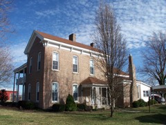 | Col. Thomas C. Love House | building | 1985 | 85000108 |
 | Rainey Funeral Home Building | building | 2014 | 13001112 |
Every wildfire the federal occurrence database records inside this county: 239 of them, burning about 4,434 acres. None started naturally and 24 were recorded as arson. Each settlement page carries the fires within five miles of it.
| Reported cause | Fires |
|---|---|
| Debris and open burning | 136 |
| Missing data/not specified/undetermined | 54 |
| Arson/incendiarism | 24 |
| Smoking | 10 |
| Equipment and vehicle use | 9 |
| Misuse of fire by a minor | 3 |
| Recreation and ceremony | 1 |
| Railroad operations and maintenance | 1 |
| Fireworks | 1 |
The five largest, by the area the report gives. One of them was set deliberately.
| Date | Cause | Size | Reported by | Name on the report |
|---|---|---|---|---|
| 23 March 2014 | Arson/incendiarism | 505 acres | Missouri Department of Conservation | not named |
| 22 April 2007 | Missing data/not specified/undetermined | 389 acres | Missouri Department of Conservation | FRIENDSHIP |
| 2 March 2006 | Missing data/not specified/undetermined | 254 acres | Missouri Department of Conservation | LEADMINE NORTH |
| 21 March 1995 | Missing data/not specified/undetermined | 225 acres | Missouri Department of Conservation | not named |
| 24 September 1999 | Debris and open burning | 170 acres | Missouri Department of Conservation | not named |
| 2 April 1997 | Debris and open burning | 150 acres | Missouri Department of Conservation | not named |
| 23 October 1999 | Debris and open burning | 150 acres | Missouri Department of Conservation | not named |
| 17 March 1995 | Missing data/not specified/undetermined | 150 acres | Missouri Department of Conservation | not named |
Every settlement page carries the fires within five miles of it - see the settlement index below.
The NOAA Storm Events Database holds 859 reports for this county, causing 5 deaths, 36 injuries and about $123,366,060 in recorded property damage. Each settlement page carries the reports that name it.
| Kind of event | Reports |
|---|---|
| Thunderstorm Wind | 275 |
| Hail | 249 |
| Flash Flood | 172 |
| Flood | 82 |
| Tornado | 40 |
| Heavy Rain | 33 |
| Funnel Cloud | 4 |
| Lightning | 3 |
| Wildfire | 1 |
The most serious of them, by death, then injury, then recorded damage. The accounts are quoted exactly as the forecast office filed them.
| When | Event | Place named | Harm | What the report says |
|---|---|---|---|---|
| January 2008 | Tornado (EF3) | Caddo | 2 killed, 6 hurt, $10,000,000 | This tornado is an extension of the Greene County tornado. A National Weather Service storm survey revealed that an EF-3 tornado tracked across northern Webster County and into southern Laclede County. Numerous homes and outbuildings were destroyed. Six injuries and two fatalities occurred in rural areas north of Marshfield. |
| February 2008 | Flash Flood | Cross Way | 1 killed, $250,000 | Numerous roads and low lying areas experienced flash flooding countywide. One fatality occurred as a 46 year old male drove his truck into the Finley River at a low water crossing southeast of Fordland. The river swept his truck off of the road. Other locations that experienced flooding in Webster County included a section of Clearwater Drive at Acorn Hills, a section of Battleclub Road at Normady Road, a section of Highway A north of its intersection with Elm Road, a section of Highway V at its intersection with the James River, a section of Highway FF at its intersection with Panther Creek, a section of Bell Springs Road near its intersection with Dry Creek, a section near the Bellford Bridge north of Fordland, and a section of Greenwood Road near Fordland. |
| May 1995 | Thunderstorm Wind | Fordland | 1 killed, $100,000 | Mobile homes in Rogersville, Fordland, and Seymour were destroyed by macrobursts. One macroburst to the northwest of Fordland produced an estimated 90 mph wind that destroyed a tied down mobile home and killed a 45 year old man. In Rogersville, 50 structures were heavily damaged. (M45M) |
| March 2023 | Flash Flood | Olga | 1 killed | A vehicle containing 3 occupants attempted to traverse a flooded low water crossing on Route Z at the Finley River. Two of the occupants were rescued safely but the driver did not survive, drowning as a result. |
| March 2006 | Tornado (F2) | Fordland | 13 hurt, $700,000 | no account filed |
| May 1990 | Tornado (F2) | not stated | 9 hurt | no account filed |
| May 1990 | Tornado (F0) | not stated | 3 hurt, $250,000 | no account filed |
| June 2007 | Flash Flood | Niangua | 3 hurt | Excessive rainfall caused significant flash flooding across much of the county. At a flooded roadway near Marshfield, a vehicle was swept off of the road. Three injuries resulted from this episode. |
| April 1967 | Tornado (F2) | not stated | 1 hurt, $25,000 | no account filed |
| April 1967 | Tornado (F1) | not stated | 1 hurt, $2,500 | no account filed |
| April 2026 | Hail | Elkland | $65,100,000 | A hail swath from a mile to 2 miles wide began south of Elkland and continued to the northeast across northern Webster County. Hail from quarters to hen eggs in size fell along a path from south of Elkland to west of Rader and south of Conway as a left moving supercell moved to the northeast across the County. Along the storms path, numerous homes, vehicles, businesses, equipment, crops, livestock and other structures were damaged by hail before the storm passed into southwestern Laclede County. |
| May 2024 | Hail | Marshfield | $12,500,000 | Hail sizes between 2 to 4 inches were reported across areas that included Marshfield. 300 homes at an average of $32,000 suffered damages to siding, roofs and windows, and 350 cars were damaged, including many in commercial car lots that had their windows broken. Commercial properties were also impacted, with Marshfield Pizza Hut for example had skylight windows broken. This estimated damage summary includes reports from other locations in the Marshfield area during this event. |
| May 2009 | Thunderstorm Wind | Caddo | $5,000,000 | Fifty to 85 mph wind gusts impacted nearly all of Webster County. Over 500 businesses and homes were damaged, meanwhile, hundreds of outbuildings were either damaged or destroyed. Tree damage was intense and widespread across all of the county. A communications tower owned by the Webster County Sheriff's Office was blown down near the community of Elkland. The ticket booth at Marshfield High School's football field along with the bus barn in Niangua were heavily damaged. |
| March 2008 | Flash Flood | Marshfield Bcknr Arp | $4,000,000 | Widespread rainfall amounts ranged from six to eight inches across Webster County. Record flooding occurred along the headwaters of the Finley and James rivers. Several homes flooded while all low areas that typically flood during periods of excessive rainfall flooded. Widespread road and bridge damage also occurred. Sections of Highway 60 between Rogersville and Seymore had to be closed. |
| July 2015 | Flash Flood | Olga | $3,000,000 | State Route Z at Finley Creek was flooded and closed. This storm report will contain the overall flood damage estimates across Webster County for this storm event. There were several episodes and heavy rainfall events which led to a compound affect to the flooding damage. Numerous roads, bridges, and low water crossings were heavily damaged. |
| August 2013 | Flash Flood | Rogersville | $2,500,000 | This storm report will include the total estimated damages due to the flooding event. Numerous low water crossings and roadways were flooded and severely damaged due to the flood waters across the county. Highway 60 along with several other roadways were flooded. |
| October 1984 | Tornado (F1) | not stated | $2,500,000 | no account filed |
| December 1982 | Tornado (F2) | not stated | $2,500,000 | no account filed |
| June 2024 | Flash Flood | Elkland | $2,000,000 | A significant flooding event occurred during the early morning hours of June 9th. Between 5-8 inches of rainfall fell across Webster County which caused the Pomme De Terre River, James River, Niangua River, Finley River, Gasconade River its tributaries to flood. There were damages to county bridges and roads which were estimated to be around 2 million dollars. |
| April 2017 | Flash Flood | Fordland | $1,000,000 | Numerous homes and business sustained flood damage across Webster County. Numerous roads and bridges were severely damaged or washed away across the county. This report will contain the total dollar estimate for flood damage to infrastructure, businesses, and homes across Webster County. |
| July 2015 | Flash Flood | North View Hill | $1,000,000 | Numerous roads were flooded and closed near the headwaters of the Pomme De Terre River. Roads that were closed included Cologna Road, Evergreen Road, and Cedar Ridge Road. This storm report will contain the overall storm damage estimates across Webster County for this storm event. Numerous roads, bridges, and low water crossings were heavily damaged. |
| December 2015 | Flash Flood | Crown | $1,000,000 | Numerous low water crossings and roads were flooded and impassable during the rain event. Numerous roads and bridges along with other infrastructure suffered damage across the county. A few homes and businesses also sustained flood water damage. This storm report will contain the damage estimates for the entire county for this event. |
| January 2008 | Tornado (EF2) | Holman | $1,000,000 | This is an extension of the Greene County tornado. A National Weather Service storm survey revealed that an EF-2 tornado tracked across rural west central Webster County and along the Interstate 44 corridor. The tornado lifted just prior to moving into Marshfield near York Road. Damage occurred to several homes and outbuildings. |
| May 1995 | Thunderstorm Wind | Rogersville | $1,000,000 | Mobile homes in Rogersville, Fordland, and Seymour were destroyed by macrobursts. One macroburst to the northwest of Fordland produced an estimated 90 mph wind that destroyed a tied down mobile home and killed a 45 year old man. In Rogersville, 50 structures were heavily damaged. (M45M) |
| January 2008 | Tornado (EF0) | Niangua | $750,000 | A National Wether Service storm survey revealed that an EF-2 tornado touched down over rural areas of eastern Webster County. Several homes and outbuildings were destroyed from this tornado. |
| August 2007 | Flash Flood | Marshfield | $600,000 | Excessive rainfall from Tropical Storm Erin continued across much of Webster County. This caused flash flooding on a section of Highway 38 nears its junction of Highway J, a section of Route DD near the Marshfield High School, a section of Evans Road, a bridge washed out on Route DD from flash flooding of the Osage Fork River, and a section of Highway A near its intersection with Highway FF. |
| June 2015 | Flash Flood | Crown | $500,000 | Highway A was flooded at the James River. The water was two feet over the bridge. This storm report will contain the overall storm damage estimates across the entire Webster County for this storm event. Numerous roads, bridges, and low water crossings were heavily damaged. |
| April 2011 | Flash Flood | Compton | $500,000 | A temporary bridge on New Hope Road north of Highway PP was washed away due to flooding.||The total cost estimate for flooding damages for Webster County for this entire episode has been included. This includes roads, bridges, and structures which were affected. |
| January 2008 | Flash Flood | Elkland | $500,000 | Training tornadic supercells caused major flash flooding at countless locations in Webster County. Numerous roads and low water crossings were washed away. Rainfall measurements ranged from 1.5 to 3.5 inches within a six hour time frame. A few locations that experienced this flooding include the intersection of Highway A and Highway FF. Several sections of Highway 60 between Rogersville and Diggins also experienced flooding. |
| April 1994 | Tornado (F1) | Marshfield | $500,000 | A tornado developed along County Road W three miles northwest of Marshfield with numerous reports of golf ball-size hail prior to touchdown. Two mobile homes were destroyed with debris spread one-half mile northeast. Several roofs near the mobile homes were destroyed or damaged and trees uprooted. The destruction pattern indicated that possibly two tornadoes could have occurred, or the single tornado moved very erratically. |
| May 2015 | Flash Flood | Compton | $260,000 | Highway KK was closed east of Compton Hollow Conservation Area due to flooding. There were several roads and low water crossings across Webster County that sustained damage due to flood water. This report will contain the total damage estimates for the entire county for this flood event. |
| March 2025 | Tornado (EF1) | Seymour | $250,000 | An EF1 tornado with maximum wind speeds of 100 mph started 5 miles north of Seymour and tracked northeast into Wright County. In Webster County the tornado ripped the roof off of a home, destroyed numerous barns, collapsed a train communication tower, and snapped trees. |
| June 2025 | Flash Flood | Forkners Hill | $250,000 | The bridge over the Niangua River at State Highway Y was washed out near Black Horse Rd. The road was closed. |
| December 2021 | Tornado (EF1) | Susanna | $250,000 | A National Weather Service storm survey concluded that an EF-1 tornado with maximum winds of 90 mph touched down southeast of Niangua and travelled northeast for just over 6 miles into Wright County before lifting a few miles west-southwest of Grovespring. This tornado damaged or destroyed numerous outbuildings, snapped or uprooted numerous trees, caused minor damage to a few homes as well as flipping an RV camper as it moved across western Webster County before entering Wright County east of State Highway AC and South of State highway M. |
| June 2015 | Flood | Crown | $250,000 | There were 4 homes in western Webster County near Highway KK that had several feel of flood water in the residence. These homes had never flooded in the past. |
| April 1996 | Thunderstorm Wind | Marshfield | $250,000 | no account filed |
| May 1998 | Thunderstorm Wind | Northview | $200,000 | The same thunderstorm that hit Greene county moved east and brought estimated 70 knots wind gusts in a path from Northview to Marshfield. Numerous trees were down and windows at two homes were blown out. A storage building was destroyed at the Marshfield High School. Winds also damaged a greenhouse. |
| February 2001 | Tornado (F1) | Seymour | $155,000 | no account filed |
| April 2019 | Thunderstorm Wind | Zenar | $125,000 | Significant damage was reported to industrial buildings with sheet metal peeled off and blown towards the east and southeast. A National Weather Service survey indicated that the degree of damage was caused by 70 mph straight line winds. |
| April 2025 | Tornado (EF0) | High Prairie | $100,000 | A National Weather Service Survey determined that an EF0 tornado developed at 4:46PM April 20, 2025 northwest of High Prairie, MO and tracked to the northeast for a little over one mile lifting at 4:48pm. Peak winds were 80mph with a max width of 30 yards. Several barns were damaged along with several trees and limbs downed along the path. |
| July 2015 | Thunderstorm Wind | Elkland | $100,000 | Over 100 trees were uprooted or snapped off. Power line poles were snapped halfway up. Extensive power lines were blown down. Dozen of trees were on homes. Some shingles and roofs were blown off. Several barns were collapsed and blown away over a great distance. |
| December 2010 | Tornado (EF0) | Olga | $100,000 | A NWS survey team confirmed the EF-1 tornado that touched down in Christian County diminished to EF-0 intensity as it tracked into Webster County. There were numerous trees uprooted and outbuildings damaged. |
| June 2005 | Thunderstorm Wind | Rogersville | $100,000 | Severe thunderstorm straight line winds caused structural and tree damage to areas of southern Webster County along Highway 60. The Rogersville area sustained the heaviest damage with houses and businesses receiving minor damage. Several business signs were damaged or destroyed. |
| April 1996 | Tornado (F0) | Seymour | $100,000 | no account filed |
| December 2018 | Tornado (EF1) | Seymour | $90,000 | An EF-1 tornado formed 2 miles north northeast of Seymour and tracked northeast and dissipated approximately 6 miles northeast of Seymour. There was significant damage to barns along with uprooted trees along the tornadoes path. |
| March 2023 | Thunderstorm Wind | Sarvis Pt | $80,000 | Roof damage was reported to several barns and a residence in the Sarvis Point Road area. |
| July 2023 | Thunderstorm Wind | North View Hill | $75,000 | Multiple large trees were uprooted or snapped. Shingle and siding damage occurred to several out building an at least one home. |
| September 2010 | Thunderstorm Wind | Rogersville | $75,000 | A NWS storm survey team determined that a microburst, with estimated 90 mph winds, destroyed a large barn and uprooted several trees around a House on Highway B in the northern part of Rogersville. Several other trees were blown onto houses and vehicles. |
| February 1999 | Thunderstorm Wind | Marshfield | $70,000 | no account filed |
| August 2020 | Thunderstorm Wind | Diggins | $60,000 | Multiple large tree limbs were reported down across town. Several reported of garage doors blown in and outbuildings damaged also occurred. |
| October 2025 | Lightning | Rogersville | $50,000 | Two barns and a home were reported to have been struck by lightning. Small fires occurred with the barns and the front porch of the home partially collapsed. |
| May 2020 | Thunderstorm Wind | Seymour | $50,000 | Roofs and awnings of building on the town square of Seymour suffered moderate damage from high winds. Falling debris also damaged vehicles. |
| July 2015 | Thunderstorm Wind | Niangua | $50,000 | Several mobile homes were blown off their piers in a trailer park on Plank School Road. |
| May 2009 | Tornado (EF1) | Fordland | $50,000 | A National Weather Service storm survey revealed that an EF-1 tornado touched down near Highway 60 approximately one mile east of Fordland, and tracked northeast to near Diggins Road. The tornado damaged a delivery truck, a roof off the Memory Lane Dairy Farm, several trees, and an outbuilding on Diggins Road. |
| January 2008 | Tornado (EF1) | Beach | $50,000 | A National Weather Service storm survey revealed that an EF-1 tornado touched down in rural northwest Webster County and tracked into southern Dallas County. The tornado damaged one home and several outbuildings. |
| November 2004 | Tornado (F1) | Northview | $50,000 | A tornado that developed along a line of weak showers destroyed three barns and damaged a house over rural Webster County. The tornado was on the ground for approximately six miles, and downed numerous trees along it's path. The average path width was approximately 500 yards wide, however, the path width maxed out at one quarter of a mile wide near Land Slide Road. |
| April 2026 | Thunderstorm Wind | Rogersville | $40,000 | Several trees and large limbs were reported down with some limbs on powerlines. |
| April 2025 | Thunderstorm Wind | Forkners Hill | $40,000 | Multiple trees and powerlines were reported down. |
| April 2023 | Thunderstorm Wind | High Prairie | $40,000 | Damage was reported to a large 40 foot by 50 foot section of a metal construction building. Metal was peeled back or removed. |
| April 2019 | Thunderstorm Wind | Olga | $40,000 | Several power lines and poles were reported down on State Highway Z, south of Fordland. |
The Survey's mineral resources record lists 31 workings inside this county. 1 still produces and 30 are closed or unrecorded. Each settlement page carries the workings within five miles of it.
| Commodity | Workings |
|---|---|
| Stone, Crushed/Broken | 12 |
| Lead | 9 |
| Lead, Zinc | 6 |
| Iron | 2 |
| Zinc | 1 |
| Bituminous, Zinc | 1 |
The least common of them first, because a county's hundredth gravel pit says nothing its first ten did not.
| Where | Site | Commodity | Status | Recorded |
|---|---|---|---|---|
| Marshfield Shaft | Bituminous, Zinc | Past Producer | ||
| Unknown - Zinc | Zinc | Past Producer | ||
| Unknown - Iron | Iron | Past Producer | ||
| Unknown - Iron | Iron | Past Producer | ||
| Gates Mine | Lead, Zinc | Past Producer | ||
| Harper Mines | Lead, Zinc | Past Producer | ||
| Star Mines | Lead, Zinc | Past Producer | ||
| Unknown - Lead & Zinc | Lead, Zinc | Past Producer | ||
| Unknown - Lead & Zinc | Lead, Zinc | Past Producer | ||
| Unknown - Lead & Zinc | Lead, Zinc | Past Producer | ||
| Hazelwood Diggings | Lead | Past Producer | ||
| Jackson Mine | Lead | Past Producer | ||
| Mcclurgs Place | Lead | Past Producer | ||
| Teague Creek Mines | Lead | Past Producer | ||
| Trusty Mines | Lead | Past Producer | ||
| Unknown - Lead | Lead | Past Producer | ||
| Unknown - Lead | Lead | Past Producer | ||
| Unknown - Lead | Lead | Past Producer | ||
| Unknown - Lead | Lead | Past Producer | ||
| Unknown - Ls | Stone, Crushed/Broken | Past Producer | ||
| Unknown - Ls | Stone, Crushed/Broken | Past Producer | ||
| Unknown - Ls | Stone, Crushed/Broken | Past Producer | ||
| Unknown - Ls | Stone, Crushed/Broken | Past Producer | ||
| Unknown - Ls | Stone, Crushed/Broken | Past Producer | ||
| Unknown - Ls | Stone, Crushed/Broken | Past Producer | ||
| Unknown - Ls | Stone, Crushed/Broken | Past Producer | ||
| Unknown - Ls | Stone, Crushed/Broken | Past Producer | ||
| Unknown - Ls | Stone, Crushed/Broken | Past Producer | ||
| Unknown - Ls | Stone, Crushed/Broken | Past Producer | ||
| Unknown - Ls | Stone, Crushed/Broken | Past Producer | ||
| Webster County Quarry | Stone, Crushed/Broken | Producer |
Named settlements recorded in the Geographic Names Information System, each with the topographic sheets covering it. Villages, hamlets and abandoned places alike. Each is shown with the nearest named watercourse or landform and the survey quadrangle it falls on.
Northview township · 65706 · On Turnbo Creek · Marshfield quadrangle
13 sheets, 1946 to 1983
Benton township · 65757 · On Compton Branch · Oak Grove Heights quadrangle
21 sheets, 1884 to 1982
No longer a settlement
Finley township · 65746 · Mansfield NW quadrangle
12 sheets, 1951 to 1985
No longer a settlement
Benton township · 65742 · Near White Oak Hollow · Oak Grove Heights quadrangle
21 sheets, 1884 to 1982
High Prairie township · 65713 · Duncan quadrangle
12 sheets, 1954 to 1983
No longer a settlement
Niangua township · 65713 · On Bracken Creek · High Prairie quadrangle
13 sheets, 1946 to 1983
Northview township · 65706 · On Clubhouse Creek · Marshfield quadrangle
13 sheets, 1946 to 1983
Northview township · 65706 · Near North View Hill · Marshfield quadrangle
13 sheets, 1946 to 1983
Benton township · 65652 · On Dry Fork · Oak Grove Heights quadrangle
21 sheets, 1884 to 1982
Northview township · 65706 · Near North View Hill · Strafford quadrangle
20 sheets, 1884 to 1982
Benton township · 65742 · Near White Oak Hollow · Rogersville quadrangle
23 sheets, 1884 to 1982
Finley township · 65746 · On Silvey Branch · Dogwood quadrangle
14 sheets, 1939 to 1983
The vanished settlements of Webster County: the places named above that are no longer on the map.