 Block
From the record
One of 13 National Register listings published here for Newton County · listed in 2007 · category: District.
Sources: the case file at the National Archives · the National Register database, National Park Service
Listed on the National Register of Historic Places in 2007.
One of 13 National Register listings published here for Newton County · listed in 2007 · category: District.
Sources: the case file at the National Archives · the National Register database, National Park Service
Regional context, not property-specific evidence. The federal wildfire occurrence database lists 375 fires within 5 miles of Neosho Commercial Historic District (Boundary Increase) between 1992 and 2020, burning about 752 acres in total. 1 started naturally. 11 were recorded as arson. Distance is straight-line from the map coordinates, so a fire counted here may appear on a neighbouring settlement's page as well.
| Reported cause | Fires |
|---|---|
| Debris and open burning | 183 |
| Missing data/not specified/undetermined | 123 |
| Equipment and vehicle use | 23 |
| Recreation and ceremony | 23 |
| Arson/incendiarism | 11 |
| Smoking | 5 |
| Railroad operations and maintenance | 3 |
| Power generation/transmission/distribution | 2 |
| Natural | 1 |
| Fireworks | 1 |
The most recent of them, most recent first, with the day each was reported and the service that recorded it.
| Date | Cause | Size | Reported by | Name on the report |
|---|---|---|---|---|
| 9 September 2011 | Missing data/not specified/undetermined | 1.0 acres | Missouri Department of Conservation | not named |
| 9 September 2000 | Missing data/not specified/undetermined | 1.0 acres | Missouri Department of Conservation | not named |
| 4 September 2014 | Equipment and vehicle use | 1.0 acres | Missouri Department of Conservation | not named |
| 4 September 2000 | Missing data/not specified/undetermined | 1.0 acres | Missouri Department of Conservation | not named |
| 4 September 2000 | Smoking | 2.0 acres | Missouri Department of Conservation | not named |
| 4 September 2000 | Missing data/not specified/undetermined | 1.0 acres | Missouri Department of Conservation | not named |
| 30 September 2017 | Missing data/not specified/undetermined | under an acre | Missouri Department of Conservation | not named |
| 29 September 2020 | Debris and open burning | under an acre | Missouri Department of Conservation | 230911-07334-09292020-1750 |
Regional context, not property-specific evidence. The federal mineral resources record lists 17 workings within 5 miles of Neosho Commercial Historic District (Boundary Increase): 17 past producers. None of them still produces. What was taken out: Stone, Crushed/Broken, Lead, Zinc, Zinc, Lead, Sand and Gravel, Construction. Distance is straight-line from the map coordinates, so a quarry counted here may appear on a neighbouring settlement's page as well.
| Where | Site | Commodity | Status | Recorded |
|---|---|---|---|---|
| Booth Ryan & Co. Mine | Lead | Past Producer | ||
| Lt. George Chase Shaft | Zinc | Past Producer | ||
| Unknown - S&G | Sand and Gravel, Construction | Past Producer | ||
| Granby Ore Block 10 | Zinc, Lead | Past Producer | 1850, 1853 | |
| Granby Ore Block 109 | Zinc, Lead | Past Producer | 1850, 1853 | |
| Unknown - Zn & Pb | Zinc, Lead | Past Producer | ||
| Granby Ore Block 108 | Lead, Zinc | Past Producer | 1850, 1853 | |
| Granby Ore Block 8 | Lead, Zinc | Past Producer | 1850, 1853 | |
| Johnson Lease | Lead, Zinc | Past Producer | ||
| Unknown - Zn & Pb | Lead, Zinc | Past Producer |
Regional context, not property-specific evidence. The National Weather Service names Neosho, the town this property stands in, in 261 storm reports between 1993 and 2025: 87 hail, 77 flash flood, 71 thunderstorm wind, 11 flood. The reports record 3 injuries. Each account below is quoted exactly as the forecast office filed it, from the NOAA Storm Events Database, and each date opens the federal record of that event.
| When | Event | Place named | Harm | What the report says |
|---|---|---|---|---|
| June 2014 | Thunderstorm Wind | Neosho | 2 hurt, $10,000 | Damaging winds blew down several firework tents. Two minor injuries were reported. Several trees were also blown down in the county. |
| March 2006 | Tornado (F1) | Neosho | 1 hurt, $200,000 | A supercell thunderstorm tracked out of Ottawa County, Oklahoma and into Newton County, Missouri. The storm spawned a tornado approximately 8 miles SW of Neosho and damaged around 40 structures across rural sections of the county. The tornado also struck a turkey farm killing around 200 turkeys prior to lifting approximately one mile west of Neosho. |
| April 2001 | Tornado (F1) | Neosho | $4,000,000 | no account filed |
| December 2015 | Flood | Neosho | $2,000,000 | Multiple rail cars floated off of the tracks due to flooding of Shoal Creek. At least three families were stranded by high water. Several homes sustained flood damage. Several mobile homes were washed away by flooding along Shoal Creek near Reddings Mill. Numerous roads and low water crossings suffered flood damage. This storm report will contain the damage estimates for the entire county for this event. |
| July 2015 | Flood | Neosho | $500,000 | The bridge at East Coler and Dean Keeling Drive was flooded by Hickory Creek. This storm report will contain the overall flood damage estimates across Newton County for this storm event. There were several episodes and heavy rainfall events which led to a compound affect to the flooding damage. Numerous roads, bridges, and low water crossings were heavily damaged. |
| May 2011 | Flash Flood | Neosho | $500,000 | Numerous homes in the Neosho and Seneca were flooded and evacuated. Widespread flash flooding was reported across the county with numerous roads impassable. |
| May 2017 | Tornado (EF0) | Neosho | $50,000 | An EF-1 tornado touched down along Highway 60 on the north side of Neosho. Numerous trees were damaged along the path. A few homes were damaged. Estimated maximum winds were up to 95 mph. |
| June 2014 | Thunderstorm Wind | Neosho | $50,000 | Numerous trees were blown down and several vehicles were damaged due to large limbs falling on them. |
| August 2011 | Lightning | Neosho | $50,000 | Lightning struck a vacant grocery store. The store caught fire and was destroyed. |
| July 2023 | Thunderstorm Wind | Neosho | $40,000 | Multiple large limbs and several power poles were reported down. |
| June 2009 | Thunderstorm Wind | Neosho | $35,000 | Thunderstorm wind gusts caused roof damage to a manufacturing plant in Neosho. Large tree limbs were downed in this area as well. |
| July 2009 | Thunderstorm Wind | Neosho | $35,000 | Severe thunderstorm winds damaged the doors at a Lowe's and downed several power lines. |
| August 2020 | Thunderstorm Wind | Neosho | $30,000 | Power lines were reported down causing several power outages. |
| June 2024 | Thunderstorm Wind | Neosho | $20,000 | A roof was blown off a building in Neosho. |
| March 2010 | Hail | Neosho | $20,000 | no account filed |
| June 2005 | Hail | Neosho | $20,000 | no account filed |
| June 2003 | Flash Flood | Neosho | $20,000 | no account filed |
| July 2016 | Thunderstorm Wind | Neosho | $15,000 | A tree was blown down on to a car at the Newton County Fairgrounds. |
| May 2024 | Hail | Neosho | $10,000 | Report of hen egg size hail. |
| July 2023 | Thunderstorm Wind | Neosho | $10,000 | Tree limbs of at least 3 inches in diameter and at least one power pole were downed by high winds. |
| July 2023 | Thunderstorm Wind | Neosho | $10,000 | Tree limbs of at least 3 inches in diameter and at least one power pole were downed by high winds. |
| November 2020 | Thunderstorm Wind | Neosho | $10,000 | Law enforcement reported a measured wind gust of 61mph along with power outages in town. |
| September 2012 | Thunderstorm Wind | Neosho | $10,000 | Power outages were reported through out Newton County. Numerous trees and power poles were down. |
| July 2010 | Flash Flood | Neosho | $10,000 | Widespread street flooding was reported in the city of Neosho. Several cars were pushed off of roadways by high water. |
| March 2006 | Tornado (F0) | Neosho | $10,000 | From the same supercell thunderstorm that produced the F-1 tornado across rural southwest Newton County, a weak tornado briefly touched down in a neighborhood on the western edge of Neosho. One house sustained significant roof damage. |
| May 1995 | Thunderstorm Wind | Neosho | $10,000 | A severe thunderstorm produced one inch hail and blew the roofs off of homes and the Masonic Lodge in Neosho. |
| June 1995 | Thunderstorm Wind | Neosho | $10,000 | Thunderstorm winds downed power lines. |
| April 2001 | Thunderstorm Wind | Neosho | $10,000 | no account filed |
| May 1997 | Flash Flood | Neosho | $10,000 | no account filed |
| September 2021 | Thunderstorm Wind | Neosho | $5,000 | Multiple trees along a 40 acre field were blown down on a fence. and minor roof damage occurred to a home. |
| June 2018 | Thunderstorm Wind | Neosho | $5,000 | Two large trees and several power lines were downed by high winds. |
| April 2016 | Thunderstorm Wind | Neosho | $5,000 | Several power lines were blown down at Interstate 49 and Highway 60 in Neosho. |
| September 2012 | Thunderstorm Wind | Neosho | $5,000 | A tree fell on a truck. |
| April 2009 | Thunderstorm Wind | Neosho | $5,000 | Thunderstorm wind gusts blew a roof off of a structure along Highway 59. |
| August 2006 | Thunderstorm Wind | Neosho | $5,000 | Severe thunderstorm wind gusts stripped siding off of a building. |
| July 1997 | Thunderstorm Wind | Neosho | $5,000 | Thunderstorm winds from a microburst downed trees and damaged two outbuildings. In addition, windows on a pickup truck were broken by fallen debris. |
| August 2002 | Thunderstorm Wind | Neosho | $5,000 | no account filed |
| March 1997 | Thunderstorm Wind | Neosho | $5,000 | no account filed |
| September 1993 | Hail | Neosho | $5,000 | no account filed |
| October 2019 | Thunderstorm Wind | Neosho | $3,500 | A broken power pole with wires laying across a driveway was reported. |
| May 2024 | Thunderstorm Wind | Neosho | $3,000 | Report of broken tree limbs and power poles. |
| May 2024 | Thunderstorm Wind | Neosho | $3,000 | Report of tree limbs and power poles broken. |
| June 2023 | Thunderstorm Wind | Neosho | $3,000 | Several large trees were uprooted and large limbs were downed. A few limbs damaged outbuilding roofs. |
| June 2010 | Lightning | Neosho | $3,000 | Lightning from severe thunderstorms struck the sheriff's office which damaged equipment and disrupted communications. |
| September 1999 | Thunderstorm Wind | Neosho | $3,000 | no account filed |
| June 2024 | Thunderstorm Wind | Neosho | $2,000 | A 59mph wind gust was measured in Neosho. Some trees were damaged in Neosho. |
| May 2020 | Flash Flood | Neosho | $2,000 | Several roads in Neosho and in the southern part of the county were flooded and barricaded. The Neosho Fire Department evacuated people from along Hickory Creek due to rapidly rising flood waters. |
| February 2019 | Thunderstorm Wind | Neosho | $2,000 | Three trees were blown down from severe thunderstorm wind gusts. One house near Granby had shingles blown off. |
| May 2017 | Thunderstorm Wind | Neosho | $2,000 | Several power lines were blown down on High Street. |
| May 2017 | Thunderstorm Wind | Neosho | $2,000 | Several trees and power lines were blown down in the Neosho area. |
| August 2015 | Thunderstorm Wind | Neosho | $2,000 | Several power lines were blown down in Neosho. |
| October 2010 | Thunderstorm Wind | Neosho | $2,000 | A tree fell on power lines and caught fire at the intersection of Summit Road and Reid Road. |
| August 1997 | Thunderstorm Wind | Neosho | $2,000 | Thunderstorm winds downed trees and power lines. |
| August 1997 | Thunderstorm Wind | Neosho | $2,000 | Thunderstorm winds downed trees and power lines. |
| June 2025 | Thunderstorm Wind | Neosho | $1,000 | A tree was downed in Neosho. |
| April 1994 | Hail | Neosho | $50 | no account filed |
| April 2025 | Thunderstorm Wind | Neosho | - | Heavy rain and winds estimated from 50-60 mph was reported. |
| June 2025 | Heavy Rain | Neosho | - | A one hour rainfall total of 1.18 inches fell in Neosho. |
| May 2024 | Hail | Neosho | - | Report of golf ball size hail in Neosho on Highway 86. |
| May 2024 | Hail | Neosho | - | Mping report of quarter size hail. |
No historic map-sheet match is published for this property yet. That does not mean no map exists. This record needs a coordinate-quality review before it can be joined to a sheet boundary. Browse the county's mapped places while that work is pending.
Other National Register properties close enough to walk or drive between, ordered by distance from this one. Both positions come from the same geocoding pass that matched these properties to their map sheets.
| Photograph | Property | Distance | Listed |
|---|---|---|---|
 | Neosho Commercial Historic District | under 500 feet | 1993 |
 | Neosho High School | 0.2 miles | 2002 |
 | Neosho Wholesale Grocery Company | 0.3 miles | 2013 |
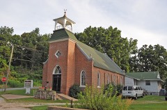 | Second Baptist Church | 0.5 miles | 1996 |
| Neosho Colored School | 0.6 miles | 2017 |
| National Archives record | The nomination case file for reference 07000323 in Record Group 79. |
| Newton County | All 13 listed properties in this county. |