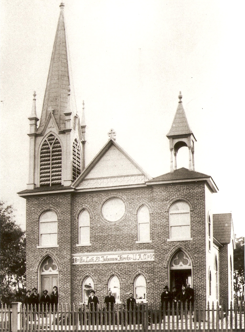
St. John's Evangelical Lutheran Church and Parochial School
Listed on the National Register of Historic Places in 2008.
From the record
“John's Evangelical Lutheran Church is an historic Lutheran church located in Corning, Missouri. It was founded as a Confessional Church, adhering to the Unaltered Augsburg Confession.”
Wikipedia article St. John's Evangelical Lutheran Church (Corning, Missouri), CC BY-SA 4.0.
One of 4 National Register listings published here for Holt County · listed in 2008 · category: Building.
National Register reference number.07001339- the number the National Park Service assigned this property when it was listed, and the key its nomination file is catalogued under at the National Archives.
The first attempt to start a town in this part of the county was inaugurated by Henry Hemme, another Hanoverian, who settled in the country in 1844. This settlement, which was known as Hemme's Landing, was about two miles west of the site of the present town of Corning. Its site is now within the limits of the State of Nebraska, and the Missouri River flows within three-fourths of a mile of Corning, and considerably to the eastward of the spot where the old town once stood. At^ne time Hemme's Landing was one of the most important trading points between St. Joseph and Council Bluffs. The first merchant who sold goods at the landing was David Greer, who commenced business there in 1845. He was shortly after succeeded by Henry Hemme, who in 1847, gave place to Vernile Thompson. In 1848, Robert Hawke bought out Thompson.
This town, the most northern of Holt County, and less than one mile south of the line of Atchison County, was laid out in the fall of 1868. Its original site occupied the northwest quarter of the northeast quarter of section 30, township 63, range 40. Martin's Addition, adjoining on the north, was laid out in the spring of 1869, by Horace Martin, of Crawford County, Ohio, a gentleman of distinguished scientific attainments, and long and honored member and colaborator of the Smithsonian Institute of Washington, D. C., and observer in the employ of the United States Signal Service. Mr. Martin was one of the earliest settlers of the town of Corning, having settled there in the month of October, 1868. The site of the town, which is in the bottom, about two miles westward of the bluff, is 893 feet above the level of the sea. It is 51 miles from St. Joseph, and 77 miles from Council Bluffs. During the period of the flood of 1881, Corning suffered severely from the overflow.
Regional context, not property-specific
evidence. The
federal wildfire occurrence database
lists 10 fires within 5 miles of St. John's Evangelical Lutheran Church and Parochial School
between 2009 and 2020, burning about 85 acres in total. None started naturally. None was recorded as arson.
Distance is straight-line from the map coordinates, so a fire counted
here may appear on a neighbouring settlement's page as well.
Reported cause
Fires
Missing data/not specified/undetermined
5
Equipment and vehicle use
3
Debris and open burning
2
The most recent of
them, most recent first, with the day each was reported and the service
that recorded it.
Regional context, not property-specific
evidence. The federal mineral resources record lists
2 workings within 5 miles of St. John's Evangelical Lutheran Church and Parochial School: 2 past producers.
None of them still produces. What was taken out: Stone, Crushed/Broken, Sand and Gravel, Construction. Distance is straight-line from the
map coordinates, so a quarry counted here may appear on a neighbouring
settlement's page as well.
Regional context, not property-specific
evidence. The National Weather Service names
Corning, the town this property stands in, in 13 storm reports between 1994 and 2024: 6 hail, 4 thunderstorm wind, 2 flood, 1 tornado.
No death or injury is recorded in these reports. Each account below is quoted exactly as the forecast office
filed it, from the NOAA Storm Events Database, and each date
opens the federal record of that event.
This tornado developed in Richardson County, Nebraska, and tracked northeast crossing the Missouri River into Holt County in Missouri(see Storm Data for Nebraska, East, for more information on the beginning portion of this tornado in Nebraska)at 1849CST, 3.45 miles southwest of Corning. In Missouri, the most significant damage, rated EF1, was to several barns and out buildings, one residence, and two destroyed trailers. The tornado crossed into Atchison County at 1859CST, around 3.6 miles east of Corning.
Once the Missouri River started flooding on March 9, it remained in flood through the remainder of the month. The gauge in Rulo, Nebraska - along the west bank of the Missouri River - reached 28.14 feet on March 20 (preliminarily a new record). The flooding was caused by several rounds of heavy snow across the Northern Plains through the winter months, followed by a rapid warm-up and several days of heavy rain. The Missouri River Basin across the Northern Plains flooded with catastrophic consequences as numerous dams and levees failed. As the water flowed into the Missouri River upstream of Holt County, the river swelled and ultimately overwhelmed the levees along the river. Most the worst damage occurred near Craig, when a nearby levee failed and inundated the city with several inches of water. Local fields were also submerged, which delayed the growing season in the region. Several roads were washed away across Holt County, and I-29 from St. Joseph northward to the Iowa/Missouri border was closed until mid May. Note: The dollar valued assigned to this event is likely inaccurate as a full tally of the extent of the physical damages is unknown. The Missouri River remained in flood through the rest of the month, into April.
Heavy spring rains caused ongoing flooding along the Missouri River to Continue through the month. Some locations along the Missouri River experienced major flooding at times during the month. Damage estimates from roads washed out and crop damage are unknown at this time.
No historic map-sheet match is published
for this property yet. That does not mean no map exists. This record needs
a coordinate-quality review before it can be joined to a sheet boundary.
Browse the county's mapped places while that work is
pending.
Listing record. National Park Service National Register of Historic Places, listed-properties dataset, current to 2026-05-22.
Map join. Address geocoded through the United States Census geocoder, then tested against the published boundary of every sheet in the USGS Historical Topographic Map Collection.
How this page is made. Listing fields come from federal records; map-sheet coverage is a labelled coordinate-to-boundary calculation, not a source-field claim.
Wildfire. Short, Karen C. 2022. Spatial wildfire occurrence data for the United States, 1992-2020 [FPA_FOD_20221014]. 6th Edition. Fort Collins, CO: Forest Service Research Data Archive. https://doi.org/10.2737/RDS-2013-0009.6 Collected with United States Government funding and usable without additional permissions or fees.
Mines and quarries. USGS Mineral Resources Data System (MRDS) https://mrdata.usgs.gov/mrds/ A work of the United States government, no copyright under 17 U.S.C. 105.
Storms. NOAA National Centers for Environmental Information, Storm Events Database https://www.ncei.noaa.gov/stormevents/ A work of the United States government, no copyright under 17 U.S.C. 105. Narratives are quoted verbatim from the National Weather Service report and are not edited or summarised.
 Block