 Block
From the record
One of 5 National Register listings published here for Randolph County · listed in 2022 · category: Building.
Sources: the National Register database, National Park Service
Listed on the National Register of Historic Places in 2022.
One of 5 National Register listings published here for Randolph County · listed in 2022 · category: Building.
Sources: the National Register database, National Park Service
Regional context, not property-specific evidence. The federal wildfire occurrence database lists 35 fires within 5 miles of Commerce Bank between 1999 and 2020, burning about 133 acres in total. None started naturally. None was recorded as arson. Distance is straight-line from the map coordinates, so a fire counted here may appear on a neighbouring settlement's page as well.
| Reported cause | Fires |
|---|---|
| Missing data/not specified/undetermined | 17 |
| Debris and open burning | 10 |
| Smoking | 4 |
| Equipment and vehicle use | 3 |
| Power generation/transmission/distribution | 1 |
The most recent of them, most recent first, with the day each was reported and the service that recorded it.
| Date | Cause | Size | Reported by | Name on the report |
|---|---|---|---|---|
| 24 September 2004 | Debris and open burning | under an acre | Missouri State Fire Marshal's Office | not named |
| 24 August 2014 | Equipment and vehicle use | 1.0 acres | Missouri Department of Conservation | not named |
| 23 August 2017 | Missing data/not specified/undetermined | under an acre | Missouri Department of Conservation | not named |
| 7 July 1999 | Missing data/not specified/undetermined | 20 acres | Missouri Department of Conservation | not named |
| 4 July 2020 | Equipment and vehicle use | 35 acres | Missouri Department of Conservation | 210552-08854-07042020-1440 |
| 3 July 2001 | Debris and open burning | 1.0 acres | Missouri Department of Conservation | not named |
| 21 July 2018 | Smoking | 1.9 acres | Missouri Department of Conservation | 178099-08853-07212018-2030 |
| 14 July 2001 | Missing data/not specified/undetermined | 1.0 acres | Missouri Department of Conservation | not named |
Regional context, not property-specific evidence. The federal mineral resources record lists 20 workings within 5 miles of Commerce Bank: 19 past producers, 1 producer. 1 still produces. What was taken out: Stone, Crushed/Broken, Clay. Distance is straight-line from the map coordinates, so a quarry counted here may appear on a neighbouring settlement's page as well.
| Where | Site | Commodity | Status | Recorded |
|---|---|---|---|---|
| Unknown - Shale | Clay | Past Producer | ||
| Quality Stone Material Qry/Mill | Stone, Crushed/Broken | Producer | ||
| Unknown - Limestone | Stone, Crushed/Broken | Past Producer | ||
| Unknown - Limestone | Stone, Crushed/Broken | Past Producer | ||
| Unknown - Limestone | Stone, Crushed/Broken | Past Producer | ||
| Unknown - Limestone | Stone, Crushed/Broken | Past Producer | ||
| Unknown - Limestone | Stone, Crushed/Broken | Past Producer | ||
| Unknown - Limestone | Stone, Crushed/Broken | Past Producer | ||
| Unknown - Limestone | Stone, Crushed/Broken | Past Producer | ||
| Unknown - Limestone | Stone, Crushed/Broken | Past Producer |
Regional context, not property-specific evidence. The National Weather Service names Moberly, the town this property stands in, in 85 storm reports between 1993 and 2025: 42 thunderstorm wind, 34 hail, 8 flash flood, 1 tornado. No death or injury is recorded in these reports. Each account below is quoted exactly as the forecast office filed it, from the NOAA Storm Events Database, and each date opens the federal record of that event.
| When | Event | Place named | Harm | What the report says |
|---|---|---|---|---|
| July 1995 | Tornado (F3) | Moberly | $400,000 | A tornado touched down south of Moberly then moved through the eastern half of town. The tornado lifted approximately seven miles northeast of Moberly. |
| September 2004 | Flash Flood | Moberly | $20,000 | A thunderstorm produced torrential rains in a short period of time around the city of Moberly. Numerous homes and businesses sustained water damage. There were also several water rescues for stranded motorists. |
| April 2011 | Thunderstorm Wind | Moberly | $15,000 | A tractor trailer was blown over just south of town. A roof was blown off a house on Route JJ just west of town. Thunderstorm wind gusts were estimated up to 70 mph. |
| May 2005 | Thunderstorm Wind | Moberly | $10,000 | Several large trees were knocked down by thunderstorm winds with one large tree falling on a residential roof and nearby parked van. Also a backup communication tower for an ambulance company toppled over. |
| June 2011 | Thunderstorm Wind | Moberly | $2,000 | Thunderstorm wind gusts were estimated up to 70 mph. Electricity is out and branches and power lines have been blown down. |
| November 1998 | Thunderstorm Wind | Moberly | $2,000 | Several large trees were downed and two highway road signs were blown over by the strong winds. |
| May 2012 | Thunderstorm Wind | Moberly | $1,000 | Thunderstorm wind gusts were estimated up to 60 mph. The wind snapped off a two and a half foot diameter tree. The tree fell against a power pole and brought it and a power line down. |
| June 2025 | Thunderstorm Wind | Moberly | - | Downed tree and wires near Logan Street in Moberly. |
| June 2025 | Thunderstorm Wind | Moberly | - | Downed tree and wires near Halleck Street. |
| June 2025 | Thunderstorm Wind | Moberly | - | Downed wires near Reed Street. |
| June 2024 | Thunderstorm Wind | Moberly | - | Downed wires southwest of Moberly. |
| July 2023 | Thunderstorm Wind | Moberly | - | Estimated wind gusts up to 60 mph in Moberly with tree limbs downed. |
| June 2020 | Thunderstorm Wind | Moberly | - | Several 5 inch diameter tree limbs broke off a healthy tree. |
| March 2018 | Flash Flood | Moberly | - | Several vehicles were stalled under the rail bridge on Route 63 in Moberly. |
| August 2018 | Hail | Moberly | - | Golf ball sized hail produced some damage to the siding. |
| August 2018 | Thunderstorm Wind | Moberly | - | Large tree limbs and power lines were down near Moberly. |
| July 2017 | Thunderstorm Wind | Moberly | - | Winds of 60-70 mph were reported by the public near Moberly. |
| June 2016 | Thunderstorm Wind | Moberly | - | Fire Station 2 in Moberly lost part of its roof and a tree was down blocking County Road 2360. |
| August 2016 | Thunderstorm Wind | Moberly | - | A storage building lost part of its roof and a shed was blwon into the street. Winds were estimated around 60 to 70 mph. |
| July 2016 | Thunderstorm Wind | Moberly | - | Power was out in Moberly due to several trees of unknown size or condition being down across the town. |
| June 2015 | Thunderstorm Wind | Moberly | - | Near Moberly a shed was blown away and a large 35 to 40 foot ball tree was blown down from winds that local AWOS reported as 68 mph. |
| June 2015 | Thunderstorm Wind | Moberly | - | Several trees were damaged near Moberly between the town and route YY from AWOS measured 68 mph winds. |
| July 2015 | Thunderstorm Wind | Moberly | - | Winds were estimated to be 60 mph. |
| July 2015 | Thunderstorm Wind | Moberly | - | Sixty mph winds were estimated in the town of Moberly, MO. The winds knocked down a tree blocking Morley Street. |
| June 2015 | Thunderstorm Wind | Moberly | - | A member of the public reported a 60 mph wind gust. |
| July 2014 | Thunderstorm Wind | Moberly | - | A large tree was snapped and laying across McKinsey Street in Moberly. |
| May 2012 | Thunderstorm Wind | Moberly | - | Thunderstorm wind gusts were estimated up to 65 mph. Three inch tree limbs were reported down. |
| May 2012 | Thunderstorm Wind | Moberly | - | The Moberly AWOS measured a 58 mph wind gust. |
| June 2010 | Thunderstorm Wind | Moberly | - | A tree was blown down and blocked a road. |
| April 2010 | Thunderstorm Wind | Moberly | - | Thunderstorm winds were estimated to 60 mph. |
| June 2010 | Thunderstorm Wind | Moberly | - | A tree one foot in diameter was snapped off. Winds were estimated to 65 mph. |
| June 2010 | Thunderstorm Wind | Moberly | - | A couple of tree limbs up to 24 inches in diameter were snapped off. Numerous tree limbs 2 to 3 inches were reported down. Thunderstorm winds were estimated up to 70 mph. |
| July 2010 | Flash Flood | Moberly | - | Flash flooding was reported at the intersection of Morley and Woodland Streets. Rainfall was reported at 2.75 inches, for a two hour period. |
| July 2010 | Flash Flood | Moberly | - | High water closed the intersection of South Morley and Logan. |
| July 2008 | Flash Flood | Moberly | - | Many roads and underpasses are reported to be flooded in Moberly. |
| July 2008 | Flash Flood | Moberly | - | Water was reported over the road, along South Morley Street and Rollins Street. Cars were reported stalled in this area. |
| August 2008 | Thunderstorm Wind | Moberly | - | Trees were reported down. |
| July 2008 | Thunderstorm Wind | Moberly | - | Up to 15 trees were reported uprooted or damaged around Moberly. |
| March 2007 | Thunderstorm Wind | Moberly | - | Severe thunderstorm produced wind damage in the Moberly area. Two hangars were destroyed at the airport and two were damaged. A King Air turboprop was damaged. Numerous signs, trees, and power lines were downed in the city. |
| May 2003 | Flash Flood | Moberly | - | Highway 24 at JJ reported flooded. |
| May 2002 | Thunderstorm Wind | Moberly | - | Large tree limbs down. |
| July 2001 | Thunderstorm Wind | Moberly | - | One foot in diameter tree reported down. |
| June 2000 | Thunderstorm Wind | Moberly | - | Large tree limbs were downed in Moberly. |
| August 2000 | Thunderstorm Wind | Moberly | - | Trees up to 4 feet in diameter were blown over. |
| August 2000 | Thunderstorm Wind | Moberly | - | Storm spotters estimated wind gusts at 65 mph. |
| June 1998 | Thunderstorm Wind | Moberly | - | Severe thunderstorm winds blew 2 large billboards down 5 miles northeast of Moberly. |
| June 1998 | Thunderstorm Wind | Moberly | - | Severe thunderstorm winds gusted to 60 MPH at Moberly resulting in numerous reports of downed large trees. |
| June 1997 | Flash Flood | Moberly | - | The Moberly Police Department reported numerous stalled cars from street flooding. |
| September 1995 | Hail | Moberly | - | 30,1530CST,,,0,0,2K,0,Thunderstorm Winds A severe thunderstorm moved through Randolph County producing damaging winds which knocked down trees and power lines. In Moberly, dime-size hail was reported. |
| June 2022 | Hail | Moberly | - | no account filed |
| June 2021 | Hail | Moberly | - | no account filed |
| June 2020 | Hail | Moberly | - | no account filed |
| August 2019 | Hail | Moberly | - | no account filed |
| May 2018 | Hail | Moberly | - | no account filed |
| February 2017 | Hail | Moberly | - | no account filed |
| May 2017 | Hail | Moberly | - | no account filed |
| April 2014 | Hail | Moberly | - | no account filed |
| April 2014 | Hail | Moberly | - | no account filed |
| April 2014 | Hail | Moberly | - | no account filed |
| April 2013 | Hail | Moberly | - | no account filed |
No historic map-sheet match is published for this property yet. That does not mean no map exists. This record needs a coordinate-quality review before it can be joined to a sheet boundary. Browse the county's mapped places while that work is pending.
Other National Register properties close enough to walk or drive between, ordered by distance from this one. Both positions come from the same geocoding pass that matched these properties to their map sheets.
| Photograph | Property | Distance | Listed |
|---|---|---|---|
| Moberly Municipal Auditorium | under 500 feet | 2022 | |
 | Moberly Commercial Historic District | 0.2 miles | 2012 |
 | Moberly Junior High School | 0.3 miles | 2008 |
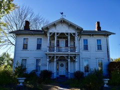 | Burkholder-O'Keefe House | 0.4 miles | 1989 |
| National Archives record | The nomination case file for reference 100007420 in Record Group 79. |
| Randolph County | All 5 listed properties in this county. |