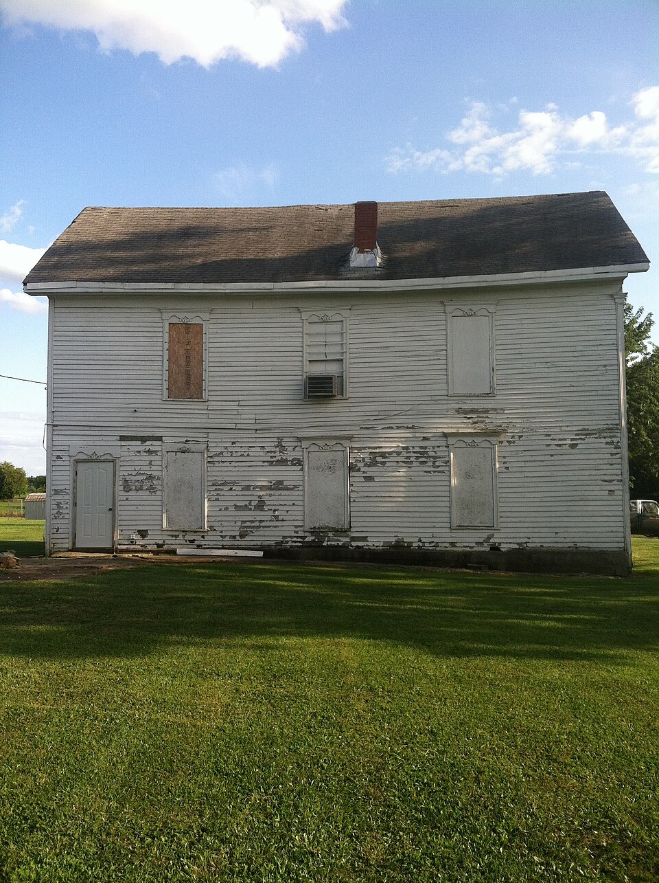
Harrisburg School-Ancient Landmark Masonic Lodge Number 356 A.F. & A.M.
Listed on the National Register of Historic Places in 2013.
From the record
“The Ancient Landmark Masonic Lodge Number 356 A.F. and A.M. is located in Harrisburg, Missouri and played a major role in the social and educational history of the town. The building was listed on the National Register of Historic Places in 2013 and houses the Order of the Eastern Star.”
Wikipedia article Harrisburg School, CC BY-SA 4.0.
One of 51 National Register listings published here for Boone County · listed in 2013 · category: Building.
^ About the Ist of September, 1864, a man uatned Drake, who had recently come into the township from Sullivan county, was shot from the bush as he was passing along the road. Eight buckshot entered hfs body. The bushwhackers who did the deed gave information at a house near by that the dead body might be cared for.
The chapter on Perche Township in History of Boone County, Missouri, published 1882 names Harrisburg. This is what it says, exactly as the scans read.
Harrisburg, situated on the northwest quarter of section 11, township 50, range 14, in the northwest corner of the township, was named in honor of John W. Harris, deceased, late proprietor of the Model Farm. It was laid off soon after the survey of the Chicago and Alton railroad, and gave promise of soon becoming a town of considerable importance. Work was actively going on all along the line of the proposed railroad, which was actually graded and made ready for the mils. The town prospered in anticipation of the early completion of the road ; but, to the surprise and disappointment of the people of Harrisburg and Perche township, the road was suddenly abandoned^ but afterwards completed on a line farther north. This proved almost a death-blow to the ambitious hopes of Harrisburg. With better facilities this village would have been a place of no little importance. It is beautifully located on the divide between the Perche and the Moniteau, six miles north of the Model Farm, on the main road leading from Eocheport to Sturgeon. The Callaham, which flows into tie Perche, heads in this vicinity. Prairie Fork, named from Thrairs prairie, also heads in this vicinity, and flows west into the Moniteau. Harrisburg contains three stores, a confectionery shop, church, mill, blacksmith and repair shop, a fine public school building, with Masonic hall above. Dr. Haller, a practicing physician, Hersman, a justice of the peace, and S. O. Puller, constable, reside in the village. The post-oflSce is in Gentry's saddler-shop. Rev. Green Carey, of rfear Harrisburg, came to the neighborhood in 1834, and had preached for the i^eople since 1836. He was a member of the first church organized in this portion of the county, Bethlehem by name, which he served for thirty-one years. He has joined in marriage more than five hundred couples. Revs. Thomas Fristoe, Fielding Wilhite and Green <Jarey dedicated the last Bethlehem church building.
The Blakemores are of English origin. From England to Virginia, from Virginia to Kentucky, and thence westward. William Edward Blakemore is a grandson of James Blakemore, of Virginia, and a son of Wm. G. Blakemore, also a native of that State. He was born in Clark county, Kentucky, March 12th, 1837. He lived on the farm until he was sixteen years old, then entered a store, remaining in this business for six years. Quitting the store at the age of twenty-two, he embarked in the live stock trade which he followed for nine years. In 1853 he again entered the mercantile business, but once more abandoned the store to engage in the stock trade, this time dealing in mules and horses for the Southern market. He came to Missouri in November, 1865, and settled on the '*oldWiggam farm," in the vicinity of Harrisburg, where he remained till 1875. In 1880 he came to Harrisburg and engaged in the mercantile business with John W. Hersman. Mr. Blakemore was married to Miss Nancy J. Doyle, daughter of Dennis Doyle. By this marriage they have had eight children, six sons and two daughters, one of whom died in infancy. Their names are: Mary V., George W., Dennis A., Richard E., Sarah E., Claudius P., Thomas C, and Shelton L. They are members of the Christian Church at Harrisburg.
Regional context, not property-specific
evidence. The federal mineral resources record lists
2 workings within 5 miles of Harrisburg School-Ancient Landmark Masonic Lodge Number 356 A.F. & A.M.: 2 past producers.
None of them still produces. What was taken out: Stone, Crushed/Broken. Distance is straight-line from the
map coordinates, so a quarry counted here may appear on a neighbouring
settlement's page as well.
Regional context, not property-specific
evidence. The National Weather Service names
Harrisburg, the town this property stands in, in 31 storm reports between 1993 and 2023: 19 hail, 7 thunderstorm wind, 3 flash flood, 1 tornado.
No death or injury is recorded in these reports. Each account below is quoted exactly as the forecast office
filed it, from the NOAA Storm Events Database, and each date
opens the federal record of that event.
Widespread wind damage occurred across Boone County. One large tree was blown down at the intersection of Highway F and Stidham Road. A large tree was blown over onto Old U.S. Highway 63 near Dripping Springs Road. Several trees were blown down across Old Plank Road near the intersection with Route K. Also, several power lines were blown down at Providence Road and Wilkes Boulevard and a street light was snapped off falling onto the intersection of 7th Street and Cherry Street. More trees were blown down near the intersection of Highway WW and S. Rangeline Road.
Thunderstorm winds blew down a large tree onto N. Barnett School Road. Also, another large tree was blown down near the intersection of N. Ogden Street and E. Stone Street in Sturgeon.
Even though the rain had tapered off, flooding continued to affect the southern half of Boone County. Numerous federal, state and local roads remained flooded. Also, a number of creeks were well out of their banks including Hinkson Creek, Perche Creek, Harmony Creek and Bear Creek.
Widespread flash flooding was reported across the southern half of Boone County, when up to 7 inches of rain fell in a span of 6 hours. Several water rescues were reported, including one swift water rescue. Columbia firefighters rescued a man who was clinging to a tree in Bear Creek downstream of North Creasy Springs Road after his car got swept away by the swift current. They also rescued two people from a mobile home on North Hinkson Creek Road. At least an additional 10 water rescues were performed after the drivers drove into flood waters in a number of locations around the county. Numerous roads were flooded including U.S. Highway 63 at intersection with Highway 163, Nifong Boulevard at Glen Eagle Drive, Highway WW at Old Hawthorne, Creasy Springs and Bear Creek, North Route V at Barnes School Road, and U.S. Highway 40 near Midway. The rain pushed Hinkson Creek to a record high level, flooding Wilsons Total Fitness and the Missouri Athletic Center at Forum Boulevard and closing Providence Road through midday on Friday. A section of West Dripping Springs Road was washed out due to flash flooding from Silver Fork Creek. Highway E was flooded where it crosses over Perche Creek and Route ZZ was flooded by Harmony Creek. Also, Route Y east of Ashland was closed due to flooding from Cedar Creek. No deaths or injuries were reported.
Widespread wind damage across the northern portions of Boone County. Numerous trees, tree limbs and power lines were blown down in Harrisburg, Sturgeon, Hallsville and Centralia. Two miles west of Hallsville, one residence had a section of its roof torn off and a mile south of Sturgeon a barn was destroyed and pushed onto a nearby road.
Up to 7 inches of rain fell over two days in Boone County causing flash flooding. Numerous roads were flooded including U.S. Highway 40 near W. Cunningham Drive, Gillespie Bridge Road near Coats Lane, Strawn Road near Broadway, Brown School Road, and Twin Bridges on Route E.
Between 2 and 3 inches of rain fell in a short amount of time causing flash flooding. Several roads were impassable or closed including McKee Road at Orchard Lane, Broadway at Old Hawthorne Road and Rangeline Road at the intersection with Highway AB.
County officials reported wind gusts as high as 70 mph between Harrisburg and Columbia but no damage to trees. Wind gusts were also reported as high as 70 mph just west of Columbia along with dime-size hail by SKYWARN spotters.
No historic map-sheet match is published
for this property yet. That does not mean no map exists. This record needs
a coordinate-quality review before it can be joined to a sheet boundary.
Browse the county's mapped places while that work is
pending.
Listing record. National Park Service National Register of Historic Places, listed-properties dataset, current to 2026-05-22.
Map join. Address geocoded through the United States Census geocoder, then tested against the published boundary of every sheet in the USGS Historical Topographic Map Collection.
How this page is made. Listing fields come from federal records; map-sheet coverage is a labelled coordinate-to-boundary calculation, not a source-field claim.
Mines and quarries. USGS Mineral Resources Data System (MRDS) https://mrdata.usgs.gov/mrds/ A work of the United States government, no copyright under 17 U.S.C. 105.
Storms. NOAA National Centers for Environmental Information, Storm Events Database https://www.ncei.noaa.gov/stormevents/ A work of the United States government, no copyright under 17 U.S.C. 105. Narratives are quoted verbatim from the National Weather Service report and are not edited or summarised.
 Block