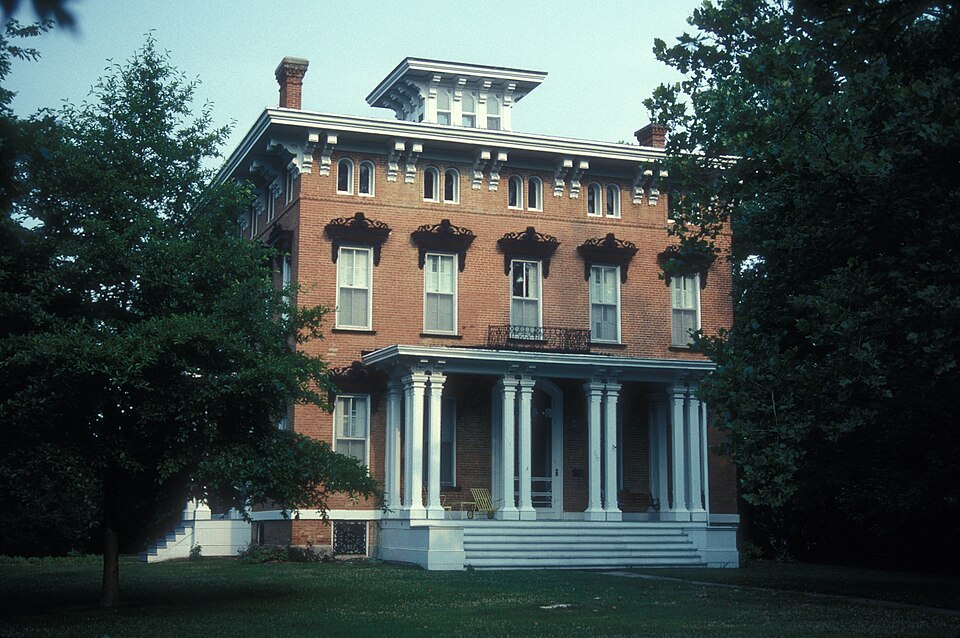
Listed on the National Register of Historic Places in 1972.
From the record
“Benjamin House, also known as the Benjamin House and Vesper Place, is a historic home located at Shelbina, Shelby County, Missouri. It was built in 1872-1873, and is a three-story, Italian Villa brick dwelling over a full basement.”
Wikipedia article Benjamin House (Shelbina, Missouri), CC BY-SA 4.0.
One of 4 National Register listings published here for Shelby County · listed in 1972 · category: Building.
National Register reference number.72000732- the number the National Park Service assigned this property when it was listed, and the key its nomination file is catalogued under at the National Archives.
Fires near this property
17 since 2002
Regional context, not property-specific
evidence. The
federal wildfire occurrence database
lists 17 fires within 5 miles of Benjamin House
between 2002 and 2020, burning about 81 acres in total. None started naturally. None was recorded as arson.
Distance is straight-line from the map coordinates, so a fire counted
here may appear on a neighbouring settlement's page as well.
Reported cause
Fires
Debris and open burning
10
Other causes
2
Missing data/not specified/undetermined
2
Equipment and vehicle use
2
Recreation and ceremony
1
The most recent of
them, most recent first, with the day each was reported and the service
that recorded it.
Regional context, not property-specific
evidence. The federal mineral resources record lists
3 workings within 5 miles of Benjamin House: 3 past producers.
None of them still produces. What was taken out: Stone, Crushed/Broken. Distance is straight-line from the
map coordinates, so a quarry counted here may appear on a neighbouring
settlement's page as well.
Regional context, not property-specific
evidence. The National Weather Service names
Shelbina, the town this property stands in, in 31 storm reports between 1999 and 2024: 16 thunderstorm wind, 10 hail, 4 tornado, 1 flash flood.
No death or injury is recorded in these reports. Each account below is quoted exactly as the forecast office
filed it, from the NOAA Storm Events Database, and each date
opens the federal record of that event.
A large tree snapped near its base on Highway 15 near Shelbina Lake. Another tree fell behind Ayerco. Power was reportedly out in Shelbina and Hunnewell.
Thunderstorm winds caused damage to a farmstead on the north side of Highway WW near intersection with County Road 425, southwest of Shelbina. The barn roof was torn off and an empty semi trailer was blown over onto a pickup truck. The barn door was also torn off and thrown a quarter of a mile south (into Monroe County). In Shelbina, several large trees and numerous tree limbs were blown down around town. One large tree landed on a house causing major damage. A large tree limb fell onto a pickup truck causing damage.
A brief tornado was observed touching down in a field southwest of Shelbina. The tornado was on the ground less than a minute and did no damage. The tornado was rated EFU with a path length of approximately 0.10 miles and a path width of 10 yards. No damage was reported.
The first tornado formed near Elm Street and Douglas Avenue, north of U.S. Highway 36 at approximately 1245 a.m. CDT. The roof and walls of a corrugated steel building buckled on the west and south sides, along with a portion of the roof. The tornado moved across U.S. Highway 36 and destroyed three unoccupied house trailers. Debris was tossed about 100 yards from the trailers. The tornado continued to move east-southeast and caused roof damage to the town power and water plants on Chestnut Street west of Shelby Street. A portion of the gables holding the roof of the power plant was uplifted and tossed approximately 50 yards to the east. Much of the water plant's roof was removed and tossed 40 to 50 yard to the east. The tornado then caused minor roof damage on homes and snapped numerous large trees about 10 to 20 feet from the base. Some of the large branches fell on top of vehicles. The tornado then caused extensive damage to the roof of the two story town museum on Center Street (Highway 15). Several bricks fell to the ground from the top of the museum roof. Additional tree damage was found east and southeast of the town museum building. The path length was 1.15 miles with width varying between 50 and 70 yards. The tornado was rated an EF1.
The second tornadic damage track was just to the south of the first tornado. It began west of South Center Street, where significant tree damage occurred. Some of the trees fell on top of homes. The tornado traveled east-southeast and hit an assisted living home on Shelbina Avenue. Roof damage was found at this location. Other large trees were damaged in the vicinity of the assisted living home. The tornado continued to the east-southeast and destroyed a large machine shed built in 2008. The east, south and west sides and the roof of the machine shed were tossed into several corn fields. The tornado then crossed County Road 441, where it hit a tree line with several trees snapped 15 to 20 feet from the base and tree trunk diameters ranging from 1 to 2.5 feet. The width of the damage in this area was 50 yards. The path length was 1.22 miles with a max width of 70 yards. The tornado was rated an EF1.
The tornado initially touched down 1.5 miles south of Shelbina just west of Highway 15, damaging a small storage building and scattering debris across Highway 15. The tornado then continued to the east-northeast, severely damaging a large metal farm building. The debris from this building was blown downwind over half a mile. The maximum damage was rated EF1, with a maximum wind speed around 90 mph. Total length of this tornado was around a mile, with a maximum width of 20 to 30 yards.
In addition to the tornadoes in the area, damaging straight line winds occurred throughout the area, primarily on an axis from 3 miles southwest of Shelbina to 3 miles east of Shelbina. The strongest straight line winds, approaching 90 mph, appear to have occurred east of Shelbina and just south of U.S. Highway 36, where power poles were snapped off by the high winds. Just north of U.S. Highway 36, the west side of a large machine shed also suffered significant straight line wind damage.
Fifteen to twenty power poles were blown down along the Shelby/Monroe county line. Also, several trees were blown down along Highway 15 on the north side of Shelbina.
Up to 4 inches of rain fell over a three hour period over the southern half of Shelby county. Numerous roads were flooded including U.S. 36. Highway 36 was closed for a time from about 5 miles east of Shelbina to Lakenan. Up to 3 feet of water was flowing over the road at several locations. A number of cars attempted to cross the flooded roadways and became stalled. One car was completely swept off the road after the driver had been rescued from his stalled car, so no one was in the vehicle when it was swept off the road. In Shelbina, several homes sustained water damage in their basements due to sewer backups.
No historic map-sheet match is published
for this property yet. That does not mean no map exists. This record needs
a coordinate-quality review before it can be joined to a sheet boundary.
Browse the county's mapped places while that work is
pending.
Listing record. National Park Service National Register of Historic Places, listed-properties dataset, current to 2026-05-22.
Map join. Address geocoded through the United States Census geocoder, then tested against the published boundary of every sheet in the USGS Historical Topographic Map Collection.
How this page is made. Listing fields come from federal records; map-sheet coverage is a labelled coordinate-to-boundary calculation, not a source-field claim.
Wildfire. Short, Karen C. 2022. Spatial wildfire occurrence data for the United States, 1992-2020 [FPA_FOD_20221014]. 6th Edition. Fort Collins, CO: Forest Service Research Data Archive. https://doi.org/10.2737/RDS-2013-0009.6 Collected with United States Government funding and usable without additional permissions or fees.
Mines and quarries. USGS Mineral Resources Data System (MRDS) https://mrdata.usgs.gov/mrds/ A work of the United States government, no copyright under 17 U.S.C. 105.
Storms. NOAA National Centers for Environmental Information, Storm Events Database https://www.ncei.noaa.gov/stormevents/ A work of the United States government, no copyright under 17 U.S.C. 105. Narratives are quoted verbatim from the National Weather Service report and are not edited or summarised.
 Block