
BlockBefore
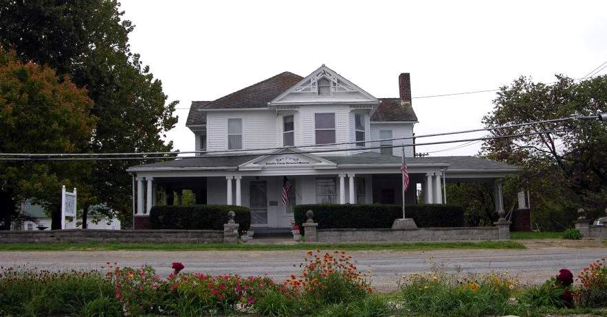
Photograph of William P. Hall House
Photograph by Sector001, CC BY-SA 3.0. Via Wikimedia Commons.

Hall, William P., House

Listed on the National Register of Historic Places in 1975.

From the record

“Hall House is a historic home located at Lancaster, Schuyler County, Missouri, United States. It was built about 1902, and is a large two-story, irregular plan, Late Victorian style frame dwelling.”

Wikipedia article William P. Hall House, CC BY-SA 4.0.

One of 2 National Register listings published here for Schuyler County · listed in 1975 · category: Building.

Sources: the Wikipedia article · the case file at the National Archives · the National Register database, National Park Service

The listing

  • What is counted as historic. The nomination lists 1 building as contributing to the listing.
  • Address. U.S. 136, W of Schuyler County Courthouse, Lancaster, 63548
  • When was it listed? April 1975
  • Category. building
  • Township. Liberty township
  • National Register reference number. 75001073 - the number the National Park Service assigned this property when it was listed, and the key its nomination file is catalogued under at the National Archives.

Fires near this property

11 since 2002

Regional context, not property-specific evidence. The federal wildfire occurrence database lists 11 fires within 5 miles of Hall, William P., House between 2002 and 2015, burning about 203 acres in total. None started naturally. None was recorded as arson. Distance is straight-line from the map coordinates, so a fire counted here may appear on a neighbouring settlement's page as well.

Reported cause Fires
Debris and open burning8
Missing data/not specified/undetermined2
Smoking1

The most recent of them, most recent first, with the day each was reported and the service that recorded it.

DateCause SizeReported by Name on the report
4 July 2014Missing data/not specified/undetermined1.0 acresMissouri Department of Conservationnot named
3 May 2014Smoking1.0 acresMissouri Department of Conservationnot named
19 May 2014Debris and open burning1.0 acresMissouri Department of Conservationnot named
16 May 2014Debris and open burning4.0 acresMissouri Department of Conservationnot named
12 April 2014Debris and open burning2.0 acresMissouri Department of Conservationnot named
10 April 2014Debris and open burning15 acresMissouri Department of Conservationnot named
20 March 2002Debris and open burning35 acresMissouri Department of Conservationnot named
16 March 2015Debris and open burning1.0 acresMissouri Department of Conservation121876-09828-03162015-1250

Every fire recorded in Schuyler County

Storms near this property

28 since 1993

Regional context, not property-specific evidence. The National Weather Service names Lancaster, the town this property stands in, in 28 storm reports between 1993 and 2024: 13 hail, 9 thunderstorm wind, 5 flash flood, 1 tornado. The reports record 1 death. Each account below is quoted exactly as the forecast office filed it, from the NOAA Storm Events Database, and each date opens the federal record of that event.

WhenEvent Place namedHarm What the report says
May 2010Flash FloodLancaster1 killedFlash flooding caused pavement over a culvert to give way. This caused the front end of a vehicle, to fall through the roadway. While attempting to get out of the vehicle, a 32 year old male, was swept away by the current and drowned.
April 1994Thunderstorm WindLancaster$50,000The county sheriff reported wind damage to the roof of a house.
April 1993Thunderstorm WindLancaster$50,000The county sheriff reported two damaged garages in Glenwood. A television weatherman from KTVO in Kirksville reported several signs blown down and a mobile home flipped over at Lancaster. Time was estimated.
July 2006Tornado (F1)Lancaster$15,000Tornado touched down along D highway 1.75 miles south-southeast of Lancaster at 1935 CST. A damage path was noted for 1.1 miles, and the storm damaged 3 farmsteads directly. The first farmstead had an outbuilding destroyed and windows blown out of the farmhouse. As the tornado moved south, two barns were destroyed at the second farmstead. Near Gray's Drive and Highway D, just southwest of the D and V Highway intersection, additional damage was noted to a third farmstead, with significant low-end F1 damage to outbuildings. Numerous trees and power lines were also downed along Highway D. Anecdotal observations suggest the tornado turned left before dissipating at 1938 CST, and then may have looped back north along Highway D to near the Highways D and V intersection, where minor damage was noted to a fourth homestead.
June 2008Thunderstorm WindLancaster$10,000Damage to building and sheds blown over along Highway 63.
August 2006Thunderstorm WindLancaster$1,000Machine shed had roof torn partially off. Tree damage around Highway V.
June 2024Thunderstorm WindLancaster-Multiple large tree limbs downed and 5 power poles downed or damaged in Lancaster.
June 2024Thunderstorm WindLancaster-Volunteer fire fighter records a 60 mph measured gust on a personal weather station.
July 2015Flash FloodLancaster-Water was over Highway 136 east of Highway 63.
July 2015Flash FloodLancaster-Water was over Highway 136 east of Lancaster.
May 2013Thunderstorm WindLancaster-Widespread tree damage was reported. A tractor trailer was blown over. Thunderstorm wind gusts were estimated up to 60 mph.
July 2008Flash FloodLancaster-Routes U and M were closed due to high water.
June 2008Flash FloodLancaster-Several county roads were flooded.
June 2000Thunderstorm WindLancaster-Corn was flattened, and trim was torn off a house.
May 1997HailLancaster-The Schuyler County Sherrif's office reported golfball-size hail a mile southeast of Lancaster and dime-size hail 2 miles northwest of Downing.
August 2019HailLancaster-no account filed
June 2015HailLancaster-no account filed
April 2011HailLancaster-no account filed
June 2011HailLancaster-no account filed
March 2007HailLancaster-no account filed
August 2007Thunderstorm WindLancaster-no account filed
July 2006HailLancaster-no account filed
January 2005HailLancaster-no account filed
June 2005HailLancaster-no account filed
April 2003HailLancaster-no account filed
April 2002HailLancaster-no account filed
April 2000HailLancaster-no account filed

Every storm recorded in Schuyler County

Map coverage status

No historic map-sheet match is published for this property yet. That does not mean no map exists. This record needs a coordinate-quality review before it can be joined to a sheet boundary. Browse the county's mapped places while that work is pending.

Sources for this property

National Archives recordThe nomination case file for reference 75001073 in Record Group 79.
Wikipedia articleCommunity-written account of this property, licensed CC BY-SA.
Schuyler CountyAll 2 listed properties in this county.

Provenance

  • Listing record. National Park Service National Register of Historic Places, listed-properties dataset, current to 2026-05-22.
  • Map join. Address geocoded through the United States Census geocoder, then tested against the published boundary of every sheet in the USGS Historical Topographic Map Collection.
  • How this page is made. Listing fields come from federal records; map-sheet coverage is a labelled coordinate-to-boundary calculation, not a source-field claim.
  • Wildfire. Short, Karen C. 2022. Spatial wildfire occurrence data for the United States, 1992-2020 [FPA_FOD_20221014]. 6th Edition. Fort Collins, CO: Forest Service Research Data Archive. https://doi.org/10.2737/RDS-2013-0009.6 Collected with United States Government funding and usable without additional permissions or fees.
  • Storms. NOAA National Centers for Environmental Information, Storm Events Database https://www.ncei.noaa.gov/stormevents/ A work of the United States government, no copyright under 17 U.S.C. 105. Narratives are quoted verbatim from the National Weather Service report and are not edited or summarised.