 Block
From the record
One of 4 National Register listings published here for Holt County · listed in 1978 · category: Building.
Sources: the case file at the National Archives · the National Register database, National Park Service · the Wikipedia article
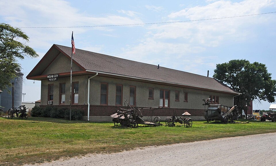
Listed on the National Register of Historic Places in 1978.
One of 4 National Register listings published here for Holt County · listed in 1978 · category: Building.
Sources: the case file at the National Archives · the National Register database, National Park Service · the Wikipedia article
The chapter on Benton Township in History of Holt County, Missouri : from the Time of the Platte Purchase to the End of the Year 1916 : Preceded by a Short History of Missouri : Supplemented by Biographical Sketches of Prominent Citizens, published 1917 names Mound City. This is what it says, exactly as the scans read.
Among other early settlers of the township were Jacob Mosher, who came in 1842, and died thirty years after. Andrew McCoy, from Ohio, and Washam came in 1848. Andrew Meyer, long a representative citizen of the township, came in 1843. William Gady, in the same year, made a claim adjoining the site of Mound City, but subsequently abandoned it. Henry Swimiller came in 1846.
Passage source: History of Holt County, Missouri : from the Time of the Platte Purchase to the End of the Year 1916 : Preceded by a Short History of Missouri : Supplemented by Biographical Sketches of Prominent Citizens, published 1917.
Among the noted settlers of Benton Township, was Levi Dodge, for many years a prominent citizen of the town of Mound City. Mr. Dodge, who was a native of the State of Maine, moved thence to Ohio, in an early day, thence to Clinton County, Missouri. When he came to Holt County he settled on section 26, township 62, range 39, a farm later owned by John Shrantz.
Passage source: History of Holt County, Missouri : from the Time of the Platte Purchase to the End of the Year 1916 : Preceded by a Short History of Missouri : Supplemented by Biographical Sketches of Prominent Citizens, published 1917.
Machine-read from a century-old scan, so expect the errors a machine makes: misspelled names, dropped words, stray characters.
Read the whole chapter on Benton Township - 8,290 words on its settlement, mills, schools and churches.
Regional context, not property-specific evidence. The federal wildfire occurrence database lists 22 fires within 5 miles of Chicago, Burlington and Quincy Depot between 1995 and 2018, burning about 1,656 acres in total. 1 started naturally. 4 were recorded as arson. Distance is straight-line from the map coordinates, so a fire counted here may appear on a neighbouring settlement's page as well.
| Reported cause | Fires |
|---|---|
| Debris and open burning | 8 |
| Missing data/not specified/undetermined | 5 |
| Arson/incendiarism | 4 |
| Smoking | 3 |
| Railroad operations and maintenance | 1 |
| Natural | 1 |
The most recent of them, most recent first, with the day each was reported and the service that recorded it.
| Date | Cause | Size | Reported by | Name on the report |
|---|---|---|---|---|
| 13 August 2006 | Natural | 76 acres | Squaw Creek National Wildlife Refuge | NORTH WET MEADOW FIRE |
| 19 June 2012 | Missing data/not specified/undetermined | under an acre | Squaw Creek National Wildlife Refuge | RODEO GROUNDS |
| 7 April 2014 | Missing data/not specified/undetermined | 46 acres | Squaw Creek National Wildlife Refuge | BIGELOW |
| 28 April 2004 | Smoking | under an acre | Squaw Creek National Wildlife Refuge | NORTH WOODS TOUR ROUTE |
| 2 April 2011 | Missing data/not specified/undetermined | 2.0 acres | Squaw Creek National Wildlife Refuge | WILSON |
| 15 April 2006 | Missing data/not specified/undetermined | 1.0 acres | Squaw Creek National Wildlife Refuge | PENDIGON CLUB |
| 12 April 2014 | Missing data/not specified/undetermined | 8.0 acres | Squaw Creek National Wildlife Refuge | LEACH |
| 12 April 2000 | Smoking | 1.0 acres | Squaw Creek National Wildlife Refuge | THREAT |
Regional context, not property-specific evidence. The National Weather Service names Mound City, the town this property stands in, in 49 storm reports between 1993 and 2024: 23 hail, 18 thunderstorm wind, 6 flash flood, 1 flood. No death or injury is recorded in these reports. Each account below is quoted exactly as the forecast office filed it, from the NOAA Storm Events Database, and each date opens the federal record of that event.
| When | Event | Place named | Harm | What the report says |
|---|---|---|---|---|
| July 1997 | Thunderstorm Wind | Mound City | $250,000 | Mound City Police reported 2 semi-tractor trailers blown off the road just off an Interstate 29 exit. The were also several reports of large trees and power lines blown over and the roof torn off a shed in Mound City. Mound City police estimated the damage path to be a mile wide through town. |
| June 1994 | Hail | Mound City | $50,000 | Golf ball-size hail broke windows, damaged roofs, and dented automobiles in Mound City, Fortesque, and Big Lake. Hail damage to crops nearly $500,000 alone. |
| August 2015 | Thunderstorm Wind | Mound City | $10,000 | Several power lines were reported down in Mound City as a result of strong winds. |
| July 1995 | Thunderstorm Wind | Mound City | $4,000 | Severe thunderstorm winds blew down trees and a grain trailer. |
| June 1995 | Thunderstorm Wind | Mound City | $3,000 | Severe thunderstorms produced wind gusts to 65 mph north of Mound City, knocking down trees. In Mound City trees fell on power and telephone poles, interrupting service. |
| March 2006 | Thunderstorm Wind | Mound City | $2,000 | Power lines and trees down. Sheds damaged. |
| June 1995 | Thunderstorm Wind | Mound City | $2,000 | Severe thunderstorms produced wind gusts to 65 mph north of Mound City, knocking down trees. In Mound City trees fell on power and telephone poles, interrupting service. |
| June 2024 | Thunderstorm Wind | Mound City | - | Estimated gusts up to 60 mph in Mound City. |
| April 2023 | Hail | Mound City | - | Quarter sized hail fell in Mound City. |
| July 2023 | Thunderstorm Wind | Mound City | - | Estimated 60 mph wind gusts in Mound City. |
| June 2022 | Thunderstorm Wind | Mound City | - | Dispatch reported a large tree down in Mound City. |
| August 2021 | Thunderstorm Wind | Mound City | - | A large tree was down in Mound City, which caused a street to be closed. |
| June 2019 | Tornado (EF0) | Mound City | - | After a report of a tornado was received by the office investigation using online news and inquiries to local business helped identify the path of this brief and weak tornado through portions of Mound City. Little to no damage occurred outside of several tree limbs and light objects. |
| March 2017 | Thunderstorm Wind | Mound City | - | Sheriff deputy in Mound City reported power lines down. |
| March 2017 | Thunderstorm Wind | Mound City | - | Tractor trailer rig overturned on I-29 near Mound City from thunderstorm winds. |
| July 2016 | Thunderstorm Wind | Mound City | - | A tree was reported down in Mound City. The size and condition of the tree is unknown. |
| August 2015 | Flash Flood | Mound City | - | There was 6 inches of water running over Highway 59 near Davis Creek. |
| August 2015 | Flash Flood | Mound City | - | Local sheriff estimated 8 inches of water over Route E and US Highway 59. |
| June 2015 | Flash Flood | Mound City | - | Route N was closed in both directions due to flooding. Interstate 29 also was briefly closed in Holt County due to flooding. |
| June 2015 | Flood | Mound City | - | North and south bound lanes of interstate 29 were closed near Highway 59 due to flooding from Squaw Creek. |
| September 2014 | Flash Flood | Mound City | - | Interstate 29 between mile marker 86 and 88 had water running over it from Squaw Creek. |
| September 2013 | Thunderstorm Wind | Mound City | - | A tree was reported down with thunderstorm wind gusts estimated up to 60 mph. |
| August 2009 | Thunderstorm Wind | Mound City | - | A two to three foot in diameter tree, was blown down in town. |
| August 2007 | Thunderstorm Wind | Mound City | - | Six inch tree limbs covering Highway 59. |
| May 2004 | Flash Flood | Mound City | - | Heavy rains have caused water covered roads. |
| June 2004 | Thunderstorm Wind | Mound City | - | Trees reported down. |
| June 1997 | Flash Flood | Mound City | - | Water covered roadways a mile north of Mound City. The Holt County Sheriff's office reported that mud had to be cleared from the several roads. One to two inches of rain fell during the thunderstorms that caused the flooding. |
| March 2020 | Hail | Mound City | - | no account filed |
| March 2020 | Hail | Mound City | - | no account filed |
| April 2016 | Hail | Mound City | - | no account filed |
| May 2016 | Hail | Mound City | - | no account filed |
| May 2016 | Hail | Mound City | - | no account filed |
| April 2013 | Hail | Mound City | - | no account filed |
| March 2009 | Hail | Mound City | - | no account filed |
| June 2009 | Hail | Mound City | - | no account filed |
| June 2008 | Hail | Mound City | - | no account filed |
| May 2006 | Hail | Mound City | - | no account filed |
| May 2005 | Hail | Mound City | - | no account filed |
| June 2005 | Hail | Mound City | - | no account filed |
| May 2004 | Hail | Mound City | - | no account filed |
| May 2004 | Hail | Mound City | - | no account filed |
| August 2004 | Hail | Mound City | - | no account filed |
| May 2002 | Thunderstorm Wind | Mound City | - | no account filed |
| May 2002 | Hail | Mound City | - | no account filed |
| June 2002 | Hail | Mound City | - | no account filed |
| May 2001 | Hail | Mound City | - | no account filed |
| February 2000 | Hail | Mound City | - | no account filed |
| May 1995 | Hail | Mound City | - | no account filed |
| September 1993 | Hail | Mound City | - | no account filed |
No historic map-sheet match is published for this property yet. That does not mean no map exists. This record needs a coordinate-quality review before it can be joined to a sheet boundary. Browse the county's mapped places while that work is pending.
| National Archives record | The nomination case file for reference 78001648 in Record Group 79. |
| Wikipedia article | Community-written account of this property, licensed CC BY-SA. |
| Holt County | All 4 listed properties in this county. |