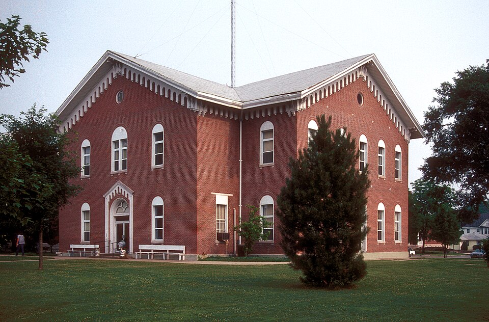
Listed on the National Register of Historic Places in 1978.
From the record
“The Macon County Courthouse and Annex is a historic courthouse and annex located at Courthouse Sq. in Macon, Macon County, Missouri. It was built in 1865, and is a two-story, cross-plan, Romanesque Revival style brick building with Italianate style detailing.”
Wikipedia article Macon County Courthouse and Annex, CC BY-SA 4.0.
One of 9 National Register listings published here for Macon County · listed in 1978 · category: Building.
National Register reference number.78001668- the number the National Park Service assigned this property when it was listed, and the key its nomination file is catalogued under at the National Archives.
Fires near this property
25 since 1992
Regional context, not property-specific
evidence. The
federal wildfire occurrence database
lists 25 fires within 5 miles of Macon County Courthouse and Annex
between 1992 and 2020, burning about 203 acres in total. None started naturally. None was recorded as arson.
Distance is straight-line from the map coordinates, so a fire counted
here may appear on a neighbouring settlement's page as well.
Reported cause
Fires
Debris and open burning
11
Missing data/not specified/undetermined
10
Equipment and vehicle use
3
Smoking
1
The most recent of
them, most recent first, with the day each was reported and the service
that recorded it.
Regional context, not property-specific
evidence. The National Weather Service names
Macon, the town this property stands in, in 37 storm reports between 1994 and 2024: 18 hail, 12 thunderstorm wind, 6 flash flood, 1 flood.
No death or injury is recorded in these reports. Each account below is quoted exactly as the forecast office
filed it, from the NOAA Storm Events Database, and each date
opens the federal record of that event.
Thunderstorm winds gusted to 63 mph (55 knots) at the Macon Airport. Significant damage occurred to two hangars with roofs blown off and walls blown down. Large hail also occurred.
Heavy rainfall continued through daybreak resulting in continued flooding of numerous roadways across Macon County, including Highway 63. The Macon County Sheriff's office reported a total of 5 road closures as a result of the flooding, including Highway 165 west of La Platta. All roads were reopened after 8 AM.
Rainfall amounts of 2 to 4 inches over sections of Macon County resulted in significant road flooding especially along Highway 63 which was closed between 1:23 AM and 2:29 AM CST. Highway 63 was closed from Macon northward to the Adair County line.
Severe thunderstorms moved through the county, causing significant wind damage. Several trees were downed in the Ethel area, with more widespread damage around Macon. Wind gusts to 60 mph were recorded at the Macon airport, with several reports of downed trees in and around the city. Trees partially blocked PP highway southeast of town. A barn was damaged at the fairgrounds, and a grain bin was blown over onto the street. Damage was done to the screen at the drive-in theater, as well as to the marquis and surrounding fences. Five power poles were downed, and a roof was blown off of a building at the Heartland Building Supply.
Severe thunderstorms moved through the county, causing significant wind damage. Several trees were downed in the Ethel area, with more widespread damage around Macon. Wind gusts to 60 mph were recorded at the Macon airport, with several reports of downed trees in and around the city. Trees partially blocked PP highway southeast of town. A barn was damaged at the fairgrounds, and a grain bin was blown over onto the street. Damage was done to the screen at the drive-in theater, as well as to the marquis and surrounding fences. Five power poles were downed, and a roof was blown off of a building at the Heartland Building Supply.
No historic map-sheet match is published
for this property yet. That does not mean no map exists. This record needs
a coordinate-quality review before it can be joined to a sheet boundary.
Browse the county's mapped places while that work is
pending.
Listed places nearby
2 within 8 miles
Other National Register properties close
enough to walk or drive between, ordered by distance from this one. Both
positions come from the same geocoding pass that matched these properties
to their map sheets.
Listing record. National Park Service National Register of Historic Places, listed-properties dataset, current to 2026-05-22.
Map join. Address geocoded through the United States Census geocoder, then tested against the published boundary of every sheet in the USGS Historical Topographic Map Collection.
How this page is made. Listing fields come from federal records; map-sheet coverage is a labelled coordinate-to-boundary calculation, not a source-field claim.
Wildfire. Short, Karen C. 2022. Spatial wildfire occurrence data for the United States, 1992-2020 [FPA_FOD_20221014]. 6th Edition. Fort Collins, CO: Forest Service Research Data Archive. https://doi.org/10.2737/RDS-2013-0009.6 Collected with United States Government funding and usable without additional permissions or fees.
Storms. NOAA National Centers for Environmental Information, Storm Events Database https://www.ncei.noaa.gov/stormevents/ A work of the United States government, no copyright under 17 U.S.C. 105. Narratives are quoted verbatim from the National Weather Service report and are not edited or summarised.
 Block