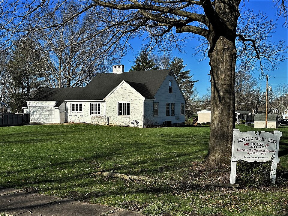
Listed on the National Register of Historic Places in 1990.
From the record
“Lester and Norma Dent House, also known as the House of Gadgets, is a historic home located at La Plata, Macon County, Missouri. It was built in 1941, and is a one-and-a-half-story, Modern Movement style dwelling sheathed in brick and asbestos siding.”
Wikipedia article Lester and Norma Dent House, CC BY-SA 4.0.
One of 9 National Register listings published here for Macon County · listed in 1990 · category: Building.
National Register reference number.90000763- the number the National Park Service assigned this property when it was listed, and the key its nomination file is catalogued under at the National Archives.
The ground it stands on
4,031 words
The chapter on La Plata Township in Hand-book of Macon County, Missouri .., published 1888 names La Plata. This is what it says, exactly as the scans read.
It is located in the north end of Macon county, on the crown of the "Great Divide," in the midst of a royal farm region capable of sustaining a city of .5,000 souls, and is one of the most prosperous and enterprising towns of its class in Missouri. This go-ahead little city has 1,100 wide-awake and progressive people, and other that will be of interest to the reader, among which are a healthy and commanding location, an ample supply of pure water, plenty of neighboring coal and timber, six churches, a full representation of the leading fraternities, a post of the Grand Army, a live newspaper, a successful creamery, an elegant public school house and superior schools, about twenty-five solid, prosperous business concerns, a strong bank, fine roller process Houring mills, and better still the new with its handsome grounds, fine race track, and ample buildings. This association will open its Maiden Annual Exhibition on the 12th of Septembor. and all the indications point to one of the most successful occasions of the kind in north Missouri. La Plata is one of the strongest trading towns in this division of the State. It has wheat, grass seed and minor country produce, and a correspondingly large trade in general merchandise, hardware, farm machinery, etc., etc., the yearly transactions in all these lines
are Messrs. l^ximis i Snively, successors to the Old Central Coal Mining Co.. which they bought out in IH7H. Their original purchase of mining territory, franchises and mines covered properties valued at ffiOO.fKIO. They have since inoreaaed their capital stock to fnto.nOfi an inoreasa demanded by the sinking of a new shaft, putting in compressed air machinery and Harrison's mining machines, by which their mines are now operated. They own and operate the well known destined to become a city of commanding magnitude and importance. K dozen miles north of .Macon and nine miles south of La Plata in a country rich and fair enoogh for a Flemish garden, is the village of a pretty town of SCO people, two churches, a dozen busineas houses and some of the livest business men in Macon, or any other county. This little city. to<i. is on the Wabash Railway, and represents a farm country, rich enough in fine farms, orchards, herds and grninfields to take care of a town of lltOO people. Kesidea a large and prosperous general trade, the export trade in grain, live stock, froit, hay, grass seed and kindred products, is large enough to compliment the average town of \'*)n people. Atlanta is a thriving trading town, and with the development of the tributary country to its maximum, will grow to five times its present prop<irli(ms. With a word of thanks and a redaction. The trade in hay, grain and general farm produce is anusually heavy for a town of this class; bat none of these products are exported, all being consumed by the operators and miners. The now being operated at this point employ about 7(10 men during the summer, and some I'iOtI in the more active winter season. There are in all seven mines in working shape, the yearly capacity of which exceeds seams practically inexhaastible. The veins now being work<-d at a depth of sixty to eighty feet, range from four to six feet in thickness, and extend well over the neighboring country. The product is consumed by the railway and by a are daily mined. These three mines have a working capacity of UN) car loads, and are run to their maximum in the cold season. They employ .VK) miners in summer, and a much larger force in winter. They ran in connection with these mines, three large wholesale and retail yards in Kansas City. Atchison and 81. Jitseph, and in addition to their f>wn product, handle anthracite and other coals, lime, cenii>iit. plaster, hair. etc. They have f;l(l.(lOO invested in each of these \ ards where they market their surplus ooal after sap plying the Hannibal i St. Joe, K. C. St. .). t. C. B.. and other railroads. Their trade extends well over Kansas and Nebrankn. and is steadily extending, both aa to territory and volome. They also ran in connection with these mines a heavy general merchandise, grain and priMluce business, carrying from f:!ii.<Oi to $4fl,- min sl<icks. and running their yearly sali-> up to $14n,(MII) and $\<tV).OCtn. They also hare a heavy trade in "channel ice." taken from the Missis- aippi River, with which they supply the entire city. They have. too. an extensive meat market with ample cold storage and annually slaughter 3(K) cuttle, 4O0 sheep, and 700 hogs, most of which stock is fattened on Mr. Loomiss " Black Diamond" farm near the city. Their extensive mercantile business embraces every thing in local demand, from a paper of pins to a steam engine. This department of their business is very sDccessfully managed by Mr. LouJ.Loomis, a young gentleman of rare executive and managerial gifts, and is by a good margin the largest mercantile concern in the county. Their mines, especially -No. 4, are among the best equipped and most elaborately constructed coal mines in the Western country. They have under tribute to these mines, and in their own right, 2,000 acres is steadily growing with the growth of this great mining industry, and has a bright future. Four miles west of Bevier, on the beautiful Chariton Divide, is a town of 4.">0 people, in the midst of the finest tobacco and wheat district in the county. It is prettily located and environed with beautiful groves, orchards and vineyards; has two churches, two fine village schools, a dozen business concerns, two large tobacco factories for rehandling tobacco, and one of the completest roller flouring mills in the country, managed by that prince of good fellows. Mr. W. W. Bricker. Mr. Bricker also handles lumber, furniture, grain and live stock, and belongs to a group of No. 1 business men who are managing the leading lines of northward a prosperous Welsh settlement. Like Callao and Bevier it has within and around it the best elements of enduring thrift and growth. There are other small towns in the county, but the limits of this Hand Book have already been invaded and I must close with to gentlemen who have kindly contributed to the success of this Hand-Book. To Mr. Theo. Gary, the man of all work and no play, to whose energy, public spirit and splendid working gifts the City and County of Macon are indebted for this book and many another generous service for their material advancement: to Mr. J. A. Hudson, the sterling editor of the Macon Times, for no end of good offices in aid of this enterprise; to Mr. F. A. Dessert and to my old and of the finest coal lands in the county or State, and as a coal mining corporation, rank with the aljlest and foremost in the Western States. One of the noteworthy features of this notable locality is n magnificent 800 acre tract of rolling prairie and woodland. It embraces f,30 acres of wellfenced land, 250 of which is under plow, the balance Ijeing in timber; is admirably watered liy running streams, wells and ponds, and as the view shows is fairly well improved and will be further improved by Mr. Loomis with handsome buildings, sheds, corrals, fences, ic. until he has made it one of the handsomest country places in North Missouri. He has the means and taste to carry his plans for a beautiful country home and stock breeding farm to a splendid issue. Bevier trade in this pretty little city. Callao enjoys a large and growing export trade in tobacco, grain, live stock, railway ties, piling, fruit and general farm produce: has never had a boom, but is sure and steady as the tides, and has in her location and surroundings the elements of enduring prosperity. Half a dozen miles beyond Callao. to the westward of the Chariton, is another pretty, prosperous town of -tSO people. It has several churches, a fine school, a dozen business houses, new and very fine roller flouring mills, a group of prime good business men, and a beautiful tributary country rich in tobacco and grain fields, orchards and herds. It is a prominent shipping point on the Hannibal A St. Joseph Railway for railway ties, piles, fruit, hay, grain, tobacco and live stock, and has to the valued friends Mr. I. C. Stephens and Maj. S. G. Brock, for courtesies worth remembering, and to all the good people of Macon County, whose material aid and encouraging words have ministered to the success of the Macon County Hand- Book, I give my blessing and reluctant good-bye.
Regional context, not property-specific
evidence. The
federal wildfire occurrence database
lists 1 fire within 5 miles of Lester and Norma Dent House
in 2014, burning about 90 acres in total. None started naturally. None was recorded as arson.
Distance is straight-line from the map coordinates, so a fire counted
here may appear on a neighbouring settlement's page as well.
Reported cause
Fires
Missing data/not specified/undetermined
1
The most recent of
them, most recent first, with the day each was reported and the service
that recorded it.
Regional context, not property-specific
evidence. The National Weather Service names
La Plata, the town this property stands in, in 32 storm reports between 2000 and 2025: 13 thunderstorm wind, 12 hail, 5 flash flood, 2 heavy rain.
No death or injury is recorded in these reports. Each account below is quoted exactly as the forecast office
filed it, from the NOAA Storm Events Database, and each date
opens the federal record of that event.
No historic map-sheet match is published
for this property yet. That does not mean no map exists. This record needs
a coordinate-quality review before it can be joined to a sheet boundary.
Browse the county's mapped places while that work is
pending.
Listed places nearby
3 within 8 miles
Other National Register properties close
enough to walk or drive between, ordered by distance from this one. Both
positions come from the same geocoding pass that matched these properties
to their map sheets.
Listing record. National Park Service National Register of Historic Places, listed-properties dataset, current to 2026-05-22.
Map join. Address geocoded through the United States Census geocoder, then tested against the published boundary of every sheet in the USGS Historical Topographic Map Collection.
How this page is made. Listing fields come from federal records; map-sheet coverage is a labelled coordinate-to-boundary calculation, not a source-field claim.
Wildfire. Short, Karen C. 2022. Spatial wildfire occurrence data for the United States, 1992-2020 [FPA_FOD_20221014]. 6th Edition. Fort Collins, CO: Forest Service Research Data Archive. https://doi.org/10.2737/RDS-2013-0009.6 Collected with United States Government funding and usable without additional permissions or fees.
Storms. NOAA National Centers for Environmental Information, Storm Events Database https://www.ncei.noaa.gov/stormevents/ A work of the United States government, no copyright under 17 U.S.C. 105. Narratives are quoted verbatim from the National Weather Service report and are not edited or summarised.
 Block