 Block
From the record
3 National Register listings published here.
Sources: the National Register database, National Park Service
25 topographic sheets cover 9 settlements here, and 3 properties are on the National Register of Historic Places.
3 National Register listings published here.
Sources: the National Register database, National Park Service
Every property in this county listed on the National Register of Historic Places, with the year it was listed and the federal nomination document.
| Photograph | Property | Type | Listed | Reference |
|---|---|---|---|---|
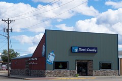 | Baker Hotel | building | 2005 | 04001435 |
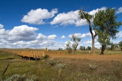 | Cottonwood Creek Bridge | structure | 2014 | 14000079 |
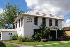 | Fallon County Jail | building | 1998 | 98000946 |
Every wildfire the federal occurrence database records inside this county: 80 of them, burning about 3,066 acres. 31 started naturally and none was recorded as arson. Each settlement page carries the fires within five miles of it.
| Reported cause | Fires |
|---|---|
| Natural | 31 |
| Equipment and vehicle use | 25 |
| Missing data/not specified/undetermined | 11 |
| Power generation/transmission/distribution | 5 |
| Fireworks | 3 |
| Misuse of fire by a minor | 2 |
| Debris and open burning | 2 |
| Railroad operations and maintenance | 1 |
The five largest, by the area the report gives. None of them was recorded as arson.
| Date | Cause | Size | Reported by | Name on the report |
|---|---|---|---|---|
| 1 September 2000 | Natural | 1,414 acres | Miles City Field Office | MC CREEK |
| 5 July 2012 | Natural | 882 acres | Eastern Land Office | BAKER |
| 5 August 2012 | Railroad operations and maintenance | 272 acres | Miles City Field Office | PLEVNA |
| 8 August 2008 | Power generation/transmission/distribution | 185 acres | Miles City Field Office | PENNEL |
| 31 March 1997 | Natural | 120 acres | Miles City Field Office | MYERS FIRE |
| 6 March 2016 | Debris and open burning | 24 acres | Eastern Land Office | BENSLEY CREEK - CUSTER |
| 14 July 1998 | Natural | 20 acres | Custer Gallatin National Forest | STORMY BUTTE |
| 19 August 1999 | Natural | 20 acres | Miles City Field Office | LAWRENCE |
Every settlement page carries the fires within five miles of it - see the settlement index below.
The NOAA Storm Events Database holds 348 reports for this county, causing no deaths, 7 injuries and about $3,463,000 in recorded property damage. Each settlement page carries the reports that name it.
| Kind of event | Reports |
|---|---|
| Hail | 184 |
| Thunderstorm Wind | 117 |
| Tornado | 14 |
| Flash Flood | 14 |
| Funnel Cloud | 13 |
| Heavy Rain | 5 |
| Flood | 1 |
The most serious of them, by death, then injury, then recorded damage. The accounts are quoted exactly as the forecast office filed them.
| When | Event | Place named | Harm | What the report says |
|---|---|---|---|---|
| June 2016 | Tornado (EF3) | Baker Arpt | 7 hurt, $1,500,000 | The pre-storm environment for eastern Montana was such that severe weather was likely. Surface dew point values in the Baker area were in the lower 60s with strong southeasterly flow converging in the vicinity of a stationary surface trough. This area of strong surface convergence, which also separated moist rich air to the east and drier air to the west, played a critical role in the development of this short-lived tornado. ||Although no fatalities occurred , seven injuries, some requiring hospitalization, resulted from the tornado. Two homes were totally destroyed and 40 to 50 more sustained excessive damage. The city blocks located between South 5th Street East and South 10th Street East intersected by Texas Avenue were hit the hardest and sustained the most damage. Many power poles were broken resulting in power lines down and power outages. Single tree trunks were described to look like match sticks as they were stripped of all branches and leaves. ||Over 70 personnel came with boots on the ground from the surrounding tri-state area. The communities of Plevna, Ekalaka, and Wibaux, Montana, Marmarth, Rhame, Bowman and Beach, North Dakota, as well as Ludlow, South Dakota responded shortly after the tornado. ||At the mesoscale level (2 to 2000 km in space), the interaction of pre-existing convergence zones or boundaries can serve as areas of storm development or enhancement. In some cases, pre-existing thunderstorms interacting with a boundary of converging surface winds can rapidly develop short-lived tornadoes with very little precursor indication from weather radar. The time scale of these events typically is on the order of a few minutes (0-10 minutes). ||In the case of the thunderstorms near Baker on Saturday, June 11th, evidence of these types of boundaries was observed. |
| July 2016 | Hail | Baker Arpt | $1,000,000 | Hail up to 2 inches in diameter along with 50 to 60 mph winds occurred at the Baker Airport. The hail was still two to three inches deep on the ground after the storm. Multiple hangers were damaged by the hail and wind. Several hangers received broken window damage. In addition, several vehicles at the airport were severely damaged with some windows of vehicles completely broken. A few of the vehicles were considered total losses. |
| May 2011 | Flood | Webster | $375,000 | Significant small stream flooding across much of Fallon County. Numerous roads closed and eventually washed out with additional damage reported to several bridges. Water breached a small dam and a couple private holding ponds in the region. Significant erosion threatened the Waste Water Treatment Plant in Baker. Significant flooding reported on O'Fallon Creek where one spotter reported the highest levels on the stream in at least 58 years with over a foot of water covering much of their farmland. At the Boxelder and Horse Creek confluence, flood waters rushed over dikes and into hayfields. Floodwaters surrounded one house in that region. Damage estimates based on FEMA reviews and Individual Assistance approvals. |
| July 1979 | Tornado (F1) | not stated | $250,000 | no account filed |
| July 1952 | Tornado | not stated | $250,000 | no account filed |
| August 1993 | Hail | Baker | $50,000 | Wind damage was widespread across Fallon County. |
| June 1977 | Tornado | not stated | $25,000 | no account filed |
| August 1993 | Thunderstorm Wind | Baker | $5,000 | Wind damage was widespread across Fallon County. |
| August 1993 | Hail | Baker | $5,000 | Wind damage was widespread across Fallon County. |
| July 2000 | Thunderstorm Wind | Plevna | $2,000 | Several trees downed |
| July 2000 | Thunderstorm Wind | Baker | $1,000 | Spotter northeast of Baker reported 4 inch diameter hail and 60+ mph winds. Backyard and frontyard flooded. |
| August 2025 | Thunderstorm Wind | Baker Arpt | - | Corrects the time on previous tstm wnd gst report from 1 SE Baker. asos station kbhk Baker. |
| June 2025 | Thunderstorm Wind | Willard | - | Weather Station report. |
| June 2025 | Hail | Webster | - | Facebook Report . |
| June 2025 | Hail | Webster | - | Hail report. |
| June 2025 | Hail | Webster | - | Hail report. |
| July 2025 | Hail | Plevna | - | Estimated hail that occurred near spotter. |
| July 2025 | Hail | Plevna | - | Estimated hail size. |
| July 2025 | Thunderstorm Wind | Baker Arpt | - | Asos weather station at Baker airport. |
| July 2025 | Thunderstorm Wind | Willard | - | Mesonet station mteka Baker Mt-7 mp 14.2 . |
| July 2025 | Thunderstorm Wind | Webster | - | Estimated gust by a spotter. |
| July 2025 | Hail | Baker | - | Quarter size hail reported. |
| July 2025 | Thunderstorm Wind | Webster | - | Estimated by a spotter. |
| July 2025 | Thunderstorm Wind | Webster | - | Tree damage reported with estimated maximum branch diameter of 5 inches. |
| July 2025 | Thunderstorm Wind | Baker Arpt | - | Asos weather station at Baker. |
| June 2025 | Thunderstorm Wind | Willard | - | Mesonet station Baker Mt-7 Mp 14.2. |
| July 2024 | Thunderstorm Wind | Baker | - | Power poles and large trees were downed. |
| June 2024 | Thunderstorm Wind | Baker | - | Tree and roof damage was reported. |
| September 2024 | Thunderstorm Wind | Baker Arpt | - | The Baker Airport reported a wind gust of 67 mph. |
| July 2022 | Flash Flood | Baker | - | County DES reported deep standing water and flooding in the town of Baker. |
| June 2021 | Thunderstorm Wind | Baker Arpt | - | Winds gusted to 67 mph at the Baker Airport. |
| June 2021 | Thunderstorm Wind | Baker Arpt | - | This was outflow winds from a cluster of thunderstorms to the east. |
| July 2021 | Hail | Ollie | - | The wind-driven hail broke windows on the house. |
| July 2021 | Thunderstorm Wind | Ollie | - | The wind-driven hail broke windows on the house. |
| July 2020 | Thunderstorm Wind | Baker Arpt | - | A wind gust of 60 mph was reported at the Baker airport. |
| July 2020 | Hail | Baker Arpt | - | Most of the hail was smaller. |
| July 2020 | Thunderstorm Wind | Baker | - | Several trees were uprooted and power lines were downed. The local farm and fleet store had a number of large stock tanks that traveled about 1/4 mile into town taking out a few fences. In addition, power was out in much of the town. |
| July 2018 | Thunderstorm Wind | Baker | - | Several trailers were blown over including a fireworks trailer. There was also brick damage to the top of a building. |
| July 2018 | Thunderstorm Wind | Webster | - | Tree limbs 12 inches in diameter were broken out of trees. |
| July 2016 | Thunderstorm Wind | Plevna | - | A moderate size tree was uprooted. |
| June 2016 | Thunderstorm Wind | Ollie | - | Some siding was blown off a house. |
| June 2016 | Hail | Ollie | - | Half dollar size hail fell near Ollie damaging several house windows. |
| July 2016 | Hail | Baker Arpt | - | A skylight was broken. |
| July 2016 | Thunderstorm Wind | Baker | - | Wind-driven golf ball size hail broke out windows on the west side of numerous homes in the town of Baker. |
| July 2016 | Hail | Plevna | - | A spotter reported broken windows in the home, as well as trees stripped of their leaves. |
| July 2016 | Tornado (EF0) | Baker Arpt | - | Multiple small spin-up tornadoes were observed. |
| June 2016 | Thunderstorm Wind | Baker Arpt | - | Shingles were blown off a house and pea size hail was reported 6 miles northeast of Baker. |
| July 2016 | Thunderstorm Wind | Baker Arpt | - | A few trees were reported down around the town of Baker. In addition, a roof of a local business was peeled back half way. |
| July 2016 | Tornado (EF0) | Webster | - | Several people reported a funnel cloud form and touchdown with obvious debris/dust/dirt picked up on top of a hill. |
| August 2016 | Thunderstorm Wind | Baker Arpt | - | Winds gusted between 60 and 70 mph continuously for about 10 minutes. |
| June 2015 | Tornado (EF0) | Willard | - | A weak tornado was reported between Baker and Ekalaka during the late afternoon hours on the 21st. The tornado was on the ground for around a minute. It began roping out about 4 minutes later and its circulation appeared to fully cut off around 90 seconds after that. |
| June 2015 | Hail | Westmore | - | Golf ball to tennis ball size hail 3 to 4 inches deep was reported along the road. Trees were completely stripped bare like winter time. Roadside reflectors were completely shattered all along Highway 12 at mile marker 55. |
| June 2015 | Thunderstorm Wind | Westmore | - | Nickel size hail was also reported. |
| July 2015 | Thunderstorm Wind | Baker Arpt | - | Thunderstorm wind gusts ranged from 58 mph to 66 mph. |
| July 2015 | Thunderstorm Wind | Westmore | - | Fifteen inch diameter trees in a shelter belt were snapped. In addition, one shed in the shelter belt had a door shredded and another shed lost its roof. |
| August 2014 | Thunderstorm Wind | Baker | - | The Sheriff Dispatch reported that an 18 inch diameter tree was uprooted, along with many tree branches down in Baker from the very strong winds. In addition, tin roofing material was ripped from the firehouse. |
| July 2014 | Thunderstorm Wind | Westmore | - | A large water tank was torn out and thrown into a field. In addition, numerous tree limbs were down. |
| July 2014 | Thunderstorm Wind | Westmore | - | A roof was blown off an old trailer house. Windows were blown out and holes were in the siding from wind-driven hail. Trees were also blown down with some branches stuck into the side of the house. In addition, a horse trailer rolled 50 to 70 yards. |
| July 2014 | Hail | Willard | - | Large hail resulted in severe damage to house and car windows, as well as an RV. Trees were stripped of leaves and some crops were destroyed. |
| June 2014 | Funnel Cloud | Westmore | - | Three funnel clouds came out of one cloud. |
The Survey's mineral resources record lists 15 workings inside this county. 2 still produce and 13 are closed or unrecorded. Each settlement page carries the workings within five miles of it.
| Commodity | Workings |
|---|---|
| Uranium | 12 |
| Pumice | 2 |
| Aluminum | 1 |
The least common of them first, because a county's hundredth gravel pit says nothing its first ten did not.
| Where | Site | Commodity | Status | Recorded |
|---|---|---|---|---|
| Fallon County Bentonite Deposit | Aluminum | Prospect | ||
| Singer Scoria Pit | Pumice | Producer | ||
| Zion Portable Crusher | Pumice | Producer | ||
| Burmac Exploration Corp. | Uranium | Occurrence | ||
| Cox Lease | Uranium | Occurrence | Tyuyamunite | |
| Cox Lease | Uranium | Occurrence | Stratabound | |
| Cox and Neary Ranches | Uranium | Occurrence | ||
| Lame Jones Creek | Uranium | Occurrence | ||
| Stark Lease | Uranium | Occurrence | Stratabound | |
| Unknown | Uranium | Occurrence | Stratabound | |
| Unknown | Uranium | Occurrence | ||
| Unknown | Uranium | Occurrence | ||
| Waldron | Uranium | Occurrence | ||
| Waldron Lease | Uranium | Occurrence | Stratabound | |
| Waldron, Cos, and Stark Leases | Uranium | Past Producer |
Named settlements recorded in the Geographic Names Information System, each with the topographic sheets covering it. Villages, hamlets and abandoned places alike. Each is shown with the nearest named watercourse or landform and the survey quadrangle it falls on.
Baker census division · 59313 · On Wills Creek · Lawrence Creek East quadrangle
8 sheets, 1953 to 1981
Baker census division · 59313 · Snider Hill quadrangle
8 sheets, 1954 to 1982
No longer a settlement
Plevna census division · 59336 · On Spring Creek · Harmon Butte quadrangle
8 sheets, 1953 to 1981
No longer a settlement
Baker census division · 59313 · On Fork of Beaver Creek · Ollie quadrangle
9 sheets, 1953 to 1997
Plevna census division · 59344 · On South Fork Sandstone Creek · Plevna quadrangle
8 sheets, 1953 to 1981
The vanished settlements of Fallon County: the places named above that are no longer on the map.