 Block
From the record
9 National Register listings published here.
Sources: the National Register database, National Park Service
59 topographic sheets cover 33 settlements here, and 9 properties are on the National Register of Historic Places.
9 National Register listings published here.
Sources: the National Register database, National Park Service
Every property in this county listed on the National Register of Historic Places, with the year it was listed and the federal nomination document.
| Photograph | Property | Type | Listed | Reference |
|---|---|---|---|---|
 | Carnegie Public Library | building | 1986 | 86001934 |
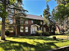 | H. Earl Clack House | building | 1985 | 85003385 |
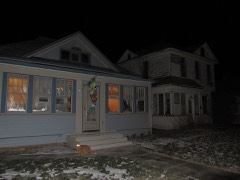 | Havre Residential Historic District | district | 1989 | 89001630 |
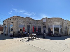 | Heltne Oil Company | building | 1994 | 94000865 |
| Kiwanis Meeting Hall | building | 2010 | 10000133 | |
| Northern Montana College Girls Residence Hall | building | 2024 | 100010160 | |
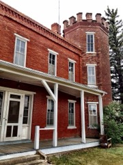 | Officer's Amusement Hall | building | 1989 | 89000040 |
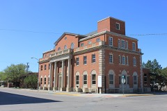 | US Post Office and Courthouse-Havre Main | building | 1986 | 86000682 |
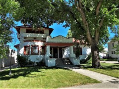 | Young-Almas House | building | 1980 | 80002421 |
Every wildfire the federal occurrence database records inside this county: 771 of them, burning about 30,672 acres. 54 started naturally and 138 were recorded as arson. Each settlement page carries the fires within five miles of it.
| Reported cause | Fires |
|---|---|
| Debris and open burning | 248 |
| Arson/incendiarism | 138 |
| Missing data/not specified/undetermined | 82 |
| Fireworks | 82 |
| Misuse of fire by a minor | 73 |
| Natural | 54 |
| Equipment and vehicle use | 47 |
| Recreation and ceremony | 18 |
| Other causes | 12 |
| Smoking | 10 |
| Power generation/transmission/distribution | 6 |
| Firearms and explosives use | 1 |
The five largest, by the area the report gives. None of them was recorded as arson.
| Date | Cause | Size | Reported by | Name on the report |
|---|---|---|---|---|
| 27 August 2017 | Missing data/not specified/undetermined | 18,915 acres | Rocky Boy's Agency | EAST FORK |
| 30 March 2012 | Missing data/not specified/undetermined | 2,034 acres | Malta Field Office | BIG STRETCH |
| 30 March 2012 | Natural | 1,760 acres | Rocky Boy's Agency | BILLY RANCH FIRE |
| 16 July 2019 | Missing data/not specified/undetermined | 1,300 acres | Hill County | FDH-MTLG12-64 |
| 24 August 1999 | Debris and open burning | 1,200 acres | Rocky Boy's Agency | SHIRLEY |
| 27 August 2020 | Equipment and vehicle use | 1,000 acres | Hill County | FDH-MTLG12-294 |
| 26 August 2017 | Equipment and vehicle use | 600 acres | Northeastern Land Office | not named |
| 30 July 2019 | Missing data/not specified/undetermined | 500 acres | Hill County | FDH-MTLG12-97 |
Every settlement page carries the fires within five miles of it - see the settlement index below.
The NOAA Storm Events Database holds 343 reports for this county, causing no deaths, 1 injury and about $4,062,750 in recorded property damage. Each settlement page carries the reports that name it.
| Kind of event | Reports |
|---|---|
| Thunderstorm Wind | 200 |
| Hail | 112 |
| Heavy Rain | 11 |
| Tornado | 7 |
| Flood | 6 |
| Funnel Cloud | 5 |
| Flash Flood | 2 |
The most serious of them, by death, then injury, then recorded damage. The accounts are quoted exactly as the forecast office filed them.
| When | Event | Place named | Harm | What the report says |
|---|---|---|---|---|
| September 2004 | Thunderstorm Wind | Havre | 1 hurt, $10,000 | no account filed |
| April 2023 | Flood | Laredo | $2,000,000 | Mountain snowpack in the Milk River basin melted out very quickly and contributed significant flooding. Virtually the entire Milk River system flooded in a matter of days as a result, starting near the headwaters in Hill County. Big Sandy Creek near Havre crested at 12.07 feet on April 13, which (as of entry) was the fourth highest crest on record. Route 50 was greatly flooded as well as some businesses . Farther north, Lodge Creek below McRae Creek approached Major Flood stage before cresting at 10.59 feet on April 18th. Much of rural northern Hill County experienced flooding as a result. The Milk River gauge near Havre remained below flood stage, although river levels did come out of their banks farther east, ultimately impacting eastern portions of Havre. |
| May 2024 | Flood | Rocky Boy | $1,210,000 | Hill County Department of Emergency Services and MT Department of Emergency Services reported flooding in and around the Bears Paw Mountains. Total damage done totaled $1,205,267. The main expenses were to roads & bridges ($368,000) and to parks, recreational, or other facilities ($836,000). |
| May 1980 | Tornado (F1) | not stated | $250,000 | no account filed |
| June 1998 | Flash Flood | Havre | $233,000 | no account filed |
| June 2003 | Thunderstorm Wind | Havre | $200,000 | no account filed |
| June 1994 | Hail | Gildford | $50,000 | no account filed |
| August 2023 | Thunderstorm Wind | Hingham | $45,000 | A 40 x 60 metal shed destroyed from collapsing thunderstorm wind gusts. Nearby observations recorded wind gusts in excess of 70 mph. |
| August 1999 | Thunderstorm Wind | Box Elder | $40,000 | OVERTURNED A TRAILER...DAMAGED FENCES AND ROOFS |
| June 2022 | Thunderstorm Wind | Haure Afs | $20,000 | Two power poles snapped at the base. Road signs reported to be blown over. |
| August 1992 | Tornado (F0) | not stated | $2,500 | no account filed |
| June 2004 | Thunderstorm Wind | Hingham | $1,000 | no account filed |
| September 2004 | Hail | Simpson | $1,000 | no account filed |
| July 1962 | Tornado | not stated | $250 | no account filed |
| May 2025 | Thunderstorm Wind | Rudyard | - | Mesonet station EW1931 Rudyard measured a 63 mph thunderstorm wind gust. |
| May 2025 | Thunderstorm Wind | (Hvr)Havre City-Co A | - | ASOS station KHVR Havre Airport measured a 61 mph wind gust. |
| August 2025 | Thunderstorm Wind | Cold Stone | - | Mesonet station EW1937 Goldstone peak gust. |
| August 2025 | Thunderstorm Wind | Simpson | - | Montana mesonet station Kremlin NW peak gust. |
| August 2025 | Thunderstorm Wind | Inverness | - | Montana mesonet station Inverness N peak gust. |
| August 2025 | Thunderstorm Wind | Gildford | - | Mesonet station GW6391 Gildford 10n peak gust. |
| July 2025 | Thunderstorm Wind | Simpson | - | Mesonet station GW6392 Gildford 15n measured a 59 mph wind gust. |
| July 2025 | Thunderstorm Wind | Inverness | - | MT DOT weather station (Inverness US-2 MP 337.6) measured a 58 mph wind gust. |
| July 2025 | Flood | (Hvr)Havre City-Co A | - | Broadcast Media reposted photos and videos of flooding in the town of Havre due to a thunderstorm producing heavy rainfall. Emergency managers reported that the flooding was confined to the town of Havre and water rose up to 3.25 on streets. No specific damages or injuries were reported due to the flood. |
| August 2025 | Thunderstorm Wind | Simpson | - | Montana mesonet station Simpson peak gust. |
| August 2025 | Thunderstorm Wind | Havre | - | Montana mesonet station Lake Thubadeau W peak gust. |
| August 2025 | Thunderstorm Wind | Inverness | - | Mesonet station GW4079 Inverness 10 SE. |
| August 2025 | Thunderstorm Wind | (Hvr)Havre City-Co A | - | ASOS station KHVR Havre Airport initial severe gust. |
| August 2025 | Thunderstorm Wind | Assinniboine | - | MT mesonet southwest of Havre. |
| August 2025 | Thunderstorm Wind | (Hvr)Havre City-Co A | - | Peak gust at Asos station KHVR Havre Airport. |
| August 2025 | Hail | Havre | - | Social media picture of hail approximated to be 1.25 inches or a bit larger 1 mile south of Havre. Time estimated using radar. |
| August 2025 | Thunderstorm Wind | (Hvr)Havre City-Co A | - | ASOS station KHVR Havre Airport. Peak gust at the asos. |
| July 2024 | Thunderstorm Wind | (Hvr)Havre City-Co A | - | ASOS station KHVR measured a severe caliber gust. |
| July 2024 | Hail | Havre | - | Public report of golf ball to baseball sized hail that lasted about ten minutes. Hail completely covered the ground. |
| July 2024 | Hail | Haure Afs | - | Public report from social media. Location was estimated based on the report time given by the public and radar data. |
| July 2024 | Hail | Havre | - | Reported via social media with images. Time estimated via radar. |
| July 2024 | Hail | Havre | - | Facebook report. |
| July 2024 | Hail | Havre | - | Social media report showing golf ball to egg sized hail that lasted for about 12 minutes. 0.2 inches of rain with the storm. |
| July 2024 | Hail | Havre | - | Quarter to golf ball sized hail was reported by a trained spotter. Hail was reported to be completely covering the ground. |
| September 2024 | Thunderstorm Wind | (Hvr)Havre City-Co A | - | ASOS station KHVR Havre Airport measured a 54 kt gust. |
| September 2024 | Thunderstorm Wind | (Hvr)Havre City-Co A | - | ASOS station KHVR Havre Airport measured a 54 kt gust. |
| August 2024 | Thunderstorm Wind | Rudyard | - | Mesonst station GW3530 Rudyard 11 S measured a severe caliber gust. |
| August 2024 | Thunderstorm Wind | (Hvr)Havre City-Co A | - | ASOS station KHVR Haver Airport measured a severe caliber gust. |
| June 2023 | Funnel Cloud | Box Elder | - | Public submitted photos of a funnel cloud near Rocky Boy, taken from Highway 87. |
| June 2023 | Tornado (EFU) | Box Elder | - | Broadcast media submitted photos of tornado across rural Hill County. Two additional funnel clouds were filmed near the ongoing tornado. Due to limited access to the touchdown area, no storm survey was able to be conducted. Movement was to the west/northwest and was associated with a strengthening thunderstorm. |
| July 2023 | Thunderstorm Wind | Fresno | - | Recorded by automated system on southeast end of Fresno Reservoir. |
| August 2023 | Thunderstorm Wind | Rudyard | - | Measured by site EW1931 Rudyard. |
| August 2023 | Thunderstorm Wind | (Hvr)Havre City-Co A | - | Measured by Havre Airport ASOS station khvr. |
| August 2022 | Thunderstorm Wind | Haure Afs | - | Mesonet station kmthavre60. |
| August 2022 | Thunderstorm Wind | Cold Stone | - | Mesonet fw1664 Hingham. |
| August 2022 | Thunderstorm Wind | Cold Stone | - | An Ambient weather station measured a 70 mph gust in northern Hill county. |
| September 2022 | Thunderstorm Wind | Inverness | - | Mesonet station MTINV Inverness reported 68 knot wind gust. |
| July 2022 | Hail | Cold Stone | - | Public report of 1.5 inch hail 15 miles N of Rudyard. |
| July 2022 | Thunderstorm Wind | (Hvr)Havre City-Co A | - | Trained spotter reported lightning, pea sized hail, with a rain rate of 3-5 in/hr. Sustained winds of 70 mph, with a 90 mph gust. |
| July 2022 | Thunderstorm Wind | Havre | - | Trained spotter reported 81 mph wind gust 1 mile ENE of Havre. |
| June 2022 | Thunderstorm Wind | Cold Stone | - | Gust measured at mesonet station FW1664 Hingham. |
| June 2022 | Thunderstorm Wind | Cold Stone | - | Wind gust measured at mesonet station EW1937 Goldstone. |
| June 2022 | Thunderstorm Wind | Cold Stone | - | Gust measured via an Ambient sensor. |
| June 2022 | Thunderstorm Wind | Haure Afs | - | Public report of two power poles snapped at the base on mt highway 232 at mile marker 21. Additionally, signs were reported to be blown over. Time estimated via radar. |
| June 2022 | Heavy Rain | Rocky Boy | - | Spotter reported 3.5 inches rain accumulation. |
| June 2022 | Thunderstorm Wind | (Hvr)Havre City-Co A | - | ASOS station khvr Havre Airport. |
The Survey's mineral resources record lists 17 workings inside this county. 2 still produce and 15 are closed or unrecorded. Each settlement page carries the workings within five miles of it.
| Commodity | Workings |
|---|---|
| Sand and Gravel, Construction | 10 |
| Lead | 2 |
| Niobium (Columbium) | 1 |
| Zinc, Zirconium, Niobium (Columbium), Uranium, Copper, Lead, Titanium, Metal | 1 |
| Aluminum | 1 |
| Silver | 1 |
| Arsenic, Gold, Silver | 1 |
| Stone, Crushed/Broken | 1 |
| Uranium | 1 |
| Tantalum, Niobium (Columbium), Vermiculite | 1 |
The least common of them first, because a county's hundredth gravel pit says nothing its first ten did not.
| Where | Site | Commodity | Status | Recorded |
|---|---|---|---|---|
| Nepheline Occurrences | Aluminum | Occurrence | ||
| Number One | Uranium, Tantalum, Niobium (Columbium), Vermiculite | Prospect | ||
| Rainbow Claims | Silver, Lead | Occurrence | ||
| Rainbow Claims | Lead, Arsenic, Gold, Silver | Prospect | ||
| Rocky Boy Stock | Niobium (Columbium) | Occurrence | ||
| Unnamed | Zinc, Zirconium, Niobium (Columbium), Uranium, Copper, Lead, Titanium, Metal | Occurrence | Pyrite, Pyrrhotite | |
| Unnamed | Stone, Crushed/Broken | Occurrence | ||
| Gravel Pit | Sand and Gravel, Construction | Unknown | ||
| Gravel Pit | Sand and Gravel, Construction | Unknown | ||
| Gravel Pit | Sand and Gravel, Construction | Unknown | ||
| Gravel Pit | Sand and Gravel, Construction | Unknown | ||
| Gravel Pit | Sand and Gravel, Construction | Unknown | ||
| Gravel Pit | Sand and Gravel, Construction | Unknown | ||
| Gravel Pit | Sand and Gravel, Construction | Unknown | ||
| Gravel Pits | Sand and Gravel, Construction | Unknown | ||
| Havre Sand and Gravel Pit | Sand and Gravel, Construction | Producer | ||
| Warhawk Rambo Pit | Sand and Gravel, Construction | Producer |
Named settlements recorded in the Geographic Names Information System, each with the topographic sheets covering it. Villages, hamlets and abandoned places alike. Each is shown with the nearest named watercourse or landform and the survey quadrangle it falls on.
Rocky Boy's census division · 59521 · Near Big Knife Coulee · Rocky Boy quadrangle
9 sheets, 1953 to 1993
Havre census division · 59501 · On Big Sandy Creek · Herron Park quadrangle
11 sheets, 1904 to 1984
Rudyard census division · 59540 · Rocky Coulee SW quadrangle
6 sheets, 1954 to 1984
No longer a settlement
Havre census division · 59501 · On Big Sandy Creek · Herron Park quadrangle
11 sheets, 1904 to 1984
No longer a settlement
Wild Horse Lake census division · 59501 · Lake Thibadeau quadrangle
8 sheets, 1912 to 1984
Gildford census division · 59525 · Near Tommy Allen Coulee · Ninemile Coulee West quadrangle
8 sheets, 1920 to 1984
Havre census division · 59501 · Near Indian Woman Coulee · Herron Park quadrangle
11 sheets, 1904 to 1984
Wild Horse Lake census division · 59501 · Hilldale Colony quadrangle
8 sheets, 1912 to 1984
Rocky Boy's census division · 59501 · On Laredo Flats · Laredo quadrangle
10 sheets, 1953 to 1993
Rudyard census division · 59530 · Laird Lake quadrangle
7 sheets, 1919 to 1984
No longer a settlement
Havre census division · 59501 · Shambo NE quadrangle
10 sheets, 1953 to 1993
No longer a settlement
Havre census division · 59501 · Near Black Butte · Herron Park quadrangle
11 sheets, 1904 to 1984
Rocky Boy's census division · 59521 · On Daychild Creek · Rocky Boy quadrangle
9 sheets, 1953 to 1993
Havre census division · 59501 · On Saddle Butte · Havre quadrangle
11 sheets, 1904 to 1984
Rocky Boy's census division · 59521 · Near Oosahquapahmoo Ridge · Centennial Mountain quadrangle
10 sheets, 1953 to 1993
Rocky Boy's census division · 59521 · Near Saint Pierre Coulee · Rocky Boy quadrangle
9 sheets, 1953 to 1993
Havre census division · 59501 · On Shambo Mountain · Bearpaw Lake quadrangle
10 sheets, 1953 to 1993
No longer a settlement
Havre census division · 59501 · Near Shambo Mountain · Bearpaw Lake quadrangle
10 sheets, 1953 to 1993
Havre census division · 59501 · On Beaver Creek · Havre quadrangle
11 sheets, 1904 to 1984
The vanished settlements of Hill County: the places named above that are no longer on the map.