 Block
From the record
3 National Register listings published here.
Sources: the National Register database, National Park Service
34 topographic sheets cover 13 settlements here, and 3 properties are on the National Register of Historic Places.
3 National Register listings published here.
Sources: the National Register database, National Park Service
Every property in this county listed on the National Register of Historic Places, with the year it was listed and the federal nomination document.
| Photograph | Property | Type | Listed | Reference |
|---|---|---|---|---|
 | Grandey Elementary School | building | 1978 | 78001689 |
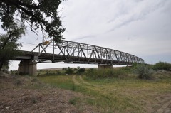 | Powder River Bridge | structure | 2010 | 09001186 |
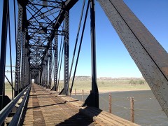 | Yellowstone River Bridge | structure | 2010 | 09001187 |
Every wildfire the federal occurrence database records inside this county: 126 of them, burning about 10,517 acres. 66 started naturally and none was recorded as arson. Each settlement page carries the fires within five miles of it.
| Reported cause | Fires |
|---|---|
| Natural | 66 |
| Equipment and vehicle use | 35 |
| Missing data/not specified/undetermined | 10 |
| Railroad operations and maintenance | 4 |
| Power generation/transmission/distribution | 4 |
| Debris and open burning | 4 |
| Firearms and explosives use | 1 |
| Smoking | 1 |
| Other causes | 1 |
The five largest, by the area the report gives. None of them was recorded as arson.
| Date | Cause | Size | Reported by | Name on the report |
|---|---|---|---|---|
| 6 July 2006 | Railroad operations and maintenance | 833 acres | Miles City Field Office | O FALLON |
| 16 February 1995 | Debris and open burning | 700 acres | Eastern Land Office | FEBRUARY |
| 25 August 2017 | Natural | 659 acres | Miles City Field Office | SAGEBRUSH DRAW |
| 26 March 2007 | Debris and open burning | 622 acres | Miles City Field Office | DINOSAUR |
| 12 August 2017 | Natural | 606 acres | Miles City Field Office | CHERRY |
| 16 February 1995 | Missing data/not specified/undetermined | 545 acres | Miles City Field Office | CAMP CREEK |
| 12 July 2015 | Equipment and vehicle use | 464 acres | Miles City Field Office | MM 172 |
| 29 August 1995 | Natural | 400 acres | Miles City Field Office | MILDRED |
Every settlement page carries the fires within five miles of it - see the settlement index below.
The NOAA Storm Events Database holds 337 reports for this county, causing no deaths, no injuries and about $714,000 in recorded property damage. Each settlement page carries the reports that name it.
| Kind of event | Reports |
|---|---|
| Hail | 185 |
| Thunderstorm Wind | 118 |
| Flash Flood | 13 |
| Heavy Rain | 8 |
| Flood | 8 |
| Tornado | 3 |
| Wildfire | 1 |
| Funnel Cloud | 1 |
The most serious of them, by death, then injury, then recorded damage. The accounts are quoted exactly as the forecast office filed them.
| When | Event | Place named | Harm | What the report says |
|---|---|---|---|---|
| June 2005 | Thunderstorm Wind | Terry | $145,000 | Damaging thunderstorm winds blew over a pivot sprinkler. The strong wind destoyed one machine shed. There were multiple reports of structural damage to occupied and unoccupied structures. A couple of cars were damaged from fallen tree limbs. |
| May 2005 | Thunderstorm Wind | Mc Cloud | $132,000 | Damage to three pivot irrigators. |
| June 2006 | Thunderstorm Wind | Terry | $120,000 | A severe thunderstorm moved into southern Prairie county and raced off to the northeast at 50 mph. As the storm first entered the county it produced wind damage 12 miles southwest of Terry at 5:12 pm. A National Weather employee reported a pole barn was significantly damaged at a family members home. The poles were pulled right out of the ground. A shed was also destroyed on the property. As the storm continued to track off to the northeast it produced wind gusts in excess of 80 mph. At 5:30 pm an 88 mph wind gust was measured in Terry. Numerous tree branches were downed in the area, and many homes had minor roof damage. |
| May 2011 | Tornado (EF1) | Terry | $75,000 | At approximately 8:27pm on May 20, a tornado struck a ranch 8 miles south of Terry on 10 Mile Road. The tornado was observed by a resident of the house on the ranch. The house itself received no damage, though it was about 150 feet away from observed damage. Significant damage occurred to 4 outbuildings on the ranch. There were no injuries and the horses on the ranch were uninjured as they were out in pasture at the time of the tornado. The damage path was about 500 feet and the width was 200 feet. Based on the damage, the wind speed was determined to be 90 mph or a low end EF-1 tornado. |
| July 1997 | Flash Flood | Terry | $50,000 | Six inches of rain in less than 4 hours caused flash flooding. The town of Terry was inundated. Both Terry and Fallon reported extensive street flooding. A section of Interstate 90 by Terry had water running across it. Several washouts were reported on gravel county roads. |
| August 1993 | Thunderstorm Wind | Terry | $50,000 | Trees were blown down and a trailer was blown over. Heavy rain fell causing Cherry Creek to run over the road north of Terry. |
| May 2006 | Flash Flood | Mc Cloud | $30,000 | 2 feet of water running over north folk of Cherry Creek Road. Considerable damage was caused to outbuildings. One culvert was washed out and the roads needed repair in several areas where the water ran across them. Many fences and watering tanks were destroyed. |
| June 2005 | Flash Flood | Terry | $30,000 | Water flowed over Highway 253 northwest of Terry, and caused damage to the highway. |
| July 1955 | Tornado (F1) | not stated | $25,000 | no account filed |
| July 1998 | Hail | Mildred | $12,000 | A severe thunderstorm produced golf ball sized hail and gusty winds. A large dead elm tree was blown down and a roof was blown off of a steel building. Several small trees were also blown down. Wheat crops in the area suffered devastating damage. |
| July 2008 | Thunderstorm Wind | Mildred | $10,000 | Wind tore a solid roof off a barn and drove a 2x6 foot wood beam 1.5 inches into a tree. |
| July 2001 | Flash Flood | East Portion | $10,000 | Heavy rainfall of 2 to 4 inches caused ditches to fill up and water to start running up to two feet deep across Highway 10 east of Terry. Some damage occurred to the road, but it was not washed out. |
| July 2007 | Thunderstorm Wind | Terry | $6,000 | The wind blew down 6 power poles between Terry and Fallon. |
| April 2007 | Thunderstorm Wind | Terry | $5,000 | A thunderstorm was dying and the outflow winds from it damaged a 14' by 44' hog shed and pushed it 75 feet from its slab. The nearest measured wind was at the Miles City Airport with a gust of 48 mph. Other buildings in the area were not damaged at all and no other reports of severe weather occurred in the area. |
| June 2005 | Thunderstorm Wind | Terry | $5,000 | A small grain bin was tossed into a grain field and destroyed. |
| August 1993 | Thunderstorm Wind | Terry | $5,000 | no account filed |
| September 2009 | Hail | Mc Cloud | $2,000 | Storm produced quarter-size hail and damaged a pick-up truck on the property. |
| July 2008 | Hail | Terry | $1,000 | Some windows were broken. |
| July 2007 | Hail | Fallon | $1,000 | The hail destroyed a kitchen window. |
| July 2025 | Thunderstorm Wind | Terry | - | Winds estimated to be at least 60 mph based on video posted to social media and tree limb damage reported by public. |
| July 2025 | Thunderstorm Wind | Terry | - | County Emergency management shared multiple damage reports from the town of Terry, including downed branches from multiple trees, a downed main power line causing a power outage, a peeled tin roof at the local baseball field. Time is estimated. Wind speed estimated at 65 mph. |
| July 2025 | Thunderstorm Wind | Bluffport | - | A wind gust of 58 mph was recorded at the BLM Terry mesonet site. |
| July 2025 | Hail | Blatchford | - | Public reported hail up to the size of quarters, lasting for 15 to 20 minutes. |
| July 2025 | Hail | Sutherland | - | Public reported golf ball size hail. |
| July 2025 | Hail | Terry | - | Trained spotter reported hail up to the size of quarters and heavy rain. |
| July 2025 | Hail | Terry | - | Public reported quarter size hail through the mPING system. |
| July 2025 | Hail | Kamm | - | Public reported ping pong ball size hail through the mPING system. |
| July 2025 | Thunderstorm Wind | Mc Cloud | - | A wind gust of 69 mph was measured at the Big Sheep Mountain RAWS site (LCFM8). |
| August 2025 | Thunderstorm Wind | Mc Cloud | - | A trained spotter estimated wind gusts of 50 to 60 mph which broke off some tree limbs. |
| August 2025 | Hail | Mc Cloud | - | A trained spotter reported quarter size hail. |
| June 2024 | Thunderstorm Wind | Terry | - | Prairie County DES estimated thunderstorm wind gusts of 60 mph. |
| June 2024 | Thunderstorm Wind | Terry | - | Public reported, via Facebook, an estimated 60 mph thunderstorm wind gust. |
| June 2024 | Thunderstorm Wind | Mildred | - | Public reported that the wind lofted the roof of barn. Pieces of the roof were scattered up to half a mile away. |
| June 2024 | Thunderstorm Wind | Bluffport | - | The BLM Terry mesonet site (MTM29) measured a 60 mph thunderstorm wind gust. |
| June 2023 | Flood | Bluffport | - | An emergency manager in Prairie County reported heavy rainfall caused water to flow over Interstate 94 at mile marker 181. |
| August 2023 | Thunderstorm Wind | Bluffport | - | The BLM Terry Mesonet site (MTM29) measured a 58 mph thunderstorm wind gust. |
| August 2023 | Thunderstorm Wind | Blatchford | - | The public reported, via social media, that an open faced barn (shed) had blown down. The shed was laying over a tractor, four wheeler and bike. Wind speeds were estimated at 70 mph, and the time of the event was estimated by radar data. |
| July 2022 | Hail | Mc Cloud | - | A trained spotter reported hail up to the size of quarters. |
| July 2022 | Thunderstorm Wind | Mc Cloud | - | A trained spotter estimated a thunderstorm wind gust of 60 mph. |
| July 2022 | Thunderstorm Wind | Kamm | - | A trained spotter estimated a thunderstorm wind gust of 75 mph. |
| July 2022 | Hail | Kamm | - | A trained spotter reported hail up to the size of quarters. |
| July 2022 | Thunderstorm Wind | Mc Cloud | - | Public reported, via Facebook, a thunderstorm wind gust estimated at 70 mph. |
| July 2022 | Hail | Terry | - | Public reported, via Facebook, hail up to the size of quarters. |
| July 2022 | Hail | Mildred | - | A trained spotter reported hail up to the size of quarters. |
| July 2022 | Hail | Mc Cloud | - | Public reported hail up to the size of quarters, as well as boards taken off of a fence. |
| July 2022 | Hail | Mc Cloud | - | A trained spotter reported hail up to the size of quarters. They also reported some small branches broken off of some trees. |
| July 2022 | Thunderstorm Wind | Mc Cloud | - | A trained spotter estimated thunderstorm wind gusts of 60 mph along with pea size hail. |
| July 2022 | Thunderstorm Wind | Mc Cloud | - | A trained spotter measured a thunderstorm wind gust of 70 mph. |
| July 2022 | Hail | Terry | - | A trained spotter reported, via Facebook, hail up to the size of quarters. |
| June 2021 | Thunderstorm Wind | Mc Cloud | - | The Big Sheep Mountain RAWS site (LCFM8), recorded a 70 mph thunderstorm wind gust. |
| June 2021 | Hail | Mc Cloud | - | Public reported, via Facebook, hail up to the size of baseballs. Time is estimated. |
| June 2021 | Hail | Mc Cloud | - | Trained spotter reported tea cup size hail, along with torrential rainfall. |
| June 2021 | Thunderstorm Wind | Mc Cloud | - | Trained spotter reported multiple trees damaged: Ash trees snapped; Apple trees blown down; and an 80-year old spruce tree blown down. |
| June 2021 | Hail | Mc Cloud | - | Trained spotter reported hen egg size hail. |
| July 2021 | Hail | Mildred | - | Public reported ping pong size hail. Time estimated from radar. |
| July 2021 | Heavy Rain | Mildred | - | Public reported 2 inches of rain fell during a two hour period. The rain came in two waves with most of it falling during the first 30 minutes. Time estimated from radar. |
| July 2021 | Thunderstorm Wind | Mildred | - | Multiple well established cottonwood trees on a property, ranging from 30 to 40 feet tall and 1 to 3 feet in diameter were uprooted or blown over. Estimated wind was 70mph. |
| June 2021 | Thunderstorm Wind | Mc Cloud | - | Big Sheep Mountain RAWS site (LCFM8) recorded a 59 mph thunderstorm wind gust. |
| May 2020 | Hail | Mc Cloud | - | Trained spotter reported quarter size hail. |
| May 2020 | Thunderstorm Wind | Mc Cloud | - | At the Big Sheep Mountain RAWS site (LCFM8), a 65 mph wind gust was measured. |
Named settlements recorded in the Geographic Names Information System, each with the topographic sheets covering it. Villages, hamlets and abandoned places alike. Each is shown with the nearest named watercourse or landform and the survey quadrangle it falls on.
Terry South census division · 59349 · By Devils Backbone · Kinsey NE quadrangle
8 sheets, 1953 to 1980
Terry South census division · 59349 · On Gate Coulee · Zero quadrangle
8 sheets, 1953 to 1980
Terry South census division · 59326 · On Deer Creek · Fallon SW quadrangle
9 sheets, 1953 to 1980
Terry North census division · 59349 · On Camp Creek · Calypso quadrangle
8 sheets, 1953 to 1980
Terry North census division · 59301 · On Whites Creek · Crow Rock quadrangle
8 sheets, 1954 to 1983
Terry South census division · 59326 · Near Plum Coulee · Fallon quadrangle
10 sheets, 1953 to 1980
Terry North census division · 59349 · On North Fork Cherry Creek · McCloud quadrangle
8 sheets, 1953 to 1980
Terry North census division · 59349 · Becker Dam quadrangle
6 sheets, 1954 to 1983
No longer a settlement
Terry North census division · 59349 · On Batchelor Creek · Zero quadrangle
8 sheets, 1953 to 1980
Terry South census division · 59349 · On Swede Creek · Spring Draw quadrangle
8 sheets, 1953 to 1980
No longer a settlement
Terry South census division · 59349 · By Devils Backbone · Zero quadrangle
8 sheets, 1953 to 1980
The vanished settlements of Prairie County: the places named above that are no longer on the map.