 Block
From the record
6 National Register listings published here.
Sources: the National Register database, National Park Service
38 topographic sheets cover 20 settlements here, and 6 properties are on the National Register of Historic Places.
6 National Register listings published here.
Sources: the National Register database, National Park Service
Every property in this county listed on the National Register of Historic Places, with the year it was listed and the federal nomination document.
| Photograph | Property | Type | Listed | Reference |
|---|---|---|---|---|
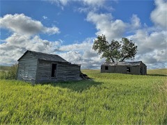 | Comertown Historic District | district | 1993 | 93001149 |
| Aage and Kristine Larsen Homestead | building | 1993 | 93001146 | |
| Outlook Depot | building | 1993 | 93001144 | |
| Raymond Grain Elevators Historic District | district | 1993 | 93001148 | |
| Rocky Valley Lutheran Church | building | 1993 | 93001145 | |
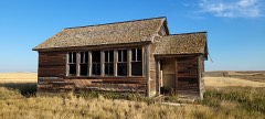 | Thornwood School | building | 1993 | 93001147 |
Every wildfire the federal occurrence database records inside this county: 61 of them, burning about 9,338 acres. 15 started naturally and 6 were recorded as arson. Each settlement page carries the fires within five miles of it.
| Reported cause | Fires |
|---|---|
| Equipment and vehicle use | 20 |
| Natural | 15 |
| Missing data/not specified/undetermined | 10 |
| Arson/incendiarism | 6 |
| Debris and open burning | 5 |
| Power generation/transmission/distribution | 2 |
| Fireworks | 1 |
| Recreation and ceremony | 1 |
| Railroad operations and maintenance | 1 |
The five largest, by the area the report gives. None of them was recorded as arson.
| Date | Cause | Size | Reported by | Name on the report |
|---|---|---|---|---|
| 31 October 1999 | Railroad operations and maintenance | 6,952 acres | Northeastern Land Office | OUTLOOK |
| 3 May 2002 | Equipment and vehicle use | 1,200 acres | Medicine Lake National Wildlife Refuge | BRUSHLAKE |
| 13 April 2006 | Natural | 255 acres | Medicine Lake National Wildlife Refuge | SOUTH LAKE |
| 5 November 1995 | Equipment and vehicle use | 153 acres | Northeast Montana Wetland Management District | MALL-POND |
| 27 July 2017 | Missing data/not specified/undetermined | 104 acres | Northeastern Land Office | not named |
| 21 April 2000 | Equipment and vehicle use | 100 acres | Medicine Lake National Wildlife Refuge | NORTHROOT |
| 9 August 2000 | Equipment and vehicle use | 92 acres | Fort Peck Agency | W MED LAKE |
| 10 July 2006 | Natural | 91 acres | Medicine Lake National Wildlife Refuge | CLARK |
Every settlement page carries the fires within five miles of it - see the settlement index below.
The NOAA Storm Events Database holds 357 reports for this county, causing 2 deaths, 3 injuries and about $6,507,250 in recorded property damage. Each settlement page carries the reports that name it.
| Kind of event | Reports |
|---|---|
| Hail | 197 |
| Thunderstorm Wind | 123 |
| Tornado | 10 |
| Flood | 9 |
| Heavy Rain | 6 |
| Funnel Cloud | 6 |
| Flash Flood | 4 |
| Wildfire | 1 |
| Lightning | 1 |
The most serious of them, by death, then injury, then recorded damage. The accounts are quoted exactly as the forecast office filed them.
| When | Event | Place named | Harm | What the report says |
|---|---|---|---|---|
| July 2010 | Tornado (EF3) | Redstone Hill Dot | 2 killed, 1 hurt, $300,000 | This was the deadliest tornado in Montana since 1923, and only the fourth EF-3 on record. The supercell thunderstorm developed strong rotation, and rotating wall clouds and brief funnel clouds were reported in Daniels County. As the storm moved southeast, it intensified and a large, long-lived tornado formed. The tornado traveled for 18 miles, mostly through rural areas, but it had devastating impacts as it hit a ranch, killing two people and injuring one. On the morning of July 27th, 2010 two teams of NWS Glasgow staff surveyed the damage area. The first team started in Daniels County and followed the track of the storm to the east-southeast. The second team met with county and state officials at the site of the ranch that was most devastated. Both teams spoke to law enforcement officials, as well as weather spotters and the public who had reports of weather and/or damage as well as those who saw the tornado. ||The initial damage from the tornado originated about 12 miles south of Redstone. Along the Reserve and Wanso Roads, six miles of power lines were snapped off. Sheridan Electric was able to restore power fairly quickly to the majority of residences by the next morning. Due to the poles being snapped, the tornado was rated an EF2 on the Enhanced Fujita Scale in this area. This was the widest portion of the tornado track with a width of a half mile.||The tornado continued east-southeast where it encountered an abandoned farmhouse, a barn and a bridge that went across Wolf Creek on the Three Corners Road. The bridge had the planks ripped off with damage totals coming to $100,000. The farmhouse was blown off of the foundation, had some of the siding stripped off, and roof damage. The barn was completely destroyed, with the west and north facing walls blown away, and the south and east facing walls intact for the most part, but flattened on the ground. Two grain bins were destroyed, with a third still on its foundation but crushed. They appeared to be empty. The damage at this location was rated an EF2 on the Enhanced Fujita Scale. The width of the tornado at this point was a quarter mile wide. ||The storm continued on its east-southeast track at a speed of about 30 mph. The Smith Ranch was then impacted. The ranch sits on a bit of a hill with a small stream valley from the west-northwest to just north of the property. There are no shelter belts or terrain to block some of the winds from the tornado. The two fatalities and one injury occurred at the Smith Ranch. The adult fatality was trying to get into the basement. The child fatality was in the basement and the chimney collapsed and crushed him. The adult injury was with the child, but on the other side of the chimney in the basement. ||The tornado was rated an EF3 at the Smith Ranch, with a width of three tenths of a mile. This was the highest rating during the life cycle of the tornado. Along with the devastating destruction of property, there was also up to 40 cows and calves significantly injured or killed by the tornado and/or debris. Many had severe injuries and had to be put down by a veterinarian. ||The damage totals are estimated. ||A formal written report is available from the NWS Glasgow office. |
| July 2005 | Thunderstorm Wind | Reserve | 1 hurt, $10,000 | A semi-truck hit a fallen tree on Highway 258. The driver of the truck was injured, but refused medical attention. |
| June 1999 | Thunderstorm Wind | Plentywood | 1 hurt | no account filed |
| October 1999 | Wildfire | Outlook | $6,000,000 | no account filed |
| June 2005 | Thunderstorm Wind | Westby | $75,000 | The strong wind destroyed a barn in the town of Westby. |
| August 2007 | Thunderstorm Wind | Homestead | $35,000 | Wind associated with a severe thunderstorm caused considerable roof damage to a home. The roof damage was severe enough that rain entered the southern part of the house and caused additional damage to sheetrock, furniture and carpeting. |
| September 2014 | Thunderstorm Wind | Medicine Lake | $25,000 | A semi-truck was blown over due to the strong microbust winds within the squall line of thunderstorms that moved through. Other minor damage was reported in the area as well to homes and farm outbuildings. |
| August 2005 | Hail | Outlook | $15,000 | Three vehicles had broken windows. The metal roof of a building was damaged. |
| June 2007 | Thunderstorm Wind | Medicine Lake | $10,000 | A microburst caused from the outflow of dying thunderstorms south of the area caused a 107 year old barn to collapse. Observations from a RAWS site 8 miles away had a peak wind of 44 mph. No other structures on the farm were damaged.| |
| June 2005 | Lightning | Reserve | $10,000 | Lightning caused a fire at the Reserve oil station along Highway 13. The oil station was struck by lightning, and a cow directly across the highway was also struck and instantly killed. The lightning ignited the vent pipes at the top of two 400 barrel oil tanks. |
| July 1995 | Hail | not stated | $10,000 | Golf ball size hail broke windows on houses and vehicles. |
| September 1996 | Thunderstorm Wind | Antelope | $10,000 | no account filed |
| July 2009 | Hail | Homestead | $2,000 | Nickel to quarter-size hail. Camper had chipped paint. |
| August 2006 | Hail | Outlook | $2,000 | Several windows were broken along with a skylight. |
| July 2006 | Hail | Outlook | $2,000 | Two windows were smashed on a house and some barn windows were broken. Roof and shingle damage also occurred and there was significant crop damage. |
| July 1995 | Hail | not stated | $1,000 | Golf ball size hail broke windows on a house. |
| July 1971 | Tornado (F2) | not stated | $250 | no account filed |
| April 2026 | Thunderstorm Wind | Medicine Lake | - | The Medicine Lake W Montana Climate Office mesonet site (MEDM8) recorded a 64 mph wind gust. |
| April 2026 | Thunderstorm Wind | Medicine Lake Raws | - | The Medicine Lake RAWS site (MLKM8) recorded a 64 mph wind gust. |
| April 2026 | Thunderstorm Wind | Medicine Lake | - | The Medicine Lake W Montana Climate Office mesonet site (MEDM8) recorded a 71 mph wind gust. |
| April 2026 | Thunderstorm Wind | Comertown Dot | - | The Comertown Turn-Off MT-5 DOT site (MTRED) recorded a 58 mph wind gust. |
| April 2026 | Thunderstorm Wind | Plentywood Shrwd Arp | - | The Sher-Wood Airport AWOS site (KPWD) recorded a 71 mph wind gust. |
| April 2026 | Thunderstorm Wind | Medicine Lake Raws | - | The Medicine Lake RAWS site (MLKM8) recorded a 66 mph wind gust. |
| July 2025 | Thunderstorm Wind | Dooley | - | A public reported estimated winds gusts of 50 to 60 mph. |
| September 2025 | Hail | Redstone | - | Public reported ping pong ball size hail, estimated from photo via Facebook. |
| September 2025 | Hail | Dagmar | - | Public reported quarter size hail, estimated from photo via Facebook. |
| June 2024 | Thunderstorm Wind | Medicine Lake Raws | - | The Medicine Lake RAWS site (MLKM8) measured a 63 mph thunderstorm wind gust. |
| August 2024 | Hail | Outlook | - | Public reported hail up to the size of golf balls. |
| August 2024 | Hail | Outlook | - | Public reported, via Facebook, hail up to the size of hen eggs. |
| August 2024 | Thunderstorm Wind | Plentywood Shrwd Arp | - | The Plentywood Airport AWOS (KPWD) measured a 78 mph thunderstorm wind gust. |
| August 2024 | Thunderstorm Wind | Outlook | - | Public reported, via Facebook, a 79 mph thunderstorm wind gust measured on a Davis weather station. |
| August 2024 | Thunderstorm Wind | Raymond | - | Public reported, via Facebook, pictures of two power poles that were snapped at the base. |There were 8 more power poles knocked down. Times are estimated. |
| August 2024 | Thunderstorm Wind | Comertown Dot | - | The Comertown Turn-Off MT-5 DOT site (MTCOM) measured a 59 mph thunderstorm wind gust. |
| July 2024 | Thunderstorm Wind | Dagmar | - | Public reported, via Facebook, a 60 mph thunderstorm wind gust. |
| August 2022 | Thunderstorm Wind | Westby | - | Public measured, on a home weather station, a thunderstorm wind gust of 60 mph. |
| July 2022 | Hail | Medicine Lake | - | A trained spotter reported hail up to the size of golf balls. |
| July 2022 | Hail | Medicine Lake | - | Public reported, via Facebook, hail up to the size of quarters. |
| July 2022 | Thunderstorm Wind | Medicine Lake Raws | - | The Medicine Lake RAWS site (MLKM8) measured a thunderstorm wind gust of 62 mph. |
| July 2022 | Hail | Reserve | - | Public reported hail up to the size of quarters, along with heavy rain. |
| July 2022 | Thunderstorm Wind | Dooley | - | A mesonet site near Dooley measured a thunderstorm wind gust of 60 mph. This was denoted as an NDAWN site. |
| June 2021 | Thunderstorm Wind | Reserve | - | Public reported their outdoor propane tank was moved by severe thunderstorm wind gusts. |
| June 2021 | Thunderstorm Wind | Dagmar | - | Public reported thunderstorm wind damage, via Facebook: A pivot was blown over; a grain bin was blown half a mile into a hay field; an outbuilding was destroyed; and the roof of another outbuilding was blown completely off. |
| June 2021 | Thunderstorm Wind | Medicine Lake Raws | - | The Medicine Lake RAWS site (MLKM8) recorded a 65 mph thunderstorm wind gust. |
| June 2021 | Thunderstorm Wind | Reserve | - | Public estimated 80 mph thunderstorm wind gusts. |
| June 2021 | Hail | Outlook | - | Public reported hail up to the size of quarters. |
| June 2021 | Hail | Reserve | - | Public reported, via Facebook, hail up to the size of quarters. |
| July 2021 | Heavy Rain | Comertown Dot | - | Public reported, via Facebook, 2.95 inches of rain fell between 2:30pm and 3:30pm LST 10 miles southeast of the Comertown Turn-Off MT-5 DOT site. |
| June 2021 | Hail | Redstone | - | Public reported, via Facebook, golf ball size hail. Time and location are estimated. |
| June 2021 | Hail | Antelope | - | Trained spotter reported ping pong ball size hail. |
| June 2021 | Hail | Antelope | - | Public reported quarter size hail, which lasted for 20 minutes, along with heavy rain. |
| June 2021 | Thunderstorm Wind | Antelope | - | Trained spotter reported a 60 mph thunderstorm wind gust. |
| June 2021 | Heavy Rain | Antelope | - | Public reported, via Facebook, heavy rain totaling 3.8 inches from overnight. |
| July 2021 | Hail | Redstone Hill Dot | - | A trained spotter reported quarter size hail. |
| July 2021 | Heavy Rain | Westby | - | Broadcast media reported at least 2.75 inches of rain in Westby. |
| June 2020 | Heavy Rain | Raymond | - | Public reported, via Facebook, that 3.50 inches of rain fell in 90 minutes, at 4 N Raymond. |
| June 2020 | Hail | Outlook | - | Trained spotter reported half-dollar size hail. Time estimated from radar. |
| June 2020 | Hail | Outlook | - | Trained spotter reported quarter size hail. |
| June 2020 | Hail | Outlook | - | Trained spotter reported golf ball size hail. |
| July 2020 | Thunderstorm Wind | Reserve | - | Public reported, via Facebook, a hopper bottom fertilizer bin was blown over. Wind speed estimated. |
| July 2020 | Thunderstorm Wind | Comertown Dot | - | At the Commertown Turn-Off MT-5 DOT site (MTCOM), a 75 mph wind gust was recorded. |
The Survey's mineral resources record lists 24 workings inside this county. 2 still produce and 22 are closed or unrecorded. Each settlement page carries the workings within five miles of it.
| Commodity | Workings |
|---|---|
| Sand and Gravel, Construction | 21 |
| Bentonite | 2 |
| Clay | 1 |
The least common of them first, because a county's hundredth gravel pit says nothing its first ten did not.
| Where | Site | Commodity | Status | Recorded |
|---|---|---|---|---|
| Clay Occurrence | Clay | Occurrence | ||
| Unnamed Bentonite | Bentonite | Occurrence | ||
| Unnamed Bentonite | Bentonite | Occurrence | ||
| Gravel Pit | Sand and Gravel, Construction | Unknown | ||
| Gravel Pit | Sand and Gravel, Construction | Unknown | ||
| Gravel Pit | Sand and Gravel, Construction | Unknown | ||
| Gravel Pit | Sand and Gravel, Construction | Unknown | ||
| Gravel Pit | Sand and Gravel, Construction | Unknown | ||
| Gravel Pit | Sand and Gravel, Construction | Unknown | ||
| Gravel Pit | Sand and Gravel, Construction | Unknown | ||
| Gravel Pit | Sand and Gravel, Construction | Unknown | ||
| Gravel Pit | Sand and Gravel, Construction | Unknown | ||
| Gravel Pit | Sand and Gravel, Construction | Unknown | ||
| Gravel Pit | Sand and Gravel, Construction | Unknown | ||
| Gravel Pit | Sand and Gravel, Construction | Unknown | ||
| Gravel Pit | Sand and Gravel, Construction | Unknown | ||
| Gravel Pit | Sand and Gravel, Construction | Unknown | ||
| Gravel Pit | Sand and Gravel, Construction | Unknown | ||
| Gravel Pit | Sand and Gravel, Construction | Unknown | ||
| Gravel Pit | Sand and Gravel, Construction | Unknown | ||
| Medicine Lake Pit | Sand and Gravel, Construction | Producer | ||
| Sheridan Readymix Co. Sh. | Sand and Gravel, Construction | Producer | ||
| Unnamed Gravel Pit | Sand and Gravel, Construction | Unknown | ||
| Unnamed Sand & Gravel | Sand and Gravel, Construction | Occurrence |
Named settlements recorded in the Geographic Names Information System, each with the topographic sheets covering it. Villages, hamlets and abandoned places alike. Each is shown with the nearest named watercourse or landform and the survey quadrangle it falls on.
Plentywood census division · 59252 · On Whitetail Creek · Daleview quadrangle
4 sheets, 1954 to 1983
Medicine Lake census division · 59247 · Alkali Coulee quadrangle
7 sheets, 1948 to 1958
Plentywood census division · 59254 · On Ford Creek · Plentywood SW quadrangle
4 sheets, 1954 to 1983
No longer a settlement
Plentywood census division · 59257 · On Eagle Creek · Redstone quadrangle
4 sheets, 1954 to 1983
Fort Peck Reservation census division · 59258 · On Reserve Creek · Reserve quadrangle
6 sheets, 1948 to 1958
Medicine Lake census division · 59242 · Capeneys Lake quadrangle
7 sheets, 1947 to 1982
Plentywood census division · 59257 · Soo NW quadrangle
4 sheets, 1954 to 1983
No longer a settlement
The vanished settlements of Sheridan County: the places named above that are no longer on the map.