 Block
From the record
8 National Register listings published here.
Sources: the National Register database, National Park Service
64 topographic sheets cover 11 settlements here, and 8 properties are on the National Register of Historic Places.
8 National Register listings published here.
Sources: the National Register database, National Park Service
Every property in this county listed on the National Register of Historic Places, with the year it was listed and the federal nomination document.
| Photograph | Property | Type | Listed | Reference |
|---|---|---|---|---|
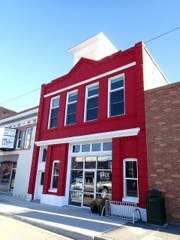 | Big Timber Town Hall | building | 1998 | 98000125 |
| Brannin Ranch | district | 1989 | 88003142 | |
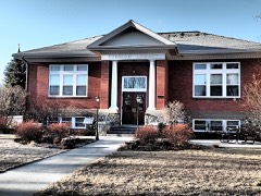 | Carnegie Public Library | building | 2002 | 02000725 |
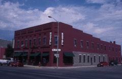 | Grand Hotel | building | 1985 | 85002424 |
| Harrison, Waborn (Wabe) and Sarah E., Ranch House | building | 1998 | 98001111 | |
| John Otto Spannring Family Farm | district | 1995 | 95000145 | |
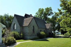 | St. Mark's Episcopal Church | building | 1995 | 95000900 |
| Yellowstone Crossing, Bozeman Trail | site | 1978 | 78003407 |
Every wildfire the federal occurrence database records inside this county: 205 of them, burning about 291,036 acres. 102 started naturally and 1 was recorded as arson. Each settlement page carries the fires within five miles of it.
| Reported cause | Fires |
|---|---|
| Natural | 102 |
| Missing data/not specified/undetermined | 67 |
| Recreation and ceremony | 10 |
| Equipment and vehicle use | 8 |
| Debris and open burning | 6 |
| Misuse of fire by a minor | 3 |
| Power generation/transmission/distribution | 3 |
| Fireworks | 3 |
| Smoking | 1 |
| Railroad operations and maintenance | 1 |
| Arson/incendiarism | 1 |
The five largest, by the area the report gives. None of them was recorded as arson.
| Date | Cause | Size | Reported by | Name on the report |
|---|---|---|---|---|
| 22 August 2006 | Natural | 207,115 acres | Custer Gallatin National Forest | DERBY |
| 8 August 2003 | Natural | 36,180 acres | Southern Land Office | HOBBLE FIRE |
| 12 November 2007 | Recreation and ceremony | 17,954 acres | Southern Land Office | CHI CHI |
| 8 September 1994 | Natural | 12,500 acres | Custer Gallatin National Forest | BLACK BUTTE |
| 16 December 1999 | Power generation/transmission/distribution | 4,400 acres | Southern Land Office | CHRISTMAS |
| 11 August 2001 | Natural | 2,560 acres | Custer Gallatin National Forest | MONUMENT |
| 26 July 2015 | Natural | 1,500 acres | Billings Field Office | BEAVER FIRE |
| 26 August 2017 | Missing data/not specified/undetermined | 1,275 acres | Billings Field Office | MENDONHALL |
Every settlement page carries the fires within five miles of it - see the settlement index below.
The NOAA Storm Events Database holds 188 reports for this county, causing no deaths, no injuries and about $4,500,030 in recorded property damage. Each settlement page carries the reports that name it.
| Kind of event | Reports |
|---|---|
| Hail | 130 |
| Thunderstorm Wind | 37 |
| Flood | 5 |
| Flash Flood | 5 |
| Heavy Rain | 5 |
| Tornado | 2 |
| Wildfire | 2 |
| Funnel Cloud | 2 |
The most serious of them, by death, then injury, then recorded damage. The accounts are quoted exactly as the forecast office filed them.
| When | Event | Place named | Harm | What the report says |
|---|---|---|---|---|
| May 2011 | Flood | Melville | $4,000,000 | Significant flooding occurred on creeks and streams across Sweet Grass County resulting in widespread lowland flooding and numerous county roads flooded, closing roads and resulting in significant damage. Numerous bridges also washed out. Specifically, Upper Deer, Lower Deer, Bridger, Sweet Grass, Big Timber and Otter Creeks Flooded. Specific roads flooded include; Anderson, Lower Sweet Grass, Mendinhaul, and Windsor Loop. At the height of the flooding, water was overtopping Interstate 90 from Mile Post 376 to 377. Damage estimates based on FEMA reviews and Individual Assistance approvals. |
| July 1994 | Thunderstorm Wind | Big Timber | $500,000 | Many trees and powerlines down north, east and south of Big Timber. |
| May 1973 | Tornado (F0) | not stated | $30 | no account filed |
| June 2025 | Hail | Melville | - | One and a quarter inch hail reported. |
| July 2025 | Thunderstorm Wind | Big Timber | - | Mesonet station gw0007 near Big Timber. |
| June 2025 | Hail | Big Timber | - | Hail report. |
| June 2023 | Flash Flood | Greycliff | - | A thunderstorm 8 to 10 miles north/northwest of Reed Point produced heavy rainfall resulting in flash flooding that affected West White Beaver Creek. The flash flood created some log jams and took out some fencing. |
| June 2023 | Flash Flood | Greycliff | - | Water was reported over the roads along with an inch accumulation of pea size hail. |
| July 2022 | Flood | Big Timber | - | Minor street flooding reported by broadcast media. |
| June 2014 | Hail | Melville | - | Hail accumulated to 2 inches on the ground and was accompanied by 40 to 50 mph winds. |
| March 2014 | Flood | Melville | - | County officials and the Montana Department of Transportation reported that small stream and low land flooding occurred across the area. Water was reported to be flowing over Highway 12 near Two Dot and Highway 191 between Harlowton and Judith Gap. Water also flowed across some of the roads along the Beartooth Foothills south of Reed Point and Columbus. |
| March 2014 | Flood | Greycliff | - | County officials reported that some streams and creeks were running high, and in some areas, water was running over roadways and flooding fields. Some roads became impassable. |
| July 2014 | Thunderstorm Wind | Mc Leod | - | Four to five large Cottonwood trees were downed. |
| June 2013 | Funnel Cloud | Big Timber | - | A funnel cloud was reported over the Big Timber Airport. |
| July 2013 | Thunderstorm Wind | Greycliff | - | Winds were estimated at 75 mph. |
| June 2013 | Hail | Big Timber Arpt | - | The hail was accompanied by 50 to 60 mph winds. |
| June 2013 | Thunderstorm Wind | Big Timber Arpt | - | Wind gusts estimated at 60 mph were reported. |
| June 2013 | Thunderstorm Wind | Greycliff | - | Wind gusts were estimated at 60 mph. |
| June 2013 | Thunderstorm Wind | Big Timber Arpt | - | Wind gusts of 50 to 60 mph were estimated. |
| June 2013 | Flash Flood | Big Timber | - | A mudslide was reported just north of Big Timber on Highway 191. There were additional reports of flash flooding from Big Timber to Melville. |
| June 2013 | Thunderstorm Wind | Greycliff | - | Cottonwood tree branches of 2 to 3 inches in diameter were broken. |
| September 2013 | Thunderstorm Wind | Melville | - | A wind gust of 60 mph was estimated 20 miles northeast of Big Timber. |
| September 2013 | Thunderstorm Wind | Melville | - | A wind gust of 70 mph was estimated 12 miles west/northwest of Rapelje. |
| August 2013 | Hail | Big Timber | - | The winds were estimated at 60 mph. The hail and wind combination broke skylights and windows. |
| June 2011 | Funnel Cloud | Greycliff | - | A funnel cloud was spotted between Greycliff and Big Timber. |
| August 2011 | Thunderstorm Wind | Melville | - | An estimated wind gust of 65 mph was reported 12 miles WNW of Rapelje. |
| June 2010 | Thunderstorm Wind | Melville | - | An estimated thunderstorm wind gust of 60 mph was estimated 11 miles north of Big Timber. |
| June 2010 | Hail | Big Timber | - | Damage from hail resulted in windows being knocked out of a two-story house, as well as a broken vehicle windshield. |
| June 2010 | Thunderstorm Wind | Melville | - | An estimated wind gust of 60 mph was reported 11 miles north of Big Timber. |
| July 2010 | Thunderstorm Wind | Big Timber Arpt | - | Winds caused two dirt devils in pastures plus the laying over of large trees. Sustained winds were estimated at 50 mph. |
| July 2010 | Hail | Melville | - | Hail size ranged from peas to nickels to quarters. |
| May 2007 | Hail | Big Timber | - | Soft hail with heavy rain and light winds were reported. |
| July 2006 | Thunderstorm Wind | Big Timber | - | 3 inch diameter Willow branches down. 30 foot dead Cottonwood tree also knocked down. |
| July 2006 | Hail | Greycliff | - | Pea size hail covering the ground and heavy rain. |
| May 2005 | Heavy Rain | Melville | - | 1.40 inches of rain 4W Melville (24-hour total) |
| May 2005 | Heavy Rain | Melville | - | 2.87 inches of rain 4W Melville (24-hour total) |
| May 2005 | Heavy Rain | Big Timber | - | 2.80 inches of rain 6S Big Timber (24-hour total) |
| May 2005 | Heavy Rain | Melville | - | 1.10 inches of rain in 12 hours |
| June 2004 | Flash Flood | Melville | - | Flash flooding was observed on Otter Creek between 5 pm and 7pm with some damage to fences and bridges. Some flooding was also observed on Sweet Grass Creek. |
| July 2001 | Hail | Greycliff | - | Hail completely covered the ground |
| August 1999 | Hail | Big Timber | - | Spotter report of dime size hail. |
| July 1998 | Hail | Mc Leod | - | A coop observer reported half dollar sized hail. |
| July 1998 | Heavy Rain | Greycliff | - | A spotter reported 2.60 inches of rainfall in one hour. |
| July 1995 | Hail | not stated | - | Cars were dented, windshields broken, and house windows broken by golf ball size hail. |
| July 1995 | Hail | Wibaux | - | Cars were dented, windshields broken, and house windows broken by golf ball size hail. |
| July 1995 | Hail | Nr Big Timber | - | Cars were dented, windshields broken, and house windows broken by golf ball size hail. |
| July 1995 | Hail | Big Timber | - | Cars were dented, windshields broken, and house windows broken by golf ball size hail. |
| July 2024 | Thunderstorm Wind | Big Timber Arpt | - | no account filed |
| June 2024 | Thunderstorm Wind | Big Timber Arpt | - | no account filed |
| June 2024 | Thunderstorm Wind | Big Timber Arpt | - | no account filed |
| August 2023 | Thunderstorm Wind | Melville | - | no account filed |
| August 2022 | Thunderstorm Wind | Big Timber Arpt | - | no account filed |
| July 2022 | Hail | Big Timber | - | no account filed |
| September 2022 | Thunderstorm Wind | Big Timber | - | no account filed |
| July 2021 | Thunderstorm Wind | Big Timber Arpt | - | no account filed |
| July 2021 | Thunderstorm Wind | Melville | - | no account filed |
| July 2021 | Thunderstorm Wind | Big Timber Arpt | - | no account filed |
| June 2020 | Thunderstorm Wind | Big Timber Arpt | - | no account filed |
| May 2020 | Hail | Melville | - | no account filed |
| May 2020 | Hail | Greycliff | - | no account filed |
The Survey's mineral resources record lists 151 workings inside this county. 3 still produce and 148 are closed or unrecorded. Each settlement page carries the workings within five miles of it.
| Commodity | Workings |
|---|---|
| Gold | 50 |
| Chromium | 29 |
| Silver | 21 |
| Calcium | 12 |
| Platinum | 10 |
| Platinum, Palladium, Rhodium | 10 |
| Nickel, Copper | 10 |
| Copper, Nickel | 8 |
| Nickel | 7 |
| Copper | 7 |
| PGE, Silver, Gold | 6 |
| Cobalt | 5 |
| Gold, Copper, Nickel | 5 |
| PGE | 4 |
The least common of them first, because a county's hundredth gravel pit says nothing its first ten did not.
| Where | Site | Commodity | Status | Recorded |
|---|---|---|---|---|
| Alaskite | Platinum, Palladium, Copper, Nickel, Chromium | Occurrence | Chromite | |
| Anderson's Springs | Geothermal | Producer | ||
| Bluebird Cr-Pt | Platinum, Chromium, Copper, Nickel | Occurrence | ||
| Bluebird Ni-Cu | Nickel, Copper, Cobalt, Palladium, Platinum, PGE, Silver, Gold | Occurrence | Chalcopyrite, Pentlandite, Pyrrhotite | |
| Boulder Creek Mine | Palladium, Platinum, PGE, Gold, Nickel, Copper | Producer | PGE Reef | |
| Boulder River Ni-Cu East | Copper, Nickel, Cobalt, Gold, Silver, PGE | Occurrence | Chalcopyrite, Pentlandite, Pyrrhotite | |
| Boulder River Nickel Prospect | Nickel, Cobalt, Copper, Gold, Silver | Prospect | ||
| Chrome Mountain Ni-Cu | Copper, Nickel, Cobalt, Platinum, Palladium, Rhodium, Silver, Gold, PGE | Occurrence | Chalcopyrite, Pentlandite, Pyrrhotite | |
| Crescent Creek Cr-Pt | Platinum, Chromium, Copper, Nickel, Palladium, Rhodium | Occurrence | Chromite | |
| Crescent Creek Ni-Cu | Nickel, Copper, Cobalt, Palladium, Rhodium, Platinum, PGE, Silver, Gold | Occurrence | 1932 | |
| Forge Ni-Cu | Copper, Nickel, Rhodium, Palladium, Platinum, Cobalt, PGE, Gold, Silver | Occurrence | 1932 | |
| Frog Pond East | Platinum, Palladium, Rhodium, Copper, Nickel, Gold | Occurrence | ||
| Half Moon Mine | Lead, Gold, Silver | Prospect | Vein | |
| Half Moon Mine | Gold, Lead, Silver | Occurrence | ||
| Initial Cr-Pt | Platinum, Chromium, Nickel, Copper | Occurrence | 1941 | |
| Iron Mountain Ni-Cu Camp | Nickel, Copper, Rhodium, Cobalt, Platinum, Palladium, PGE, Silver, Gold | Occurrence | Chalcopyrite, Pentlandite, Pyrrhotite | |
| Iron Mountain-Camp Ni-Cu Deposit | Nickel, Copper, Cobalt, Sulfur | Prospect | 1968 | |
| Iron Mountain-Gold Hill Area | Gold, Silver, Iron | Prospect | ||
| Janet 50 | Zinc, Gold, Arsenic, Copper, Nickel, Platinum, Palladium, Lead | Occurrence | 1967 | |
| Knapp Mine | Iron, Copper | Prospect | ||
| Majestic & Flora B Claims | Palladium, Platinum, Copper, Nickel | Occurrence | ||
| Monkey East Camp Zone | Platinum, Palladium, Rhodium, Gold, Nickel, Copper | Occurrence | Chalcopyrite, Pentlandite, Pyrite, Pyrrhotite | |
| Picket Pin | Platinum, Palladium, Copper, Nickel, Cobalt, Iridium, Gold, Arsenic, Antimony | Occurrence | 1936 | |
| Pine Claim | Gold, Silver, Chromium | Prospect | ||
| Skyline Prospect | Lead, Silver, Gold | Past Producer | Galena | |
| Stillwater Anorthosite | Aluminum, Silica, Magnesite, Iron, Calcium, Sodium | Prospect | 1916 | |
| Boulder River Ni-Cu Riverside | Nickel, Copper, Cobalt, PGE, Gold, Silver | Occurrence | Chalcopyrite, Pentlandite, Pyrrhotite | |
| Coors 602 | Platinum, Palladium, Copper, Nickel | Occurrence | 1967 | |
| North Star | Silver, Lead, Copper | Prospect | ||
| Omega Lode | Gold, Lead, Copper | Prospect | ||
| Poorman No. 2 Lode | Lead, Zinc | Prospect | ||
| Unnamed Gravel Pit | Sand and Gravel, Construction | Producer | ||
| Unnamed Gravel Pit | Sand and Gravel, Construction | Unknown | ||
| West Fork Cr-Pt Tuttle | Platinum, Chromium, Copper, Nickel | Occurrence | ||
| Yellowjacket No. 2 Lode | Lead, Zinc | Prospect | ||
| Bluebird | Chromium, Rhodium, Palladium, Platinum | Occurrence | 1939 | |
| Crown Lode | Copper, Zinc, Lead | Prospect | ||
| East Rainbow | Gold, Silver | Occurrence | ||
| Lilliput Fraction 221 | Gold, Zinc, Lead | Prospect | ||
| Rainbow | Gold, Silver | Occurrence | ||
| Skylark | Silver, Zinc, Lead | Prospect | ||
| Unidentified Occurrence | Gold, Silver | Occurrence | ||
| West Fork East Adit | Rhodium, Palladium, Platinum, Gold, Nickel, Copper | Occurrence | 1967 | |
| West Fork G Taylor-Fry | Chromium, Rhodium, Palladium, Platinum | Occurrence | 1919 | |
| Big Group Claims | Iron | Prospect | ||
| Blakely Cliffs | Chromium, PGE | Occurrence | Chromite | |
| Brilliant | Gold, Lead | Prospect | ||
| Butte and Butte No. 1 Claims | Iron | Unknown | ||
| Deer Creek | Iron | Prospect | ||
| Iron Dike | Iron | Prospect | ||
| Iron Mountain-Chrome Group E | Chromium, PGE | Occurrence | ||
| Iron Mountain-Chrome Group W | Chromium, PGE | Occurrence | 1940 | |
| Picket Pin | PGE | Prospect | ||
| Ski Line Mine | Lead, Silver | Past Producer | 1941 | |
| Boulder East | Platinum, Palladium, Rhodium, Gold, Copper, Nickel | Occurrence | ||
| Boulder West | Platinum, Palladium, Rhodium, Gold, Copper, Nickel | Occurrence | ||
| Crescent Peak Ni-Cu | Nickel, Copper, Cobalt, PGE, Silver, Gold | Occurrence | Chalcopyrite, Pentlandite, Pyrrhotite | |
| Dow | Platinum, Palladium, Rhodium, Gold, Copper, Nickel | Occurrence | ||
| Frog Pond West | Platinum, Palladium, Rhodium, Gold, Copper, Nickel | Occurrence | Chalcopyrite, Pentlandite, Pyrite, Pyrrhotite | |
| Intial Ni-Cu | Nickel, Copper, Cobalt, PGE, Silver, Gold | Occurrence | 1883 | |
| Iron Mountain Ni-Cu Iron Creek | Nickel, Copper, Cobalt, PGE, Silver, Gold | Occurrence | Chalcopyrite, Pentlandite, Pyrrhotite | |
| Monkey West | Platinum, Palladium, Rhodium, Gold, Copper, Nickel | Occurrence | ||
| Crescent Creek Ni/Cu | Nickel, Copper | Prospect | ||
| Eve Group | Copper, Nickel | Prospect | ||
| Iron Creek | Nickel, Copper | Prospect | ||
| Majestic and Flora B Claims | Platinum, Nickel | Prospect | ||
| Poorman Lode | Gold, Copper | Prospect | ||
| Unnamed Copper Mine | Copper | Unknown | ||
| Unnamed Copper Occurrence | Copper | Occurrence | ||
| Whittaker Property | Nickel, Platinum | Prospect | ||
| West Fork West | Platinum, Palladium, Rhodium, Gold, Copper, Nickel | Occurrence | ||
| Bluebird | Chromium, Platinum | Occurrence | ||
| East Boulder Plateau | Chromium, Platinum, Palladium, Rhodium | Occurrence | 1940 | |
| East Boulder Plateau | Chromium, Platinum | Prospect | ||
| East Boulder River | Chromium, Platinum | Occurrence | ||
| East Boulder River-Chrome Queen | Chromium, Platinum | Occurrence | 1940 | |
| Gish Mine | Chromium, Platinum, Palladium, Rhodium | Occurrence | 1918 | |
| Gish Mine | Chromium, Nickel, Copper | Past Producer | 1918 | |
| Initial | Chromium, Platinum | Prospect | ||
| Iron Mountain Chrome Group | Chromium, Platinum | Prospect | ||
| Taylor-Fry-Tuttle | Chromium, Platinum | Prospect | ||
| Ayers Property | Calcium | Occurrence | ||
| Boulder Calcite | Calcium | Unknown | ||
| Bridger Creek | Calcium | Occurrence | ||
| Cartwright Calcite Deposit | Calcium | Past Producer | ||
| Cartwright Crystal Spar Group | Calcium | Prospect | ||
| Curry Calcite Deposit | Calcium | Occurrence | ||
| Fox | Calcium | Occurrence | ||
| Smith Homestead | Calcium | Unknown | ||
| Ueland Calcite Deposit | Calcium | Occurrence | ||
| Unnamed Calcite Deposit | Calcium | Occurrence | ||
| Unnamed Calcite Deposit | Calcium | Occurrence | ||
| Unnamed Calcite Deposit | Calcium | Occurrence | ||
| Accident | Gold, Silver | Prospect | ||
| Clara | Gold, Silver | Prospect | ||
| Dixie | Silver | Prospect | ||
| Eve Group Moonlight Group | Silver | Prospect | ||
| Hidden Treasure Mine | Gold, Silver | Past Producer | Vein | |
| Hidden Treasure No. 4 | Gold, Silver | Prospect | ||
| Independence A | Silver, Gold | Prospect | ||
| Independence Mine | Gold, Silver | Past Producer | 1814 | |
| Midnight Bell | Gold, Silver | Occurrence | ||
| Omega | Gold, Silver | Prospect | ||
| Placer and Placer | Gold, Silver | Past Producer | ||
| Poor Man | Gold, Silver | Prospect | ||
| Ross Mine | Gold, Silver | Occurrence | ||
| Silver King Mine | Silver, Gold | Unknown | ||
| Springfield | Silver | Prospect | ||
| Surprise Mine | Gold, Silver | Occurrence | ||
| Tam and Zana | Silver | Prospect | ||
| Unnamed Prospect | Gold, Silver | Prospect | ||
| Blakely Cliff Deposit | Chromium | Occurrence | ||
| Bluebird Fraction | Chromium | Prospect | Vein | |
| Bonanza No. 1 Lode | Chromium | Prospect | Vein | |
| Bonanza No. 3 Lode | Chromium | Prospect | Vein | |
| Bonanza No. 4 Lode | Chromium | Prospect | Vein | |
| Bonanza No. 5 Lode | Chromium | Prospect | Vein | |
| Dark Horse | Chromium | Prospect | Chromite | |
| Ground Hog | Chromium | Past Producer | ||
| Lost Shaft | Chromium | Prospect | Vein | |
| M & R No. 1 | Chromium | Prospect | Chromite | |
| M & R No. 2 | Chromium | Occurrence | Vein | |
| M & R No. 3 | Chromium | Prospect | Vein | |
| M & R No. 4 | Chromium | Prospect | Vein | |
| M & R No. 5 | Chromium | Prospect | Vein | |
| Annie | Gold | Prospect | ||
| Blue Lake Prospects | Gold | Prospect | ||
| Columbus | Gold | Prospect | ||
| Crown | Gold | Prospect | ||
| Cumberland | Gold | Prospect | ||
| Daisy | Gold | Past Producer | ||
| Daisy Group | Gold | Past Producer | 1894 | |
| Delta | Gold | Prospect | ||
| Delta Lode | Gold | Prospect | ||
| East Rainbow | Gold | Prospect | ||
| Emma | Gold | Prospect | ||
| Gold Hill Mine | Gold | Occurrence | ||
| Golden Slipper | Gold | Prospect | ||
| Haystack Peak Prospect | Gold | Prospect | ||
| Hidden Treasure | Gold | Prospect | ||
| Ida B | Gold | Prospect | ||
| Independence Mine | Gold | Prospect | ||
| Kelly Prospect | Gold | Occurrence | ||
| Mud Lake Prospects | Gold | Prospect | ||
| Poor Man No. 2 | Gold | Prospect | ||
| Queen Victory | Gold | Prospect | ||
| Rainbow | Gold | Prospect | ||
| Seneca | Gold | Prospect | ||
| Swamp Lake Area | Gold | Prospect | ||
| Wheelon | Gold | Prospect | ||
| Yellowjacket No. 2 | Gold | Prospect |
Named settlements recorded in the Geographic Names Information System, each with the topographic sheets covering it. Villages, hamlets and abandoned places alike. Each is shown with the nearest named watercourse or landform and the survey quadrangle it falls on.
South of the Yellowstone census division · 59011 · On Pig Creek · Big Timber quadrangle
16 sheets, 1891 to 1979
South of the Yellowstone census division · 59011 · On Fryer Creek · Carney quadrangle
16 sheets, 1891 to 1992
South of the Yellowstone census division · 59033 · Near Dillon Gulch · Greycliff quadrangle
16 sheets, 1891 to 1979
North of the Yellowstone census division · 59011 · Locomotive Butte SW quadrangle
11 sheets, 1889 to 1993
South of the Yellowstone census division · 59052 · On West Boulder River · McLeod quadrangle
19 sheets, 1891 to 2000
North of the Yellowstone census division · 59055 · Melville quadrangle
11 sheets, 1889 to 1993
North of the Yellowstone census division · 59055 · On Billy Creek · Melville quadrangle
11 sheets, 1889 to 1993
No longer a settlement
South of the Yellowstone census division · 59033 · On Bridger Creek · Work Creek quadrangle
16 sheets, 1891 to 1979
North of the Yellowstone census division · 59011 · On Henry Creek · Kelly Hills quadrangle
17 sheets, 1891 to 1992
North of the Yellowstone census division · 59011 · Ryan Creek quadrangle
15 sheets, 1891 to 1979
North of the Yellowstone census division · 59011 · Otter Creek School quadrangle
18 sheets, 1891 to 1992
No longer a settlement
The vanished settlements of Sweet Grass County: the places named above that are no longer on the map.