 Block
From the record
6 National Register listings published here.
Sources: the National Register database, National Park Service
48 topographic sheets cover 21 settlements here, and 6 properties are on the National Register of Historic Places.
6 National Register listings published here.
Sources: the National Register database, National Park Service
Every property in this county listed on the National Register of Historic Places, with the year it was listed and the federal nomination document.
| Photograph | Property | Type | Listed | Reference |
|---|---|---|---|---|
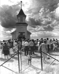 | Bethany Lutheran Church | building | 1993 | 93001375 |
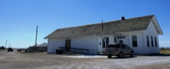 | Kevin Depot | building | 1980 | 80002433 |
| Marias River Bridge | structure | 2012 | 12000173 | |
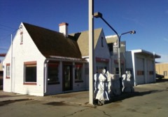 | Rainbow Conoco | building | 1994 | 94000866 |
| Shelby Town Hall | building | 2006 | 06000040 | |
| US Customs Building | building | 1991 | 91000152 |
Every wildfire the federal occurrence database records inside this county: 75 of them, burning about 882 acres. 5 started naturally and none was recorded as arson. Each settlement page carries the fires within five miles of it.
| Reported cause | Fires |
|---|---|
| Equipment and vehicle use | 29 |
| Missing data/not specified/undetermined | 17 |
| Debris and open burning | 6 |
| Power generation/transmission/distribution | 5 |
| Natural | 5 |
| Railroad operations and maintenance | 4 |
| Smoking | 4 |
| Fireworks | 2 |
| Recreation and ceremony | 1 |
| Other causes | 1 |
| Misuse of fire by a minor | 1 |
The five largest, by the area the report gives. None of them was recorded as arson.
| Date | Cause | Size | Reported by | Name on the report |
|---|---|---|---|---|
| 26 August 2017 | Equipment and vehicle use | 200 acres | Central Land Office | not named |
| 30 September 2020 | Equipment and vehicle use | 150 acres | Toole County | TOMSHX INC |
| 25 August 2020 | Equipment and vehicle use | 100 acres | Toole County | KW FIRE |
| 4 November 2018 | Recreation and ceremony | 65 acres | Central Land Office | not named |
| 8 December 2017 | Smoking | 50 acres | Central Land Office | not named |
| 26 July 2020 | Equipment and vehicle use | 45 acres | Toole County | MONROE |
| 7 July 2018 | Equipment and vehicle use | 35 acres | Central Land Office | not named |
| 17 August 2018 | Railroad operations and maintenance | 25 acres | Central Land Office | not named |
Every settlement page carries the fires within five miles of it - see the settlement index below.
The NOAA Storm Events Database holds 143 reports for this county, causing no deaths, no injuries and about $48,030 in recorded property damage. Each settlement page carries the reports that name it.
| Kind of event | Reports |
|---|---|
| Thunderstorm Wind | 66 |
| Hail | 58 |
| Tornado | 6 |
| Flash Flood | 5 |
| Heavy Rain | 5 |
| Flood | 2 |
| Funnel Cloud | 1 |
The most serious of them, by death, then injury, then recorded damage. The accounts are quoted exactly as the forecast office filed them.
| When | Event | Place named | Harm | What the report says |
|---|---|---|---|---|
| June 2000 | Thunderstorm Wind | Shelby | $15,000 | 1.5 inch hail...gust to 60kt...roof/siding damage to homes...wind damage to shed. |
| July 1998 | Flash Flood | Shelby | $10,000 | no account filed |
| July 1994 | Thunderstorm Wind | Shelby | $5,000 | no account filed |
| July 1994 | Hail | Ethridge | $5,000 | no account filed |
| May 1993 | Thunderstorm Wind | Conrad | $5,000 | no account filed |
| June 1991 | Tornado (F0) | not stated | $2,500 | no account filed |
| May 1982 | Tornado (F2) | not stated | $2,500 | no account filed |
| June 2000 | Thunderstorm Wind | Shelby | $2,000 | 1.5 inch hail...gust to 52kt. |
| June 1995 | Thunderstorm Wind | Of Shelby | $1,000 | A wind gust to 124 mph was recorded at the Hillside Hutterite Colony. The winds toppled an empty grain bin. The exact time and location have been estimated. |
| May 1982 | Tornado (F0) | not stated | $30 | no account filed |
| July 2025 | Thunderstorm Wind | Sweetgrass Ross Arpt | - | Ambient Weather station in Sweet Grass measured a 61 mph gust. |
| July 2025 | Hail | Sunburst Arpt | - | One inch hail reported from mPING. |
| July 2025 | Thunderstorm Wind | Devon | - | Mesonet station GW5346 Devon Three West measured a 59 mph wind gust. |
| August 2025 | Thunderstorm Wind | Galata | - | Bootlegger S CG SW Mesonet peak gust. |
| August 2024 | Thunderstorm Wind | Ethrdg Torgerson Arp | - | Mesonet station GW1987 Ethridge 3 SE measured a severe caliber gust. |
| August 2024 | Thunderstorm Wind | Sweetgrass Ross Arpt | - | Mesonet station MTWST Sweetgrass DOT sensor measured a sever caliber gust. |
| June 2022 | Heavy Rain | Kevin | - | Dw0975 Kevin. |
| June 2022 | Heavy Rain | Shelby Arpt | - | Gw0664 Shelby Airport. |
| August 2022 | Hail | Shelby Arpt | - | Pictures were received from a farmer in Toole county showing numerous nickel to quarter sized hail stones. |
| September 2022 | Thunderstorm Wind | Sunburst | - | Mesonet station MTSUN (Sunburst) reported 50 knot wind gust. |
| September 2022 | Thunderstorm Wind | Sweetgrass Ross Arpt | - | Mesonet station MTSWT Sweetgrass reported 50 knot wind gust. |
| September 2022 | Thunderstorm Wind | Kippen | - | Trained spotter reported a 73 mph wind gust. Time estimated via radar. |
| September 2022 | Thunderstorm Wind | Kippen | - | Ambient weather station E of Kippen reported 70 knot wind gust. |
| September 2022 | Thunderstorm Wind | Sunburst | - | Mesonet station FW8513 Sunburst reported 59 knot wind gust. |
| September 2022 | Thunderstorm Wind | Kippen | - | Mesonet station GW0659 Grassy Butte 2SE reported 59 knot wind gust. |
| July 2022 | Hail | Shelby Arpt | - | Trained spotter reported golf ball sized hail (1.75 inch) near Welker Farms, just NE of Shelby. Damaged crops. |
| June 2022 | Thunderstorm Wind | Hellinger | - | Mesonet station gw0799 Galata 12 NNE. |
| June 2022 | Thunderstorm Wind | Shelby Arpt | - | Gust measured at Shelby Airport. |
| June 2022 | Thunderstorm Wind | Shelby Arpt | - | Gust measured via an Ambient sensor. |
| June 2022 | Thunderstorm Wind | Hellinger | - | Measured via an Ambient sensor. |
| July 2022 | Hail | Naismith | - | Trained spotter reported 1 inch hail over a 30 minute period 12 miles E of Ledger. |
| July 2022 | Hail | Kippen | - | Trained spotter reported up to quarter sized hail (1 inch) 9 miles E of Ferdig. |
| June 2022 | Thunderstorm Wind | Kippen | - | Gust measured via an Ambient sensor. |
| July 2022 | Thunderstorm Wind | Kevin | - | Mesonet station DW0975 near Kevin measured 58 mph wind gust. |
| July 2021 | Thunderstorm Wind | Galata | - | Mesonet station at 10 NNE Galata measured a 56 kt (64 mph) thunderstorm wind gust. |
| July 2021 | Thunderstorm Wind | Shelby Arpt | - | Toole County Airport measured a 52 kt (60 mph) thunderstorm wind gust. |
| July 2021 | Thunderstorm Wind | Galata | - | Measured by ambient weather station. |
| April 2018 | Flood | Dunkirk | - | KRTV reported a high water rescue along US-2 near Dunkirk. Exact location unknown, but rescue occurred around 12 AM MDT on April 19th. Good Samaritan rescued woman from her car after it became stranded in floodwaters. |
| June 2018 | Flash Flood | Shelby | - | Facebook video of flash flooding at and near the US-2/I-15 interchange in Shelby. Some cars stalled in the floodwater. |
| June 2018 | Thunderstorm Wind | Sunburst | - | MT DOT sensor 6-miles NNW of Sunburst reported 62-mph peak gust from thunderstorm. |
| June 2017 | Hail | Ethridge | - | Public report of quarter sized hail south of Ethridge near Potter Road. |
| June 2017 | Thunderstorm Wind | Shelby Arpt | - | Trained spotter reported 2 semis and 1 camper blown over along I-15 north of Shelby. |
| June 2017 | Thunderstorm Wind | Sunburst | - | Sunburst DOT sensor recorded a gust of 83 mph. |
| June 2017 | Thunderstorm Wind | Shelby | - | Trained spotter reported a severe wind gust that caused sheet metal to wrap around pole. |
| June 2017 | Thunderstorm Wind | Shelby Arpt | - | Law Enforcement reported a double semi-trailer blown over at Mile Marker 358 along Interstate 15. |
| June 2017 | Thunderstorm Wind | Hellinger | - | Mesonet station reported 75 mph wind gust. |
| June 2017 | Thunderstorm Wind | Kippen | - | Mesonet station reported severe wind gust of 58 mph. |
| June 2017 | Thunderstorm Wind | Hellinger | - | Mesonet site reported a measured thunderstorm wind gust of 58 mph. |
| June 2017 | Thunderstorm Wind | Oilmont | - | Trained spotter reported severe wind gust of 62 mph via social media. |
| June 2017 | Thunderstorm Wind | Sunburst | - | A 115 mph thunderstorm wind gust was recorded by personal weather station. Likely associated with downburst. Damage to trees, picnic area, roof, and siding. |
| June 2017 | Thunderstorm Wind | Kevin | - | Trained spotter reported downed tree branches and a power outage. |
| August 2016 | Hail | Sunburst | - | A thunderstorm dropped 1.75 inch diameter hail at Sunburst 1NW. Also, 1 inch diameter hail fell at Sunburst 4WNW. |
| August 2016 | Hail | Sunburst | - | A thunderstorm dropped 1.25 inch diameter hail at Sunburst 16ENE. |
| July 2015 | Thunderstorm Wind | Kippen | - | Blue Herron Mesonet site reported a wind gust of 64 knots. |
| July 2015 | Hail | Ross Intl Arpt | - | The ground was covered in penny to nickel size hail. |
| August 2015 | Thunderstorm Wind | Hellinger | - | A 67 mph wind gust at the Crooked Coulee Mesonet site. |
| June 2013 | Hail | Shelby | - | Heavy rain, pea sized hail, and a few severe hailstones measuring 1.00 inches (approximately quarter sized) were reported in Shelby, MT. |
| July 2013 | Thunderstorm Wind | Devon | - | High winds measuring 58KT (67MPH) were reported 7 mi NW of Devon, MT. |
| July 2013 | Heavy Rain | Ferdig | - | Heavy rain measuring .95 inches associated with a passing thunderstorm. Winds gusted to 48KT (56MPH) with the storm. |
| August 2013 | Hail | Ethridge | - | Hail measuring 1.00 inches (quarter sized) was reported 5 miles SSW of Ethridge, MT by KSEN radio. |
The Survey's mineral resources record lists 3 workings inside this county. 1 still produces and 2 are closed or unrecorded. Each settlement page carries the workings within five miles of it.
| Commodity | Workings |
|---|---|
| Sand and Gravel, Construction | 3 |
The least common of them first, because a county's hundredth gravel pit says nothing its first ten did not.
| Where | Site | Commodity | Status | Recorded |
|---|---|---|---|---|
| B & N Portable Crusher | Sand and Gravel, Construction | Past Producer | ||
| Belzer Pit | Sand and Gravel, Construction | Past Producer | ||
| Shelby Pit and Plant | Sand and Gravel, Construction | Producer |
Named settlements recorded in the Geographic Names Information System, each with the topographic sheets covering it. Villages, hamlets and abandoned places alike. Each is shown with the nearest named watercourse or landform and the survey quadrangle it falls on.
Sunburst census division · 59454 · Near Rocky Springs Coulee · Aloe quadrangle
11 sheets, 1909 to 1984
Sunburst census division · 59484 · Fitzpatrick Lake quadrangle
11 sheets, 1909 to 1984
No longer a settlement
Sunburst census division · 59545 · Near Eclipse Gulch · Cameron Lake quadrangle
7 sheets, 1954 to 1984
Sunburst census division · 59482 · Hillside Colony quadrangle
11 sheets, 1909 to 1984
Sunburst census division · 59454 · On Alkali Flat Coulee · Kevin South quadrangle
8 sheets, 1943 to 1986
Sunburst census division · 59466 · Near Picadilly Coulee · Johannson Coulee quadrangle
8 sheets, 1943 to 1986
Sunburst census division · 59484 · Near West Butte · West Butte quadrangle
10 sheets, 1945 to 1986
No longer a settlement
Sunburst census division · 59482 · Hillside Colony quadrangle
11 sheets, 1909 to 1984
Shelby census division · 59474 · On Reservoir Coulee · Virden quadrangle
8 sheets, 1943 to 1986
The vanished settlements of Toole County: the places named above that are no longer on the map.