 Block
From the record
2 National Register listings published here.
Sources: the National Register database, National Park Service
38 topographic sheets cover 11 settlements here, and 2 properties are on the National Register of Historic Places.
2 National Register listings published here.
Sources: the National Register database, National Park Service
Every property in this county listed on the National Register of Historic Places, with the year it was listed and the federal nomination document.
| Photograph | Property | Type | Listed | Reference |
|---|---|---|---|---|
 | Graves Hotel | building | 1980 | 80002434 |
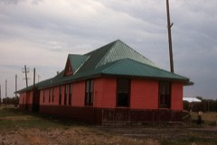 | Milwaukee Road Historic District | district | 1988 | 88001024 |
Every wildfire the federal occurrence database records inside this county: 71 of them, burning about 6,131 acres. 32 started naturally and none was recorded as arson. Each settlement page carries the fires within five miles of it.
| Reported cause | Fires |
|---|---|
| Natural | 32 |
| Missing data/not specified/undetermined | 14 |
| Equipment and vehicle use | 14 |
| Debris and open burning | 4 |
| Power generation/transmission/distribution | 3 |
| Recreation and ceremony | 3 |
| Misuse of fire by a minor | 1 |
The five largest, by the area the report gives. None of them was recorded as arson.
| Date | Cause | Size | Reported by | Name on the report |
|---|---|---|---|---|
| 1 February 2020 | Missing data/not specified/undetermined | 3,680 acres | Wheatland County | LODE ROAD |
| 23 July 2003 | Debris and open burning | 696 acres | Northeastern Land Office | not named |
| 6 August 2017 | Equipment and vehicle use | 582 acres | Northeastern Land Office | not named |
| 12 October 2020 | Power generation/transmission/distribution | 430 acres | Wheatland County | FDH-MTLG44-366 |
| 28 July 2017 | Equipment and vehicle use | 350 acres | Northeastern Land Office | not named |
| 11 January 1996 | Debris and open burning | 170 acres | Helena - Lewis and Clark National Forest | CAPSER |
| 10 March 2016 | Debris and open burning | 81 acres | Helena - Lewis and Clark National Forest | SAWMILL |
| 19 August 2020 | Missing data/not specified/undetermined | 25 acres | Wheatland County | COUNTY LODE ROAD |
Every settlement page carries the fires within five miles of it - see the settlement index below.
The NOAA Storm Events Database holds 160 reports for this county, causing no deaths, no injuries and about $5,000 in recorded property damage. Each settlement page carries the reports that name it.
| Kind of event | Reports |
|---|---|
| Hail | 107 |
| Thunderstorm Wind | 30 |
| Tornado | 7 |
| Funnel Cloud | 5 |
| Flood | 5 |
| Flash Flood | 4 |
| Heavy Rain | 2 |
The most serious of them, by death, then injury, then recorded damage. The accounts are quoted exactly as the forecast office filed them.
| When | Event | Place named | Harm | What the report says |
|---|---|---|---|---|
| June 1994 | Hail | Harlowton | $5,000 | no account filed |
| June 2025 | Hail | Harlowton | - | Two inch hail reported. |
| June 2025 | Hail | Harlowton | - | One point five inch hail reported. |
| June 2025 | Thunderstorm Wind | Harlowton | - | EM report of multiple structures with lost roofs, uprooted trees as well as tree limb damage. |
| June 2025 | Thunderstorm Wind | Harlowton | - | Corrects previous non-tstm wind dmg report from Harlowton. Power lines down with some power outages reported. |
| July 2025 | Hail | Judith Gap | - | Estimated hail by coop. |
| July 2025 | Hail | Twodot | - | Estimated by local CoCoRaHs observer. |
| July 2025 | Hail | Hedgesville | - | Reported by spotter. |
| July 2025 | Hail | Shawmut | - | Reported by spotter. |
| June 2021 | Hail | Harlowton Baxter Arp | - | Broken windows and extensive damage to siding occurred to a house. |
| July 2020 | Thunderstorm Wind | Judith Gap | - | An enhanced microburst, around the intersection of 297 and Bercail Road , with winds estimated at 70-75 mph, resulted in a swath about 2 to 3 miles of wind driven rain and hail that sheared grasses and crops. Significant crop damage occurred with grass and wheat fields sheared to the ground. In addition, numerous, large cottonwood limbs with leaves stripped were downed. A small, elevated silo was blown over and minor roof damage occurred to a couple of structures. Highway 287 had pea size to 1/2 inch size gravel blown on it from the shoulder. |
| August 2020 | Thunderstorm Wind | Shawmut | - | A wind gust of 77 mph was reported 5 miles east of Shawmut. |
| June 2019 | Tornado (EF0) | Judith Gap | - | A weak tornado touched down briefly over open areas in the foothills of the Little Belt Mountains. |
| May 2018 | Flash Flood | Shawmut | - | The public reported flash flooding along Fish Creek about 14 miles south of Shawmut. Low lying areas and creeks flooded with some roads being impassable. |
| May 2018 | Hail | Shawmut | - | There was also pea size hail 1 inch deep on the highway. |
| June 2017 | Thunderstorm Wind | Harlowton | - | Power lines and a shed were blown down in Harlowton. |
| June 2015 | Flash Flood | Twodot | - | Eight inches of rain was reported 14 miles south of Harlowton and 2 miles west of Highway 191. The heaviest rainfall impacted Lebo and American Fork Creeks. Highway 191 was closed due to high water over the roadway. Water was also reported washing over several rural county roads. |
| June 2015 | Thunderstorm Wind | Twodot | - | In addition to the strong wind gust, the ground was covered with small hail. |
| March 2014 | Flood | Winnecook | - | County officials and the Montana Department of Transportation reported that small stream and low land flooding occurred across the area. Water was reported to be flowing over Highway 12 near Two Dot and Highway 191 between Harlowton and Judith Gap. Water also flowed across some of the roads along the Beartooth Foothills south of Reed Point and Columbus. |
| March 2014 | Flood | (3ht)Harlowton | - | County officials and the Montana Department of Transportation reported significant flooding of streams and low lying areas across the area. The combination of rapid snow melt and ice resulted in high water levels along the Musselshell River from Harlowton to Shawmut...Ryegate and Lavina. In addition, some county roads were reported to be impassable. |
| June 2011 | Flood | Twodot | - | High flows along the Musselshell River from receding floodwaters from May quickly returned to flood as more heavy rainfall moved through the region. Rainfall amounts of 2 to 4 inches fell across much of Wheatland County during the 6th and 7th of June. This caused rapid water runoff and more flooding similar to what occurred in May. County officials indicated flooding occurred all along the Musselshell River. There was extensive flooding in Harlowton. Highway 12 was inundated and closed leading into Harlowton. The Musselshell River at Harlowton fluctuated above and below flood stage from the 7th through the 14th. The river crested at 8.65 feet on the 9th and 8.54 feet on the 10th. |
| June 2011 | Flood | Twodot | - | Very heavy rainfall combined with high elevation snowmelt the second half of May 2011 maintained some flooding into June along the Musselshell River. See May 2011 Storm Data publication for details regarding the significant flood impacts and damage estimates on this particular flood event. |
| May 2011 | Flood | Twodot | - | Persistent rainfall combined with snowmelt in the mountains resulted in significant flooding along the Musselshell River. The Musselshell River at Harlowton rose above flood stage from May 22nd through May 30th. The river crested at 7.47 feet on the 22nd and again on the 29th at 10.25 feet which was a record stage. In addition, the Musselshell River at Shawmut crested at a record 9.27 feet on May 26th. Extensive lowland flooding resulted along the Musselshell River as well as its tributaries. Numerous roads were closed by floodwaters with many of those eventually washing out. Flooding persisted into the month of June. Damage estimates were not available. |
| September 2010 | Tornado (EF0) | Harlowton Baxter Arp | - | A weak tornado briefly touched down 13 miles southwest of Harlowton in an open area of Southern Wheatland County during the afternoon of September 9th. The tornado did not impact any structures and no damage occurred. Therefore, the tornado was classified as an EF-0 with winds of 65-85 mph. |
| July 2009 | Thunderstorm Wind | Twodot | - | Four 8-10 inch diameter tree branches were snapped. |
| June 2007 | Hail | (3ht)Harlowton | - | Pea to golf ball size hail fell across the area. |
| June 2007 | Hail | (3ht)Harlowton | - | Golf ball to tennis ball size hail fell in Harlowton. |
| June 2007 | Hail | (3ht)Harlowton | - | Tennis ball size hail fell in Harlowton. |
| July 2007 | Thunderstorm Wind | (3ht)Harlowton | - | Winds gusted to 60 mph just south of Harlowton. |
| May 2005 | Heavy Rain | Shawmut | - | 1.25 inches of rain (24-hour total) |
| June 2005 | Funnel Cloud | Shawmut | - | Wall cloud and funnel cloud just west of Shawmut |
| June 2005 | Hail | Harlowton | - | Nickel to quarter size hail |
| August 2002 | Flash Flood | Harlowton | - | Water was running across Old Dump Road. Road closed for 2 hours. |
| May 2001 | Hail | Harlowton | - | 1.00 inch diameter hail reported near Harlowton. Some areas the hail was 2-3 inches deep. Small tree branches and leaves were stripped from the trees. |
| May 2001 | Hail | Harlowton | - | 1.00 inch diameter hail covered the ground 2 to 3 inches deep. Reported by County Emergency Management. |
| May 2001 | Hail | Twodot | - | .75 inch hail reported by spotters |
| June 2001 | Hail | Judith Gap | - | Car windows smashed in Judith Gap |
| June 2001 | Hail | Judith Gap | - | Car windows knocked out in Judith Gap |
| July 2001 | Hail | Judith Gap | - | Hail covered the ground |
| August 1999 | Hail | Living Spgs | - | Spotter report of quarter size hail. |
| August 1999 | Funnel Cloud | Harlowton | - | Wheatland sheriff dispatch reported two funnel clouds. |
| August 1999 | Tornado (F0) | Harlowton | - | A driver on U.S. Highway 191 and an amateur radio operator reported a thin rope like tornado that was on the ground over rural areas for around 15 minutes. |
| June 1999 | Hail | Judith Gap | - | Spotter report of dime size hail. |
| June 1999 | Hail | Harlowton | - | Spotter report of dime size hail. |
| June 1999 | Thunderstorm Wind | Harlowton | - | Spotter estimated 60 mph wind gust. Some power lines were downed in Harlowton and in Shawmut. |
| June 1999 | Hail | Harlowton | - | Spotter report of dime size hail. |
| August 1999 | Hail | Harlowton | - | Spotter report of dime size hail. |
| June 1999 | Hail | Shawmut | - | Wheatland County Sheriff reported dime size hail in Shawmut and 5 miles west of Ryegate. |
| July 1998 | Hail | Twodot | - | A thunderstorm produced three quarters of an inch of rain in 15 minutes in and nickel sized hail in Twodot. This same storm produced a funnel cloud just to the north of Harlowton. |
| July 1998 | Flash Flood | Harlowton | - | A slow moving thunderstorm with heavy rain produced water up to a foot deep 6 miles east of Harlowton on Highway 12. |
| August 2024 | Thunderstorm Wind | Twodot | - | no account filed |
| July 2022 | Hail | Harlowton | - | no account filed |
| July 2022 | Hail | Harlowton | - | no account filed |
| July 2022 | Hail | Harlowton | - | no account filed |
| July 2022 | Hail | Harlowton | - | no account filed |
| July 2022 | Hail | Harlowton | - | no account filed |
| July 2022 | Hail | Harlowton | - | no account filed |
| July 2022 | Thunderstorm Wind | Judith Gap | - | no account filed |
| July 2022 | Thunderstorm Wind | Twodot | - | no account filed |
| July 2022 | Thunderstorm Wind | Twodot | - | no account filed |
The Survey's mineral resources record lists 1 working inside this county. It is closed or unrecorded. Each settlement page carries the workings within five miles of it.
| Commodity | Workings |
|---|---|
| Zinc, Petroleum (Oil), Vanadium, Nickel | 1 |
The least common of them first, because a county's hundredth gravel pit says nothing its first ten did not.
| Where | Site | Commodity | Status | Recorded |
|---|---|---|---|---|
| Heath | Zinc, Petroleum (Oil), Vanadium, Nickel | Prospect | SYNGENETIC SEDIMENT-HOSTED (CARBON-RICH) |
Named settlements recorded in the Geographic Names Information System, each with the topographic sheets covering it. Villages, hamlets and abandoned places alike. Each is shown with the nearest named watercourse or landform and the survey quadrangle it falls on.
Harlowton census division · 59036 · On Jawbone Creek · Harlowton quadrangle
11 sheets, 1889 to 1993
Judith Gap-Shawmut census division · 59078 · On Roberts Creek · Hedgesville quadrangle
11 sheets, 1889 to 1993
Harlowton census division · 59036 · Jellison Place quadrangle
17 sheets, 1886 to 1995
Judith Gap-Shawmut census division · 59453 · Near Oka Coulee · Judith Gap quadrangle
12 sheets, 1889 to 1995
Judith Gap-Shawmut census division · 59453 · Nihill quadrangle
11 sheets, 1889 to 1993
Harlowton census division · 59053 · On North Fork Musselshell River · Martinsdale quadrangle
16 sheets, 1886 to 1993
Judith Gap-Shawmut census division · 59036 · Harlowton quadrangle
11 sheets, 1889 to 1993
Harlowton census division · 59085 · On Haymaker Creek · Twodot quadrangle
16 sheets, 1886 to 1993
Judith Gap-Shawmut census division · 59036 · On Timber Creek · Ethels Coulee quadrangle
11 sheets, 1889 to 1993