 Block
From the record
4 National Register listings published here.
Sources: the National Register database, National Park Service
18 topographic sheets cover 5 settlements here, and 4 properties are on the National Register of Historic Places.
4 National Register listings published here.
Sources: the National Register database, National Park Service
Every property in this county listed on the National Register of Historic Places, with the year it was listed and the federal nomination document.
| Photograph | Property | Type | Listed | Reference |
|---|---|---|---|---|
 | St. Peter's Catholic Church | building | 1990 | 90000356 |
| Vogt-Nunberg Farm | district | 2008 | 08000269 | |
 | Wibaux Commercial Historic District | district | 1989 | 89002170 |
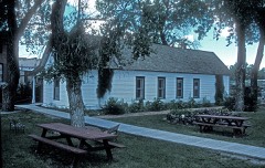 | Pierre Wibaux House | building | 1971 | 71000483 |
Every wildfire the federal occurrence database records inside this county: 53 of them, burning about 1,161 acres. 12 started naturally and none was recorded as arson. Each settlement page carries the fires within five miles of it.
| Reported cause | Fires |
|---|---|
| Equipment and vehicle use | 29 |
| Natural | 12 |
| Power generation/transmission/distribution | 5 |
| Missing data/not specified/undetermined | 5 |
| Railroad operations and maintenance | 2 |
The five largest, by the area the report gives. None of them was recorded as arson.
| Date | Cause | Size | Reported by | Name on the report |
|---|---|---|---|---|
| 1 July 2017 | Equipment and vehicle use | 220 acres | Eastern Land Office | SETERA |
| 24 October 2018 | Equipment and vehicle use | 200 acres | Eastern Land Office | PASTURE CREEK |
| 10 April 2017 | Equipment and vehicle use | 180 acres | Eastern Land Office | FELDMAN |
| 23 August 2016 | Equipment and vehicle use | 67 acres | Eastern Land Office | DUCK - MCCONE |
| 1 July 2017 | Equipment and vehicle use | 60 acres | Eastern Land Office | DOBROWSKI |
| 24 August 2019 | Natural | 51 acres | Miles City Field Office | RATTLESNAKE CREEK |
| 5 July 2017 | Equipment and vehicle use | 50 acres | Eastern Land Office | MISKE |
| 4 August 2016 | Equipment and vehicle use | 49 acres | Eastern Land Office | SACKMAN 1 - PRAIRIE |
Every settlement page carries the fires within five miles of it - see the settlement index below.
The NOAA Storm Events Database holds 242 reports for this county, causing 1 death, 2 injuries and about $579,000 in recorded property damage. Each settlement page carries the reports that name it.
| Kind of event | Reports |
|---|---|
| Hail | 126 |
| Thunderstorm Wind | 80 |
| Flood | 9 |
| Tornado | 8 |
| Flash Flood | 8 |
| Heavy Rain | 7 |
| Funnel Cloud | 2 |
| Wildfire | 1 |
| Lightning | 1 |
The most serious of them, by death, then injury, then recorded damage. The accounts are quoted exactly as the forecast office filed them.
| When | Event | Place named | Harm | What the report says |
|---|---|---|---|---|
| July 1952 | Tornado (F3) | not stated | 1 killed, 2 hurt, $250,000 | no account filed |
| July 2004 | Thunderstorm Wind | Wibaux | $100,000 | A complete barn roof was blown off and a large evergreen tree was uprooted. There was crop and property damage between Red Top East Road and Edge Hill East Road. |
| June 2002 | Hail | Wibaux | $100,000 | Hail damaged several vehicles in Wibaux. |
| August 1993 | Hail | Wibaux | $50,000 | no account filed |
| June 2002 | Flash Flood | Wibaux | $30,000 | Heavy rainfall associated with a severe thunderstorms dropped 2 to 3 inches of rainfall over the area. The bridge over Little Beaver Creek just northeast of Wibaux was damaged as rain washed away gravel near the bridge and left a gaping hole. Several area roads had water that ran across them, with one area over 100 feet wide and 8 to 12 inches deep. |
| May 1953 | Tornado | not stated | $25,000 | no account filed |
| June 2011 | Lightning | Wibaux | $20,000 | Twenty one heifers were killed when lightning struck south-southwest of Wibaux. The heifers were generally lined up along a fence line, but there were six of them that were scattered up to 75 yards away. Some of the fencing was also knocked down. There were a total of 51 heifers in the pasture. |
| July 1991 | Tornado (F0) | not stated | $2,500 | no account filed |
| August 2006 | Thunderstorm Wind | Wibaux | $1,000 | An auger was blown over and damaged. |
| August 2008 | Thunderstorm Wind | Wibaux | $500 | The wind snapped tree branches and blew steel lawn furniture across the yard. One inch of rain was also estimated. |
| June 2025 | Thunderstorm Wind | Carlyle | - | Reported at the Ash Creek MT DOT station. |
| July 2025 | Heavy Rain | Pine Hill Raws | - | The Pine Hills RAWS site (PNHM8) accumulated 1.63 inches of rain in 3 hours. |
| May 2023 | Hail | Carlyle | - | A trained spotter reported hail up to the size of quarters. |
| June 2023 | Hail | Wibaux | - | A trained spotter reported hail up to the size of quarters. |
| June 2023 | Hail | Beaver Hill Dot | - | A trained spotter reported hail up to the size of half dollars. |
| June 2023 | Heavy Rain | Carlyle | - | A trained spotter measured 1 inch of rain that fell in about 10 minutes. Hail the size of peas was reported as well. |
| July 2023 | Hail | Pine Hill Raws | - | A trained spotter reported a hailstone up to the size of a teacup within hail that was predominately the size of quarters. |
| July 2023 | Thunderstorm Wind | Pine Hill Raws | - | The Pines Hill RAWS Site (PNHM8) recorded a 65 mph thunderstorm wind gust. |
| August 2023 | Heavy Rain | Pine Hill Raws | - | The Pine Hill RAWS site (PNHM8) measured 2.45 inches of rain. |
| June 2022 | Thunderstorm Wind | Pine Hill Raws | - | The Pine Hills RAWS site (PNHM8) recorded a 58 mph thunderstorm wind gust. |
| July 2022 | Thunderstorm Wind | St Phillip | - | A trained spotter reported branches knocked off of trees. |
| July 2022 | Hail | Wibaux | - | Public reported, via Facebook, hail up to the size of quarters. |
| July 2022 | Hail | Wibaux | - | A trained spotter reported hail up to the size of quarters. |
| July 2022 | Hail | St Phillip | - | Public reported hail up to the size of quarters. |
| July 2022 | Hail | Wibaux | - | Public reported hail up to the size of quarters. |
| June 2021 | Hail | St Phillip | - | Public posted photos of, and reported ping pong ball size hail, via Facebook. |
| June 2021 | Hail | Beaver Hill Dot | - | Public reported hail up to the size of golf balls. |
| July 2021 | Thunderstorm Wind | St Phillip | - | Public reported that chained down wind break panels were destroyed. A 1,000 gallon water tank was also destroyed. Wind speed was estimated to be 80mph. |
| June 2021 | Hail | Beaver Hill Dot | - | Trained spotter estimated quarter size hail bouncing off the ground. |
| June 2021 | Hail | Beaver Hill Dot | - | Wibaux County Fire Department employee reported baseball size hail. |
| June 2021 | Hail | Beaver Hill Dot | - | Trained spotter shared their report of measured baseball size hail via Twitter. |
| May 2020 | Hail | St Phillip | - | Trained spotter reported mostly nickel sized hail with a few pieces up to size of quarters. Hail nearly coated the ground. |
| May 2020 | Thunderstorm Wind | Beaver Hill Dot | - | At the Beaver Hill I-94 DOT site (MTBVR), a wind gust of 62 mph was measured. |
| June 2020 | Hail | Beaver Hill Dot | - | Public reported quarter size hail, along with measurements of 49 mph wind gusts and 0.60 inch of rainfall. |
| July 2020 | Thunderstorm Wind | Pine Hill Raws | - | At the Pine Hills RAWS site (PNHM8), a 59 mph wind gust was recorded. Time estimated by radar. |
| July 2020 | Hail | Beaver Hill Dot | - | Trained spotter reported quarter size hail, lasting for approximately 15 minutes, as well as wind gusts up to 50 mph. |
| July 2020 | Hail | Carlyle | - | Trained spotter reported hail up to the size of ping pong balls, as well as wind gusts estimated at 50 mph. |
| July 2020 | Hail | Wibaux | - | Public reported half dollar size hail. Time estimated from radar. |
| August 2019 | Thunderstorm Wind | Wibaux | - | Trained spotter reported a 70 mph wind gust. |
| September 2019 | Thunderstorm Wind | Wibaux | - | Trained spotter reported 70 mph wind gusts, along with pea size hail and heavy rain. |
| September 2019 | Thunderstorm Wind | Wibaux | - | Trained spotter reported 60 mph wind gusts, along with nickel size hail and heavy rain. |
| September 2019 | Thunderstorm Wind | Pine Hill Raws | - | A 58 mph wind gust was measured at the Pine Hill RAWS site (PNHM8). |
| August 2017 | Hail | Wibaux | - | Brief heavy rain, along with dime to quarter sized hail, was reported. |
| July 2017 | Hail | St Phillip | - | A motorist reported quarter size hail on Montana Highway 7 approximately 10 miles south of Wibaux. The report was received via social media. |
| July 2017 | Thunderstorm Wind | St Phillip | - | A motorist reported wind gusts of approximately 60 mph on Montana Highway 7 approximately 10 miles south of Wibaux. The report was received via social media. |
| June 2016 | Hail | Wibaux | - | Public reported quarter sized hail lasting for 30 minutes. Lentil and wheat crops were damaged. Rain accumulation of 3 inches was estimated. |
| June 2016 | Hail | St Phillip | - | Trained spotter reported a few hail stones up to the size of quarters. |
| June 2016 | Hail | Wibaux | - | Trained spotter reported nickel sized hail. |
| August 2016 | Hail | Wibaux | - | Trained spotter reported quarter sized hail. |
| August 2016 | Hail | Wibaux | - | Trained spotter reported an additional storm with quarter sized hail. |
| July 2016 | Thunderstorm Wind | St Phillip | - | Trained spotter measured a 62 mph wind gust which partially blew a roof off a shed. Pea sized hail also reported. |
| July 2016 | Hail | Beaver Hill Dot | - | Public reported quarter sized hail and 50 mph wind gusts. |
| July 2016 | Hail | Wibaux | - | Trained spotter reported nickel sized hail. |
| July 2016 | Thunderstorm Wind | St Phillip | - | Trained spotter reported 60 mph wind gusts along with dime sized hail and heavy rain. |
| June 2015 | Thunderstorm Wind | Wibaux | - | Trained Spotter in the town of Wibaux estimated 60 mph wind gusts from a thunderstorm just before midnight. |
| June 2015 | Hail | Wibaux | - | Trained Spotter in the town of Wibaux reported nickel-sized hail. |
| June 2015 | Hail | Wibaux | - | Trained spotter reported half dollar sized hail and heavy rain. |
| June 2015 | Hail | Beaver Hill Dot | - | Public reported nickel-sized hail. |
| June 2015 | Hail | Beaver Hill Dot | - | Trained spotter reported mainly dime-sized hail mixed with some quarter-sized hailstones along with heavy rain. |
| July 2015 | Thunderstorm Wind | Wibaux | - | Trained spotter reported 60 mph winds. |
The Survey's mineral resources record lists 3 workings inside this county. None of them still produces: all are closed or unrecorded. Each settlement page carries the workings within five miles of it.
| Commodity | Workings |
|---|---|
| Uranium | 3 |
The least common of them first, because a county's hundredth gravel pit says nothing its first ten did not.
| Where | Site | Commodity | Status | Recorded |
|---|---|---|---|---|
| Blue Butte | Uranium | Occurrence | ||
| Unknown | Uranium | Occurrence | ||
| Unknown | Uranium | Occurrence | Sedimentary |
Named settlements recorded in the Geographic Names Information System, each with the topographic sheets covering it. Villages, hamlets and abandoned places alike. Each is shown with the nearest named watercourse or landform and the survey quadrangle it falls on.
Wibaux census division · 59353 · Odland Dam NW quadrangle
7 sheets, 1909 to 1982
No longer a settlement
Pine Hill-St. Phillips census division · 59353 · Red Top Butte quadrangle
8 sheets, 1953 to 1982
The vanished settlements of Wibaux County: the places named above that are no longer on the map.