 Block
From the record
3 National Register listings published here.
Sources: the National Register database, National Park Service
16 topographic sheets cover 6 settlements here, and 3 properties are on the National Register of Historic Places.
3 National Register listings published here.
Sources: the National Register database, National Park Service
Every property in this county listed on the National Register of Historic Places, with the year it was listed and the federal nomination document.
| Photograph | Property | Type | Listed | Reference |
|---|---|---|---|---|
 | Adams County Courthouse | building | 1985 | 85002977 |
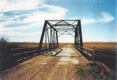 | Cedar Creek Bridge | structure | 1997 | 97000168 |
| US Post Office-Hettinger | building | 1989 | 89001751 |
Every wildfire the federal occurrence database records inside this county: 59 of them, burning about 1,718 acres. 6 started naturally and none was recorded as arson. Each settlement page carries the fires within five miles of it.
| Reported cause | Fires |
|---|---|
| Equipment and vehicle use | 33 |
| Debris and open burning | 8 |
| Natural | 6 |
| Railroad operations and maintenance | 6 |
| Missing data/not specified/undetermined | 2 |
| Smoking | 1 |
| Recreation and ceremony | 1 |
| Misuse of fire by a minor | 1 |
| Other causes | 1 |
The five largest, by the area the report gives. None of them was recorded as arson.
| Date | Cause | Size | Reported by | Name on the report |
|---|---|---|---|---|
| 1 April 2015 | Debris and open burning | 600 acres | North Dakota State Forest Service | LANDFILL FIRE |
| 23 August 2003 | Missing data/not specified/undetermined | 385 acres | North Dakota State Forest Service | REEDER |
| 21 August 2018 | Equipment and vehicle use | 140 acres | North Dakota State Forest Service | LANDIS FIRE |
| 24 February 2005 | Debris and open burning | 120 acres | South Dakota Wildland Fire Suppression | not named |
| 13 August 2015 | Equipment and vehicle use | 100 acres | North Dakota State Forest Service | NOVAK FIRE |
| 6 March 2016 | Debris and open burning | 90 acres | North Dakota State Forest Service | WOLF FIRE |
| 3 March 2015 | Equipment and vehicle use | 30 acres | North Dakota State Forest Service | RAILWAY 2 FIRE |
| 8 November 2016 | Debris and open burning | 25 acres | North Dakota State Forest Service | SKID STEER |
Every settlement page carries the fires within five miles of it - see the settlement index below.
The NOAA Storm Events Database holds 282 reports for this county, causing no deaths, 3 injuries and about $10,982,000 in recorded property damage. Each settlement page carries the reports that name it.
| Kind of event | Reports |
|---|---|
| Hail | 155 |
| Thunderstorm Wind | 102 |
| Tornado | 14 |
| Funnel Cloud | 5 |
| Flood | 3 |
| Lightning | 2 |
| Flash Flood | 1 |
The most serious of them, by death, then injury, then recorded damage. The accounts are quoted exactly as the forecast office filed them.
| When | Event | Place named | Harm | What the report says |
|---|---|---|---|---|
| July 2005 | Hail | Hettinger | 3 hurt, $7,000,000 | Golfball to baseball size hail combined with 50 mph winds caused extensive damage to homes and vehicles. One hundred (100) vehicles at an automoble dealership sustained heavy damage. Two (2) persons were treated for minor cuts, abrasions and bruises at the Hettinger hospital as a result of the hail storm. A third person sustained minor cuts when the windows of her car were broken by the hail. |
| June 2025 | Thunderstorm Wind | Hettinger | $1,000,000 | Extensive thunderstorm wind damage occurred in and around the city of Hettinger. About three miles west of Hettinger, multiple hopper-style grain bins blew over, damaging other grain bins nearby. About two miles south of Hettinger, a shop building was severely damage, with two of the four walls collapsed and the roof completely removed. Within the city of Hettinger, many campers and trailers were rolled onto their side, and multiple trees were down. Power lines were also down in various locations due to both the strong winds and trees falling on the lines. |
| June 2018 | Hail | Hettinger Arpt | $500,000 | Widespread damage was reported in and around Hettinger. A car dealership with approximately 50 vehicles sustained heavy damage. Broken windows were reported throughout town. Significant crop damage occurred around the area. |
| July 2009 | Hail | Bucyrus | $500,000 | A severe thunderstorm brought a two to three mile wide swath of very large hail across southern Adams County. The maximum hail size reported was baseball size and fell on a farm about three miles east and four miles north of Hettinger. That farm had 100 percent crop loss over 1,500 acres and had extensive damage to buildings, machinery, and vehicles. National Weather Service officials spoke with the owner of the farm who stated that every window on the west and north sides was broken. Hail broke windows on the farm house, came inside the dwelling, and broke picture frames, knickknacks, and a large screen television inside. Five sheep were beaten to death by the hail. Large hail, but smaller than baseball size, fell on the north side of Hettinger. Windows were broken and siding and roofs were damaged. Damage amounts are estimated from newspaper articles and from speaking with victims. |
| August 2021 | Hail | Haynes | $350,000 | A long lived supercell thunderstorm produced a path of destruction near Haynes. At one farm, large hail punched many holes through the metal roofs on pole barns and also into a hot-tub cover. Five vehicles were substantially damaged. Windows were broken on pole barns, and an exhaust vent for a pole barn furnace was busted off. To the south-southeast the destruction continued, with very large hail continuing to fall. In addition, strong thunderstorm winds accompanied the hail, shredding a field of lush eight foot tall corn, which was considered some of the nicest in the county, down to knee high. |
| June 1999 | Thunderstorm Wind | Hettinger | $325,000 | Producers reported a 35 to 50 percent loss of yield for 325,395 acres during the storm. |
| June 2025 | Thunderstorm Wind | Reeder | $250,000 | Two pole barn structures were severely damaged by thunderstorm wind gusts. One structure had the complete roof destroyed along with one of the walls, while the other had sections of the roof blown off and collapse. Machinery and a camper inside the structures were damaged. |
| July 2025 | Hail | Hettinger | $250,000 | Multiple vehicles were severely dented and roofs were damaged. |
| March 2009 | Flood | Reeder | $127,000 | Rapid snowmelt created overland flooding and flooding along Cedar Creek. This flooding damaged 16 homes along with county and local roads. Flooding continued into April. |
| June 2018 | Hail | Hettinger Arpt | $100,000 | Homes in the area suffered extensive damage due to the hail. |
| June 2018 | Hail | Bucyrus | $70,000 | Siding was damaged and windows were broken on a home. Roofs were damaged, along with vehicles. |
| June 2018 | Hail | Reeder | $60,000 | The hail combined with strong wind gusts to cause damage in the community of Reeder. |
| June 2009 | Hail | Hettinger | $50,000 | Quarter to golf ball size hail fell for several minutes over Hettinger. |
| April 2009 | Flood | Reeder | $42,000 | Rapid snowmelt upstream in South Dakota created a second round of overland flooding and flooding in the Cedar Creek. Additional property damages were reported. |
| May 2018 | Flash Flood | Haynes | $30,000 | Deep water covered US Highway 12 for two miles in length near the community of Haynes. |
| July 2016 | Hail | Bucyrus | $30,000 | no account filed |
| June 2018 | Hail | Haynes | $25,000 | Vehicles were damaged with many windows broken out. |
| May 2014 | Hail | Bucyrus | $25,000 | There was damage to vehicles and roofs. |
| June 2010 | Tornado (EF1) | Hettinger | $25,000 | This tornado formed just outside of the city of Hettinger, crossed Mirror Lake, where it picked up water, and came into the city on the south side. Tree branches were broken, windows were broken on an apartment building, and an automobile was damaged. The front passenger side of an automobile with two occupants was lifted off the ground a few inches and dropped back down. The occupants saw the narrow tornado spin up the street at them and then lift as it got overhead. They were shook up but no one was injured. Based on the damage done the tornado was rated low end EF1. From that it was determined that the wind speeds were around 90 mph. |
| July 2005 | Thunderstorm Wind | Reeder | $25,000 | 1/2 inch diameter hail accompanied the high wind. Trees and tree limbs down throughout Reeder. Windows broken on homes. Shed leveled and barn collapsed down to its second level. |
| May 1996 | Thunderstorm Wind | Haynes | $25,000 | no account filed |
| June 1980 | Tornado (F1) | not stated | $25,000 | no account filed |
| July 1966 | Tornado (F1) | not stated | $25,000 | no account filed |
| May 2023 | Hail | Bucyrus | $15,000 | The thunderstorm produced copious amounts of hail up to one-inch in diameter, with the hail accumulating to around two inches deep on the ground. The hail damaged the vinyl siding on a garage. |
| June 2010 | Thunderstorm Wind | Hettinger | $15,000 | The strong thunderstorm winds resulted in minor tree damage in Hettinger, along with minor damage to one home. |
| June 2016 | Hail | Hettinger | $15,000 | no account filed |
| May 1996 | Thunderstorm Wind | Lemmon | $15,000 | no account filed |
| May 2013 | Hail | Reeder | $10,000 | There was damage to buildings and automobiles. |
| July 2011 | Hail | Haynes | $10,000 | There was damage to crops and vehicles. |
| June 2007 | Flood | Hettinger | $10,000 | Heavy rain over a few day period led to water running over some county roads. Newspaper articles indicated the water was not significantly deep. Low water was running across farm roads and fields. |
| June 1998 | Lightning | Hettinger | $10,000 | The Hillcrest Care Center received damage to ovens, paging system, air conditioner control, burglar alarm, and television set. |
| October 2010 | Thunderstorm Wind | Reeder | $5,000 | Strong thunderstorm winds combined with large hail resulting in siding damage to a home. |
| July 1994 | Hail | Hettinger | $5,000 | no account filed |
| July 1994 | Thunderstorm Wind | Hettinger | $5,000 | no account filed |
| July 2020 | Thunderstorm Wind | Haynes | $3,000 | A few panels blew off a shed. |
| June 2020 | Thunderstorm Wind | Reeder | $2,000 | One inch diameter tree branches were blown down, and some shingles blew off a structure. |
| May 2024 | Thunderstorm Wind | Haynes | $1,000 | One inch diameter tree branches were broken. |
| June 2024 | Thunderstorm Wind | Haynes | $1,000 | Wind combined with one-inch diameter hail to shred leaves on trees and cause minor crop damage. See the hail entry from this location 1501-1504 MST. |
| May 2013 | Thunderstorm Wind | Haynes | $1,000 | The strong winds destroyed lawn furniture. |
| June 2025 | Tornado (EFU) | Hettinger Arpt | - | The tornado touched down in an open field north of Hettinger and impacted no structures. There was no damage to evaluate. By National Weather Service policy the tornado is rated EF-U (Unknown). |
| September 2025 | Thunderstorm Wind | Bucyrus | - | Thunderstorm wind gusts were estimated by a trained spotter. |
| May 2024 | Tornado (EFU) | Hettinger Arpt | - | The tornado touched down in an open field east of Bucyrus and impacted no structures. There was no damage to evaluate. By National Weather Service policy the tornado is rated EFU (Unknown). |
| June 2024 | Hail | Haynes | - | See the thunderstorm wind entry from this location 1500-1505 MST. |
| September 2023 | Thunderstorm Wind | Haynes | - | Thunderstorm wind gusts were estimated by a trained spotter. |
| July 2022 | Thunderstorm Wind | Reeder | - | Thunderstorm wind gusts were estimated by the public. |
| June 2022 | Thunderstorm Wind | Hettinger Arpt | - | Thunderstorm wind gusts were estimated by a trained spotter. |
| June 2022 | Thunderstorm Wind | Bucyrus | - | A trained spotter estimated 60 mph thunderstorm wind gusts. |
| June 2022 | Thunderstorm Wind | Reeder | - | Some small tree branches blew down. |
| June 2022 | Thunderstorm Wind | Haynes | - | Strong thunderstorm wind gusts were estimated by a trained spotter. |
| June 2021 | Thunderstorm Wind | Hettinger Arpt | - | Thunderstorm winds moved a section of oil pipe and a wind break panel. |
| July 2020 | Thunderstorm Wind | Hettinger | - | Thunderstorm wind gusts were estimated by the public. |
| August 2020 | Thunderstorm Wind | Reeder | - | Thunderstorm wind gusts were estimated by the public. |
| July 2019 | Hail | Haynes | - | Extensive crop damage occurred with the hail. |
| August 2019 | Hail | Bucyrus | - | Many crops and hay fields were damaged by the hail. |
| August 2019 | Hail | Hettinger Arpt | - | Some crop damage occurred with this storm. |
| June 2018 | Thunderstorm Wind | Reeder | - | A trained spotter estimated wind gusts of 60 mph. |
| August 2017 | Funnel Cloud | Bucyrus | - | A brief funnel cloud was reported. |
| July 2016 | Thunderstorm Wind | Hettinger Arpt | - | A trained spotter estimated wind gusts of 60 mph. |
| June 2015 | Thunderstorm Wind | Hettinger | - | Law enforcement in Hettinger reported strong thunderstorm wind gusts. |
| March 2015 | Thunderstorm Wind | Hettinger Arpt | - | The National Weather Service received no reports of damage. |
The Survey's mineral resources record lists 1 working inside this county. It still produces. Each settlement page carries the workings within five miles of it.
| Commodity | Workings |
|---|---|
| Sand and Gravel, Construction | 1 |
The least common of them first, because a county's hundredth gravel pit says nothing its first ten did not.
| Where | Site | Commodity | Status | Recorded |
|---|---|---|---|---|
| Smith Ullman Pit | Sand and Gravel, Construction | Producer |
Named settlements recorded in the Geographic Names Information System, each with the topographic sheets covering it. Villages, hamlets and abandoned places alike. Each is shown with the nearest named watercourse or landform and the survey quadrangle it falls on.