 Block
From the record
6 National Register listings published here.
Sources: the National Register database, National Park Service
67 topographic sheets cover 24 settlements here, and 6 properties are on the National Register of Historic Places.
6 National Register listings published here.
Sources: the National Register database, National Park Service
Every property in this county listed on the National Register of Historic Places, with the year it was listed and the federal nomination document.
| Photograph | Property | Type | Listed | Reference |
|---|---|---|---|---|
 | Benson County Courthouse | building | 1978 | 78001988 |
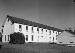 | Fort Totten | building | 1971 | 71000629 |
| Grace Episcopal Church | building | 1994 | 94001072 | |
| Pierson Farm | building | 1985 | 85001939 | |
 | Viking Lutheran Church | building | 1979 | 79001768 |
| West Antelope Bridge | structure | 1997 | 97000171 |
Every wildfire the federal occurrence database records inside this county: 6,861 of them, burning about 36,169 acres. 9 started naturally and 6,379 were recorded as arson. Each settlement page carries the fires within five miles of it.
| Reported cause | Fires |
|---|---|
| Arson/incendiarism | 6379 |
| Debris and open burning | 313 |
| Fireworks | 62 |
| Missing data/not specified/undetermined | 51 |
| Equipment and vehicle use | 18 |
| Misuse of fire by a minor | 14 |
| Natural | 9 |
| Other causes | 7 |
| Smoking | 4 |
| Power generation/transmission/distribution | 2 |
| Recreation and ceremony | 2 |
The five largest, by the area the report gives. Every one of them was set deliberately.
| Date | Cause | Size | Reported by | Name on the report |
|---|---|---|---|---|
| 14 April 2008 | Arson/incendiarism | 1,900 acres | Fort Totten Agency | 104 |
| 16 April 2006 | Arson/incendiarism | 1,303 acres | Devil's Lake Wetland Management District | BROWN WF |
| 1 November 1999 | Arson/incendiarism | 1,190 acres | Fort Totten Agency | LD2305 |
| 15 May 2014 | Arson/incendiarism | 640 acres | Fort Totten Agency | OBERON |
| 13 May 1996 | Arson/incendiarism | 630 acres | Devil's Lake Wetland Management District | WARWICK |
| 18 April 2007 | Arson/incendiarism | 489 acres | Fort Totten Agency | 181 |
| 14 April 2006 | Arson/incendiarism | 480 acres | Devil's Lake Wetland Management District | HAY PRAIRIE |
| 12 April 2003 | Arson/incendiarism | 475 acres | Fort Totten Agency | LD2706 |
Every settlement page carries the fires within five miles of it - see the settlement index below.
The NOAA Storm Events Database holds 551 reports for this county, causing no deaths, no injuries and about $14,873,250 in recorded property damage. Each settlement page carries the reports that name it.
| Kind of event | Reports |
|---|---|
| Hail | 297 |
| Thunderstorm Wind | 152 |
| Tornado | 49 |
| Flood | 25 |
| Flash Flood | 21 |
| Funnel Cloud | 6 |
| Heavy Rain | 1 |
The most serious of them, by death, then injury, then recorded damage. The accounts are quoted exactly as the forecast office filed them.
| When | Event | Place named | Harm | What the report says |
|---|---|---|---|---|
| June 2005 | Thunderstorm Wind | Esmond | $6,450,000 | Downburst winds and tornadoes tore down 31 miles of 230 kV power transmission lines crossing far eastern Pierce and western Benson counties. The 25 mile section from the Pierce county line to 2 miles northwest of Minnewaukan was blown down between 5:00 am to 5:20 am CDT by winds of 90 to 110 mph. The Great River Power Company estimated property loss in Benson county at $6.45 million. |
| June 2009 | Flood | Leeds | $2,000,000 | no account filed |
| July 2009 | Flood | Leeds | $2,000,000 | no account filed |
| August 2000 | Thunderstorm Wind | Ft Totten | $1,000,000 | Wind damage also occurred around the Fort Totten area. Several planned housing developments under construction sustained heavy damage. The Spirit Lake Casino also reported some damage. |
| June 2005 | Thunderstorm Wind | Leeds | $600,000 | A large 80,000 bushel grain bin was blown down at the BTR elevator complex near the Niles railroad spur. A grain dryer and several smaller hopper bottom bins were also blown over. |
| August 2001 | Tornado (F2) | Maddock | $300,000 | A grain elevator was heavily damaged and will likely be shut down for the rest of the year. Many trees were uprooted and a camper was overturned. 1.5 miles of powerline was blown down with 24 poles snapped. |
| September 2019 | Flash Flood | Maddock | $250,000 | Over 2 inches of rain fell in less than an hour, flooding streets and intersections. |
| July 2011 | Flood | Leeds | $250,000 | no account filed |
| August 2011 | Flood | Leeds | $250,000 | no account filed |
| July 1984 | Tornado (F1) | not stated | $250,000 | no account filed |
| May 1974 | Tornado (F2) | not stated | $250,000 | no account filed |
| June 2017 | Thunderstorm Wind | Minnewaukan | $240,000 | A deputy reported 18 to 20 power poles snapped along the highway west of Minnewauken. An accompanying photo showed a damage pattern associated with an apparent microburst with very strong outflow. Peak winds were estimated at 110 mph. |
| June 2017 | Tornado (EF2) | Knox | $200,000 | This tornado and corresponding rear flank downdraft wind produced widespread dust, which greatly reduced the visibility. Numerous ash, poplar, cottonwood, and evergreen trees were snapped or uprooted in shelterbelts and groves along its path. Peak winds of 119 mph were measured by a mobile system. |
| June 2011 | Flood | Leeds | $200,000 | no account filed |
| July 2020 | Flood | Minnewaukan | $100,000 | Portions of highway 281 and highway 2 were flooded, along with local county and township roads. Basement flooding was reported in Leeds, Minnewaukan, and Maddock. |
| July 2008 | Thunderstorm Wind | Tokio | $100,000 | Several large twelve to fourteen inch diameter trees were blown down or uprooted along Black Tiger Bay. Some trees fell on vehicles and campers in the area. |
| July 2018 | Tornado (EF2) | Warwick | $50,000 | This tornado began in Eddy County at 0129 am CST, with about half its total path length occurring in Eddy County. The total path length was about three miles. The tornado likely initiated in a bowing section of a squall line and passed just east of Warwick. Multiple power poles were snapped on both north and south sides of highway 20. Large trees were snapped in and around Warwick. Metal sheathing was torn off a grain cleaning structure. Peak winds were estimated at 115 mph. |
| June 2008 | Thunderstorm Wind | Maddock | $50,000 | The trained spotter reported a lot of dust on the leading edge of the storm and a prominent shelf cloud. |
| June 2008 | Thunderstorm Wind | Oberon | $50,000 | A rolling dust storm preceded the wind. |
| June 2008 | Hail | Maddock | $50,000 | The hail was reported by a North Dakota ARB observer. Several sections of cropland received damage across Hesper and North Viking townships. |
| August 2001 | Tornado (F2) | Maddock | $50,000 | The tornado began northwest of Maddock and travelled along a path intermittently to near Flora and near Oberon. A 40x60 foot metal shed was demolished. About 2 miles northeast of Maddock, a grain bin was pulled from its foundation and thrown about 500 yards. A hopper bin and concrete pad were also turned on end at this location. Many large trees were flattened all along the path until the tornado weakened from Flora to near Oberon. |
| July 1987 | Tornado (F1) | not stated | $25,000 | no account filed |
| May 1958 | Tornado (F3) | not stated | $25,000 | no account filed |
| July 2020 | Tornado (EF1) | Niles | $20,000 | A tornado briefly touched down near highway 2, snapping trees in a shelterbelt. A nearby RWIS mesonet sensor reported a wind gust to 101 mph. The tornado was likely wrapped in heavy rain and downburst winds. Peak winds were estimated at 105 mph. |
| June 2008 | Hail | Fillmore | $20,000 | Hail fell for twenty minutes, resulting in several sections of damaged crop land in Impark Township. |
| June 2008 | Hail | Esmond | $20,000 | Several large sections of cropland received damage in Esmond and Rich Valley Townships. |
| August 2008 | Hail | Tokio | $15,000 | no account filed |
| August 2000 | Thunderstorm Wind | Ft Totten | $10,000 | The wind blew down large tree branches, damaged a barn roof, and moved an empty grain bin several feet. |
| May 2009 | Flood | Leeds | $10,000 | no account filed |
| August 1994 | Hail | Minnewaukan | $10,000 | no account filed |
| August 2000 | Thunderstorm Wind | Minnewaukan | $5,000 | Numerous trees were uprooted in Minnewaukan. One tree fell on a porch roof. Power was out for 5 hours. |
| March 2009 | Flood | Pleasant Lake | $5,000 | no account filed |
| April 2009 | Flood | Pleasant Lake | $5,000 | no account filed |
| July 2011 | Thunderstorm Wind | Leeds | $2,000 | A NOAA wind profiler at Leeds measured the 2 minute average sustained wind speed. |
| August 2016 | Flash Flood | Oberon | $1,000 | Fields and farm access roads were flooded across southern Rock Township. |
| July 2011 | Flash Flood | Tokio | $1,000 | Several sections of roadway and farm access roads were made impassable by water flowing across. |
| June 2010 | Flash Flood | Brinsmade | $1,000 | Areas of 4 to 5 inches of rainfall produced flash flooding in fields and farm access roads in southern Normania Township. |
| August 2002 | Thunderstorm Wind | Maddock | $1,000 | Trees were blown down. |
| July 2001 | Thunderstorm Wind | Warwick | $1,000 | A tree was blown down. |
| July 2000 | Thunderstorm Wind | Oberon | $1,000 | Several antennas and trees were blown down north of Oberon. |
| August 2002 | Thunderstorm Wind | Minnewaukan | $500 | Trees and power lines were blown down. Some customers lost power for 10 hours. |
| June 2001 | Thunderstorm Wind | Leeds | $500 | Tree branches were blown down. |
| August 2001 | Thunderstorm Wind | Maddock | $500 | Branches were blown down. |
| August 2001 | Thunderstorm Wind | Maddock | $500 | Branches were blown down. |
| August 2001 | Thunderstorm Wind | Oberon | $500 | Several trees were blown over. |
| July 2001 | Thunderstorm Wind | Esmond | $500 | Tree branches were blown down. |
| July 2001 | Thunderstorm Wind | Oberon | $500 | A large tree was blown down. |
| August 2000 | Thunderstorm Wind | Warwick | $500 | Tree branches were blown down. |
| August 2000 | Thunderstorm Wind | Maddock | $500 | Tree branches were blown off in the Maddock area. |
| August 2000 | Thunderstorm Wind | Maddock | $500 | Tree branches were blown down. |
| June 1966 | Tornado (F1) | not stated | $250 | no account filed |
| April 2026 | Thunderstorm Wind | Maddock Muni Arpt | - | Measured wind gust of 58 mph on 10m sensor at NDAWN station located near Maddock, ND. |
| July 2025 | Hail | Oberon | - | Report relayed through social media. Time estimated by radar. |
| September 2025 | Hail | Leeds | - | Social media report - Time estimated via radar. Handful of nickel to quarter sized hail with one larger stone of at least half dollar size. |
| September 2025 | Hail | Leeds | - | Social media report of hail up 1.25 inches. |
| July 2024 | Thunderstorm Wind | Esmond | - | Nearby personal weather station measured maximum sustained winds of 53 MPH, with gusts to 72 MPH. |
| July 2024 | Hail | Niles | - | Public reports 1.25 inch hail. Time estimated from caller and radar. |
| July 2024 | Hail | Tokio | - | Public reports quarter sized hail. Time estimated from radar. |
| July 2024 | Hail | Niles | - | Emergency Manager reports 1 inch hail. Time estimated from radar. |
| July 2024 | Hail | York | - | Half dollar to ping pong ball sized hail. Covered 15 to 20% of the ground. |
The Survey's mineral resources record lists 4 workings inside this county. 3 still produce and 1 is closed or unrecorded. Each settlement page carries the workings within five miles of it.
| Commodity | Workings |
|---|---|
| Sand and Gravel, Construction | 4 |
The least common of them first, because a county's hundredth gravel pit says nothing its first ten did not.
| Where | Site | Commodity | Status | Recorded |
|---|---|---|---|---|
| Benson County Pit | Sand and Gravel, Construction | Producer | ||
| Cavanaugh Pit | Sand and Gravel, Construction | Producer | ||
| Clairmont Const Pit | Sand and Gravel, Construction | Producer | ||
| Siou Sand & Gravel Pit | Sand and Gravel, Construction | Past Producer |
Named settlements recorded in the Geographic Names Information System, each with the topographic sheets covering it. Villages, hamlets and abandoned places alike. Each is shown with the nearest named watercourse or landform and the survey quadrangle it falls on.
Fort Totten unorganized territory · 58370 · Fort Totten quadrangle
14 sheets, 1928 to 1994