 Block
From the record
8 National Register listings published here.
Sources: the National Register database, National Park Service
29 topographic sheets cover 7 settlements here, and 8 properties are on the National Register of Historic Places.
8 National Register listings published here.
Sources: the National Register database, National Park Service
Every property in this county listed on the National Register of Historic Places, with the year it was listed and the federal nomination document.
| Photograph | Property | Type | Listed | Reference |
|---|---|---|---|---|
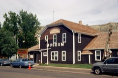 | Billings County Courthouse | building | 1977 | 77001016 |
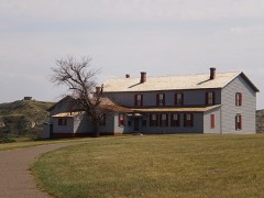 | Chateau de Mores | building | 1975 | 75001299 |
| De Mores Memorial Park | site | 2019 | 100003204 | |
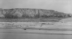 | De Mores Packing Plant Ruins | site | 1975 | 75001300 |
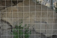 | Initial Rock | site | 1976 | 76002271 |
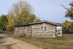 | Peaceful Valley Ranch | building | 1994 | 94000731 |
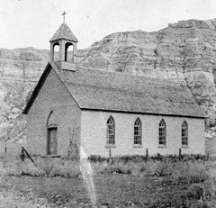 | St. Mary's Catholic Church | building | 1977 | 77001017 |
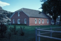 | Von Hoffman House | building | 1977 | 77001018 |
Every wildfire the federal occurrence database records inside this county: 270 of them, burning about 13,708 acres. 101 started naturally and 4 were recorded as arson. Each settlement page carries the fires within five miles of it.
| Reported cause | Fires |
|---|---|
| Natural | 101 |
| Equipment and vehicle use | 60 |
| Missing data/not specified/undetermined | 32 |
| Power generation/transmission/distribution | 24 |
| Debris and open burning | 23 |
| Recreation and ceremony | 16 |
| Railroad operations and maintenance | 7 |
| Arson/incendiarism | 4 |
| Smoking | 3 |
The five largest, by the area the report gives. None of them was recorded as arson.
| Date | Cause | Size | Reported by | Name on the report |
|---|---|---|---|---|
| 8 July 2017 | Missing data/not specified/undetermined | 4,907 acres | Dakota Prairie National Grasslands | MAGPIE |
| 15 August 2004 | Recreation and ceremony | 1,883 acres | Dakota Prairie National Grasslands | MAGPIE CAMP |
| 26 August 2000 | Natural | 1,866 acres | Dakota Prairie National Grasslands | TALKINGTON 1 |
| 12 April 2002 | Missing data/not specified/undetermined | 645 acres | Dakota Prairie National Grasslands | GORHAM |
| 19 August 2004 | Power generation/transmission/distribution | 493 acres | Dakota Prairie National Grasslands | WHITETAIL |
| 26 August 2000 | Natural | 345 acres | Dakota Prairie National Grasslands | BLACKTAIL 1 |
| 8 April 2012 | Missing data/not specified/undetermined | 326 acres | Dakota Prairie National Grasslands | EASTER FIRE |
| 27 July 2004 | Natural | 280 acres | Dakota Prairie National Grasslands | MIKES CREEK |
Every settlement page carries the fires within five miles of it - see the settlement index below.
The NOAA Storm Events Database holds 171 reports for this county, causing no deaths, 3 injuries and about $1,919,000 in recorded property damage. Each settlement page carries the reports that name it.
| Kind of event | Reports |
|---|---|
| Hail | 113 |
| Thunderstorm Wind | 39 |
| Tornado | 7 |
| Lightning | 4 |
| Flash Flood | 3 |
| Flood | 2 |
| Funnel Cloud | 2 |
| Heavy Rain | 1 |
The most serious of them, by death, then injury, then recorded damage. The accounts are quoted exactly as the forecast office filed them.
| When | Event | Place named | Harm | What the report says |
|---|---|---|---|---|
| June 1996 | Hail | Medora | 3 hurt, $25,000 | no account filed |
| July 2022 | Thunderstorm Wind | Fairfield | $1,000,000 | Extensive damage was reported throughout the community of Fairfield and surrounding areas, especially to the west. Approximately 100 power poles were snapped throughout the area. A pad mounted electrical transformer weighing approximately two tons was blown over about eight miles west of Fairfield. Six miles west of Fairfield, a 120 foot communications tower blew over, and an adjacent small building was demolished. Closer to and in the community of Fairfield, a Quonset hut was blown approximately 150 yards, and a roof on a home was severely damaged. Multiple trees in the area were uprooted and snapped, and multiple stock trailers were flipped over. |
| September 2015 | Thunderstorm Wind | Fryburg | $175,000 | Significant and severe damage was done from extreme winds on the leading edge of the line of thunderstorms. Outbuildings and vehicles badly damaged, some destroyed. |
| July 2016 | Hail | Fairfield | $150,000 | Golf ball sized hail combined with wind gusts of 70 mph to break windows and cause significant damage to siding and roofs, and vehicles. Crop damage was high. |
| July 2010 | Thunderstorm Wind | Fryburg | $95,000 | Intense thunderstorm winds resulted in damage to outbuildings on a farm. Specifically, one pole barn was destroyed, with the debris from the pole barn damaging two grain bins, a small garage, and vehicles on the farm. Based on reports from local officials and photographs of the damage, it was determined a microburst occurred. |
| July 2013 | Thunderstorm Wind | Fairfield | $75,000 | Severe thunderstorm winds flipped over a calf shelter, blew down several power poles, and rolled hay bales through fencing. |
| June 2006 | Hail | Fryburg | $75,000 | Storm accompanied by estimated 60 mph wind gusts. Damage to roofs and windows. |
| June 2021 | Thunderstorm Wind | Fairfield | $50,000 | Trees were knocked down at the residence. A neighbor nearby had a machine shed destroyed. In addition some power poles were snapped nearby. |
| May 2011 | Flood | Medora | $50,000 | See the event episode narrative for details. |
| March 2009 | Flood | Fairfield | $50,000 | Ice jams on the Little Missouri River led to flooding near Medora which inundated two homes. |
| July 2011 | Flash Flood | Medora | $25,000 | Up to four inches of very heavy rainfall resulted in the camp grounds at Medora being flash flooded. |
| August 1983 | Tornado (F1) | not stated | $25,000 | no account filed |
| July 2025 | Thunderstorm Wind | Fairfield | $20,000 | Power lines were down. |
| July 2010 | Hail | Fryburg | $20,000 | The large hail was accompanied by severe thunderstorm winds. This combination resulted in damage to windows and siding on the west side of a home. |
| June 2019 | Hail | Medora | $15,000 | A roof was damaged on a home. |
| August 2016 | Flash Flood | Fairfield | $15,000 | Heavy rain over the area resulted in water covering Highway 85 in the vicinity of the North Unit of Theodore Roosevelt National Park. Repairs were needed to the roads shoulders. |
| July 1997 | Thunderstorm Wind | Fairfield | $15,000 | Strong winds tore the roof off of a cattle barn. Damage amounts estimated. |
| August 2016 | Hail | Fairfield | $15,000 | no account filed |
| June 2006 | Hail | Medora | $10,000 | Hail accompanied by measured 68 mph wind gust on a hand held anemometer. Damage to a ranch 4 miles south of Medora included the roof and windows and tree limbs down in the farm yard. |
| August 1996 | Lightning | 4 Se Fryburg | $8,000 | no account filed |
| June 1984 | Tornado (F1) | not stated | $2,500 | no account filed |
| August 1996 | Lightning | 2 Sw Fryburg | $2,000 | no account filed |
| July 2007 | Thunderstorm Wind | Medora | $1,500 | Multiple tree limbs down. |
| July 2025 | Thunderstorm Wind | Fairfield | - | Thunderstorm wind gusts were estimated by a trained spotter. |
| July 2025 | Thunderstorm Wind | Fryburg | - | Thunderstorm wind gusts were estimated by the public. |
| July 2022 | Thunderstorm Wind | Medora | - | Thunderstorm wind gusts were estimated by the public. |
| March 2015 | Thunderstorm Wind | Fryburg | - | The National Weather Service received no reports of damage. |
| September 2014 | Hail | Fairfield | - | There were no reports of damage. |
| September 2014 | Hail | Fairfield | - | There were no reports of damage. |
| September 2014 | Hail | Fairfield | - | There were no reports of damage. |
| August 2013 | Hail | Fairfield | - | Winds up to 45 miles per hour were also reported. |
| July 2013 | Funnel Cloud | Fairfield | - | A brief funnel cloud was reported. |
| September 2010 | Funnel Cloud | Fryburg | - | A brief funnel cloud appeared. |
| September 2010 | Hail | Fryburg | - | Strong thunderstorm winds accompanied the large hail. |
| September 2010 | Thunderstorm Wind | Fryburg | - | Large hail accompanied the strong thunderstorm winds. |
| July 2009 | Tornado (EF0) | Medora | - | A brief tornado touchdown was reported. No reports of damage or injuries were received. |
| August 2008 | Hail | Gorham | - | Hail was accompanied by estimated 60 mph winds. |
| May 2007 | Thunderstorm Wind | Medora | - | RAWS site near Painted Canyon visitor center. |
| July 2005 | Hail | Fairfield | - | Reported on Highway 85. |
| July 2005 | Hail | Fairfield | - | Reported by a cooperative observer. Also had 0.80 inches of rain. |
| June 2003 | Hail | Fryburg | - | Mainly pea size hail along with very heavy rain. |
| July 2003 | Hail | Fairfield | - | Mostly pea size hail with this storm. |
| July 2003 | Hail | Medora | - | Heavy rain reported with the storm. |
| July 2003 | Hail | Medora | - | Hail damaged numerous vehicles in and around the Medora area. |
| July 2002 | Thunderstorm Wind | Fairfield | - | Rainfall amounts from storm measured at 2.50 inches. |
| June 2002 | Hail | Fairfield | - | Hail drifted two (2) feet in depth. |
| June 2002 | Flash Flood | Fairfield | - | Public reported four (4) feet of water over the road. |
| July 2001 | Thunderstorm Wind | Fairfield | - | Report of crops destroyed. |
| July 2001 | Thunderstorm Wind | Medora | - | Several tree's uprooted. |
| July 2001 | Thunderstorm Wind | Fairfield | - | Reports of tree's down and damage to farm buildings. |
| July 2001 | Heavy Rain | Fairfield | - | Emergency management reported 2 inches of rain within a 15 minute period causing road flooding. |
| July 2001 | Thunderstorm Wind | Fairfield | - | Crops destroyed. |
| June 2000 | Tornado (F0) | Fairfield | - | Tornado traveled in open country. |
| August 2000 | Lightning | Fairfield | - | Lightning started a praire fire. |
| June 1998 | Hail | Medora | - | Deputy reported ground was white with hail. |
| August 1998 | Lightning | Medora | - | 53 acres theodore roosevelt nat'l park by fire caused by lightning |
| July 1997 | Thunderstorm Wind | Medora | - | winds occurred 3 E Medora |
| June 2025 | Hail | Fairfield | - | no account filed |
| June 2025 | Hail | Fairfield | - | no account filed |
| July 2025 | Thunderstorm Wind | Fairfield | - | no account filed |
The Survey's mineral resources record lists 55 workings inside this county. 6 still produce and 49 are closed or unrecorded. Each settlement page carries the workings within five miles of it.
| Commodity | Workings |
|---|---|
| Stone, Crushed/Broken | 19 |
| Sand and Gravel, Construction | 19 |
| Uranium | 17 |
| Lignite | 1 |
The least common of them first, because a county's hundredth gravel pit says nothing its first ten did not.
| Where | Site | Commodity | Status | Recorded |
|---|---|---|---|---|
| Smith #3 Mine | Uranium, Lignite | Past Producer | ||
| American Lutheran Church Property | Uranium | Prospect | ||
| Baranko | Uranium | Past Producer | ||
| Church No 1 | Uranium | Past Producer | ||
| Dakota Oil Enterprises Occurrence | Uranium | Occurrence | ||
| Geary #1 Prospect | Uranium | Occurrence | ||
| Geary Lease | Uranium | Past Producer | ||
| Hecker No 1 | Uranium | Past Producer | ||
| Johnson | Uranium | Past Producer | ||
| Kiyote Claims Uranium Occurrence | Uranium | Occurrence | ||
| Klym | Uranium | Past Producer | ||
| Northern Pacific No 1 | Uranium | Past Producer | ||
| Sec. 2-137n-100w Unknown | Uranium | Past Producer | ||
| Smith #1 Mine | Uranium | Prospect | ||
| Talkington | Uranium | Past Producer | ||
| Unnamed | Uranium | Past Producer | ||
| Unnamed Prospect | Uranium | Prospect | ||
| Dorval Gravel Pit | Sand and Gravel, Construction | Producer | ||
| Evoniuk Gravel Pit | Sand and Gravel, Construction | Producer | ||
| Gravel Pit | Stone, Crushed/Broken | Past Producer | ||
| Gravel Pit | Sand and Gravel, Construction | Past Producer | ||
| Gravel Pit | Sand and Gravel, Construction | Past Producer | ||
| Gravel Pit | Sand and Gravel, Construction | Past Producer | ||
| Gravel Pit | Sand and Gravel, Construction | Past Producer | ||
| Gravel Pit | Sand and Gravel, Construction | Past Producer | ||
| Gravel Pit | Sand and Gravel, Construction | Past Producer | ||
| Gravel Pit | Sand and Gravel, Construction | Past Producer | ||
| Gravel Pit | Sand and Gravel, Construction | Past Producer | ||
| Gravel Pit | Sand and Gravel, Construction | Past Producer | ||
| Gravel Pit | Sand and Gravel, Construction | Past Producer | ||
| Gravel Pit | Sand and Gravel, Construction | Past Producer | ||
| Gravel Pit | Sand and Gravel, Construction | Past Producer | ||
| Lignite Mine | Stone, Crushed/Broken | Past Producer | ||
| Meyer Gravel Pit | Sand and Gravel, Construction | Producer | ||
| Sand Pit | Sand and Gravel, Construction | Producer | ||
| Scoria | Stone, Crushed/Broken | Past Producer | ||
| Scoria Pit | Stone, Crushed/Broken | Past Producer | ||
| Scoria Pit | Stone, Crushed/Broken | Past Producer | ||
| Scoria Pit | Sand and Gravel, Construction | Past Producer | ||
| Scoria Pit | Stone, Crushed/Broken | Past Producer | ||
| Scoria Pit | Stone, Crushed/Broken | Past Producer | ||
| Scoria Pit | Stone, Crushed/Broken | Past Producer | ||
| Scoria Pit | Stone, Crushed/Broken | Past Producer | ||
| Scoria Pit | Stone, Crushed/Broken | Past Producer | ||
| Scoria Pit | Stone, Crushed/Broken | Past Producer | ||
| Scoria Pit | Stone, Crushed/Broken | Past Producer | ||
| Scoria Pit | Stone, Crushed/Broken | Past Producer | ||
| Scoria Pit | Stone, Crushed/Broken | Past Producer | ||
| Scoria Pit | Stone, Crushed/Broken | Past Producer | ||
| Scoria Pit | Stone, Crushed/Broken | Producer | ||
| Scoria Pit | Stone, Crushed/Broken | Past Producer | ||
| Scoria Pit | Stone, Crushed/Broken | Past Producer | ||
| Scorpia Pit | Stone, Crushed/Broken | Past Producer | ||
| Stigen Gravel Pit | Sand and Gravel, Construction | Producer | ||
| Whitetail Gravel Pit | Sand and Gravel, Construction | Past Producer |
Named settlements recorded in the Geographic Names Information System, each with the topographic sheets covering it. Villages, hamlets and abandoned places alike. Each is shown with the nearest named watercourse or landform and the survey quadrangle it falls on.
North Billings unorganized territory · 58627 · Fairfield quadrangle
9 sheets, 1953 to 1997
South Billings unorganized territory · 58645 · On Railroad Creek · Medora quadrangle
6 sheets, 1953 to 1997
North Billings unorganized territory · 58645 · Fryburg NW quadrangle
7 sheets, 1953 to 1997
North Billings unorganized territory · 58622 · Belfield quadrangle
7 sheets, 1953 to 1997
South Billings unorganized territory · 58645 · Tracy Mountain quadrangle
7 sheets, 1953 to 1997