 Block
From the record
5 National Register listings published here.
Sources: the National Register database, National Park Service
37 topographic sheets cover 26 settlements here, and 5 properties are on the National Register of Historic Places.
5 National Register listings published here.
Sources: the National Register database, National Park Service
Every property in this county listed on the National Register of Historic Places, with the year it was listed and the federal nomination document.
| Photograph | Property | Type | Listed | Reference |
|---|---|---|---|---|
| Ole Crogen Farm District | district | 1987 | 87001779 | |
 | Main, North Dakota School of Forestry, Old | building | 2006 | 06000532 |
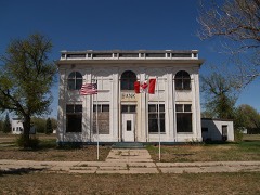 | State Bank of Antler | building | 88000986 | |
| State Bank of Antler | building | 2019 | 100003620 | |
| Swedish Zion Lutheran Church | building | 2013 | 13000138 |
Every wildfire the federal occurrence database records inside this county: 124 of them, burning about 3,974 acres. 5 started naturally and 6 were recorded as arson. Each settlement page carries the fires within five miles of it.
| Reported cause | Fires |
|---|---|
| Debris and open burning | 47 |
| Missing data/not specified/undetermined | 37 |
| Equipment and vehicle use | 19 |
| Arson/incendiarism | 6 |
| Natural | 5 |
| Smoking | 4 |
| Fireworks | 3 |
| Power generation/transmission/distribution | 2 |
| Recreation and ceremony | 1 |
The five largest, by the area the report gives. None of them was recorded as arson.
| Date | Cause | Size | Reported by | Name on the report |
|---|---|---|---|---|
| 21 April 2010 | Missing data/not specified/undetermined | 1,011 acres | J. Clark Salyer National Wildlife Refuge | SHEFLO WF |
| 27 October 1997 | Debris and open burning | 740 acres | J. Clark Salyer National Wildlife Refuge | DEERING #1 |
| 24 March 2008 | Missing data/not specified/undetermined | 500 acres | North Dakota State Forest Service | GREEK |
| 25 October 2016 | Equipment and vehicle use | 200 acres | North Dakota State Forest Service | DUSTY KUHNS/KROKI |
| 28 April 2016 | Debris and open burning | 180 acres | North Dakota State Forest Service | BALLENTYNE |
| 15 October 2007 | Debris and open burning | 160 acres | North Dakota State Fire Marshal's Office | not named |
| 24 October 2018 | Missing data/not specified/undetermined | 160 acres | North Dakota State Forest Service | KIHLE CONTROLLED BURN |
| 13 May 2013 | Missing data/not specified/undetermined | 158 acres | J. Clark Salyer National Wildlife Refuge | SIVERTSON |
Every settlement page carries the fires within five miles of it - see the settlement index below.
The NOAA Storm Events Database holds 314 reports for this county, causing no deaths, 10 injuries and about $13,049,030 in recorded property damage. Each settlement page carries the reports that name it.
| Kind of event | Reports |
|---|---|
| Hail | 182 |
| Thunderstorm Wind | 73 |
| Tornado | 34 |
| Flood | 8 |
| Flash Flood | 7 |
| Funnel Cloud | 5 |
| Heavy Rain | 4 |
| Lightning | 1 |
The most serious of them, by death, then injury, then recorded damage. The accounts are quoted exactly as the forecast office filed them.
| When | Event | Place named | Harm | What the report says |
|---|---|---|---|---|
| June 1974 | Tornado (F2) | not stated | 6 hurt, $250,000 | no account filed |
| June 2002 | Thunderstorm Wind | Bottineau | 2 hurt | Two people were injured by flying debris at a campground. |
| June 1986 | Tornado (F3) | not stated | 1 hurt, $2,500,000 | no account filed |
| June 1972 | Tornado (F2) | not stated | 1 hurt, $250,000 | no account filed |
| June 2016 | Thunderstorm Wind | Lansford | $5,000,000 | Widespread damage occurred in the city of Lansford. A mobile home sustained substantial damage as the roof and part of the wall structure were removed. Permanent homes had roof damage and broken windows. The grain elevator sustained an estimated three to four million dollars in damages as the primary structure along with multiple grain bins, some containing grain, were damaged or destroyed. Tree damage was widespread and extensive, as many very large trees were uprooted or snapped. Winds throughout northwest into north central North Dakota were as high as 70 mph, with winds estimated as high as 100 mph around Lansford. The event at Lansford may have been a microburst, leading to the higher winds and more extensive damage. No injuries or deaths were reported. |
| June 2005 | Flash Flood | Souris | $625,000 | no account filed |
| June 2013 | Flood | Westhope | $525,000 | This flooding, along the Souris (Mouse) River, was in part due to earlier snow melt runoff and releases from upstream dams reaching this part of Bottineau County. Heavy rains in June added to the high water. Damage was reported to roads and bridges. |
| July 2004 | Thunderstorm Wind | Lansford | $500,000 | no account filed |
| July 2025 | Hail | Newburg | $400,000 | Extensive hail damage throughout the community of Newberg including damaged roofs and vehicles. |
| July 2024 | Hail | Westhope | $400,000 | Hail damaged roofs, siding, and windows on houses along with car windshields in the community of Westhope. |
| July 2023 | Thunderstorm Wind | Landa | $350,000 | Seven empty hopper style grain bins were blown over, and one empty standard style grain bin was also destroyed. Various trees were damaged, with some smaller trees broken off. The wind was also accompanied by up to one-inch diameter hail and caused extensive crop damage in the area. |
| June 2014 | Flood | Lansford | $296,000 | Flooding occurred over western Bottineau County. Damage occurred to roads and culverts with many wash outs along township roads. There was crop damage as well. Rain amounts ranged from 2.50 inches in Bottineau County to as much as 7.00 inches in Renville County. |
| May 2011 | Flood | Antler | $250,000 | See the event episode narrative for details. |
| July 1977 | Tornado | not stated | $250,000 | no account filed |
| April 2009 | Flood | Antler | $191,000 | Rapid snowmelt caused the Souris River and overland areas to flood, washing out county and township roads. |
| June 2024 | Thunderstorm Wind | Bottineau Arpt | $150,000 | The Metigoshe Drive In building was severely damaged by thunderstorm wind gusts with the front awning and much of the roof completely torn off. |
| June 2020 | Tornado (EF1) | Bottineau | $150,000 | The tornado touched down east-northeast of Carbury, and based on the damage that occurred was rated EF-1. This was the second of two tornadoes near this location within minutes of each other. Two properties were damaged by this second tornado. Damaged was a barn door blown off and the roof torn off, a machine shed damaged, a swing set blown away and large trees snapped and uprooted. A car port was also damaged. Tornado winds were estimated, based on the damage done, at around 95 mph. |
| June 2005 | Flash Flood | Newburg | $104,000 | 8 inches of water over county roads following 2.6 inches of rain. |
| July 2007 | Thunderstorm Wind | Lansford | $80,000 | One quonset was torn from its foundation and thrown into a second quonset. Tree branches were broken and some trees uprooted. A grain bin was blown into a diesel fuel storage tank, breaking the valve and resulting in 2000 gallons of spilled fuel. Emergency Manager indicated that the damage was consistent with high wind and not a tornado. |
| June 2011 | Thunderstorm Wind | Willow City | $75,000 | Thunderstorm wind damage was sustained to trees and a large barn was blown down. |
| May 2010 | Thunderstorm Wind | Bottineau | $75,000 | Strong thunderstorm winds resulted in damage on the west side of Bottineau. Several grain bins were knocked over, one transmission tower was knocked down, and several trees sustained damage. |
| July 2025 | Hail | Maxbass | $50,000 | Damage to home, vehicles, and buildings. |
| September 2019 | Hail | Westhope | $50,000 | Windshields were broken on cars. Homes and mailboxes were damaged. |
| June 2018 | Hail | Gardena | $50,000 | Farm damage occurred to buildings and crops. |
| June 2011 | Thunderstorm Wind | Willow City | $50,000 | Strong thunderstorm winds uprooted numerous trees and blew down utility poles in the Willow City area. |
| July 2007 | Thunderstorm Wind | Newburg | $40,000 | One foot diameter trees were down. The high wind also knocked over and damaged a grain bin and auger. |
| June 2020 | Thunderstorm Wind | Bottineau Arpt | $35,000 | Power lines blew down and a large tree blew down onto a road. |
| March 2009 | Flood | Antler | $35,000 | Overland flooding damaged county and township roads. No homes were flooded. Flooding continued into April. |
| September 2019 | Hail | Maxbass | $30,000 | A window was broken on the home, and holes were punched in the siding. |
| July 1997 | Thunderstorm Wind | Lansford | $30,000 | thunderstorm winds tore roof off of dairy barn. The winds also moved a trailer house 3 feet off of its foundation. |
| August 2016 | Hail | Bottineau Arpt | $25,000 | no account filed |
| June 1984 | Tornado (F1) | not stated | $25,000 | no account filed |
| August 1978 | Tornado (F1) | not stated | $25,000 | no account filed |
| July 1968 | Tornado (F1) | not stated | $25,000 | no account filed |
| September 1956 | Tornado | not stated | $25,000 | no account filed |
| August 2025 | Thunderstorm Wind | Bottineau | $20,000 | Multiple power poles blew down. |
| June 2005 | Flash Flood | Lansford | $20,000 | Street flooding. |
| July 1997 | Lightning | Newburg | $15,000 | lightning struck an oil tank 2 E of Newburg. The tank burned to the ground |
| July 2022 | Thunderstorm Wind | Lansford | $10,000 | A quonset farm building was damaged. |
| June 2009 | Flash Flood | Bottineau Arpt | $10,000 | Rainfall amounts ranging from three to four inches in one hour resulted in flash flooding over far eastern Bottineau County. Water was reported over Highway Five west of Dunseith, and was closed for several hours. A few county roads were closed due to high water and minor repairs were needed. |
| May 2007 | Hail | Lansford | $10,000 | There was damage to siding on a few houses. |
| July 1997 | Tornado (F0) | Kramer | $10,000 | brief tornado touchdown 6 NW of Kramer. a few power poles and trees were snapped. |
| June 1997 | Tornado (F0) | Bottineau | $10,000 | Small tornado touched down briefly. While it was on the ground it tore down a few power poles and some trees. Property damage estimated. |
| June 1997 | Tornado (F0) | Westhope | $10,000 | Another weak tornado formed a few hours after the first. This tornado took out some more power lines and damaged a few small grain bins. Property damage amount estimated. |
| June 1995 | Thunderstorm Wind | Gardena | $5,000 | no account filed |
| June 2012 | Thunderstorm Wind | Bottineau Arpt | $4,000 | Estimated winds up to 65 miles per hour were reported with minor tree damage. |
| July 2020 | Thunderstorm Wind | Westhope | $3,000 | Shingles were blown off a roof. |
| June 2019 | Thunderstorm Wind | Landa | $3,000 | A crab apple tree which was one foot in diameter blew down. |
| July 2015 | Thunderstorm Wind | Bottineau Arpt | $3,000 | Small tree branches were broken off. |
| July 1982 | Tornado (F0) | not stated | $30 | no account filed |
| June 2023 | Thunderstorm Wind | Kramer | - | The public estimated wind gusts of 60 mph. |
| July 2023 | Thunderstorm Wind | Kramer | - | The strong thunderstorm winds combined with small hail to strip a nearby corn field down to its stalks. |
| May 2022 | Tornado (EFU) | Landa | - | The tornado touched down in an open field southeast of Landa. The tornado impacted no structures and so there was no damage to evaluate. By National Weather Service policy the tornado is rated EF Unknown. |
| July 2022 | Thunderstorm Wind | Lansford | - | Thunderstorm wind gusts were estimated by a trained spotter. |
| July 2022 | Thunderstorm Wind | Lansford | - | Thunderstorm wind gusts were estimated by a trained spotter. |
| June 2021 | Thunderstorm Wind | Willow City | - | A trained spotter estimated thunderstorm wind gusts of 60 mph. |
| July 2020 | Thunderstorm Wind | Lansford | - | A trained spotter estimated wind gusts to 70 mph. |
| June 2020 | Tornado (EFU) | Roth | - | The tornado touched down east-northeast of Carbury. The tornado produced no damage to evaluate and so by National Weather Service policy was rated EF Unknown. This was the first of two tornadoes near this location within minutes of each other. The second tornado impacted structures and produced damage. |
| July 2019 | Thunderstorm Wind | Bottineau | - | A trained spotter estimated thunderstorm wind gusts to 70 mph. |
| August 2016 | Funnel Cloud | Bottineau | - | An elongated funnel cloud developed north of the city of Bottineau. |
The Survey's mineral resources record lists 3 workings inside this county. 1 still produces and 2 are closed or unrecorded. Each settlement page carries the workings within five miles of it.
| Commodity | Workings |
|---|---|
| Sand and Gravel, Construction | 3 |
The least common of them first, because a county's hundredth gravel pit says nothing its first ten did not.
| Where | Site | Commodity | Status | Recorded |
|---|---|---|---|---|
| Mcgann Pit | Sand and Gravel, Construction | Unknown | ||
| Nelson Pit & Plant | Sand and Gravel, Construction | Producer | ||
| Schafer Pit | Sand and Gravel, Construction | Past Producer |
Named settlements recorded in the Geographic Names Information System, each with the topographic sheets covering it. Villages, hamlets and abandoned places alike. Each is shown with the nearest named watercourse or landform and the survey quadrangle it falls on.