 Block
From the record
2 National Register listings published here.
Sources: the National Register database, National Park Service
18 topographic sheets cover 8 settlements here, and 2 properties are on the National Register of Historic Places.
2 National Register listings published here.
Sources: the National Register database, National Park Service
Every property in this county listed on the National Register of Historic Places, with the year it was listed and the federal nomination document.
| Photograph | Property | Type | Listed | Reference |
|---|---|---|---|---|
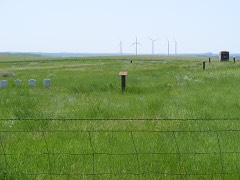 | Fort Dilts | site | 1980 | 80002907 |
| Emma Petznick and Otto Schade House | building | 2008 | 08000313 |
Every wildfire the federal occurrence database records inside this county: 64 of them, burning about 1,602 acres. 13 started naturally and none was recorded as arson. Each settlement page carries the fires within five miles of it.
| Reported cause | Fires |
|---|---|
| Equipment and vehicle use | 37 |
| Natural | 13 |
| Debris and open burning | 4 |
| Missing data/not specified/undetermined | 4 |
| Railroad operations and maintenance | 3 |
| Recreation and ceremony | 1 |
| Smoking | 1 |
| Fireworks | 1 |
The five largest, by the area the report gives. None of them was recorded as arson.
| Date | Cause | Size | Reported by | Name on the report |
|---|---|---|---|---|
| 16 August 2002 | Natural | 640 acres | Ludlow Volunteer Fire Department | HOLLECHECK |
| 21 August 2010 | Natural | 299 acres | Miles City Field Office | KID CREEK |
| 16 August 2002 | Natural | 150 acres | North Dakota Field Office | BOX ELDER |
| 15 March 2016 | Equipment and vehicle use | 73 acres | North Dakota Field Office | MILLER |
| 19 March 2005 | Debris and open burning | 60 acres | North Dakota State Forest Service | not named |
| 23 August 2005 | Natural | 45 acres | North Dakota State Forest Service | not named |
| 20 August 2005 | Equipment and vehicle use | 30 acres | North Dakota State Forest Service | not named |
| 28 July 2005 | Equipment and vehicle use | 30 acres | North Dakota State Forest Service | not named |
Every settlement page carries the fires within five miles of it - see the settlement index below.
The NOAA Storm Events Database holds 297 reports for this county, causing no deaths, 1 injury and about $3,416,280 in recorded property damage. Each settlement page carries the reports that name it.
| Kind of event | Reports |
|---|---|
| Hail | 164 |
| Thunderstorm Wind | 102 |
| Tornado | 14 |
| Funnel Cloud | 8 |
| Lightning | 4 |
| Flood | 3 |
| Flash Flood | 1 |
| Heavy Rain | 1 |
The most serious of them, by death, then injury, then recorded damage. The accounts are quoted exactly as the forecast office filed them.
| When | Event | Place named | Harm | What the report says |
|---|---|---|---|---|
| June 1977 | Tornado (F2) | not stated | 1 hurt, $250,000 | no account filed |
| September 2009 | Hail | Rhame | $600,000 | A one to two mile wide swath of large and destructive hail was reported. The largest stone was measured at three and one half inches in diameter. There was significant damage to roofs on the north and east sides of Bowman, and to structures in rural north and east Bowman County. |
| June 2020 | Thunderstorm Wind | Bowman | $400,000 | Thunderstorm winds blew part of the roof off of the West River Clinic on the southeast side of Bowman. No damage occurred to mobile homes being transported, gas station awnings, campers, or other structures in the area around the clinic. There appeared to be a significant overhang of the roof on that upwind side of the building, where the wind direction and speed caught it just in the right location, to cause the damage. All the debris from the roof blew in a north-northwest direction, with some insulation making it to the Bowman School. |
| June 2007 | Flood | Bowman | $400,000 | Total 5.6 inches of rain was reported over the duration of the rain event. Spring creek was running out of its banks. Water was running across farm roads and fields. |
| August 2007 | Thunderstorm Wind | Bowman | $300,000 | Farms damaged 9 miles south and 4 miles east of Bowman, 7 south and 3 east of Bowman, and 2 south and 3 east of Bowman. Some damage significant and to grain bins, barns, other outbuildings. and crops. |
| July 2025 | Thunderstorm Wind | Bowman | $250,000 | A large pole barn building was severely damaged, with the majority of the roofing material and rafters blown off, one wall completely destroyed, and another wall mostly destroyed. The main leg of a grain distribution system was completely blown over, along with the bin distribution pipes. Multiple large grain bins and hopper bins were dented, with one hopper bin completely blown over. |
| June 2019 | Hail | Rhame | $250,000 | Substantial damage was reported to roofs and siding in Rhame. Tree leaves were also stripped. |
| July 2017 | Thunderstorm Wind | Griffin | $250,000 | Power lines were down near Griffin. |
| June 2015 | Tornado (EF1) | Bowman Arpt | $165,000 | This tornado crossed the state line from Bowman County, North Dakota, into Harding County, South Dakota, in the National Weather Service Rapid City County Warning Area.||The total path length of the tornado was nearly four miles. In Bowman County it was on the ground for a little more than two and a half miles and in Harding County for about a mile and a quarter.||In North Dakota the tornado did damage on a farm near 45.96 north latitude and 103.41 west longitude, about one mile north of the county and state line. On that farm outbuildings and fences were damaged and trees were uprooted. The farm house had shingles torn from the roof. Also, 21 wooden power poles were damaged to varying degree. The tornado damage corresponded to higher end EF1 and from that wind speeds were estimated to be around 105 mph. In South Dakota the tornado impacted no structures and for that segment it was rated EF0, with lower wind speeds. The overall tornado is rated EF1.||See StormData entries for this tornado from Harding County. |
| July 2010 | Thunderstorm Wind | Scranton | $150,000 | Significant damage was done on a farm. Empty grain bins were torn from their foundations and rolled up fence wire was rolled through pastures. Many trees were uprooted and fence posts were broken off at ground level. Quarter size hail also fell and crops were damaged. There was concern that the damage was tornadic. However, after speaking with eye witnesses and obtaining damage descriptions and viewing photos it was determined that it was not tornado damage. |
| July 2017 | Thunderstorm Wind | Rhame | $100,000 | A barn was destroyed with the debris completely removed from the original site. |
| June 2019 | Hail | Rhame | $50,000 | Vehicles were dented by the hail. |
| June 2010 | Tornado (EF0) | Rhame | $50,000 | A metal calf shed was destroyed at a farmstead one half mile south of Rhame. The shed was blown one quarter of a mile through several fences. |
| June 2008 | Flash Flood | Bowman | $50,000 | Heavy rainfall from an isolated thunderstorm produced flash flooding within the city of Bowman. Water ran through yards and some basement flooding was reported. The rain was so heavy that visibility was reduced to two city blocks. |
| March 2009 | Flood | Rhame | $37,000 | Overland flooding damaged county and township roads. Three homes were flooded. |
| June 1984 | Tornado (F1) | not stated | $25,000 | no account filed |
| June 1966 | Tornado | not stated | $25,000 | no account filed |
| July 2009 | Hail | Bowman Arpt | $15,000 | Hail in this swath ranged from one inch diameter to 1.75 inch diameter. The largest stones fell about five miles north of Bowman and about 6.5 miles north-northwest of Buffalo Springs. There was minor crop and property damage. |
| August 2009 | Hail | Haley | $15,000 | Severe hail damaged two vehicles and one camper. |
| July 2010 | Thunderstorm Wind | Gascoyne | $10,000 | The strong thunderstorm winds resulted in damage to a grain bin and some crop damage. |
| May 2007 | Thunderstorm Wind | Bowman | $5,000 | Trees down in Bowman. |
| July 1998 | Thunderstorm Wind | Rhame | $5,000 | Two corrals were destroyed and a highline power line was down. |
| June 2010 | Thunderstorm Wind | Buffalo Spgs | $3,000 | A large mature tree was blown down by the strong thunderstorm winds. |
| June 1971 | Tornado (F1) | not stated | $2,500 | no account filed |
| June 1971 | Tornado (F1) | not stated | $2,500 | no account filed |
| August 2019 | Hail | Haley | $2,000 | A window was broken due to the wind driven hail. |
| July 2017 | Thunderstorm Wind | Rhame | $2,000 | A motorcycle was knocked over and a flag was torn up. |
| July 2010 | Hail | Rhame | $2,000 | The large hail broke out the windsheild on a truck. |
| August 1978 | Tornado (F1) | not stated | $250 | no account filed |
| August 1982 | Tornado (F0) | not stated | $30 | no account filed |
| June 2025 | Thunderstorm Wind | Rhame | - | Thunderstorm wind gusts were estimated by a trained spotter. |
| July 2025 | Thunderstorm Wind | Rhame | - | Thunderstorm wind gusts were estimated by the public. |
| July 2025 | Thunderstorm Wind | Bowman | - | Thunderstorm wind gusts were estimated by Emergency Management. |
| July 2020 | Thunderstorm Wind | Haley | - | Thunderstorm wind gusts were estimated by the public. |
| July 2020 | Thunderstorm Wind | Rhame | - | Thunderstorm wind gusts were estimated by a trained spotter. |
| July 2020 | Thunderstorm Wind | Bowman | - | Thunderstorm wind gusts were estimated by the public. |
| August 2020 | Thunderstorm Wind | Bowman | - | Thunderstorm wind gusts were estimated by the Emergency Manager. |
| August 2020 | Thunderstorm Wind | Rhame | - | Thunderstorm wind gusts were reported by Emergency Management. |
| June 2020 | Thunderstorm Wind | Rhame | - | A trained spotter estimated thunderstorm wind gusts of 60 mph. |
| June 2020 | Thunderstorm Wind | Rhame | - | A trained spotter estimated thunderstorm wind gusts of 70 mph. |
| August 2019 | Thunderstorm Wind | Scranton | - | Emergency management estimated thunderstorm wind gusts to 75 mph. |
| May 2018 | Funnel Cloud | Bowman | - | A funnel cloud developed in the vicinity of Bowman. |
| July 2018 | Thunderstorm Wind | Haley | - | Law Enforcement estimated thunderstorm wind gusts of 60 mph. |
| July 2018 | Thunderstorm Wind | Bowman | - | Emergency management estimated thunderstorm wind gusts of 60 mph. |
| August 2018 | Thunderstorm Wind | Rhame | - | A trained spotter estimated thunderstorm wind gusts of 60 mph. |
| June 2015 | Thunderstorm Wind | Rhame | - | A trained spotter west-southwest of Rhame reported strong thunderstorm wind gusts. |
| July 2015 | Thunderstorm Wind | Bowman | - | The public reported the strong thunderstorm wind gusts. |
| June 2013 | Tornado (EF0) | Bowman Arpt | - | Brief tornado touchdown near Bowman, reported by North Dakota State Water Commission. There were no reports of damage so the tornado was rated EF0. |
| August 2013 | Thunderstorm Wind | Scranton | - | A severe thunderstorm wind gust was reported. |
| May 2013 | Thunderstorm Wind | Haley | - | Pea size hail accompanied the strong winds. |
| July 2012 | Thunderstorm Wind | Rhame | - | No damage was reported with this severe wind gust. |
| May 2011 | Heavy Rain | Rhame | - | A storm total rainfall of 2.01 inches was reported. |
| May 2011 | Funnel Cloud | Rhame | - | A brief funnel cloud was observed by a trained weather spotter. This report was relayed through the Bowman County Emergency Manager. |
| July 2011 | Hail | Rhame | - | There were no damage reports received. |
| July 2011 | Thunderstorm Wind | Rhame | - | Strong thunderstorm winds occurred over southwest Bowman County. |
| August 2011 | Thunderstorm Wind | Rhame | - | Nickel size hail accompanied the strong winds. |
| August 2011 | Thunderstorm Wind | Bowman | - | A report of a severe wind gust was received. |
| June 2010 | Thunderstorm Wind | Rhame | - | No reports of damage from the strong winds was reported. |
| June 2010 | Thunderstorm Wind | Griffin | - | This report was relayed by the Bowman County Emergency Manager. |
| June 2010 | Thunderstorm Wind | Scranton | - | This report was relayed by the Bowman County Emergency Manager. |
The Survey's mineral resources record lists 9 workings inside this county. 5 still produce and 4 are closed or unrecorded. Each settlement page carries the workings within five miles of it.
| Commodity | Workings |
|---|---|
| Sand and Gravel, Construction | 9 |
The least common of them first, because a county's hundredth gravel pit says nothing its first ten did not.
| Where | Site | Commodity | Status | Recorded |
|---|---|---|---|---|
| Alvin Tollefsrud | Sand and Gravel, Construction | Producer | ||
| Fisher Sand & Gravel | Sand and Gravel, Construction | Unknown | ||
| John Bowman | Sand and Gravel, Construction | Producer | ||
| Melvin & Roseman Miller | Sand and Gravel, Construction | Past Producer | ||
| Rhame Gravel Pit | Sand and Gravel, Construction | Unknown | ||
| Rhame Pit | Sand and Gravel, Construction | Producer | ||
| Roy Kern Pit | Sand and Gravel, Construction | Past Producer | ||
| Stanley Palczewski | Sand and Gravel, Construction | Producer | ||
| Walt Boxeth | Sand and Gravel, Construction | Producer |
Named settlements recorded in the Geographic Names Information System, each with the topographic sheets covering it. Villages, hamlets and abandoned places alike. Each is shown with the nearest named watercourse or landform and the survey quadrangle it falls on.