 Block
From the record
4 National Register listings published here.
Sources: the National Register database, National Park Service
28 topographic sheets cover 18 settlements here, and 4 properties are on the National Register of Historic Places.
4 National Register listings published here.
Sources: the National Register database, National Park Service
Every property in this county listed on the National Register of Historic Places, with the year it was listed and the federal nomination document.
| Photograph | Property | Type | Listed | Reference |
|---|---|---|---|---|
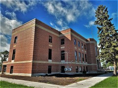 | Burke County Courthouse | building | 1985 | 85002979 |
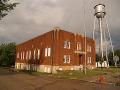 | Burke County World War Memorial Hall | building | 2018 | 100001952 |
| William E. Metzger House | building | 2007 | 07000841 | |
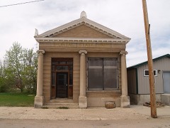 | Portal State Bank | building | 1996 | 96001067 |
Every wildfire the federal occurrence database records inside this county: 70 of them, burning about 4,490 acres. 4 started naturally and none was recorded as arson. Each settlement page carries the fires within five miles of it.
| Reported cause | Fires |
|---|---|
| Equipment and vehicle use | 22 |
| Debris and open burning | 19 |
| Missing data/not specified/undetermined | 13 |
| Power generation/transmission/distribution | 7 |
| Natural | 4 |
| Railroad operations and maintenance | 2 |
| Other causes | 2 |
| Smoking | 1 |
The five largest, by the area the report gives. None of them was recorded as arson.
| Date | Cause | Size | Reported by | Name on the report |
|---|---|---|---|---|
| 19 April 2008 | Missing data/not specified/undetermined | 1,500 acres | North Dakota State Forest Service | KLITZKE |
| 22 April 2020 | Debris and open burning | 645 acres | Lostwood Wetland Management District | ECKART |
| 29 April 1997 | Equipment and vehicle use | 460 acres | Crosby Wetland Management District | JESSON WF |
| 13 May 2013 | Power generation/transmission/distribution | 360 acres | North Dakota State Forest Service | RON ERICKSON |
| 28 April 2000 | Equipment and vehicle use | 290 acres | Des Lacs National Wildlife Refuge | ASSIST#1 |
| 9 May 1994 | Equipment and vehicle use | 250 acres | Des Lacs National Wildlife Refuge | EDWARD BUD |
| 22 March 2012 | Debris and open burning | 133 acres | Des Lacs National Wildlife Refuge | A-11 |
| 31 August 1995 | Equipment and vehicle use | 100 acres | Lostwood Wetland Management District | CLARK-CRP |
Every settlement page carries the fires within five miles of it - see the settlement index below.
The NOAA Storm Events Database holds 214 reports for this county, causing no deaths, no injuries and about $3,136,530 in recorded property damage. Each settlement page carries the reports that name it.
| Kind of event | Reports |
|---|---|
| Hail | 120 |
| Thunderstorm Wind | 53 |
| Tornado | 27 |
| Lightning | 9 |
| Funnel Cloud | 2 |
| Flood | 2 |
| Flash Flood | 1 |
The most serious of them, by death, then injury, then recorded damage. The accounts are quoted exactly as the forecast office filed them.
| When | Event | Place named | Harm | What the report says |
|---|---|---|---|---|
| August 2010 | Tornado (EF3) | Bowbells | $700,000 | This tornado crossed from Burke County into Ward County. Note that for roughly three miles in the vicinity of the Des Lacs River, U.S. Highway 52 runs right on the Burke and Ward County line. The tornado was right on the highway in this area. This was the location of the worst damage with this tornado. Farm property on the north side of the highway, Burke County, and on the south side of the highway, Ward County, was impacted. One fatality and one injury occurred here, in a single automobile travelling along the highway, on the county line. The vehicle came to rest in a field, nearly 200 yards off the highway, on the south side of the highway, on the east side of the river, in Ward County. See the EF3 tornado entry for Ward County from August 12.||This third tornado touched down just northeast of Bowbells, Burke County, and tracked east-southeast along U.S. Highway 52, and into Ward County where it dissipated. This EF3 tornado was spawned from the same supercell thunderstorm that earlier produced two brief and weak tornadoes in Burke County.||Meteorologists from the National Weather Service conducted a storm damage survey on Friday, August 13, 2010. Meteorologists walked through the area and spoke with numerous people affected, some of whom were eye witnesses to the event.||Significant damage occurred nearly six miles east of Bowbells, near the Des Lacs River, where U.S. Highway 52 is on the Burke and Ward County line. Three farms were impacted. The worst damage was on the Burke County side of the highway and west side of the river, where a farm home (DI 2, DOD 8) and six outbuildings were destroyed. Nineteen of 21 grain bins were also damaged or destroyed. In addition, a fifty foot air seeder connected to a cultivator, with a combined estimated weight near 60,000 pounds, was moved approximately 100 yards. Based on a lack of scratch marks in the ground it was determined that this equipment was picked up and carried through the air. A second farm, on the Ward County side of the highway, had trees in shelter belts snapped and uprooted and the chimney on the house damaged. A third house, this one on the east side of the river and the Ward County side of the highway, also had significant damage. Here, one camper was thrown into the river on the south side of the Highway 52 bridge that crosses the river, while another camper was thrown into the river and landed on the north side of the bridge, back into Burke County. The house had damage to siding and shingles.||Of all the damage surveyed the absolute worst corresponded to a high EF3 on the Enhanced Fujita Tornado Scale. From that it was determined that peak wind speeds in the tornado were on the order of 165 mph.||One fatality and one injury occurred in an automobile in this same immediate area. A car with two occupants travelling east along U.S. Highway 52 was picked up and carried over the Des Lacs River, and came to rest 200 yards off the highway, in a field east of the river, and on the Ward County side of the highway. The driver of the vehicle was injured and the passenger was killed.||See the other two tornado entries for Burke County, and the EF3 tornado entry for Ward County from August 12 as this tornado crossed into Ward County. |
| June 2018 | Hail | Portal | $500,000 | There was extensive damage in Portal, including to a fire truck. |
| June 2010 | Thunderstorm Wind | Lignite | $500,000 | Intense straight line thunderstorm winds resulted in a workover oil rig to blow over, causing substantial damage to the rig. |
| August 2006 | Lightning | Lignite | $250,000 | Lightning struck two salt water tanks at oil wells. One oil well 2 miles southeast of Lignite was struck at 715 AM CST, while another 2 miles northwest of Lignite was struck at 830 AM CST. Both strikes started fires, with fire crews unable to get close to the fires due to the intense heat. Loss in production was estimated at 15K per day. The 250K damage was to property. |
| July 2009 | Tornado (EF1) | Portal | $185,000 | A tornado was reported west of Portal near the Canadian border where it blew out the windows of two vehicles and blew the vehicles into the ditch. The tornado continued east-southeast towards the southern side of the town of Portal, uprooting 12 inch in diameter trees, snapping several power poles, and destroying an old oak barn. The tornado then continued east of Portal, uprooting several more large trees, downing more power lines, and destroying a granary, before dissipating. The damage corresponded to low end EF1 on the Enhanced Fujita Tornado Scale. From that it was determined that wind speeds were around 90 mph. No injuries and no deaths were reported. |
| June 2024 | Hail | Bowbells | $100,000 | Hail combined with wind to cause crop damage. Buildings were also damaged, along with trees. |
| July 2012 | Thunderstorm Wind | Northgate | $100,000 | Intense Rear Flank Downdraft straight line winds did extensive damage to a farmstead. Damage included a garage destroyed, several grain bins destroyed, a quonset destroyed, damage to a home, and several trees uprooted. |
| June 2010 | Hail | Coteau | $100,000 | Hail up to the size of tennis balls lasted around 30 minutes and covered the ground. The large hail was accompanied with strong winds, and resulted in broken windows, damage to vehicles, and damage to siding and shingles. |
| June 2011 | Flash Flood | Rival | $75,000 | Slow moving and redeveloping thunderstorms brought heavy rain to the area. Excessive runoff from the heavy rain resulted in water flowing over roads southwest of Lignite. |
| June 2010 | Thunderstorm Wind | Kincaid | $75,000 | Intense straight line thunderstorm winds resulted in two wood highline poles snapped off, along with numerous reports of tree and crop damage. Three pole barns were also destroyed by the strong winds. |
| June 1997 | Lightning | Lignite | $75,000 | Lightning struck a holding tank containing salt water. The resulting fire spread to other tanks before the fire could be brought under control. 4 tanks containing oil, 2 tanks containing salt water, and 2 empty tanks were lost. Damage amount estimated. |
| July 2009 | Thunderstorm Wind | Northgate | $55,000 | Power lines and small trees were downed due to strong thunderstorm wind gusts. Several empty oil storage tanks were also damaged. Power was out to the local area near Northgate. Three tornadoes also touched down in Burke County this day. See the entries for those three tornadoes as well. |
| June 2014 | Flood | Larson | $50,000 | Flooding occurred over Burke County. Damage occurred to roads and culverts with many wash outs along township roads. There was crop damage as well. Rain amounts ranged from 2.50 inches in Bottineau County to as much as 7.00 inches in Renville County. |
| August 2002 | Lightning | Flaxton | $50,000 | Lightning destroyed 4-400 barrel gas and oil storage tanks. |
| April 2023 | Flood | Larson | $30,000 | Flooding from snow melt runoff caused significant damages to county infrastructure. |
| June 2010 | Hail | Coteau | $30,000 | Hail up to the size of golf balls lasted 30 minutes and covered the ground. The large hail resulted in damage to the roofs of campers, windows busted out on a home, and damage to a pickup truck. |
| July 2009 | Tornado (EF0) | Northgate | $30,000 | Oil storage tanks were reported damaged from a tornado east of Northgate. The damage corresponded to high end EF0 on the Enhanced Fujita Tornado Scale. From that it was determined that wind speed were around 85 mph. There were no other damage reports. There were no injuries and no deaths. |
| June 2002 | Lightning | Lignite | $30,000 | Lighntning struck the steeple of the Tonset Lutheran Church catching it on fire. The church was built in 1916. |
| July 2020 | Thunderstorm Wind | Lignite | $25,000 | A shop had its doors blown out, and a cable snapped on one side of a bi-fold garage door. |
| June 2010 | Thunderstorm Wind | Powers Lake | $25,000 | Strong thunderstorm winds resulted in roof damage to a home. |
| July 1984 | Tornado (F1) | not stated | $25,000 | no account filed |
| August 1969 | Tornado (F2) | not stated | $25,000 | no account filed |
| July 2013 | Thunderstorm Wind | Battleview | $20,000 | A camper was blown over four miles west of Powers Lake on Highway 50. |
| July 1999 | Hail | Columbus | $20,000 | A one to seven mile path of damage to agricultural region. |
| June 2025 | Hail | Larson | $15,000 | A vehicle was dented and a window was broken on a structure. |
| June 2024 | Thunderstorm Wind | Northgate | $15,000 | Three large trees were blown down around the house, with additional trees down around the remainder of the property. |
| August 2006 | Lightning | Northgate | $11,000 | Lightning struck a 2005 Chevrolet Duramax diesel pickup truck with two male occupants inside. According to newspaper reports all of the lights came on and the horn started blowing. The radio antenna was blasted off its mount and the top passenger side of the cab was burned. One of the occupants said sparks were flying and bouncing around the bed of the truck and there was a smell of smoke. The trucks electrical system was destroyed. Neither occupant was injured. |
| June 2024 | Thunderstorm Wind | Flaxton | $8,000 | Four trees blew over on a property with many trees. |
| May 2010 | Thunderstorm Wind | Columbus | $5,000 | The high thunderstorm wind damaged oil tanks. The tanks were overturned. The time and wind speed are both estimated. |
| August 1997 | Lightning | Bowbells | $5,000 | lightning struck in a field where 1500 hay bales were stored. Quick reaction by the farmer and fire crews resulted in a loss of only 100 hay bales. |
| August 1969 | Tornado (F1) | not stated | $2,500 | no account filed |
| July 1982 | Tornado (F0) | not stated | $30 | no account filed |
| August 2025 | Thunderstorm Wind | Bowbells | - | Thunderstorm wind gusts were estimated by emergency management. |
| July 2022 | Thunderstorm Wind | Portal | - | Thunderstorm wind gusts were estimated by a trained spotter. |
| June 2018 | Thunderstorm Wind | Flaxton | - | Law enforcement estimated thunderstorm wind gusts of 60 mph. |
| July 2013 | Thunderstorm Wind | Powers Lake | - | Very heavy rain accompanied the strong winds. |
| September 2013 | Thunderstorm Wind | Bowbells | - | Pea size hail accompanied the strong winds. |
| July 2012 | Thunderstorm Wind | Coteau | - | Penny size hail and very heavy rain accompanied the strong winds. |
| July 2012 | Thunderstorm Wind | Northgate | - | Very heavy rain accompanied the strong winds. |
| July 2012 | Hail | Columbus | - | This report came from a campground just south of the Canadian border. |
| July 2012 | Hail | Bowbells | - | The hail resulted in significant damage to crops. |
| June 2010 | Tornado (EF0) | Larson | - | Local law enforcement reported a visible debris cloud near the ground with this tornado. This tornado touchdown occurred in the open country with no reported damage. |
| July 2010 | Tornado (EF0) | Coteau | - | This tornado occurred in the open country. It was on the ground briefly and impacted no structures. There was no damage. The tornado was rated EF0. |
| August 2010 | Tornado (EF0) | Bowbells | - | A brief tornado touched down in the open country west of Bowbells. No structures were impacted so no damage was done. This tornado was spawned from the same supercell thunderstorm that later produced another brief tornado in Burke County and a long tracked high end EF3 tornado from Burke into Ward County. See the other two tornado entries for Burke County and the tornado entry for Ward County from August 12. |
| August 2010 | Tornado (EF0) | Bowbells | - | A second brief tornado touched down in the open country just west of the Bowbells airport. No structures were impacted so no damage was done. This tornado was spawned from the same supercell thunderstorm that earlier produced a brief tornado in Burke County, and later produced a long tracked high end EF3 tornado from Burke into Ward County. See the other two tornado entries for Burke County and the tornado entry for Ward County from August 12. |
| June 2010 | Thunderstorm Wind | Larson | - | Intense straight line thunderstorm winds combined with large hail resulted in extensive damage to crops. |
| July 2009 | Tornado (EF0) | Powers Lake | - | This report came to the National Weather Service from the public, relayed through broadcast media. The report was of a brief tornado that hit no structures and did no damage. No reports of injuries or deaths were received. |
| August 2006 | Hail | Lignite | - | Very heavy rain also reported. |
| July 2004 | Tornado (F0) | Portal | - | The tornado was thin and ropelike. The tornado was observed on the ground in open country for 2 or 3 minutes before lifting and dissipated. |
| June 2003 | Hail | Lignite | - | Heavy rain and strong winds accompanied the storm. |
| July 2003 | Hail | Powers Lake | - | Tree branches up to 4 inches in diameter broken. |
| July 2002 | Thunderstorm Wind | Powers Lake | - | Numerous large branches down. |
| August 2002 | Hail | Portal | - | Severe crop damage reported. |
| July 2001 | Hail | Bowbells | - | Hail covered the road. |
| July 2001 | Tornado (F0) | Powers Lake | - | Tornado briefly touched down in open country. |
| July 2001 | Tornado (F0) | Battleview | - | Visiable condensation funnel extended over half way to the ground with a brief touchdown in open country. |
| July 2001 | Hail | Battleview | - | Hail covered the ground. |
| July 2001 | Tornado (F1) | Powers Lake | - | The multi-vortex tornado cut a 2 mile wide swath across open country twisting off numerous tree tops. |
| July 2001 | Lightning | Lignite | - | Lightning ignited a 300 barrel tank containing 200 barrels of oil. This caused two other barrel tanks to ignite causing severe damage to the treater. The site was completely destroyed. |
| July 2001 | Tornado (F0) | Battleview | - | Brief touchdown in open country. |
The Survey's mineral resources record lists 4 workings inside this county. 1 still produces and 3 are closed or unrecorded. Each settlement page carries the workings within five miles of it.
| Commodity | Workings |
|---|---|
| Sand and Gravel, Construction | 4 |
The least common of them first, because a county's hundredth gravel pit says nothing its first ten did not.
| Where | Site | Commodity | Status | Recorded |
|---|---|---|---|---|
| John Roos Pit | Sand and Gravel, Construction | Past Producer | ||
| John Roos Plant | Sand and Gravel, Construction | Past Producer | ||
| Knutson Pit & Plant | Sand and Gravel, Construction | Producer | ||
| Smith | Sand and Gravel, Construction | Unknown |
Named settlements recorded in the Geographic Names Information System, each with the topographic sheets covering it. Villages, hamlets and abandoned places alike. Each is shown with the nearest named watercourse or landform and the survey quadrangle it falls on.