 Block
From the record
6 National Register listings published here.
Sources: the National Register database, National Park Service
27 topographic sheets cover 12 settlements here, and 6 properties are on the National Register of Historic Places.
6 National Register listings published here.
Sources: the National Register database, National Park Service
Every property in this county listed on the National Register of Historic Places, with the year it was listed and the federal nomination document.
| Photograph | Property | Type | Listed | Reference |
|---|---|---|---|---|
 | Emmons County Courthouse | building | 1985 | 85002982 |
| Johannes Goldade House | building | 1983 | 83001932 | |
 | Saints Peter and Paul Catholic Church Complex | building | 1986 | 86002786 |
 | St. Mary's Church Non-Contiguous Historic District | district | 1983 | 83004066 |
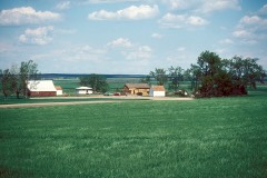 | Ludwig and Christina Welk Homestead | building | 1993 | 93001102 |
 | Willows Hotel | building | 1996 | 96000522 |
Every wildfire the federal occurrence database records inside this county: 87 of them, burning about 4,835 acres. 9 started naturally and 2 were recorded as arson. Each settlement page carries the fires within five miles of it.
| Reported cause | Fires |
|---|---|
| Equipment and vehicle use | 27 |
| Missing data/not specified/undetermined | 18 |
| Debris and open burning | 18 |
| Natural | 9 |
| Misuse of fire by a minor | 4 |
| Fireworks | 4 |
| Power generation/transmission/distribution | 3 |
| Arson/incendiarism | 2 |
| Smoking | 1 |
| Recreation and ceremony | 1 |
The five largest, by the area the report gives. None of them was recorded as arson.
| Date | Cause | Size | Reported by | Name on the report |
|---|---|---|---|---|
| 20 June 2002 | Natural | 2,554 acres | Long Lake National Wildlife Refuge | BISRURAL 2 |
| 3 November 2011 | Missing data/not specified/undetermined | 1,200 acres | North Dakota State Forest Service | MEIER RANCH |
| 21 June 2006 | Missing data/not specified/undetermined | 600 acres | North Dakota Dispatch Center | EMMONS |
| 14 March 2016 | Debris and open burning | 150 acres | North Dakota State Forest Service | WACHTER FIRE # 1 |
| 22 April 2016 | Debris and open burning | 40 acres | North Dakota State Forest Service | REBENITSCH FIRE |
| 23 February 2016 | Equipment and vehicle use | 30 acres | North Dakota State Forest Service | SOUTH FORK FIRE |
| 17 October 2017 | Equipment and vehicle use | 25 acres | North Dakota State Forest Service | BOEHM GRASS FIRE |
| 15 March 2016 | Debris and open burning | 20 acres | North Dakota State Forest Service | WACHTER FIRE # 2 |
Every settlement page carries the fires within five miles of it - see the settlement index below.
The NOAA Storm Events Database holds 318 reports for this county, causing no deaths, 3 injuries and about $8,930,780 in recorded property damage. Each settlement page carries the reports that name it.
| Kind of event | Reports |
|---|---|
| Hail | 141 |
| Thunderstorm Wind | 120 |
| Tornado | 42 |
| Flash Flood | 6 |
| Funnel Cloud | 4 |
| Flood | 2 |
| Heavy Rain | 2 |
| Wildfire | 1 |
The most serious of them, by death, then injury, then recorded damage. The accounts are quoted exactly as the forecast office filed them.
| When | Event | Place named | Harm | What the report says |
|---|---|---|---|---|
| July 1976 | Tornado (F0) | not stated | 2 hurt | no account filed |
| June 2001 | Tornado (F1) | Hazelton | 1 hurt | Drivers along Highway 83 witness a vehicle drive into the path of the tornado. The vehicle was thrown into the ditch injuring the driver. Other damage by the tornado includes four power lines down along highway 83. Tops of evergreen tree's snapped off. The damage was also verified by a storm chase team. |
| August 1996 | Tornado (F0) | Linton | $750,000 | no account filed |
| March 2009 | Flood | Hazelton | $748,000 | Beaver creek at Linton flooded due to snow melt from heavy rain, and ice jams just west of Linton. Overland flooding damaged state, county and township roads. Seventy three homes were flooded. Flooding continued into April. |
| June 2021 | Flash Flood | Kintyre | $600,000 | Over five inches of rain was measured over parts of west-central into northeast Emmons County, with over seven inches indicated on radar, leading to flash flooding. In Hazelton, streets and yards flooded. Near Braddock, a mail delivery vehicle was swept away in flood waters, along with another vehicle. Multiple rural roads were heavily damaged. |
| July 2010 | Hail | Linton | $500,000 | Damage was sustained to area homes and vehicles. Crop damage was reported to be severe across central Emmons County. |
| July 2008 | Hail | Linton | $500,000 | Very significant damage occurred in the city of Linton. Two automobile dealerships reported $110,000 damage total. Nearly every vehicle parked outside had some type of damage, either dents or cracked windows. Damage to structures, mainly roofs, eave troughs, and vents, was widespread throughout the city. Outside of town damage was reported to farm houses, outbuildings, and horse trailers. The hail swath was about five and a half miles long and a mile wide, right through Linton. Crop damage was minimal in comparison as the storm hailed itself out about 4 miles east of town. Little crop land was affected. |
| September 2025 | Tornado (EF2) | Linton | $400,000 | Initial damage near the start of the tornado consisted of crop damage. The tornado then travelled northwest to a farmstead where it dented in the south facing side of a large, mostly empty grain bin. It then proceeded to destroy an 80 by 124 foot pole barn to the north. Inside the barn, farm equipment was damaged including a combine which had the south facing door to barn resting on it. Debris was scattered in all directions and several hundred feet away. Large pieces of board from the destroyed building were embedded in the ground including part of a rafter. There was limited tree damage to the row of trees to the north of this property. The tornado then progressed to the north before dissipating. Based on the damage done this tornado was rated EF-2, and from that wind speeds were estimated to be around 120 mph. |
| June 2011 | Thunderstorm Wind | Kintyre | $350,000 | Strong thunderstorm winds resulted in a pole barn being destroyed and a stock trailer rolled approximately 200 feet. Also on the farmstead, a garage roof was ripped off, a well house was totaled, a grain bin blown over, and windows were blown out of vehicles. |
| June 2025 | Tornado (EF1) | Temvik | $300,000 | This was the first of two tornadoes that struck the Temvik area. The tornado formed in an open field just to the southwest of a farmstead before moving northeast. The tornado then crossed a road and knocked over a power pole before impacting the farmstead. The home suffered damage to the siding and roof, along with a slight shift in the foundation. The tornado also destroyed a few outbuildings anchored with chains, and significantly damaged a large quonset building. In addition, a large stainless-steel flatbed trailer was tossed around 250 yards, and another smaller trailer was tossed around 350 yards before landing in a grove of trees. The tornado continued to move to the northeast, snapping some hardwood trees in a shelterbelt before lifting. Based on the damage done this tornado was rated EF-1, and from that wind speeds were estimated to be around 110 mph. |
| July 2018 | Thunderstorm Wind | Kintyre | $300,000 | Widespread damage occurred in the Kintyre area. A farm house about one mile northeast of town was extensively damaged. In the farmyard, three buildings sustained major damage with many broken trees. In town, many trees were damaged, with many evergreen trees snapped off about ten feet off the ground. Other trees were uprooted. |
| April 2009 | Flood | Hazelton | $300,000 | A second round of overland flooding and flooding along Beaver Creek resulted in additional damages to several county and local roads, and to numerous homes in and around Linton. |
| June 2013 | Hail | Linton | $250,000 | The large hail caused home, car, and tree damage in the city of Linton, and crop damage outside of town. |
| May 1964 | Tornado (F2) | not stated | $250,000 | no account filed |
| May 1953 | Tornado (F5) | not stated | $250,000 | no account filed |
| June 2025 | Tornado (EF2) | Temvik | $200,000 | This is the second of two tornadoes to impact the Temvik area. The tornado developed just to the south of a farmstead and moved north, impacting the farmstead. The tornado picked up a large horse trailer, and tossed it approximately 150 yards into a tree. The tornado then destroyed a new large metal workshop, a small garage, and a large wooden barn. The workshop and garage had both been anchored into concrete slabs. The tornado also impacted the house by blowing off a well-built front porch and causing significant roof covering damage. Multiple hardwood and softwood trees were severely damaged with some snapped. The tornado then tracked slowly to the north through open fields before dissipating. Based on the damage done this tornado was rated EF-2, and from that wind speeds were estimated to be around 120 mph. |
| July 2018 | Thunderstorm Wind | Hazelton | $200,000 | Extensive wind damage occurred from Badger Bay to just north of the Hazelton Recreational Area. At Badger Bay, a 5th wheel camper was tipped over. About five miles north of Badger Bay an unoccupied mobile home was tipped over, rolled, and destroyed. To the north of Hazelton Recreation Area, a pole barn and several smaller sheds were destroyed. Debris was blown 1/4 mile to the northeast. |
| August 2016 | Thunderstorm Wind | Strasburg | $200,000 | A storage building was destroyed and two others were severely damaged. A well built hardware store awning was damaged by a falling tree. Several trees were uprooted, and tree limbs around 13 inches in diameter were snapped. |
| June 2011 | Thunderstorm Wind | Kintyre | $200,000 | Strong thunderstorm winds resulted in a storage shelter destroyed at the Kintyre Centennial Park. Also damaged was a 50,000 bushel bin at the South Central Grain elevator in Kintyre. |
| August 2006 | Thunderstorm Wind | Linton | $200,000 | A farm was heavily damaged 14 miles to the southwest of Linton. On this farm a wood grainery was heavily damaged, a roof was torn from an outbuilding, and a wood fence was damaged. Another farm was damaged 23 miles southwest of Linton. On this particular farm a 60X80 foot pole barn was demolished, roof damage was sustained to a farm house and outbuilding, a horse trailer was destroyed, and another outbuilding was moved 4 inches off of its foundation. |
| July 1998 | Thunderstorm Wind | Strasburg | $200,000 | Downburst winds of 87 kts (100 mph) caused widespread damage to numerous weak or high profile buildings in parts of southeast Emmons county. Even though there was heavy property damage, there were no fatalities or injuries. No one reported a tornado although there were unconfirmed reports of funnel clouds. Two trailer houses near Strasburg were destroyed as well as grain bins, pole barns, and farm machinery. The county emergency manager reported no damage in the city of Strasburg, just heavy rain and gusty winds. Monetary damage estimates are likely underestimated. |
| July 2011 | Thunderstorm Wind | Hazelton | $150,000 | Winds were measured with a home anemometer near Hazelton. Extensive tree damage occurred in Hazelton, with three to six inch in diameter branches blown off of trees. A gas station on the west side of Hazelton sustained damage to the canopy over the gas pumps. |
| October 1997 | Thunderstorm Wind | Linton | $150,000 | strong thunderstorm winds Cattail Bay,a popular camping area. A mobile home was picked up off of its foundation, lifted over a van, and dropped 40 feet away. Van and a boat in the driveway were flipped over. Numerous other campers were flipped over or onto their sides. Nearby pole bard flattened and a 10,000 bushel grain bin toppled. Property damage amount estimated. |
| June 1999 | Hail | Linton | $130,000 | Percent of yield losses for 35,200 acres of crops ranged from 10 to 45 percent. |
| June 2011 | Thunderstorm Wind | Kintyre | $125,000 | Strong thunderstorm winds resulted in a historic barn destroyed near Kintyre. |
| June 2016 | Thunderstorm Wind | Hazelton Arpt | $100,000 | The strong wind gusts snapped tree tops and blew them 100 feet over a house and into the back yard. An eight foot by 14 foot greenhouse blew away. Wind gusts also blew over a portable creep feeder at the Hazelton elevator and broke its axle. |
| August 2016 | Thunderstorm Wind | Linton | $100,000 | Multiple trees were uprooted and tree limbs around 5 inches in diameter were snapped. |
| June 2011 | Thunderstorm Wind | Linton Muni Arpt | $100,000 | One hanger and two planes were destroyed at the Linton Airport. |
| July 2018 | Thunderstorm Wind | Westfield | $90,000 | The Bakker School near Westfield had its roof torn off, including some rafters. Sections of the roof blew across the road. The roof appears to have been added onto the structure which may have originally had a flat roof. The interior of the school suffered water damage after the roof was torn off. |
| May 2010 | Thunderstorm Wind | Linton | $90,000 | Strong winds associated with a severe thunderstorm resulted in moderate damage within the city of Linton. Parts of the roof were torn off of the Linton fire hall and several trees were blown down. Reports of damage to other roofs in Linton and several power lines blown down were also received. |
| June 2013 | Hail | Linton | $75,000 | Hail ranged from nickel to golf ball sized. |
| July 2008 | Hail | Dana | $65,000 | A severe thunderstorm left a hail damage swath through central Emmons County Saturday evening. The largest stones were two inches in diameter. Damage was reported to homes and crops. |
| June 2025 | Thunderstorm Wind | Hazelton | $50,000 | Several branches and a few trees down. Power also was lost. |
| August 2019 | Hail | Westfield | $50,000 | Extensive crop and building damage. |
| May 2010 | Thunderstorm Wind | Linton | $50,000 | Severe thunderstorm wind gusts resulted in damage to a roof of an old elementary school and several large trees blown over in Linton. |
| July 1998 | Hail | Hague | $50,000 | Damage was surveyed by the Sheriff and a deputy. Most of the damage was due to wind driven hail. Very little damage due to wind alone. The power went out in Hague near 6 PM CDT and their was minor damage to the Hague Grain Elevator. |
| August 1993 | Thunderstorm Wind | Linton | $50,000 | The wind blew bales of hay 0.25 mile away. |
| July 2016 | Hail | Linton | $50,000 | no account filed |
| May 1996 | Thunderstorm Wind | Cannonball | $50,000 | no account filed |
| July 2014 | Thunderstorm Wind | Hazelton | $45,000 | Strong thunderstorm winds damaged a roof and deck, and destroyed a shed. |
| July 2019 | Flash Flood | Westfield | $40,000 | Between five and six inches of rain fell over parts of southern Emmons County. This led to deep water running over sections of U.S. Highway 83, blocking the highway. There were wash outs on some county roads. |
| June 2012 | Thunderstorm Wind | Linton | $35,000 | The strong winds blew down seven power poles. |
| June 2011 | Thunderstorm Wind | Linton | $35,000 | Tree and some minor structure damage was reported in Linton. |
| July 2011 | Thunderstorm Wind | Linton | $35,000 | The strong thunderstorm winds destroyed a cabin at Beaver Bay. |
| June 2008 | Thunderstorm Wind | Braddock | $35,000 | Thunderstorm wind gusts up to 70 miles per hour caused damage to a pole barn and minor damage to a house roof. |
| July 2011 | Tornado (EF0) | Linton | $30,000 | This tornado touched down in the open country. Although there were no reports of structural damage associated with this tornado, there were reports of shelterbelt tree and crop damage at two farmsteads. Tree damage corresponded to high end EF0 on the Enhanced Fujita Scale and from that it was determined that wind speeds were around 85 miles per hour. |
| June 2013 | Flash Flood | Temvik | $25,000 | Deep water was flowing over highway 34 about 11 miles east of Hazelton, and county roads in this area were under deep water. There were rain reports of nearly three inches. |
| July 2011 | Thunderstorm Wind | Hazelton Arpt | $25,000 | Minor wind damage occurred at a farmstead. Shingles were blown off of a trailer home, and a small building was blown over. |
| July 1996 | Tornado (F0) | Strasburg | $25,000 | no account filed |
| August 1988 | Tornado (F1) | not stated | $25,000 | no account filed |
| August 1988 | Tornado (F1) | not stated | $25,000 | no account filed |
| June 1976 | Tornado (F0) | not stated | $25,000 | no account filed |
| June 1976 | Tornado (F1) | not stated | $25,000 | no account filed |
| May 1974 | Tornado (F2) | not stated | $25,000 | no account filed |
| August 1974 | Tornado (F2) | not stated | $25,000 | no account filed |
| August 1967 | Tornado | not stated | $25,000 | no account filed |
| July 1955 | Tornado (F3) | not stated | $25,000 | no account filed |
| May 2010 | Thunderstorm Wind | Strasburg | $20,000 | Twenty inch in diameter trees were reported blown down from severe thunderstorm wind gusts. |
| June 2010 | Thunderstorm Wind | Hazelton | $20,000 | The intense thunderstorm winds resulted in damage to tree branches in Hazelton, along with minor damage to one home. |
| July 2010 | Hail | Hazelton | $20,000 | Broken windows resulted from the large hail. |
The Survey's mineral resources record lists 2 workings inside this county. None of them still produces: all are closed or unrecorded. Each settlement page carries the workings within five miles of it.
| Commodity | Workings |
|---|---|
| Clay | 1 |
| Stone | 1 |
The least common of them first, because a county's hundredth gravel pit says nothing its first ten did not.
Named settlements recorded in the Geographic Names Information System, each with the topographic sheets covering it. Villages, hamlets and abandoned places alike. Each is shown with the nearest named watercourse or landform and the survey quadrangle it falls on.
South Emmons unorganized territory · 58573 · Near Lone Butte · Grassna quadrangle
5 sheets, 1954 to 1980
South Emmons unorganized territory · 58542 · Senger Lake South quadrangle
5 sheets, 1954 to 1980
North Emmons unorganized territory · 58544 · On Badger Creek · Fort Rice quadrangle
8 sheets, 1907 to 1979
North Emmons unorganized territory · 58552 · On Temvik Butte · Temvik quadrangle
5 sheets, 1954 to 1980