 Block
From the record
3 National Register listings published here.
Sources: the National Register database, National Park Service
18 topographic sheets cover 13 settlements here, and 3 properties are on the National Register of Historic Places.
3 National Register listings published here.
Sources: the National Register database, National Park Service
Every property in this county listed on the National Register of Historic Places, with the year it was listed and the federal nomination document.
| Photograph | Property | Type | Listed | Reference |
|---|---|---|---|---|
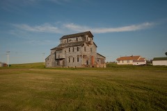 | Carson Roller Mill | building | 1980 | 80002915 |
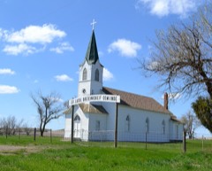 | Evangelisch Lutheraner Dreieinigkeit Gemeinde | building | 2009 | 09000530 |
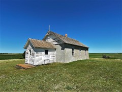 | Hope Lutheran Church | building | 1992 | 91001924 |
Every wildfire the federal occurrence database records inside this county: 122 of them, burning about 4,774 acres. 19 started naturally and 7 were recorded as arson. Each settlement page carries the fires within five miles of it.
| Reported cause | Fires |
|---|---|
| Equipment and vehicle use | 55 |
| Missing data/not specified/undetermined | 22 |
| Natural | 19 |
| Debris and open burning | 11 |
| Arson/incendiarism | 7 |
| Smoking | 5 |
| Power generation/transmission/distribution | 2 |
| Other causes | 1 |
The five largest, by the area the report gives. None of them was recorded as arson.
| Date | Cause | Size | Reported by | Name on the report |
|---|---|---|---|---|
| 3 March 2008 | Missing data/not specified/undetermined | 2,000 acres | North Dakota State Forest Service | WOODBURY |
| 17 August 2016 | Equipment and vehicle use | 425 acres | North Dakota State Forest Service | GRASS FIRE |
| 23 August 2005 | Equipment and vehicle use | 300 acres | North Dakota State Forest Service | not named |
| 6 August 2012 | Equipment and vehicle use | 200 acres | North Dakota State Forest Service | WOLLMAN |
| 20 August 2018 | Equipment and vehicle use | 180 acres | North Dakota State Forest Service | 2018-807 |
| 31 March 2020 | Missing data/not specified/undetermined | 120 acres | North Dakota State Forest Service | DARREN PETERSON |
| 30 March 2016 | Equipment and vehicle use | 115 acres | North Dakota State Forest Service | LARRY BRAUN |
| 23 July 2017 | Equipment and vehicle use | 100 acres | North Dakota State Forest Service | MUGGLI |
Every settlement page carries the fires within five miles of it - see the settlement index below.
The NOAA Storm Events Database holds 324 reports for this county, causing 5 deaths, 40 injuries and about $11,441,780 in recorded property damage. Each settlement page carries the reports that name it.
| Kind of event | Reports |
|---|---|
| Hail | 187 |
| Thunderstorm Wind | 90 |
| Tornado | 27 |
| Flash Flood | 5 |
| Funnel Cloud | 5 |
| Flood | 4 |
| Heavy Rain | 3 |
| Lightning | 2 |
| Wildfire | 1 |
The most serious of them, by death, then injury, then recorded damage. The accounts are quoted exactly as the forecast office filed them.
| When | Event | Place named | Harm | What the report says |
|---|---|---|---|---|
| July 1978 | Tornado (F4) | not stated | 5 killed, 35 hurt, $2,500,000 | no account filed |
| July 2014 | Hail | Elgin | 3 hurt, $750,000 | There were numerous reports of golf ball to over baseball size hail across the Lake Tschida and Heart Butte Dam area resulting in significant damage to vehicles, campers, and trailer homes in the recreational area. In addition three people received non-life threatening head injuries from the hail. They were treated at the scene. |
| June 1976 | Tornado (F1) | not stated | 1 hurt, $25,000 | no account filed |
| June 1997 | Lightning | 3 S Elgin | 1 hurt | An 11 year old boy was struck by lightning while fishing with his father. He had holes burned into his shirt and was knocked unconscience. The boy also quit breathing, but his father and a friend used CPR to get the boy breathing again. The boy suffered some ear damage. |
| July 2010 | Hail | Elgin | $2,000,000 | This was the second wave of very large hail to hit Elgin during this episode. Homes throughout the city experienced broken windows, damaged siding, and damaged shingles. Vehicles sustained heavy damaged as well. |
| May 1996 | Thunderstorm Wind | Raleigh | $1,500,000 | no account filed |
| July 2010 | Hail | New Leipzig | $1,000,000 | This was the second wave of very large hail to hit New Leipzig during this episode. Homes throughout the city experienced broken windows, damaged siding, and damaged shingles. Vehicles sustained heavy damaged as well. |
| June 2019 | Hail | Elgin Muni Arpt | $550,000 | A supercell thunderstorm passed over northern Grant County, producing very large hail up to three inches in diameter. Numerous farmers and ranchers sustained crop and property loss. Damage reports include a collapsed roof on a pole barn, holes punched in siding and roofs, extensive loss of structural and vehicle glass, extensive vehicle damage, tractor and farm equipment damage, and widespread crop losses. |
| July 2011 | Thunderstorm Wind | New Leipzig | $500,000 | Large trees were blown down in the city of Carson. Structural damage also occurred to many local buildings in the city of Carson and surrounding farmsteads. |
| March 2009 | Flood | Elgin | $342,000 | The Cannonball River caused extensive flooding due to rain, snow melt, and ice jams. Overland flooding damaged state, county and township roads. Nineteen homes were flooded. Flooding continued into April. |
| July 2018 | Hail | Elgin | $250,000 | Significant damage to vehicles and roofs occurred in the city of Elgin. |
| June 1986 | Tornado (F1) | not stated | $250,000 | no account filed |
| June 2011 | Tornado (EF2) | New Leipzig | $200,000 | A National Weather Service storm survey confirmed that an EF2 tornado on the Enhanced Fujita Scale touched down eight miles south-southwest of Elgin, then moved northeast before lifting 3 miles south-southeast of Elgin. No fewer than four farmsteads were damaged along the path of the tornado. The worst damage occurred six miles south-southwest of Elgin, where the tornado was nearly one half of a mile wide, damaging every building on a farmstead and completely destroying the smaller buildings. Damage also occurred to trees, vehicles, and power poles. The damage surveyed corresponded to EF2 on the Enhanced Fujita Scale. From that it was determined that wind speeds were on the order of around 120 miles per hour.||Farther north-northeast, three other farmsteads sustained tornado damage. Damage on the first two farmsteads north-northeast of the worst damage was consistent with an EF1 tornado. The farthest north farmstead had damage consistent with an EF0 tornado. ||There were no injuries or fatalities with this tornado. |
| June 2021 | Flash Flood | Raleigh | $150,000 | Over five inches of rain fell over southeastern Grand County. Flood waters washed out 75th Street near Freda, which is east of the community of Raleigh. |
| June 2025 | Thunderstorm Wind | Elgin | $100,000 | On the north side of Lake Tschida a camper was tipped on its side, a pontoon was completely flipped, trees were down, and a wooden swing set was tipped over. |
| April 2009 | Flood | Elgin | $100,000 | Additional overland flooding and flooding on the Cannonball River resulted in further flood damage. Flooding in April was less severe than March due to no ice jams. |
| July 2018 | Hail | Leith | $75,000 | Large hail occurred for an extended period in the community of Leith, causing damage to homes and vehicles. |
| July 2017 | Thunderstorm Wind | Elgin | $75,000 | Shingles were blown off about one-quarter of a roof on a home. Some plywood was also stripped from the roof. Multiple branches were down around the city of Elgin. |
| June 2011 | Flash Flood | Elgin | $75,000 | Very heavy rainfall contributed to flash flooding along Antelope Creek near North Dakota Highway 49. A storm survey crew observed high water marks near the top of barbed wire fences in this area. The Carson Press newspaper reported damage was sustained to rural roads north of Elgin. |
| July 2010 | Lightning | Elgin | $65,000 | A lightning strike caused a house fire in Elgin. The lightning bolt struck the chimney of the house, traveling into the basement starting a fire in the electrical wiring on all three levels of the home. When arriving on scene, fire officials reported that a metal antenna on the chimney of the home was glowing bright orange. No injuries or fatalities occurred. The home was determined to be a complete loss. |
| July 2007 | Thunderstorm Wind | New Leipzig | $65,000 | Newspaper reports New Leipzig sustained damage from storm. Several large trees uprooted along with some damage to homes. |
| May 2010 | Thunderstorm Wind | New Leipzig | $60,000 | Straight line winds associated with a severe thunderstorm destroyed two outbuildings on a farm. The wind speed was estimated based on the damaged observed during a storm survey. |
| June 2025 | Thunderstorm Wind | Elgin | $50,000 | A large outbuilding had most of its roof panels blown off. |
| July 2020 | Hail | Elgin Muni Arpt | $50,000 | Windows were broken on the north and west side of the home and out-buildings. Metal sheds were dented. Corn crop was shredded and destroyed. |
| August 2017 | Hail | New Leipzig | $50,000 | Several law enforcement vehicles were damaged by the large hail. |
| June 2011 | Flash Flood | New Leipzig | $50,000 | Very heavy rainfall contributed to flash flooding in and around New Leipzig. Streets quickly became flooded, and sewage backup was reported in basements. |
| July 2010 | Hail | Freda | $50,000 | Strong thunderstorm winds combined with the large hail resulting in crop damage and all west side windows on a home broken. |
| July 2015 | Hail | New Leipzig | $50,000 | no account filed |
| May 1996 | Thunderstorm Wind | Elgin | $50,000 | no account filed |
| July 2010 | Hail | Raleigh | $45,000 | The large hail resulted in damaged vehicles at the Prairie Learning Center in Saint Gertrude. |
| June 2024 | Hail | Elgin | $40,000 | Hail fell at a campground at Lake Tschida causing damage to campers. |
| June 2022 | Hail | Shields | $30,000 | Crops were damaged by the hail. In addition, house windows were damaged, along with the windows and siding on a camper. |
| May 2010 | Thunderstorm Wind | Carson | $30,000 | Strong straight line winds associated with a severe thunderstorm resulted in several large evergreen and cottonwood trees to become uprooted or were blown over. The wind speed was estimated from a storm survey. |
| July 2007 | Thunderstorm Wind | Carson | $30,000 | Newspaper reports farmstead sustained damage from storm 25 miles south of Carson. Crop damage from hail and winds and several grain bins ripped apart. |
| July 2020 | Hail | Elgin | $25,000 | Multiple windows were broken on the barn and on garage doors. |
| August 2018 | Hail | Lark | $25,000 | The house roof was damaged. Some tree branches were broken by the winds that accompanied the hail. Corn leaves were shredded. |
| July 2010 | Hail | Raleigh | $25,000 | Strong thunderstorm winds accompanied the large hail, and resulted in windows on the west side of a house broken. |
| June 2007 | Flood | Leith | $25,000 | In the area around Leith trained spotters reported minor flooding. Water was running over low spots in roads. |
| August 1983 | Tornado (F1) | not stated | $25,000 | no account filed |
| June 1966 | Tornado (F1) | not stated | $25,000 | no account filed |
| June 2025 | Thunderstorm Wind | Elgin Muni Arpt | $20,000 | Several large pine trees were uprooted or broken down at the Heart Butte Boy Scout Camp. |
| August 2017 | Hail | Raleigh | $20,000 | Vehicles were dented. |
| August 2017 | Hail | New Leipzig | $20,000 | There was damage to vehicles and roofs. |
| July 2007 | Hail | Elgin | $20,000 | Newspaper reports farmstead sustained damage from storm 6 miles south of Elgin. Major crop damage from hail and winds, trees broken/uprooted, and hail damage to home. |
| July 2016 | Hail | Shields | $20,000 | no account filed |
| July 2010 | Hail | Brisbane | $15,000 | The large hail resulted in two skylights and one window broken. |
| July 2008 | Thunderstorm Wind | New Leipzig | $8,000 | A two foot in diameter tree was blown down and there was roof damage. |
| July 2024 | Thunderstorm Wind | Lark | $5,000 | The wind tore some shingles off of the roof, and a cottonwood tree had some branches broken off and leaves stripped. |
| June 1965 | Tornado | not stated | $2,500 | no account filed |
| July 2023 | Hail | Brisbane | $2,000 | A large garden was destroyed. |
| September 2023 | Thunderstorm Wind | Carson | $1,000 | A power line was blown down. |
| July 2022 | Hail | Raleigh | $1,000 | Plants were damaged around the house. |
| June 1975 | Tornado (F4) | not stated | $250 | no account filed |
| July 1983 | Tornado (F0) | not stated | $30 | no account filed |
| July 2024 | Thunderstorm Wind | Brisbane | - | Thunderstorm wind gusts were estimated by a trained spotter. |
| June 2021 | Thunderstorm Wind | Elgin | - | Law Enforcement reported thunderstorm wind gusts of 60 mph. |
| July 2020 | Thunderstorm Wind | Elgin Muni Arpt | - | Thunderstorm wind gusts were estimated by a COOP Observer. |
| July 2020 | Thunderstorm Wind | Elgin | - | Thunderstorm wind gusts were estimated by the public. |
| June 2020 | Thunderstorm Wind | Elgin | - | Law enforcement estimated thunderstorm wind gusts of 60 mph. |
| June 2020 | Thunderstorm Wind | Elgin | - | Law enforcement estimated thunderstorm wind gusts of 60 mph. |
Named settlements recorded in the Geographic Names Information System, each with the topographic sheets covering it. Villages, hamlets and abandoned places alike. Each is shown with the nearest named watercourse or landform and the survey quadrangle it falls on.
East Grant unorganized territory · 58529 · On Carson Hill · Carson quadrangle
5 sheets, 1954 to 1980
West Grant unorganized territory · 58533 · On Heart Butte Creek · Lake Tschida East quadrangle
7 sheets, 1938 to 1980
West Grant unorganized territory · 58533 · Lake Tschida East quadrangle
7 sheets, 1938 to 1980