 Block
From the record
4 National Register listings published here.
Sources: the National Register database, National Park Service
25 topographic sheets cover 9 settlements here, and 4 properties are on the National Register of Historic Places.
4 National Register listings published here.
Sources: the National Register database, National Park Service
Every property in this county listed on the National Register of Historic Places, with the year it was listed and the federal nomination document.
| Photograph | Property | Type | Listed | Reference |
|---|---|---|---|---|
 | Crystal Springs Fountain | object | 2010 | 10000999 |
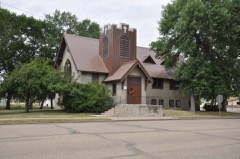 | First Presbyterian Church of Steele | building | 2004 | 04000467 |
 | Kidder County Courthouse | building | 1985 | 85002985 |
 | Robinson Hall | building | 2018 | 100002253 |
Every wildfire the federal occurrence database records inside this county: 20 of them, burning about 3,626 acres. 1 started naturally and 2 were recorded as arson. Each settlement page carries the fires within five miles of it.
| Reported cause | Fires |
|---|---|
| Missing data/not specified/undetermined | 7 |
| Equipment and vehicle use | 4 |
| Debris and open burning | 3 |
| Recreation and ceremony | 2 |
| Arson/incendiarism | 2 |
| Railroad operations and maintenance | 1 |
| Natural | 1 |
The five largest, by the area the report gives. None of them was recorded as arson.
| Date | Cause | Size | Reported by | Name on the report |
|---|---|---|---|---|
| 17 August 2003 | Missing data/not specified/undetermined | 3,000 acres | North Dakota State Forest Service | DAWSON |
| 29 March 2016 | Debris and open burning | 320 acres | North Dakota State Forest Service | CENTRAL GRASSLANDS STREETER STATION |
| 3 May 2019 | Missing data/not specified/undetermined | 100 acres | North Dakota State Forest Service | DAVE SHOCKMAN FIRE |
| 6 April 1998 | Missing data/not specified/undetermined | 55 acres | Chase Lake Prairie Project Wetland Management District | CSPRINGS |
| 27 April 1997 | Recreation and ceremony | 39 acres | Slade National Wildlife Refuge | SLADE1 |
| 24 September 2015 | Missing data/not specified/undetermined | 30 acres | North Dakota State Forest Service | NORDGAARD FIRE |
| 26 May 2004 | Recreation and ceremony | 28 acres | Long Lake National Wildlife Refuge | SLADE 1 |
| 9 April 2017 | Missing data/not specified/undetermined | 15 acres | North Dakota State Forest Service | TRAUTMANN SLOUGH |
Every settlement page carries the fires within five miles of it - see the settlement index below.
The NOAA Storm Events Database holds 255 reports for this county, causing no deaths, 1 injury and about $12,150,060 in recorded property damage. Each settlement page carries the reports that name it.
| Kind of event | Reports |
|---|---|
| Hail | 130 |
| Thunderstorm Wind | 86 |
| Tornado | 20 |
| Funnel Cloud | 9 |
| Flash Flood | 5 |
| Heavy Rain | 3 |
| Flood | 2 |
The most serious of them, by death, then injury, then recorded damage. The accounts are quoted exactly as the forecast office filed them.
| When | Event | Place named | Harm | What the report says |
|---|---|---|---|---|
| June 1988 | Tornado (F1) | not stated | 1 hurt, $250,000 | no account filed |
| June 1999 | Thunderstorm Wind | Tuttle | $5,000,000 | Damage to 200 farm buildings. fifty one metal power line towers collapsed. twenty two irrigation system destroyed. |
| April 2009 | Flood | Tuttle | $1,300,000 | Heavy overland flooding from snowmelt damaged two homes and numerous state, county, and local roads. |
| July 2001 | Tornado (F2) | Lake Williams | $1,000,000 | Tornado reported to be 1/2 mile wide at times. The tornado remained in open country before entering into Stutsman county. Damage was contained to metal and double poled high power line towers. A farmstead in the path of the tornado sustained $200,000 in damage. (see Stutsman county report on same tornado.) |
| June 2025 | Tornado (EF1) | Tappen | $750,000 | This is the first event entry for one tornado that passed through two counties, Kidder and Stutsman. This Quasi-Linear Convective System (QLCS) tornado started northwest of Crystal Springs in Kidder County and moved to the east-southeast. The tornado then shifted towards the east-northeast near the Stutsman County line, and continued into Stutsman County before it lifted to the north-northwest of Medina. Near the point of touchdown, a machine shed was completely destroyed, with the roof laying in a pasture about 350 feet away. Approximately five miles to the south-southeast, two additional farmsteads in close proximity were struck. The first one had an older barn along with a pole barn completely destroyed. The second farmstead had an older barn collapse, and an empty 18 foot diameter grain bin lifted and moved approximately 400 feet. Along the grain bin's path it hit a building, two vehicles, and a camper before it came to rest in front of the collapsed barn. Shortly thereafter, the tornado turned north-northeast and then struck another farmstead approximately 3 miles away. At this farm, a quonset building was moved off its foundation, and boards from the inside were sucked out and laying a few feet away. Additional buildings were damaged, with debris from a children's play house blown a half mile away and a picnic table blown a quarter mile. Mature trees were snapped and fully de-leafed with numerous large branches broken off. The tornado then continued to the north-northeast and twisted multiple smaller metal high-voltage power towers. Further to the north-northeast before it lifted, the tornado struck another farmstead where a farm outbuilding was destroyed, the shingles, siding, and gutters were severely damaged on a house, and trees were snapped about half way up. Based on the damage done this tornado was rated EF-1, and from that wind speeds were estimated to be around 110 mph. |
| August 2024 | Tornado (EF1) | Steele | $600,000 | The tornado touched down in an oats field to the east-southeast of Steele, with the plants twisted and downed in multiple directions. Approximately one mile east of |Steele the tornado crossed the path of a stopped train and about 40 empty railroad cars were knocked off the tracks. The tracks ran from west to east, with some cars falling north, and some falling south. In addition, near the derailed cars, a grove of hardwood trees suffered damage, with a few trees uprooted. The tornado then lifted one mile northeast of Steele. Based on the damage done this tornado was rated high-end EF-1, and from that wind speeds were estimated to be around 110 mph. |
| June 1999 | Thunderstorm Wind | Pettibone | $400,000 | Widespread structure and tree damage. |
| June 1999 | Tornado (F2) | Steele | $400,000 | no account filed |
| June 2021 | Flash Flood | Steele Muni Arpt | $350,000 | Over four inches of rain was measured over various parts of southwest Kidder County, with radar estimates of over six inches. In the city of Steele, many roads were under water. Over rural portions of the county affected by the heavy rain, multiple gravel road and culvert washouts occurred. |
| September 2023 | Thunderstorm Wind | Haynes | $300,000 | A small Park Model mobile, which was on blocks and anchored down, was completely destroyed, with the undercarriage separating from the unit, though the deck remained in its spot with a grill still on it. A 55 gallon barrel of steel scrap was blown over and rolled. Multiple three foot diameter cottonwood trees were damaged, with some uprooted and a few older ones snapped. About one-quarter mile to the east of this location a grain bin was blown across a road, and a shop wall was blown out. Windbreak panels were toppled, with one tossed and flipped over. All damage was blown toward the north and east, the direction the storm was moving. |
| May 1996 | Thunderstorm Wind | Steele | $300,000 | no account filed |
| May 2010 | Tornado (EF1) | Tuttle | $250,000 | The public reported damage to farms in the area. Most of the damage was caused by thunderstorm winds, however, the damage in one area was descriptive of a tornado. The farmer with the worst damage described objects scattered about in east, north, northwest, and west directions. His description of the debris field indicated that this was likely a tornado. Vehicles were damaged, along with garages, stalls, and barns. Trees were uprooted. One garage was blown to the west, while animal feeders were blown to the east. Based on the description of damage it was determined that this was an EF1 tornado. From that the estimated wind speed was around 100 mph. |
| August 2025 | Thunderstorm Wind | Pettibone | $200,000 | Two large grain bins became dislodged from their base and rolled to the west. One ended up over the nearby county road, and the other ended up wrapped around the side of a house. |
| July 2014 | Thunderstorm Wind | Dawson | $175,000 | Numerous very large trees were down around Lake Isabel, and a pontoon was flipped over. In one case a tree fell onto a lake home and crashed through the roof. |
| June 2014 | Thunderstorm Wind | Dawson | $150,000 | A damage survey assessed that strong thunderstorm winds moved from southeast to northwest over Lake Isabel. The worst damage occurred on the northwest side of the lake. Damage included uprooted and snapped trees, roofs torn from homes, damaged decks, and structures damaged from falling trees. |
| July 2023 | Thunderstorm Wind | Steele | $100,000 | Multiple large trees branches were down throughout the community of Steele, with three trees uprooted. Some of the branches were large enough to block roads. Power was also out throughout the town. |
| August 1997 | Hail | Steele | $100,000 | hail ranging in size from 1.75 inches to 4.50 inches fell in a swath from Steele to Lake Isabel. Numerous tree and property damage reported. |
| May 2010 | Thunderstorm Wind | Tuttle | $55,000 | Severe thunderstorm wind gusts damaged a shed and destroyed a garage. |
| June 2009 | Flash Flood | Tuttle | $50,000 | Thunderstorms with heavy rainfall continuously moved through western Kidder County for several hours during the evening of the 15th. Doppler radar estimated rainfall amounts ranged from four to seven inches across the warned area. Water was reported to be a foot deep blocking passage over some roads. |
| August 2016 | Hail | Robinson | $50,000 | no account filed |
| March 2009 | Flood | Tuttle | $45,000 | Overland flooding damaged township roads. No homes were flooded in March. Flooding continued and worsened into April. |
| June 2021 | Thunderstorm Wind | Steele | $40,000 | A pole barn building was blown down. |
| July 2014 | Hail | Tappen | $40,000 | There was hail damage to roofs and vehicles. |
| August 2014 | Flash Flood | Steele Muni Arpt | $25,000 | Around five inches of rain caused flash flooding across county and township roads in southwest Kidder County, washing some out. There was also crop damage. Flash flooding also occurred across the county line into southeast Burleigh County. |
| August 2006 | Flash Flood | Steele | $25,000 | Water flooded streets in and around Steele, ND. Water was also flowing into the basements of a few buildings. |
| May 1992 | Tornado (F1) | not stated | $25,000 | no account filed |
| June 1963 | Tornado (F1) | not stated | $25,000 | no account filed |
| June 2005 | Flash Flood | Steele | $20,000 | Damage to roads and buildings in the Steele area. |
| June 2025 | Thunderstorm Wind | Dawson | $15,000 | A variety of large trees were broken down, including a very large tree split at the base. |
| July 2020 | Thunderstorm Wind | Tappen | $15,000 | Power lines were blown down. |
| July 2018 | Thunderstorm Wind | Dawson | $15,000 | Numerous large branches were snapped in the yard. Some trees were uprooted. |
| July 2016 | Thunderstorm Wind | Dawson | $15,000 | A dock on a lake was lofted by thunderstorm winds and pushed up against a cabin downwind. |
| June 2021 | Thunderstorm Wind | Steele | $10,000 | Trees were blown down. |
| June 2021 | Thunderstorm Wind | Steele | $10,000 | Trees were blown down. |
| July 2014 | Thunderstorm Wind | Tappen | $10,000 | Many small tree limbs were blown down due to the strong winds. |
| July 2012 | Thunderstorm Wind | Dawson | $10,000 | The strong winds knocked down numerous small tree branches around Lake Isabel south of Dawson. Two pontoons were also flipped over. |
| July 2008 | Hail | Steele Muni Arpt | $10,000 | This report was from the Severe Hail Verification Experiment. Damage was reported to windows and siding. |
| August 2012 | Thunderstorm Wind | Tuttle | $5,000 | The strong winds blew shingles off of a roof. |
| July 2008 | Hail | Crystal Spgs | $4,000 | Hail up to the size of baseballs caused damage to a home. |
| June 2020 | Thunderstorm Wind | Tuttle | $3,000 | Large tree branches were blown down. |
| May 1998 | Hail | Tuttle | $2,000 | Total path was 10 miles long and 4 miles wide and extended from 1 mile east of Wing to 1 east of Tuttle.Estimate of crop damage calculated with help of county extension office. |
| June 2022 | Thunderstorm Wind | Steele | $1,000 | A large portion of a tree blew over. |
| June 1983 | Tornado (F0) | not stated | $30 | no account filed |
| August 1983 | Tornado (F0) | not stated | $30 | no account filed |
| June 2025 | Tornado (EFU) | Steele Muni Arpt | - | The slow moving tornado formed over Long Lake and tracked in a generally northerly direction over the lake before dissipating. The tornado impacted no structures, thus there was no damage to evaluate. By National Weather Service policy the tornado is rated EF-U (Unknown). |
| June 2025 | Thunderstorm Wind | Tuttle | - | Thunderstorm wind gusts were estimated by a trained spotter. |
| August 2024 | Hail | Crystal Spgs | - | Some crop damage occurred. |
| May 2023 | Hail | Tappen | - | NWS had no reports of damage. |
| September 2023 | Thunderstorm Wind | Lake Williams | - | Thunderstorm wind gusts were estimated by a trained spotter. |
| September 2023 | Funnel Cloud | Tappen | - | Three funnel clouds developed at the same time in very close proximity. Two funnels then diminished with one remaining for a little longer. |
| August 2022 | Thunderstorm Wind | Tappen | - | Thunderstorm wind gusts were estimated by a trained spotter. |
| May 2021 | Tornado (EFU) | Tappen | - | The tornado touched down in an open field southeast of Tappen. There was no damage to evaluate and so by National Weather Service policy the tornado is rated EF Unknown. |
| August 2019 | Hail | Tuttle | - | Crop damage was reported. |
| September 2019 | Thunderstorm Wind | Tappen | - | A trained spotter estimated thunderstorm wind gusts of 60 mph. |
| September 2019 | Thunderstorm Wind | Robinson | - | A trained spotter estimated thunderstorm wind gusts of 60 mph. |
| June 2017 | Thunderstorm Wind | Dawson | - | Thunderstorm wind gusts were estimated by a trained spotter. |
| June 2016 | Thunderstorm Wind | Steele | - | Strong wind gusts estimated by the public. |
| July 2016 | Thunderstorm Wind | Dawson | - | The public estimated thunderstorm wind gusts of 60 mph. |
| July 2016 | Thunderstorm Wind | Steele | - | The public estimated thunderstorm wind gusts of 65 mph. |
| September 2014 | Thunderstorm Wind | Steele | - | The wind speed was estimated by a trained spotter. Sustained winds of 50 mph were also reported. |
The Survey's mineral resources record lists 1 working inside this county. It is closed or unrecorded. Each settlement page carries the workings within five miles of it.
| Commodity | Workings |
|---|---|
| Sand and Gravel, Construction | 1 |
The least common of them first, because a county's hundredth gravel pit says nothing its first ten did not.
| Where | Site | Commodity | Status | Recorded |
|---|---|---|---|---|
| Hoffer Sand and Gravel Pit | Sand and Gravel, Construction | Past Producer |
Named settlements recorded in the Geographic Names Information System, each with the topographic sheets covering it. Villages, hamlets and abandoned places alike. Each is shown with the nearest named watercourse or landform and the survey quadrangle it falls on.
Crystal Springs township · 58467 · Crystal Springs quadrangle
7 sheets, 1953 to 1985