 Block
From the record
10 National Register listings published here.
Sources: the National Register database, National Park Service
65 topographic sheets cover 27 settlements here, and 10 properties are on the National Register of Historic Places.
10 National Register listings published here.
Sources: the National Register database, National Park Service
Every property in this county listed on the National Register of Historic Places, with the year it was listed and the federal nomination document.
| Photograph | Property | Type | Listed | Reference |
|---|---|---|---|---|
| Elliott Bridge | structure | 1997 | 97000181 | |
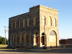 | Granville State Bank | building | 1977 | 77001509 |
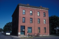 | Hotel Berry | building | 1982 | 82001343 |
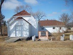 | Liberty Baptist Church | building | 1987 | 87001789 |
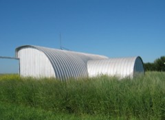 | Lower Souris National Wildlife Refuge Airplane Hangar | building | 2011 | 11000140 |
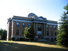 | McHenry County Courthouse | building | 1980 | 80002917 |
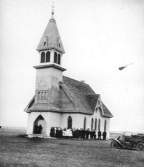 | Norway Lutheran Church and Cemetery | building | 1994 | 94001216 |
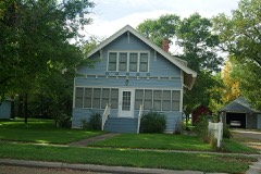 | Alfred and Clara Sevareid House | building | 1996 | 96001066 |
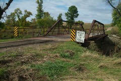 | Westgaard Bridge | structure | 1997 | 97000180 |
Every wildfire the federal occurrence database records inside this county: 135 of them, burning about 12,624 acres. 6 started naturally and none was recorded as arson. Each settlement page carries the fires within five miles of it.
| Reported cause | Fires |
|---|---|
| Missing data/not specified/undetermined | 39 |
| Debris and open burning | 36 |
| Equipment and vehicle use | 27 |
| Recreation and ceremony | 8 |
| Railroad operations and maintenance | 7 |
| Natural | 6 |
| Smoking | 5 |
| Power generation/transmission/distribution | 3 |
| Other causes | 3 |
| Fireworks | 1 |
The five largest, by the area the report gives. None of them was recorded as arson.
| Date | Cause | Size | Reported by | Name on the report |
|---|---|---|---|---|
| 4 April 2000 | Equipment and vehicle use | 4,000 acres | J. Clark Salyer National Wildlife Refuge | RED CROSS |
| 18 April 2008 | Missing data/not specified/undetermined | 1,701 acres | J. Clark Salyer National Wildlife Refuge | POOL 326 |
| 2 May 1994 | Debris and open burning | 1,640 acres | J. Clark Salyer National Wildlife Refuge | ASPEN |
| 24 March 2016 | Debris and open burning | 1,240 acres | North Dakota State Forest Service | ROBERTS |
| 28 February 2016 | Equipment and vehicle use | 640 acres | North Dakota State Forest Service | JERRY SEVLAND |
| 4 March 2016 | Debris and open burning | 640 acres | North Dakota State Forest Service | MINNESOTA DAVE |
| 28 October 2003 | Missing data/not specified/undetermined | 244 acres | J. Clark Salyer National Wildlife Refuge | NATIVES |
| 26 January 2005 | Recreation and ceremony | 200 acres | North Dakota State Forest Service | not named |
Every settlement page carries the fires within five miles of it - see the settlement index below.
The NOAA Storm Events Database holds 354 reports for this county, causing no deaths, no injuries and about $9,071,500 in recorded property damage. Each settlement page carries the reports that name it.
| Kind of event | Reports |
|---|---|
| Hail | 197 |
| Thunderstorm Wind | 84 |
| Tornado | 42 |
| Funnel Cloud | 10 |
| Flood | 9 |
| Flash Flood | 7 |
| Heavy Rain | 4 |
| Lightning | 1 |
The most serious of them, by death, then injury, then recorded damage. The accounts are quoted exactly as the forecast office filed them.
| When | Event | Place named | Harm | What the report says |
|---|---|---|---|---|
| May 2011 | Flood | Deering | $5,000,000 | See the event episode narrative for details. |
| July 2020 | Thunderstorm Wind | Anamoose | $850,000 | A fertilizer and chemical storage building to the west of Anamoose was destroyed. A one-half mile stretch of power lines were down onto Highway 52. Many trees were severely damaged or toppled within the city of Anamoose, with vehicles and some structures damaged. |
| June 2025 | Thunderstorm Wind | Voltaire | $350,000 | Extensive damage occurred to the grain elevator at Voltaire. Two large grain bins were blown completely over with other bins damaged. In addition, the grain leg connecting all the bins from the main terminal was blown off. |
| July 2022 | Thunderstorm Wind | Norfolk | $300,000 | Several barn structures in the area were significantly damaged, with some possibly being a total loss. |
| June 2016 | Thunderstorm Wind | Deering | $250,000 | Widespread damage occurred in Deering, with shingles torn off many roofs and some brick chimneys damaged. Multiple trees blew down and a ten-thousand bushel anchored grain bin blew over. |
| June 2015 | Thunderstorm Wind | Towner | $250,000 | Strong wind gusts were accompanied by hail the size of golf balls. There was damage to structures and automobiles. |
| April 2009 | Flood | Deering | $152,000 | Flooding along both the Willow Creek and the Souris River, in addition to overland flooding, resulted in washed out roads and damage to eight homes. |
| July 2025 | Thunderstorm Wind | Voltaire | $150,000 | Large grain bins were damaged with one being knocked over. This was in an area which had damaging wind gusts earlier in the summer. |
| July 2024 | Hail | Norfolk | $150,000 | Ping pong ball size hail combined with 80 mph wind gusts to cause extensive crop and home damage in the area. The house at this location lost some windows, along with suffering extensive damage to the roof and siding. Vehicles were also damaged. |
| July 2011 | Hail | Velva | $150,000 | The large hail caused damage to area crops. The hail also damaged windows, siding, and vehicles. The damage amount is estimated. |
| April 2023 | Flood | Upham | $140,000 | Flooding from snow melt runoff caused significant damages to county infrastructure. |
| July 2021 | Thunderstorm Wind | Karlsruhe | $100,000 | Thunderstorm wind gusts to 75 mph combined with hail to the size of golf balls to cause significant damage. Window screens were shredded on a home and a camper, windows were broken and siding damaged. A nearby potato field was shredded, and a corn field was about 50 percent damaged. Cottonwood trees were blown over, and cut hay was blown away. |
| June 2007 | Tornado (EF1) | Upham | $100,000 | The tornado damage path was 1/2 mile from the intersection of 7th Avenue North and 74th Street North, 6 mile south of Upham, toward the southeast. The damage width was 250 yards. Damage was mainly to trees and outbuildings on one farm property, and corresponded to an EF1 rating on the Enhanced Fujita Scale. From this rating, wind speeds were determined to be on the order of 100 mph. Some specific damage included 3 to 4 foot diameter trees uprooted, roof torn off of chicken coop, and a large barn kinked on its foundation. |
| July 2010 | Flash Flood | Drake | $75,000 | Officials reported up to two feet of water covering streets in Drake. The Mayor of Drake reported street damage from the water in the northwest corner of the town. Water damage was also reported to homes due to water entering basements. |
| July 2025 | Thunderstorm Wind | Velva | $70,000 | A metal out-building was severely damaged by the wind. Pieces of the metal then blew into a multi family home causing damage to the roof. |
| June 2005 | Flash Flood | Granville | $70,000 | no account filed |
| July 2010 | Thunderstorm Wind | Balfour | $60,000 | The strong thunderstorm winds resulted in extensive tree damage and destroyed a pole barn. |
| March 2009 | Flood | Deering | $60,000 | Overland flooding damaged state, county and township roads. No homes were flooded in March. Flooding continued and worsened into April. |
| May 2013 | Flood | Velva | $50,000 | A late season rapid snow melt caused flooding along the Souris (Mouse) River through southwest McHenry County. Additionally, there were necessary releases from upstream dams in North Dakota and Saskatchewan, Canada, due to rapid snow melt there. Some roads near the river were damaged. |
| July 1994 | Tornado (F1) | Velva | $50,000 | The tornado was reported by many observers and by the public. Its path was limited to the rural areas of the county. There were no injuries and the damage was mostly to crops and trees. |
| May 1994 | Tornado (F0) | Towner | $50,000 | Tornado did damage to grain bins and to the roofs of buildings. The path length and width of the tornado were estimated. |
| August 1994 | Thunderstorm Wind | Karlsruhe | $50,000 | no account filed |
| June 2013 | Flood | Velva | $45,000 | This river flooding was in part a continuation from the spring flooding that began in April and continued through May and into June. Some river points remained above flood stage through this period. The heavy rains through May and into June kept high water flowing through the system. |
| June 2010 | Thunderstorm Wind | Voltaire | $40,000 | The strong thunderstorm winds overturned a semi-trailer. |
| May 1998 | Thunderstorm Wind | Upham | $40,000 | New machine shop destroyed, equipment in shop OK. |
| July 2010 | Tornado (EF0) | Balfour | $30,000 | A brief tornado touchdown occurred at a farmstead near Balfour. The tornado destroyed an outbuilding and did no other damage. The damage was consistent with EF0 tornado damage from the Enhanced Fujita Scale. From that it was determined that the wind speeds were around 80 mph. |
| August 1994 | Tornado (F0) | Granville | $30,000 | no account filed |
| August 1994 | Thunderstorm Wind | Balfour | $30,000 | no account filed |
| July 2022 | Thunderstorm Wind | Velva | $25,000 | Significant tree damage occurred in Velva, with one large tree uprooted. |
| June 2012 | Thunderstorm Wind | Deering | $25,000 | The strong winds blew over a sailboat causing damage to a home. |
| July 1997 | Thunderstorm Wind | Anamoose | $25,000 | 20 foot tree crashed through a house |
| June 1997 | Tornado (F0) | Deering | $25,000 | The tornado touched down just ouside of the town. It moved northeast and hit the edge of a farm. A small barn was destroyed by the tornado as it moved through. Damage amout estimated |
| June 1982 | Tornado (F2) | not stated | $25,000 | no account filed |
| August 1979 | Tornado (F1) | not stated | $25,000 | no account filed |
| May 1977 | Tornado (F1) | not stated | $25,000 | no account filed |
| September 2024 | Hail | Bergen | $20,000 | Vehicles were dented by the golf ball size hail. |
| April 2013 | Flood | Velva | $20,000 | A late season rapid snow melt caused flooding along the Souris (Mouse) River through southwest McHenry County. Additionally, there were necessary releases from upstream dams in North Dakota and Saskatchewan, Canada, due to rapid snow melt there. Some roads near the river were damaged. |
| June 2007 | Thunderstorm Wind | Velva | $20,000 | Trees snapped and a few uprooted. |
| August 2006 | Flash Flood | Towner | $20,000 | Water as much as 8 inches deep in the streets of the downtown area flowed over the curbs and sidewalks and into businesses. Motorists had to find alternate routes around the city. Most of the damage was of the cleaning up variety typically associated with minor flood waters. |
| July 2025 | Thunderstorm Wind | Balfour | $15,000 | The roof of a metal shop was damaged. |
| July 2017 | Thunderstorm Wind | Karlsruhe | $15,000 | Large tree branches were broken down throughout the city of Karlsruhe. |
| June 2010 | Thunderstorm Wind | Berwick | $15,000 | Severe thunderstorm wind gusts resulted in multiple large trees to become uprooted. |
| July 2010 | Thunderstorm Wind | Balfour | $15,000 | The strong thunderstorm winds blew down several trees. |
| June 2005 | Flash Flood | Karlsruhe | $13,000 | no account filed |
| June 1996 | Lightning | Balfour | $10,000 | no account filed |
| August 1994 | Hail | Karlsruhe | $10,000 | no account filed |
| June 2023 | Thunderstorm Wind | Towner | $5,000 | Numerous trees were damage. Cottonwoods 12 to 18 inches in diameter were snapped, and poplar tree branches of six to ten inches were also snapped. |
| June 2011 | Flash Flood | Bantry | $5,000 | Excessive runoff from heavy rain resulted in flash flooding over north central McHenry County. Low water crossing areas were flooded to a depth of between one and two feet. Damage to roads was minor. |
| July 2010 | Thunderstorm Wind | Towner | $5,000 | The intense thunderstorm winds were measured with a private weather station. The winds resulted in an old garage blown down. |
| May 1994 | Hail | Sawyer | $5,000 | Tornado did damage to grain bins and to the roofs of buildings. The path length and width of the tornado were estimated. |
| June 2023 | Thunderstorm Wind | Anamoose | $3,000 | Multiple tree branches were downed. |
| June 2007 | Hail | Upham | $3,000 | Reported by Atmospheric Resource Board Observer. A few broken windows. |
| July 1998 | Hail | Bantry | $3,000 | no account filed |
| May 1978 | Tornado | not stated | $2,500 | no account filed |
| September 2025 | Tornado (EFU) | Butte | - | This is the second event entry for one tornado that passed through two counties, McLean and McHenry. The tornado touched down in an open field south of Butte and impacted no structures before it ended just north of the county line north of Butte. There was no damage to evaluate. By National Weather Service policy the tornado is rated EF-U (Unknown). |
| September 2025 | Tornado (EFU) | Balfour | - | The tornado touched down in an open field west of Balfour and impacted no structures before it lifted northeast of Bergen. There was no damage to evaluate. By National Weather Service policy the tornado is rated EF-U (Unknown). |
| September 2025 | Tornado (EFU) | Karlsruhe | - | The tornado touched down in an open field west of Karlsruhe and impacted no structures. There was no damage to evaluate. By National Weather Service policy the tornado is rated EF-U (Unknown). |
| September 2025 | Tornado (EFU) | Karlsruhe | - | The tornado touched down in an open field northwest of Karlsruhe and impacted no structures before it dissipated east of Simcoe. There was no damage to evaluate. By National Weather Service policy the tornado is rated EF-U (Unknown). |
| September 2025 | Tornado (EFU) | Granville | - | The tornado touched down in an open field south of Granville and impacted no structures. There was no damage to evaluate. By National Weather Service policy the tornado is rated EF-U (Unknown). |
| July 2024 | Thunderstorm Wind | Simcoe | - | Thunderstorm wind gusts were estimated by a trained spotter. |
The Survey's mineral resources record lists 1 working inside this county. It is closed or unrecorded. Each settlement page carries the workings within five miles of it.
| Commodity | Workings |
|---|---|
| Sand and Gravel, Construction | 1 |
The least common of them first, because a county's hundredth gravel pit says nothing its first ten did not.
| Where | Site | Commodity | Status | Recorded |
|---|---|---|---|---|
| Velva Sand & Gravel | Sand and Gravel, Construction | Past Producer |
Named settlements recorded in the Geographic Names Information System, each with the topographic sheets covering it. Villages, hamlets and abandoned places alike. Each is shown with the nearest named watercourse or landform and the survey quadrangle it falls on.
Northeast McHenry unorganized territory · 58384 · Willow City SW quadrangle
6 sheets, 1950 to 1980