 Block
From the record
12 National Register listings published here.
Sources: the National Register database, National Park Service
52 topographic sheets cover 28 settlements here, and 12 properties are on the National Register of Historic Places.
12 National Register listings published here.
Sources: the National Register database, National Park Service
Every property in this county listed on the National Register of Historic Places, with the year it was listed and the federal nomination document.
| Photograph | Property | Type | Listed | Reference |
|---|---|---|---|---|
| Crystal Bridge | structure | 1997 | 97000507 | |
| Dease-Martineau House, Trading Post, and Oxcart Trail Segments | district | 2017 | 100001744 | |
| Drayton United Methodist Church | building | 1979 | 79001773 | |
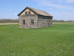 | Gingras House and Trading Post | building | 1975 | 75001305 |
| Grace Episcopal Church | building | 1994 | 94001075 | |
| Gunlogson Farmstead Historic Site | building | 2008 | 08000232 | |
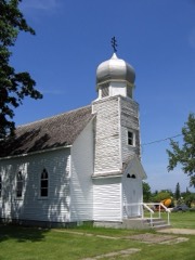 | Icelandic Evangelical Lutheran Church | building | 2019 | 100004714 |
| O'Connor House | building | 1980 | 80004544 | |
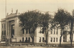 | Pembina County Courthouse | building | 1980 | 80002923 |
| US Customs House and Post Office-Pembina | building | 1989 | 89001755 | |
 | Vikur Lutheran Church at Mountain | building | 2013 | 13000862 |
 | Walla Theater | building | 2010 | 10000266 |
Every wildfire the federal occurrence database records inside this county: 43 of them, burning about 3,528 acres. 2 started naturally and none was recorded as arson. Each settlement page carries the fires within five miles of it.
| Reported cause | Fires |
|---|---|
| Debris and open burning | 23 |
| Missing data/not specified/undetermined | 9 |
| Equipment and vehicle use | 3 |
| Natural | 2 |
| Railroad operations and maintenance | 2 |
| Fireworks | 2 |
| Smoking | 1 |
| Misuse of fire by a minor | 1 |
The five largest, by the area the report gives. None of them was recorded as arson.
| Date | Cause | Size | Reported by | Name on the report |
|---|---|---|---|---|
| 21 October 1999 | Debris and open burning | 1,320 acres | Devil's Lake Wetland Management District | HOUGH&JUHL |
| 20 May 2002 | Missing data/not specified/undetermined | 700 acres | North Dakota State Forest Service | PEMBINA GORGE |
| 15 April 2015 | Equipment and vehicle use | 471 acres | Devil's Lake Wetland Management District | HOUGHTON JUHL WF |
| 21 May 2002 | Debris and open burning | 370 acres | Devil's Lake Wetland Management District | WALHALLA |
| 17 April 2000 | Missing data/not specified/undetermined | 300 acres | North Dakota State Forest Service | TONGUE RIVER |
| 2 May 2018 | Missing data/not specified/undetermined | 120 acres | North Dakota State Forest Service | LYLE SHEPARD FIRE |
| 18 July 2018 | Railroad operations and maintenance | 50 acres | North Dakota State Forest Service | RAILROAD FIRE |
| 13 May 2018 | Debris and open burning | 30 acres | North Dakota State Forest Service | GAPP FARM GRASS FIRE |
Every settlement page carries the fires within five miles of it - see the settlement index below.
The NOAA Storm Events Database holds 469 reports for this county, causing no deaths, 10 injuries and about $7,547,300 in recorded property damage. Each settlement page carries the reports that name it.
| Kind of event | Reports |
|---|---|
| Hail | 235 |
| Thunderstorm Wind | 133 |
| Tornado | 43 |
| Flood | 29 |
| Flash Flood | 13 |
| Funnel Cloud | 13 |
| Lightning | 2 |
| Heavy Rain | 1 |
The most serious of them, by death, then injury, then recorded damage. The accounts are quoted exactly as the forecast office filed them.
| When | Event | Place named | Harm | What the report says |
|---|---|---|---|---|
| June 1992 | Tornado (F1) | not stated | 4 hurt, $250,000 | no account filed |
| August 1997 | Lightning | Cavalier | 2 hurt, $20,000 | A man and his son were walking next to a tree when lightning struck. The two were knocked to the ground, with the tree taking the brunt of the strike. Two businesses in Cavalier were also hit by lightning, damaging their computer systems. |
| July 1992 | Hail | not stated | 2 hurt | no account filed |
| June 2005 | Thunderstorm Wind | Walhalla | 1 hurt, $2,000,000 | Widespread tree damage was reported in Walhalla. One tree fell on a tent in Walhalla, injuring one man. The other person in the tent was able to go for help. Widespread power outages occurred throughout the county. The Walhalla school building roof was heavily damaged. Flooding occurred in the school basement, due to the numerous holes in the roof. Emergency routes were blocked by fallen trees. Trees fell on cars, homes, garages, fences, and power lines. |
| July 2017 | Lightning | Drayton | 1 hurt | A woman was struck by lightning at the Drayton ND golf course. Reports indicate that the golfer received a ground pulse from a distant lightning strike which traveled up her golf club. |
| June 1999 | Tornado (F4) | Crystal | $1,000,000 | A tornado touched down southeast of Mountain, where it damaged several farmsteads. One farm home was completely lifted up and tossed 100 yards. A combine was also picked up and thrown several hundred feet. A swather was picked up and wrapped around several trees. In the town of Mountain, numerous trees were knocked flat. 2 mobile homes were destroyed, the roof was torn off a house, and a garage was destroyed. |
| June 2017 | Thunderstorm Wind | Mountain | $500,000 | Numerous large tree branches and limbs were broken down or snapped across much of Thingvalla Township. Sheet metal roofing and shingles were blown off buildings in various locations. |
| May 2010 | Flash Flood | Leroy | $500,000 | Three to seven inches of rain fell over portions of northeast Pembina County, causing street flooding, basement flooding, and sewer backup. Many fields were flooded outside of town. |
| July 2000 | Thunderstorm Wind | Joliette | $500,000 | Strong winds destroyed eight grain bins, knocked down some trees, and damaged the doors on a scale house. One of the 50 foot tall bins was carried away nearly 1000 feet, landing in a nearby farm field. The 8 bins were empty at the time, each capable of holding 50,000 bushels. Three large grain augers were also ruined. |
| September 2019 | Flash Flood | Cavalier | $250,000 | Streets, low spots, rivers, and basements were flooded by 4 to 9 inches of rain over a short duration of time. Cars that got stuck in the flood waters were abandoned where they stalled. Farm fields and access roads were also flooded. |
| April 2006 | Flood | Countywide | $237,000 | The Red River at Drayton rose above flood stage around 6 PM CST on April 3rd and remained above flood stage until around 1 PM CST on May 2nd. The river peaked at roughly 42.90 feet around 11 PM CST on April 10th. Unofficially, 42.90 feet would be the third highest modern-day river stage recorded. The Red River at Pembina rose above flood stage around 5 AM CST on April 5th and remained above flood stage until around 2 AM CST on May 3rd. The river peaked at roughly 51.45 feet around 8 PM CST on April 14th, unofficially the third highest modern-day river stage recorded. The Red River spread well out of it banks (8 miles wide in spots) from around Oslo (MN) northward, essentially becoming a lake. Overland flooding also occurred in addition to the river flooding, with many roads around the county closed due to flooding. U.S. Highway 81 had water on it between Glasston and Hamilton. Southern Manitoba's Highway 75 was shut down north of the Pembina border crossing, which resulted in detours for traffic. The Red River bridges at Drayton, Joliette, and Pembina were also closed during the flood. The city of Drayton had to build a temporary dike on Main Street, which closed a portion of State Highway 44. The Drayton Airport was also engulfed in water. In the city of Pembina, some temporary dike work and sandbagging also needed to be done. Problems also occurred along the Pembina River in the northern part of the county. In Walhalla, the city park was flooded. In Leroy, water came into town and several homes had to be sandbagged. A lot of flooding occurred around Neche, which was completely surrounded by water and inaccessible by road for a while. North of Neche, water covered State Highway 18 and the Canadians built a dike at the border crossing. Overland flooding also overtopped State Highway 18 south of Neche. The Neche bar was flooded in about 4 feet of water. Flooding continued to be quite extensive along the Canadian border from Neche to Pembina. The Governor authorized the National Guard to assist in the flood fight, providing assistance to Drayton and Pembina. The Guard troops were especially important to the flood fight in Neche, providing trucks and other equipment to haul sand and sandbags through roads covered in water. The Coast Guard also kept their airboats and helicopters in the area, providing assistance and support to stranded residents. Pembina County received a Presidential Disaster Declaration for damages caused by spring flooding. In summary, the total public and private flood losses experienced within the Red River of the North basin through late March and April 2006 were likely in excess of $20 million. This includes the following amounts. For Minnesota state and local infrastructure (this total includes the damages listed for each county), $8.5 million. For North Dakota state and local infrastructure (this total includes the damages listed for each county), $8 million. For Federal agencies (USACE, USGS, and USCG), $1.5 million. For the transportation industry costs due to traffic diversions caused by prolonged road and bridge closures, $1.5 million. For personal property losses due to floodwaters surrounding more than 500 individual farmsteads and rural homesteads, $1.0 million. |
| June 2017 | Tornado (EF1) | Mountain | $200,000 | This tornado snapped trees in shelterbelts and demolished a pole shed at a farmstead. In addition, shingles and roofing materials were peeled from various buildings and a television antenna was bent over. Debris was spread downstream and over a wide arc to the north and northwest by the east-southeast moving storm. Peak winds were estimated at 110 mph. |
| April 2023 | Flood | Drayton | $174,000 | Drayton - Crest of 40.38 ft occurred on 5/17 (Noted in May 2023 storm data). Flooding extended into May.||NOTE: Damages dollar amount is for the entire county. Not separated by specific river basin or damage type. |
| April 2023 | Flood | Pembina | $174,000 | Pembina - Crest of 46.68 ft occurred on 5/4 (Noted in May 2023 storm data). Flooding extended into May.||NOTE: Damages dollar amount is for the entire county. Not separated by specific river basin or damage type. |
| April 2023 | Flood | Neche | $174,000 | Neche gage, on the Pembina River. Crested at 19.22ft on April 16th at 04:15.||NOTE: Damages dollar amount is for the entire county. Not separated by specific river basin or damage type. |
| April 2023 | Flood | Neche | $174,000 | Neche gage, on the Pembina River. Second crest of 21.05 ft on April 18th at 20:15.||NOTE: Damages dollar amount is for the entire county. Not separated by specific river basin or damage type. |
| April 2023 | Flood | Walhalla | $174,000 | Walhalla gage, on the Pembina River. Crested at 13.16 ft on April 28th at 02:30.||NOTE: Damages dollar amount is for the entire county. Not separated by specific river basin or damage type. |
| April 2023 | Flood | Neche | $174,000 | Neche gage, on the Pembina River. Third Crest at 20.33 ft on April 29th at 05:00.||NOTE: Damages dollar amount is for the entire county. Not separated by specific river basin or damage type. |
| May 2013 | Flood | Crystal | $100,000 | Western portions of Crystal prepared for evacuation as small stream flooding encroached on the community. |
| July 2011 | Tornado (EF0) | Pembina | $100,000 | This tornado tracked eastward for about two miles and appears to have lifted just before reaching the Red River. The tornado was likely wrapped in downburst winds and rain as it tracked across the north side of Pembina. Though wind and hail occurred over a broad area of Pembina and Pembina East townships, there was more extreme tree branch damage and evidence of a tornado track across the north side of town. Peak winds were estimated at 85 mph. |
| June 2010 | Flood | Leroy | $100,000 | no account filed |
| May 2010 | Flood | Leroy | $100,000 | no account filed |
| July 2008 | Hail | Bathgate | $80,000 | Hail up to tennis ball size was reported midway between Neche and Cavalier. Extensive crop damage occurred across northern Cavalier Township and southern Felson Township. |
| May 2010 | Flood | Leroy | $50,000 | Heavy overnight rains produced rapid rises on the Pembina River and excessive runoff which overwhelmed city storm sewer pumping stations. Approximately 75 percent of homes in the community received some form of basement flooding as a result of excessive overland flow and ponding of rainwater. |
| April 2019 | Flood | Pembina | $50,000 | no account filed |
| March 2017 | Flood | Walhalla Arpt | $50,000 | no account filed |
| April 2017 | Flood | Walhalla Arpt | $50,000 | no account filed |
| July 1994 | Thunderstorm Wind | Joliette | $50,000 | no account filed |
| May 1993 | Hail | Cavalier | $50,000 | no account filed |
| August 1994 | Thunderstorm Wind | Cavalier | $40,000 | no account filed |
| July 1985 | Tornado (F1) | not stated | $25,000 | no account filed |
| July 2001 | Hail | Pembina | $20,000 | The hail broke many windows. |
| July 2008 | Hail | Bowesmont | $20,000 | no account filed |
| July 2012 | Flash Flood | Backoo | $15,000 | Heavy rains in excess of four inches in two hours across much of Advance and Cavalier North townships produced significant runoff in local creeks that feed into the Tongue River. One small creek washed out a box culvert/bridge along 98th Street Northeast, between 138th and 139th Avenue Northeast. |
| June 2016 | Flash Flood | Drayton | $10,000 | Interstate 29 near Drayton was temporarily closed due to flooding. |
| July 2011 | Hail | Neche | $10,000 | Quarter to half dollar sized hail fell. Wind drive hail produced crop, roofing, and some vehicle damage across neche township. |
| June 2009 | Flash Flood | Concrete | $10,000 | A culvert was blown out due to excessive rainfall about one mile east of Mountain. More flash flooding was reported about 2 miles north of Concrete. |
| July 2008 | Hail | Backoo | $10,000 | Extensive crop damage occurred across northern Advance Township and southern St. Joseph Township. |
| July 2001 | Hail | Pembina | $10,000 | The hail knocked out a yard light and damaged several vehicles. |
| May 2009 | Flood | Walhalla Arpt | $10,000 | no account filed |
| June 1996 | Thunderstorm Wind | Walhalla | $10,000 | no account filed |
| June 2010 | Flash Flood | Pembina | $5,000 | Western Pembina Township received five to six inches of rain in a three hour period. Farm fields and access roads were flooded along highway 55. |
| August 2008 | Hail | St Thomas | $5,000 | There were also one to three inch diameter branches blown down. |
| July 2008 | Tornado (EF1) | Hamilton | $5,000 | A funnel cloud was viewed by observers. A damage survey found evidence of a brief touchdown with several trees snapped off in a shelterbelt. Peak winds were estimated at 95 mph. |
| August 2001 | Thunderstorm Wind | St Thomas | $5,000 | Strong winds knocked over a grain auger. |
| August 2000 | Thunderstorm Wind | Cavalier | $5,000 | A tree was blown onto a roof. |
| August 2000 | Thunderstorm Wind | Cavalier | $5,000 | Numerous trees were damaged around the town. |
| May 2013 | Flood | Walhalla Arpt | $5,000 | no account filed |
| April 2013 | Flood | Walhalla Arpt | $5,000 | no account filed |
| March 2009 | Flood | Walhalla Arpt | $5,000 | no account filed |
| April 2009 | Flood | Walhalla Arpt | $5,000 | no account filed |
| May 2009 | Flood | Walhalla Arpt | $5,000 | no account filed |
| July 2008 | Tornado (EF1) | Pittsburg | $4,000 | This tornado tracked for about 3 miles, from about 6 miles north-northwest of Drayton to about 4 miles north-northeast of Drayton, before crossing the Red River into Kittson County (MN) by 839 pm CDT. The tornado continued into Kittson County for about 1 more mile before lifting about 9 miles west-northwest of Donaldson by 841 pm CDT. The tornado broke down several large tree branches, bent a road sign, and produced minor crops swirls. Peak winds were estimated at 90 mph. |
| August 2001 | Thunderstorm Wind | Drayton | $3,000 | Trees were blown down in Drayton. |
| August 1984 | Tornado (F1) | not stated | $2,500 | no account filed |
| June 2002 | Thunderstorm Wind | Crystal | $2,000 | Large trees were blown down across highway 66. A rapid temperature rise was also noted. |
| August 2000 | Thunderstorm Wind | St Thomas | $2,000 | Trees were blown down west of St. Thomas. |
| July 2006 | Tornado (F0) | Mountain | $1,000 | A tornado touched down briefly in a farm yard and tracked southeastward into open pastureland where it dissipated. The tornadic winds snapped a poplar tree off near the base and blew lawn furnature around the large multi-dwelling yard. A heavy tarpaulin which covered a large haystack row was partly shredded by the winds. Peak winds were estimated at 65 mph. |
| August 2002 | Thunderstorm Wind | Drayton | $1,000 | Large trees were blown down at the cemetary. |
| July 2001 | Flash Flood | St Thomas | $1,000 | Street flooding was reported in St. Thomas. |
The Survey's mineral resources record lists 1 working inside this county. It still produces. Each settlement page carries the workings within five miles of it.
| Commodity | Workings |
|---|---|
| Sand and Gravel, Construction | 1 |
The least common of them first, because a county's hundredth gravel pit says nothing its first ten did not.
| Where | Site | Commodity | Status | Recorded |
|---|---|---|---|---|
| Joe Mayo & Sons Pit | Sand and Gravel, Construction | Producer |
Named settlements recorded in the Geographic Names Information System, each with the topographic sheets covering it. Villages, hamlets and abandoned places alike. Each is shown with the nearest named watercourse or landform and the survey quadrangle it falls on.
St. Thomas township · 58276 · Glasston quadrangle
10 sheets, 1939 to 1985
No longer a settlement
Pembina township · 58271 · Pembina quadrangle
14 sheets, 1939 to 1985
No longer a settlement
The vanished settlements of Pembina County: the places named above that are no longer on the map.