 Block
From the record
4 National Register listings published here.
Sources: the National Register database, National Park Service
44 topographic sheets cover 11 settlements here, and 4 properties are on the National Register of Historic Places.
4 National Register listings published here.
Sources: the National Register database, National Park Service
Every property in this county listed on the National Register of Historic Places, with the year it was listed and the federal nomination document.
| Photograph | Property | Type | Listed | Reference |
|---|---|---|---|---|
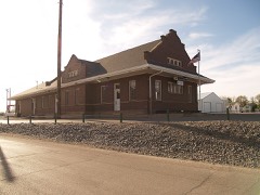 | Great Northern Passenger Depot | building | 1991 | 91001466 |
 | Pierce County Courthouse | building | 1980 | 80002924 |
| St. Paul's Episcopal Church | building | 1992 | 92001608 | |
 | US Post Office-Rugby | building | 1989 | 89001748 |
Every wildfire the federal occurrence database records inside this county: 183 of them, burning about 4,362 acres. 2 started naturally and 25 were recorded as arson. Each settlement page carries the fires within five miles of it.
| Reported cause | Fires |
|---|---|
| Missing data/not specified/undetermined | 101 |
| Debris and open burning | 44 |
| Arson/incendiarism | 25 |
| Fireworks | 3 |
| Power generation/transmission/distribution | 2 |
| Natural | 2 |
| Railroad operations and maintenance | 2 |
| Equipment and vehicle use | 2 |
| Smoking | 1 |
| Misuse of fire by a minor | 1 |
The five largest, by the area the report gives. None of them was recorded as arson.
| Date | Cause | Size | Reported by | Name on the report |
|---|---|---|---|---|
| 17 September 2007 | Debris and open burning | 785 acres | North Dakota State Fire Marshal's Office | not named |
| 8 April 2007 | Missing data/not specified/undetermined | 480 acres | North Dakota State Fire Marshal's Office | not named |
| 13 May 2002 | Debris and open burning | 300 acres | Turtle Mountain Agency | SECTION |
| 7 June 2019 | Railroad operations and maintenance | 250 acres | North Dakota State Forest Service | EAST OF TOWN ALONG TRACKS |
| 24 April 2019 | Debris and open burning | 200 acres | North Dakota State Forest Service | GROSSMAN FIRE |
| 6 May 2019 | Debris and open burning | 200 acres | North Dakota State Forest Service | 1 MILE WEST OF TUNBRIDGE |
| 13 November 2007 | Missing data/not specified/undetermined | 149 acres | North Dakota State Fire Marshal's Office | not named |
| 22 April 2018 | Debris and open burning | 100 acres | North Dakota State Forest Service | RON WENTZ |
Every settlement page carries the fires within five miles of it - see the settlement index below.
The NOAA Storm Events Database holds 185 reports for this county, causing no deaths, no injuries and about $4,730,030 in recorded property damage. Each settlement page carries the reports that name it.
| Kind of event | Reports |
|---|---|
| Hail | 93 |
| Thunderstorm Wind | 65 |
| Tornado | 15 |
| Funnel Cloud | 6 |
| Flood | 3 |
| Flash Flood | 2 |
| Lightning | 1 |
The most serious of them, by death, then injury, then recorded damage. The accounts are quoted exactly as the forecast office filed them.
| When | Event | Place named | Harm | What the report says |
|---|---|---|---|---|
| June 2005 | Thunderstorm Wind | Silva | $1,750,000 | Six (6) miles of 230 KV high voltage transmission lines down. |
| August 2016 | Hail | Rugby | $450,000 | Large hail occurred in the city of Rugby, with the largest hail falling near the intersection of US Highway 2 and ND Highway 3 on the south end of town. Damage occurred to structures and automobiles, and south of town to crops. |
| June 2023 | Thunderstorm Wind | Balta | $350,000 | Five empty anchored down hopper style grain bins were blown over, a trailer rolled through the yard, a gazebo was destroyed, a pool fence was blown down, and tall cottonwood trees were snapped. The farm had an anemometer on site that recorded the strongest wind gust. About one-quarter mile to the west, other trees were uprooted. |
| July 2011 | Tornado (EF1) | Rugby | $325,000 | A brief tornado touched down five miles south of Rugby on the leading edge of a linear severe thunderstorm. This tornado was within a larger area of straight line thunderstorm winds which also caused damage. Several buildings sustained damage or were destroyed by this tornado, along with trees, and three power poles were snapped along North Dakota Highway 3 where the tornado crossed. A semi truck was picked up along Highway 3 and thrown into the ditch. There were no injuries or deaths reported with this tornado. The tornado damage corresponded to EF1 on the Enhanced Fujita Scale. From that it was determined that wind speeds with this tornado were on the order of 100 miles per hour. |
| April 2009 | Flood | Barton | $271,000 | Heavy runoff generated from snowmelt caused overland flooding which washed out several county roads. |
| June 2005 | Tornado (F1) | Silva | $250,000 | Tornado touched down 8 miles south of Silva near Long Lake. It moved east-northeast and crossed into Benson County, Grand Forks NWS County Warning Area. Damage to high voltage transmission lines partly due to the tornado and partly due to 110 mph estimated wind gusts listed as a seperate entry. |
| July 1973 | Tornado (F1) | not stated | $250,000 | no account filed |
| August 1973 | Tornado (F2) | not stated | $250,000 | no account filed |
| June 2011 | Thunderstorm Wind | Barton | $150,000 | Winds were estimated at 100 miles per hour by a local resident with a wind meter. Numerous trees in the Barton area were uprooted, and several structures were damaged from the very strong winds. |
| July 2022 | Thunderstorm Wind | Barton | $125,000 | Multiple blue spruce trees were snapped and down to the east of Barton. In addition, some large cottonwoods and other native trees were uprooted and blown over. A free standing grain bin was also knocked over. |
| June 2017 | Thunderstorm Wind | Rugby | $75,000 | Very strong straight line winds occurred with a thunderstorm that moved from west of Rugby into Rugby. The strongest wind gust reported was an instantaneous, non-averaged measurement of 104 mph taken three miles west of Rugby by a research team from the National Severe Storms Laboratory, which would correlate to an estimated 87 mph 5-second average gust based upon past published research. Four miles west-northwest of Rugby a large, older barn collapsed. In Rugby, large evergreen trees were uprooted at the cemetery at the northwest end of town. |
| July 2011 | Thunderstorm Wind | Rugby | $75,000 | Several reports of high wind and damage were received from the Rugby area. Trees were uprooted, including a 60 foot tall spruce, numerous branches were broken, and a large shop was damaged around five miles south of Rugby. There was a tornado within the high wind area. See the tornado entry for Pierce County. |
| July 2006 | Thunderstorm Wind | Balta | $75,000 | Much damage to a recreational area with picnic shelters and tables ripped apart. Roof torn off of a barn, many trees blown over, and grain bins blown over. Roof damage to other buildings in town and damage to two single stall garages. |
| August 2007 | Thunderstorm Wind | Balta | $45,000 | High wind blew down four 40 foot trees. Nickel to walnut sized hail was also reported with the winds. Buildings were damaged on a farmstead northwest of Balta, along with major crop damage across central Pierce county due to the combined affects of the wind and hail. |
| September 2024 | Flash Flood | Orrin | $35,000 | Torrential rain occurred over the area with 4.5 inches falling that evening, which combined with an additional 1.5 inches that fell during the day. A road used for a driveway was washed out by the runoff, while ditches and culverts overflowed and damaged gravel roads. |
| July 2011 | Thunderstorm Wind | Rugby | $35,000 | Tree branches were blown down throughout the city of Rugby. |
| July 2011 | Thunderstorm Wind | Balta | $30,000 | The strong thunderstorm winds blew down box elder trees and bent a flagpole. |
| July 2020 | Thunderstorm Wind | Rugby | $25,000 | Multiple power poles were snapped. |
| August 2019 | Thunderstorm Wind | Barton | $25,000 | The winds combined with one-inch diameter hail to damage siding on a home. Crops were also damaged. |
| March 2009 | Flood | Barton | $25,000 | Overland flooding damaged county and township roads. No homes were flooded in March. Flooding continued into April. |
| June 1989 | Tornado (F1) | not stated | $25,000 | no account filed |
| June 2023 | Thunderstorm Wind | Rugby | $15,000 | Multiple large tree branches were broken off, with a few broken trees. |
| August 2009 | Thunderstorm Wind | Selz | $15,000 | Severe thunderstorm winds blew down trees near Selz. |
| August 2005 | Thunderstorm Wind | Rugby | $15,000 | 60 mph wind at 735 PM CDT increased to 71 mph at 739 PM CDT and maxed out at 95 mph at 742 PM CDT. Rugby also had one inch of rain from the storm and pea sized hail that covered the ground. Numerous tree branches down in the city. |
| July 1997 | Lightning | Rugby | $12,000 | lightning struck 5 N of Rugby. 19 head of cattle took shelter from the storm under a tree. The tree got struck by lightning, killing all cattle huddled under the tree |
| June 2019 | Thunderstorm Wind | Wolford | $10,000 | A tree of unknown diameter was split in half mid-way up the trunk. Multiple small and large branches were also broken. |
| August 1994 | Hail | Rugby | $5,000 | no account filed |
| June 2023 | Thunderstorm Wind | Orrin | $4,000 | Evergreen trees near the home were sheared off at roof level. |
| May 1998 | Hail | Rugby | $4,000 | Damage to car windows and house siding. |
| June 2023 | Thunderstorm Wind | Balta | $3,000 | no account filed |
| May 1978 | Tornado (F1) | not stated | $2,500 | no account filed |
| June 1977 | Tornado (F0) | not stated | $2,500 | no account filed |
| May 1998 | Hail | Rugby | $1,000 | no account filed |
| July 1978 | Tornado (F1) | not stated | $30 | no account filed |
| July 2022 | Thunderstorm Wind | Selz | - | The severe wind gusts combined with dime size hail to cause soybean field damage. |
| July 2020 | Thunderstorm Wind | Barton | - | Wind gusts to 60 mph were estimated by a trained spotter. |
| July 2020 | Thunderstorm Wind | Barton | - | Wind gusts to 60 mph were estimated by a trained spotter. |
| July 2017 | Funnel Cloud | Rugby | - | A brief funnel cloud was reported. |
| August 2014 | Thunderstorm Wind | Wolford | - | A trained spotter estimated the wind speed and noted crop damage. |
| July 2013 | Hail | Balta | - | The hail resulted in crop damage. |
| June 2012 | Funnel Cloud | Wolford | - | A brief funnel cloud was reported west of Wolford. |
| June 2012 | Funnel Cloud | Wolford | - | The funnel cloud previously reported west of Wolford was again spotted just outside the city limits. |
| June 2011 | Thunderstorm Wind | Barton | - | Winds were estimated at 60 miles per hour. |
| May 2010 | Thunderstorm Wind | Balta | - | Very heavy rain accompanied the severe thunderstorm winds. |
| July 2010 | Funnel Cloud | Wolford | - | A brief funnel cloud formed. |
| July 2009 | Hail | Silva | - | No damage was reported. |
| June 2008 | Thunderstorm Wind | Rugby | - | Strong thunderstorm winds were reported from KZZJ radio in Rugby. |
| June 2008 | Hail | Rugby | - | Trained spotters reported 20 minutes of quarter size hail from ten miles northwest to seven miles northwest of Rugby. |
| June 2008 | Hail | Rugby | - | Nickel to ping pong ball size hail was reported in the city of Rugby, and lasted for around 20 minutes. No report of damage was received from this event. |
| May 2007 | Thunderstorm Wind | Rugby | - | Storm total rain was 1.57 inches. |
| August 2007 | Hail | Rugby | - | Hail up to nickel size lasted 20 minutes. |
| July 2007 | Thunderstorm Wind | Rugby | - | A report from the public in Rugby also included peak winds of around 70 mph during this time. |
| July 2006 | Thunderstorm Wind | Rugby | - | Trees up to 3 feet in diameter snapped in half. |
| June 2005 | Flash Flood | Orrin | - | Water several feet deep in some fields. Water from culverts flowing over county roads. |
| July 2005 | Tornado (F0) | Selz | - | Tornado briefly touched down in open country. No damage reported. |
| July 2005 | Thunderstorm Wind | Rugby | - | Street signs and trees knocked over in Rugby. Roofs were damaged and some torn from buildings. Also had 1.75 inches of rain from the storm. |
| May 2004 | Tornado (F1) | Barton | - | The tornado destroyed a barn. |
| August 2004 | Thunderstorm Wind | Rugby | - | A few trees blown down from the strong winds. |
| June 2001 | Thunderstorm Wind | Rugby | - | Numerous small tree's reported down and fence knocked over at a golf course. |
| June 2001 | Tornado (F0) | Orrin | - | Tornado briefly touched down in open country. |
The Survey's mineral resources record lists 4 workings inside this county. All of them still produce. Each settlement page carries the workings within five miles of it.
| Commodity | Workings |
|---|---|
| Sand and Gravel, Construction | 4 |
The least common of them first, because a county's hundredth gravel pit says nothing its first ten did not.
| Where | Site | Commodity | Status | Recorded |
|---|---|---|---|---|
| Galen Construction Pit | Sand and Gravel, Construction | Producer | ||
| Orville Miller Pit | Sand and Gravel, Construction | Producer | ||
| Pierce County Pit | Sand and Gravel, Construction | Producer | ||
| Walter Otto Const Pit | Sand and Gravel, Construction | Producer |
Named settlements recorded in the Geographic Names Information System, each with the topographic sheets covering it. Villages, hamlets and abandoned places alike. Each is shown with the nearest named watercourse or landform and the survey quadrangle it falls on.