 Block
From the record
8 National Register listings published here.
Sources: the National Register database, National Park Service
33 topographic sheets cover 13 settlements here, and 8 properties are on the National Register of Historic Places.
8 National Register listings published here.
Sources: the National Register database, National Park Service
Every property in this county listed on the National Register of Historic Places, with the year it was listed and the federal nomination document.
| Photograph | Property | Type | Listed | Reference |
|---|---|---|---|---|
 | Bradford Hotel | building | 1987 | 87001766 |
| Colton's Crossing Bridge | structure | 1997 | 97000186 | |
 | Lisbon Bridge | structure | 1997 | 97000184 |
 | Lisbon Opera House | building | 1979 | 79003727 |
| Mizpah Lodge Building | building | 2005 | 05000913 | |
 | Ransom County Courthouse | building | 1985 | 85002988 |
 | US Post Office-Lisbon | building | 1989 | 89001749 |
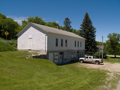 | T. J. Walker Historic District | district | 1979 | 79001774 |
Every wildfire the federal occurrence database records inside this county: 87 of them, burning about 7,137 acres. 2 started naturally and 1 was recorded as arson. Each settlement page carries the fires within five miles of it.
| Reported cause | Fires |
|---|---|
| Debris and open burning | 45 |
| Missing data/not specified/undetermined | 13 |
| Equipment and vehicle use | 12 |
| Railroad operations and maintenance | 7 |
| Recreation and ceremony | 4 |
| Power generation/transmission/distribution | 3 |
| Natural | 2 |
| Arson/incendiarism | 1 |
The five largest, by the area the report gives. One of them was set deliberately.
| Date | Cause | Size | Reported by | Name on the report |
|---|---|---|---|---|
| 7 May 2013 | Debris and open burning | 1,382 acres | Dakota Prairie National Grasslands | GREGOR |
| 24 March 2003 | Debris and open burning | 943 acres | Dakota Prairie National Grasslands | OLERUD |
| 24 August 2016 | Equipment and vehicle use | 700 acres | North Dakota State Forest Service | BARRY KYLSTAD TRACTOR/BALER FIRE |
| 7 May 2018 | Debris and open burning | 640 acres | North Dakota State Forest Service | HUETHER FIRE |
| 20 November 2017 | Arson/incendiarism | 500 acres | North Dakota State Forest Service | GAYLEN DICK |
| 22 October 2011 | Recreation and ceremony | 498 acres | Dakota Prairie National Grasslands | NORTHWEST D |
| 15 March 2015 | Debris and open burning | 400 acres | North Dakota State Forest Service | HOCK FIRE |
| 18 December 2020 | Debris and open burning | 282 acres | North Dakota State Forest Service | BROWN RANCH |
Every settlement page carries the fires within five miles of it - see the settlement index below.
The NOAA Storm Events Database holds 365 reports for this county, causing 1 death, 8 injuries and about $7,383,150 in recorded property damage. Each settlement page carries the reports that name it.
| Kind of event | Reports |
|---|---|
| Hail | 170 |
| Thunderstorm Wind | 116 |
| Tornado | 34 |
| Flash Flood | 18 |
| Flood | 13 |
| Funnel Cloud | 10 |
| Lightning | 2 |
| Heavy Rain | 2 |
The most serious of them, by death, then injury, then recorded damage. The accounts are quoted exactly as the forecast office filed them.
| When | Event | Place named | Harm | What the report says |
|---|---|---|---|---|
| June 2013 | Flash Flood | Lisbon | 1 killed, $5,000 | A pickup was swept off North Dakota Highway 32 into Dead Colt Creek. The vehicle floated downstream and was eventually submerged resulting in one fatality by 8 am CDT. |
| August 1970 | Tornado (F2) | not stated | 7 hurt, $25,000 | no account filed |
| June 1969 | Tornado (F1) | not stated | 1 hurt, $25,000 | no account filed |
| July 2010 | Tornado (EF2) | Lisbon Muni Arpt | $2,000,000 | This tornado was embedded in a squall line which also produced large hail and a wide swath of damaging downburst winds. The most extreme tornado damage was observed at two farmsteads, one about four miles west of Lisbon where a barn was ripped off its foundation and destroyed, and another about 4 miles ESE of Lisbon where a well constructed steel shop was completely blown apart. At least three wooden power poles were snapped at two different locations east of Lisbon. Numerous lareg trees were blown down or uprooted in Lisbon, and many homes and business had extensive roofing damage. peak winds estimated to 120 mph. |
| August 1999 | Tornado (F2) | Ft Ransom | $1,200,000 | Most of the damage from the tornado occurred roughly 3 miles northeast of Fort Ransom, just across the Sheyenne River. One farm had a wood barn and 2 large pole barns completely destroyed. At another nearby farm, another wood barn and a pole barn were destroyed, some debris deposited several hundred feet away. Numerous large trees were broken and a feeding car was thrown a half a mile away. Thousands of large trees surrounding the path of the tornado were snapped in two, many of these along the Sheyenne River Valley. |
| July 2010 | Tornado (EF1) | Elliott | $1,000,000 | This tornado was embedded in a squall line which also produced large hail and a wide swath of damaging downburst winds. the most extreme tornado damage was observed at two farmsteads northwest of elliot and in the town of elliot where wooden quonset structures and large steel grain bins were violently crumpled and tossed in various directions. Peak winds estimated to 105 mph. |
| July 2007 | Tornado (EF2) | Sheldon | $1,000,000 | The tornado cut a large gap in mature hardwood trees near the Sheyenne River and snapped several wooden power poles. Several sections of a large irrigation system were also tipped over. Peak winds were estimated at 115 mph. Some crops were damaged in Owego Township. |
| July 2007 | Thunderstorm Wind | Mc Leod | $500,000 | The wind gust was reported by a storm chaser with portable wind equipment. Large trees fell on homes and grain bin parts were scattered in town. |
| July 2007 | Tornado (EF1) | Sheldon | $250,000 | This tornado began in Cass County at 625 pm CST. The tornado yanked one aluminum high voltage power tower out of its steel footings and toppled several others. It also snapped several wooden power poles at multiple road crossings across its path. Peak winds were estimated at 105 mph. |
| July 1998 | Tornado (F1) | Lisbon | $250,000 | A tornado touched down on a farmstead, destroying numerous buildings. One barn was destroyed and 60 hogs inside were killed. Power was knocked out. The tornado crossed highway 27 and dissipated. |
| July 2007 | Thunderstorm Wind | Anselm | $200,000 | The wind gust was measured by a storm chaser with portable wind equipment. Large hail and damaging winds produced extensive crop damage across Coburn Township. |
| July 2007 | Thunderstorm Wind | Mc Leod | $200,000 | Trees were blown down and a grain bin was blown over. One tree fell on a motorhome. Downburst winds and hail produced crop damage across portions of Sandoun Township. |
| April 2006 | Flood | Countywide | $113,000 | Water tables remained high across Ransom County after substantial rainfall in 2005. Roughly 48 road and bridge sites were closed, especially in the southeast portion of the county. Ransom County received a Presidential Disaster Declaration for damages caused by spring flooding. |
| July 2007 | Thunderstorm Wind | Sheldon | $100,000 | Trees were blown down at the Sheldon cemetery, damaging some gravestones. Additional crop damage occurred in Greene Township. |
| July 2007 | Hail | Mc Leod | $100,000 | Golfball sized hail broke windows and was still left on the ground the next morning. |
| April 2023 | Flood | Enderlin | $64,000 | Enderlin Gage ENDN8 on the Maple River. Crested at 12.69 feet on April 18th at 15:30.||NOTE: Damages dollar amount is for the entire county. Not separated by specific river basin or damage type. |
| April 2019 | Flood | Ft Ransom | $50,000 | no account filed |
| July 2010 | Thunderstorm Wind | Lisbon Muni Arpt | $40,000 | And old barn collapsed and the back end of a pole shed was blown off by damaging downburst winds. |
| June 2002 | Thunderstorm Wind | Sheldon | $30,000 | A pole barn was blown down. |
| June 1987 | Tornado (F0) | not stated | $25,000 | no account filed |
| April 1982 | Tornado (F2) | not stated | $25,000 | no account filed |
| July 1980 | Tornado (F1) | not stated | $25,000 | no account filed |
| September 1970 | Tornado (F1) | not stated | $25,000 | no account filed |
| August 1965 | Tornado (F0) | not stated | $25,000 | no account filed |
| August 1957 | Tornado (F2) | not stated | $25,000 | no account filed |
| June 2001 | Lightning | Lisbon | $15,000 | Lightning struck a home in Lisbon, starting a fire in the attic. |
| August 2010 | Flash Flood | Ft Ransom | $10,000 | The heavy rain washed out a road north of Fort Ransom, stranding its driver. |
| June 1998 | Thunderstorm Wind | Lisbon | $10,000 | Numerous trees were uprooted, power lines were downed, the roof blew off the armory, and the roof blew off the Ransom county highway department shop. A building at the fairgrounds was also damaged. Lisbon was without power from 5 to 9 pm. |
| August 2016 | Flash Flood | Elliott | $5,000 | Farm and field access roads were flooded by persistent heavy rainfall. Ditches and culverts ran full. An observer measured 6.80 inches of rain over a 36 hour period. |
| June 2013 | Flash Flood | Elliott | $5,000 | North Dakota Highway 32 was closed between Gwinner and Lisbon at Dead Colt Creek. |
| August 2008 | Hail | Ft Ransom | $5,000 | Several sections of cropland in Northland Township received damage from hail and wind. |
| July 1999 | Thunderstorm Wind | Mc Leod | $5,000 | Large trees were uprooted. One tree fell on a trailer home. |
| March 2009 | Flood | Ft Ransom | $5,000 | no account filed |
| April 2009 | Flood | Ft Ransom | $5,000 | no account filed |
| May 2009 | Flood | Ft Ransom | $5,000 | no account filed |
| October 2004 | Lightning | Lisbon | $2,000 | Lightning struck the side of a house in Lisbon. The strike blew the telephone box off the side of the house and knocked a hole in the house foundation. |
| August 2001 | Thunderstorm Wind | Lisbon | $2,000 | Trees were blown down. |
| June 1998 | Thunderstorm Wind | Englevale | $2,000 | Strong winds blew 55 gallon drums around a damaged house. |
| July 2001 | Thunderstorm Wind | Mc Leod | $1,000 | Tree branches were blown down. |
| July 2001 | Thunderstorm Wind | Mc Leod | $1,000 | Tree branches were blown down. |
| March 2010 | Flash Flood | Lisbon | $500 | The Sheyenne River rose rapidly through central portions of Lisbon, in response to an ice jam which formed near the highway 27 bridge. Flood water rose above the moderate flood stage by 11 pm CDT and eventually crested above the major flood stage. Emergency levees had been constructed in advance and emergency crews were able to contain the flooding. |
| August 2001 | Thunderstorm Wind | Anselm | $500 | Branches were blown down. |
| March 2009 | Flash Flood | Lisbon | $500 | no account filed |
| June 1999 | Thunderstorm Wind | Anselm | $500 | no account filed |
| August 1997 | Thunderstorm Wind | Mc Leod | $500 | no account filed |
| July 1966 | Tornado | not stated | $250 | no account filed |
| June 1998 | Thunderstorm Wind | Englevale | $200 | Several 10 inch tree limbs were broken in the strong wind. |
| June 1998 | Thunderstorm Wind | Elliott | $200 | Trees were downed in the strong wind. |
| August 2025 | Thunderstorm Wind | Enderlin | - | Tree damage reported across Enderlin. Also a report of a damaged play shed. Time estimated from radar. |
| June 2025 | Tornado (EF2) | Ft Ransom | - | First visible indication of the tornado occurred at 1017pm. The tornado tracked NE for about 3.3 miles from its start doing mainly tree and power line damage. It did do some EF1 roof damage to one farmstead in this initial phase. The tornado tracked across 117th Ave and damaged 3 power poles. Lifted north tracking over open fields which showed some ground scouring via satellite imagery. Then the tornado struck a farmstead from the southeast and spread the debris to the north/Northwest. The tornado continued to the northwest crossing 117th and taking out a another power pole as it roped out. This tornado's path was about 5.2 miles long and 400 yards wide. |
| June 2025 | Tornado (EFU) | Ft Ransom | - | This was likely caused by a satellite tornado associated with the EF-2 tornado to the west. High resolution satellite imagery reveals tornado scarring on open field. No evidence of damage seen on satellite imagery nor reports received that could correlated with current EF scale damage indicators. |
| June 2025 | Tornado (EF0) | Anselm | - | This tornado developed in Cass County before crossing Highway 46 into Ransom County, then weakened and dissipated. This tornado was on the ground for around 7 miles, at its widest was about 1351 in Cass county. In Ransom County its widest was 519 yards as it crossed into the county. Damage indicators along the path of this tornado correlates to EF-2 damage in Cass, with peak winds estimated to be around 120 mph in that county. Along the path of this tornado was extensive tree damage, including trees snapped and uprooted. Ground scouring and crop damage was visible from high resolution satellite data correlating with at least EF-0 damage at 85 mph. This ground scouring extended into Ransom county about 0.65 miles. |
| June 2025 | Tornado (EF0) | Sheldon | - | Tornado scar evident via high resolution satellite through farm fields. |
| June 2025 | Tornado (EF5) | Enderlin Arpt | - | This large and violent tornado began with minor damage to a few branches about 3 miles SSW Enderlin but within 2.5 miles of the track, the tornado gained intensity and |significantly widened. While south of Highway 46, between 56th and 57th Street SE, the tornado derailed 33 train cars including 19 fully-loaded grain hopper cars and 14 empty tanker cars, mainly tipped from the track. Included in the derailed cars were one filled grain car (286,000 lbs) and four empty tanker cars (72,000 lbs) that were pulled into a field away from the track. One of the 4 tanker cars was tossed 600-1000 ft (183-305 m) from the track and an estimated 475.7 ft (145 m) from the distance of the previous tanker car it was attached to before being pulled off of the track; wheel sets detached near the point from which the cars were derailed from the track. It was in this train derailment location that EF-5 damage intensity was noted with greater than 210 mph winds listed officially for this tornado.||Extensive collaboration with wind damage experts provided forensic analyses for the train damage that occurred with this tornado. These analyses estimate potential wind speeds of approximately 230 mph are needed to completely overturn a fully loaded grain hopper car. Collaboration with the Northern Tornadoes Project at Western Universitys Canadian Severe Storms Laboratory estimated a potential wind speed of >119 m/s (>266 mph) to loft the empty tanker car 475.7 ft (145 m) using similar calculations performed in Estimating Wind Speeds in Tornadoes Using Debris Trajectories of Large Compact Objects (Miller et al. 2024). The study, published in the Monthly Weather Review, found that large compact objects lofted greater than 50 m indicate EF-5 intensity winds (greater than 200 mph). The Enderlin train cars were nearly 2 farther than the EF-5 threshold distance and 4 heavier than the heaviest object modeled in the study. The maximum wind speed also correlates to the timing of the maximum strength observed via the WSR-88D storm-relative velocity data from KMVX.||The tornado continued to widen as it tracked to the north and east. Just to the south of Highway 46, a free standing cell phone tower (FST DOD 2) collapsed, and it impacted several farmsteads with outbuildings destroyed. Extensive vegetation damage occurred with crops destroyed, bark stripped from trees with a sandpapering effect noted on numerous trees, and many large trees snapped or stubbed. Large tree root balls of 18-24 diameter trunks were displaced, and in some cases, it was unknown where the uprooted trees originated from. EF-4 damage was noted with the trees. The tornado continued to track northward crossing Highway 46 into southwestern Cass County. The tornado statistics for the Ransom County portion include: a length of 5.4 miles, a maximum width of 1850 yards, a maximum wind of greater than 210 mph (EF-5), and 0 fatalities. Total track length between Ransom and Cass counties was 12.1 miles. Monetary damage estimates were not available. |
| June 2024 | Thunderstorm Wind | Ft Ransom | - | Tree Damage in Fort Ransom State Park. |
| June 2024 | Thunderstorm Wind | Englevale | - | Public reported 67 MPH wind gust off their personal weather station and shingles blown off the roof. |
| June 2024 | Tornado (EFU) | Ft Ransom | - | A trained storm spotter (DouglasB27) reported a tornado moving southeast towards highway 32 and had been on the ground 5 minutes prior to call. |
| June 2022 | Thunderstorm Wind | Ft Ransom | - | A personal weather station measured a 60 mph wind gust near Fort Ransom. |
| June 2022 | Thunderstorm Wind | Ft Ransom | - | A personal weather station measured a 62 mph wind gust near Fort Ransom. |
| June 2022 | Thunderstorm Wind | Enderlin | - | Received a report of a large tree down in Enderlin. Received the report via social media. |
The Survey's mineral resources record lists 4 workings inside this county. 3 still produce and 1 is closed or unrecorded. Each settlement page carries the workings within five miles of it.
| Commodity | Workings |
|---|---|
| Sand and Gravel, Construction | 4 |
The least common of them first, because a county's hundredth gravel pit says nothing its first ten did not.
| Where | Site | Commodity | Status | Recorded |
|---|---|---|---|---|
| Evo Pit | Sand and Gravel, Construction | Producer | ||
| Lisbon Pit | Sand and Gravel, Construction | Past Producer | ||
| Lisbon Sand & Gravel Pit | Sand and Gravel, Construction | Producer | ||
| Olson Pit | Sand and Gravel, Construction | Producer |
Named settlements recorded in the Geographic Names Information System, each with the topographic sheets covering it. Villages, hamlets and abandoned places alike. Each is shown with the nearest named watercourse or landform and the survey quadrangle it falls on.
Alleghany township · 58054 · Elliott SE quadrangle
7 sheets, 1953 to 1989
No longer a settlement
Enderlin city · 58027 · On South Branch Maple River · Enderlin South quadrangle
10 sheets, 1897 to 1989
Fort Ransom township · 58033 · Near The Pyramid · Fort Ransom quadrangle
10 sheets, 1897 to 1989
Springer township · 58054 · Near Oestreicher Hill · Nome SE quadrangle
10 sheets, 1897 to 1989
No longer a settlement
The vanished settlements of Ransom County: the places named above that are no longer on the map.