 Block
From the record
2 National Register listings published here.
Sources: the National Register database, National Park Service
26 topographic sheets cover 9 settlements here, and 2 properties are on the National Register of Historic Places.
2 National Register listings published here.
Sources: the National Register database, National Park Service
Every property in this county listed on the National Register of Historic Places, with the year it was listed and the federal nomination document.
| Photograph | Property | Type | Listed | Reference |
|---|---|---|---|---|
| Mckinney Cemetery | site | 1978 | 78001994 | |
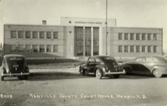 | Renville County Courthouse | building | 1985 | 85002989 |
Every wildfire the federal occurrence database records inside this county: 34 of them, burning about 959 acres. 2 started naturally and 1 was recorded as arson. Each settlement page carries the fires within five miles of it.
| Reported cause | Fires |
|---|---|
| Missing data/not specified/undetermined | 12 |
| Equipment and vehicle use | 8 |
| Debris and open burning | 5 |
| Smoking | 2 |
| Natural | 2 |
| Power generation/transmission/distribution | 2 |
| Railroad operations and maintenance | 1 |
| Recreation and ceremony | 1 |
| Arson/incendiarism | 1 |
The five largest, by the area the report gives. None of them was recorded as arson.
| Date | Cause | Size | Reported by | Name on the report |
|---|---|---|---|---|
| 24 May 2009 | Missing data/not specified/undetermined | 335 acres | Upper Souris National Wildlife Refuge | MOUSE RIVER PARK |
| 3 May 2013 | Equipment and vehicle use | 166 acres | Upper Souris National Wildlife Refuge | CHOO CHOO |
| 15 August 2015 | Natural | 106 acres | Upper Souris National Wildlife Refuge | LEAVITT |
| 5 May 2002 | Missing data/not specified/undetermined | 105 acres | Upper Souris National Wildlife Refuge | GREENE WF |
| 11 April 1992 | Debris and open burning | 100 acres | Upper Souris National Wildlife Refuge | EMERSON |
| 15 March 2002 | Missing data/not specified/undetermined | 40 acres | Upper Souris National Wildlife Refuge | MOUSE PARK |
| 18 March 2008 | Equipment and vehicle use | 36 acres | Upper Souris National Wildlife Refuge | MAU RANCH |
| 7 December 2020 | Missing data/not specified/undetermined | 12 acres | Upper Souris National Wildlife Refuge | MOUSE PARK |
Every settlement page carries the fires within five miles of it - see the settlement index below.
The NOAA Storm Events Database holds 175 reports for this county, causing 1 death, 4 injuries and about $9,784,000 in recorded property damage. Each settlement page carries the reports that name it.
| Kind of event | Reports |
|---|---|
| Hail | 91 |
| Thunderstorm Wind | 42 |
| Tornado | 25 |
| Flash Flood | 7 |
| Funnel Cloud | 6 |
| Flood | 4 |
The most serious of them, by death, then injury, then recorded damage. The accounts are quoted exactly as the forecast office filed them.
| When | Event | Place named | Harm | What the report says |
|---|---|---|---|---|
| July 1997 | Tornado (F2) | Greene | 1 killed, 2 hurt, $46,000 | A tornado touched down 12 miles south of Greene or 7 N of Carpio. The tornado touched down directly on a farmhouse. The house was blown off of the foundation, then blown apart. A 70 yr. old man was blown out of the house, while a 1 month old infant was trapped in the debris. A 73 yr old woman was also trapped under the debris. She was alive when found but passed away at the hospital from her injuries. |
| July 1989 | Tornado (F0) | not stated | 1 hurt, $250,000 | no account filed |
| August 1984 | Thunderstorm Wind | not stated | 1 hurt | no account filed |
| May 2011 | Flood | Tolley | $5,000,000 | See the event episode narrative for details. |
| June 2011 | Flash Flood | Sherwood | $1,000,000 | Runoff from very heavy rainfall resulted in a rapid four foot rise along the Souris River near Sherwood. A mandatory evacuation was ordered for Mouse River Park located in McKinney Township. One hundred homes, 150 camping sites, and several businesses and buildings were impacted as the Souris River overtopped levees and flash flooded these areas. Dollar damage here is not all inclusive from the flooding. |
| July 1997 | Thunderstorm Wind | Tolley | $700,000 | Strong winds toppled 85 thousand bushel grain bin. The bin had 4 thousand bushel in it at the time. Another grain bin with more grain in it was severely dented toward the top of the bin. |
| July 2004 | Thunderstorm Wind | Mohall | $500,000 | no account filed |
| July 2007 | Hail | Norma | $350,000 | Storm accompanied by 60 mph wind gusts. Extensive crop damage to thousands of acres of various crops. Thirteen different farms had crop damage. Some crops were completely destroyed. Damage also to siding and windows on farm buildings. Newspaper article read that the total damage could amount to several million dollars. |
| July 1989 | Tornado (F0) | not stated | $250,000 | no account filed |
| August 1988 | Tornado (F0) | not stated | $250,000 | no account filed |
| July 1977 | Tornado | not stated | $250,000 | no account filed |
| August 2024 | Thunderstorm Wind | Tolley | $200,000 | Seven hopper style bins were blown over. |
| August 2024 | Thunderstorm Wind | Norma | $150,000 | A roof was blown off of a pole barn, and the walls were also damaged. |
| August 2024 | Hail | Tolley | $100,000 | The hail combined with thunderstorm wind gusts to destroy a wheat field. |
| July 2007 | Hail | Mohall | $100,000 | There was crop and building damage on 7 farms in northeast Renville County. The storm put out large hail and wind gusts to 60 mph. |
| June 2014 | Flood | Tolley | $96,000 | Flooding occurred over Renville County. Damage occurred to roads and culverts with many wash outs along township roads. There was crop damage as well. Rain amounts ranged from 2.50 inches in Bottineau County to as much as 7.00 inches in Renville County. |
| July 2009 | Tornado (EF1) | Sherwood | $80,000 | This tornado touched down in rural parts of northern Renville County. There was damage done on a farmstead nine miles west and four miles south of Sherwood. The tornado damage was rated low end EF1 on the Enhanced Fujita Tornado Scale. From that it was determined that wind speeds were on the order of 90 mph. No injuries or deaths were reported. |
| May 2010 | Flash Flood | Tolley | $75,000 | Numerous roadways in northeastern Renville County near Sherwood were submerged due to heavy thunderstorm rains. Tree and other debris were also reported on roads. Several roads were reported washed out or closed. |
| August 2024 | Hail | Norma | $50,000 | The hail combined with thunderstorm wind gusts to damage the roof and siding on a home. |
| June 2005 | Flash Flood | Glenburn | $50,000 | Flash flood from Glenburn to 5 miles west Glenburn. Deep water 2 to 3 feet in fields. Water flowed into homes. Some roads under water. |
| July 1997 | Thunderstorm Wind | Glenburn | $50,000 | Numerous trees and outbuilding toppled. Also a grain bin was knocked over. |
| July 1994 | Hail | not stated | $50,000 | Large hail damaged buildings, cars, and crops. Crop damage was estimated at 50 to 100 percent in some areas. |
| June 2016 | Thunderstorm Wind | Tolley | $40,000 | Power lines were down along with tree limbs. One-third of the city of Tolley was without power following the storm. |
| May 2010 | Thunderstorm Wind | Sherwood | $40,000 | Severe thunderstorm winds resulted in snapped power lines. |
| July 2012 | Thunderstorm Wind | Tolley | $25,000 | The strong winds uprooted numerous large trees. |
| May 2010 | Flash Flood | Sherwood | $25,000 | Local law enforcement reported water over several roads in the city of Sherwood. Another report from a trained weather spotter also indicated flash flooding in Sherwood. Some lower maintenance roads were damaged. |
| August 1988 | Tornado (F0) | not stated | $25,000 | no account filed |
| June 2011 | Flash Flood | Mohall | $10,000 | Excessive runoff from heavy rain resulted in flash flooding near and south of Mohall with water running nearly two feet deep over roads. Gravel roads were in need of repair after the event. There was a report of one inch of rain in 20 minutes from storms moving through the area. |
| August 1994 | Tornado (F0) | Near Grano | $10,000 | ,The path was estimated. |
| June 2005 | Flash Flood | Glenburn | $5,000 | Roads under water and closed to traffic. |
| August 1996 | Thunderstorm Wind | Mohall | $5,000 | no account filed |
| June 2024 | Thunderstorm Wind | Mohall | $1,000 | Some tree branches were down. |
| July 2017 | Thunderstorm Wind | Tolley | $1,000 | A 12-inch diameter ash tree trunk split. |
| August 2024 | Hail | Norma | - | The hail combined with thunderstorm wind gusts to cause crop damage in the area. |
| July 2023 | Thunderstorm Wind | Grano | - | Wind combined with small hail to damage some crops. |
| July 2022 | Thunderstorm Wind | Grano | - | Thunderstorm wind gusts were estimated by a trained spotter. |
| September 2021 | Thunderstorm Wind | Glenburn | - | Thunderstorm wind gusts were estimated by the public. The winds combined with small hail to strip leaves off trees. |
| July 2016 | Tornado (EF0) | Loraine | - | A tornado touched down in a rural area west of Loraine and traveled about one-third mile. No damage, injuries, or fatalities were reported. Because the tornado impacted no structures it was rated EF-0. |
| July 2013 | Thunderstorm Wind | Mohall | - | Heavy rain accompanied the strong winds. |
| September 2013 | Thunderstorm Wind | Tolley | - | Pea size hail accompanied the strong winds. |
| July 2011 | Flood | Tolley | - | See the event episode narrative for details. |
| June 2011 | Flood | Tolley | - | See the event episode narrative for details. |
| May 2011 | Tornado (EF0) | Tolley | - | A tornado briefly touched down near Tolley in Renville County. The tornado touched down in open country and impacted no structures. No damage occurred with this brief EF0 tornado witnessed by a deputy sheriff. |
| July 2010 | Thunderstorm Wind | Norma | - | Estimated winds of 60 mph were reported. |
| July 2009 | Funnel Cloud | Sherwood | - | Law enforcement reported this brief funnel cloud near Sherwood. |
| August 2008 | Hail | Glenburn Arpt | - | Nickel to quarter size hail was reported. |
| June 2007 | Thunderstorm Wind | Sherwood | - | Small tree branches broken. |
| August 2007 | Hail | Mohall | - | There was no report of damage. |
| July 2005 | Tornado (F0) | Sherwood | - | Tornado briefly touched down in open country. No damage reported. |
| July 2004 | Thunderstorm Wind | Tolley | - | Quanset shop and grain bins demolished. |
| July 2003 | Thunderstorm Wind | Mohall | - | Power outage for several hours reported. Heavy rain accompanied the storm. |
| August 2002 | Hail | Glenburn | - | Most crops in the Glenburn area wiped out. Majority of the homes and other buildings in the Glenburn area sustain hail damage. |
| June 2001 | Tornado (F0) | Sherwood | - | The tornado moved slowly east reaching the Bottineau county line around 925 pm cst. The tornado skipped over the open country side. |
| June 2001 | Funnel Cloud | Glenburn | - | Two funnel clouds were observed briefly. |
| August 2000 | Tornado (F0) | Sherwood | - | Tornado crossed over into Renville county from burke county remaining in open county. Total path of storm was 6 miles before dissipating in Renville county. |
| August 2000 | Tornado (F0) | Mohall | - | Tornado touch down in open country and skipped across rural areas crossing into bottineau county. |
| August 2000 | Thunderstorm Wind | Glenburn | - | Emergency Management reported tree branches down. |
| June 1999 | Tornado (F0) | Loraine | - | in open field. no damage. |
| May 1998 | Tornado (F0) | Grano | - | Brief touch down reported by deputy. |
| May 1998 | Tornado (F0) | Glenburn | - | Brief touch down as seen from the Minot Air Force Base. |
The Survey's mineral resources record lists 4 workings inside this county. 2 still produce and 2 are closed or unrecorded. Each settlement page carries the workings within five miles of it.
| Commodity | Workings |
|---|---|
| Sand and Gravel, Construction | 4 |
The least common of them first, because a county's hundredth gravel pit says nothing its first ten did not.
| Where | Site | Commodity | Status | Recorded |
|---|---|---|---|---|
| Daeley Sand and Gravel | Sand and Gravel, Construction | Unknown | ||
| Elson Pit and Plant | Sand and Gravel, Construction | Producer | ||
| Siebert Pit | Sand and Gravel, Construction | Producer | ||
| William Clairmont Inc Sc | Sand and Gravel, Construction | Past Producer |
Named settlements recorded in the Geographic Names Information System, each with the topographic sheets covering it. Villages, hamlets and abandoned places alike. Each is shown with the nearest named watercourse or landform and the survey quadrangle it falls on.