 Block
From the record
6 National Register listings published here.
Sources: the National Register database, National Park Service
26 topographic sheets cover 14 settlements here, and 6 properties are on the National Register of Historic Places.
6 National Register listings published here.
Sources: the National Register database, National Park Service
Every property in this county listed on the National Register of Historic Places, with the year it was listed and the federal nomination document.
| Photograph | Property | Type | Listed | Reference |
|---|---|---|---|---|
 | Dickinson (Carnegie Area) Public Library | building | 2008 | 08000735 |
 | Dickinson State Normal School Campus District | district | 1997 | 97000285 |
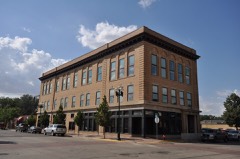 | Elks Club and Store Building-Dickenson Lodge #1137 | building | 2008 | 08000280 |
| Gerhardt Octagonal Pig House | building | 86002758 | ||
 | Stark County Courthouse | building | 1985 | 85002991 |
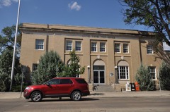 | US Post Office-Dickinson | building | 1989 | 89001757 |
Every wildfire the federal occurrence database records inside this county: 115 of them, burning about 4,086 acres. 14 started naturally and 1 was recorded as arson. Each settlement page carries the fires within five miles of it.
| Reported cause | Fires |
|---|---|
| Equipment and vehicle use | 38 |
| Missing data/not specified/undetermined | 25 |
| Debris and open burning | 14 |
| Natural | 14 |
| Railroad operations and maintenance | 12 |
| Smoking | 5 |
| Fireworks | 2 |
| Recreation and ceremony | 2 |
| Power generation/transmission/distribution | 2 |
| Arson/incendiarism | 1 |
The five largest, by the area the report gives. None of them was recorded as arson.
| Date | Cause | Size | Reported by | Name on the report |
|---|---|---|---|---|
| 1 September 2004 | Missing data/not specified/undetermined | 1,500 acres | North Dakota State Forest Service | RICHARDTON |
| 21 March 2012 | Railroad operations and maintenance | 800 acres | North Dakota State Forest Service | BNSF/ALVIN WANNER |
| 16 March 2008 | Missing data/not specified/undetermined | 640 acres | North Dakota State Forest Service | JOE K WANNER |
| 19 July 2015 | Equipment and vehicle use | 160 acres | North Dakota State Forest Service | BOB PRIVERATSKY |
| 10 August 2020 | Natural | 160 acres | North Dakota State Forest Service | 2020 0082 |
| 10 June 2017 | Natural | 100 acres | North Dakota State Forest Service | RICHARD |
| 8 September 2005 | Missing data/not specified/undetermined | 80 acres | North Dakota State Forest Service | not named |
| 18 August 2015 | Equipment and vehicle use | 80 acres | North Dakota State Forest Service | DAVE KUBAS |
Every settlement page carries the fires within five miles of it - see the settlement index below.
The NOAA Storm Events Database holds 493 reports for this county, causing 1 death, 2 injuries and about $31,338,000 in recorded property damage. Each settlement page carries the reports that name it.
| Kind of event | Reports |
|---|---|
| Hail | 221 |
| Thunderstorm Wind | 220 |
| Tornado | 26 |
| Funnel Cloud | 9 |
| Lightning | 8 |
| Flash Flood | 4 |
| Heavy Rain | 3 |
| Flood | 2 |
The most serious of them, by death, then injury, then recorded damage. The accounts are quoted exactly as the forecast office filed them.
| When | Event | Place named | Harm | What the report says |
|---|---|---|---|---|
| August 2019 | Lightning | Richardton | 1 killed | A 32-year old male died when he was struck by lighting while working on a trail at the Schnell Recreation Area east of Richardton in Stark County. At the time of the strike the victim was loading mowing equipment into the back of a pickup truck. |
| July 2009 | Tornado (EF3) | Dickinson | 2 hurt, $20,000,000 | Meteorologists from the National Weather Service conducted a storm damage survey in and around Dickinson on Thursday, July 9th, 2009. Meteorologists walked through the area and spoke with numerous people affected, many of whom were eye witnesses to the event.||This tornado passed through the city of Dickinson on the far south side, mainly just south of the Heart River. No witnesses spoken to actually saw the tornado. From their eye witness accounts, and from video obtained by the Dickinson Police Department, it is likely that this was a rain-wrapped tornado, and very difficult if not impossible to see. The tornado occurred before sunset, yet it was described as being as dark as night during the event.||The conclusion of the damage survey was that this tornado touched down around a mile or so outside the city limits, on the southwest side, and moved east-northeast, passing through the far southern part of the city. It lifted back into the parent thunderstorm on the extreme southeast side of Dickinson near the city limit. This occurred in the window between 815 PM MDT and 830 PM MDT.||Over 450 structures were damaged, of which nearly 100 were declared completely destroyed or beyond repair. Numerous vehicles were damaged or destroyed, some were on their roofs. Power lines were snapped, knocking out power to most of Dickinson, and tree damage was extensive. Two minor injuries were reported, with no deaths. The injuries were to a 23 year old male and a 42 year old male. Both occurred in homes.||The worst damage surveyed was between the Heart River and roughly 8th Street Southwest and 8th Street Southeast in southern Dickinson. Of that damage, the absolute worst corresponded to middle EF3 on the Enhanced Fujita Tornado Scale. From that it was determined that peak wind speeds in the tornado were on the order of 150 mph.||Other parts of Dickinson and the surrounding area sustained wind damage likely associated with the rear flank downdraft of the storm. |
| June 2005 | Thunderstorm Wind | Dickinson | $3,000,000 | Large hail accompanied the severe storm causing major damage to homes, businesses, vehicles and other buildings. Wind ASOS measured. |
| August 1999 | Hail | Dickinson | $2,000,000 | Damage occurred on the north side of Dickinson. |
| August 2013 | Thunderstorm Wind | Dickinson | $850,000 | A National Weather Service Storm Survey was done on the west side of Dickinson where wind damage occurred. The very high winds blew the roof off a storage unit and blew doors in. The debris from this building was blown to the southeast, and resulted in additional damage to several other buildings and vehicles. The damage surveyed was consistent with straight line winds and not a tornado. The damage surveyed indicated peak wind speeds of approximately 90 miles per hour. |
| June 2009 | Tornado (EF1) | Belfield | $700,000 | The same supercell thunderstorm that produced this EF1 tornado from 1628 MST to 1645 MST produced another tornado, an EF0, from 1703 MST to 1738 MST as it moved southeast. The first tornado, the EF1, was in Stark County, while the second, the EF0, started in Stark County and crossed into Hettinger County.||The Stark County tornado touched down about five miles south of Belfield and crossed U.S. Highway 85 as it moved southeast. It lifted nearly 12 miles south-southeast of Belfield after doing significant damage on a farm about 10 miles south-southeast of Belfield. There was no other damage reported outside of that one farm. Four structures were damaged or destroyed and several farm animals were killed. Only minor damage was done to the farm house. In addition to buildings, fences and vehicles were also damaged or destroyed. The damage corresponded to high end EF1 on the Enhanced Fujita Tornado Scale. From that it was determined that wind speeds were around 105 mph. There were no deaths or injuries. |
| August 2014 | Flood | South Heart | $550,000 | Upwards of six inches of rain in parts of Stark County led to overland flooding. There was damage to roads and crops in the northern part of the county. |
| June 2025 | Hail | (Dik)Dickinson Muni | $500,000 | Approximately 25 windows were broken on the north and east side of area homes, along with siding and roofing damage. Multiple vehicles were heavily damaged. |
| July 2022 | Flash Flood | Dickinson | $500,000 | Heavy rain moved through central Stark County, with over two inches of rain falling in a short period of time over the Dickinson area. Dickinson's storm water system was overwhelmed from the intense heavy rains and caused flooding to basements. Numerous streets were flooded and the underpass along Highway 22 was completely filled. Over 150 homes and businesses were affected by the flooding. |
| June 2025 | Tornado (EF1) | (Dik)Dickinson Muni | $300,000 | The tornado touched down approximately 9 miles southwest of Dickinson and traveled to the south approximately 1.4 miles. Two houses along the path of the tornado had roofs partially blown off and some siding ripped off. Tree damage also occurred, with one tree having an eight inch diameter branch snapped off. Fences were broken down and two power poles were broken. Based on the damage done this tornado was rated EF-1, and from that wind speeds were estimated to be around 100 mph. |
| August 1996 | Lightning | Dickinson | $300,000 | no account filed |
| August 2023 | Hail | Dickinson | $200,000 | Multiple vehicles were damaged. |
| July 2016 | Thunderstorm Wind | Dickinson | $200,000 | Numerous trees were snapped or uprooted on the south side of Dickinson. A camper was also flipped. |
| August 2010 | Hail | South Heart | $200,000 | The largest hailstone during this event was two and one half inches in diameter. The large hail damaged windows, siding, crops, and vehicles. |
| June 2006 | Thunderstorm Wind | Dickinson | $200,000 | Two barns and one pole barn destroyed. Broken windows in homes and mobile homes. Cattle injured. Storm accompanied by 0.88 inch diameter hail. Hail piled six inches deep against buildings. Farmer was quoted as saying the crops looked like they had been mowed by a lawn mower. |
| August 2016 | Hail | Taylor | $125,000 | Large hail punched holes in a steel building, and multiple windows were shattered. The roof of a house was damaged and a wheat field was destroyed. |
| September 2015 | Thunderstorm Wind | Belfield | $125,000 | Significant damage was done from extreme winds on the leading edge of the line of thunderstorms. Outbuildings were damaged, trees were snapped and some uprooted. The heaviest damage was about 6 miles northeast of Belfield. |
| June 2024 | Hail | Belfield | $100,000 | Hail combined with wind to dent tin on building roofs and shred window screens. In addition, crops were also damaged. |
| August 2016 | Hail | Richardton | $100,000 | Extensive property and crop damage were reported north of Richardton. No exact details were provided. |
| June 2023 | Thunderstorm Wind | Belfield | $80,000 | Thirty power poles were down along Highway 85. |
| June 2023 | Thunderstorm Wind | Gladstone | $60,000 | RV campers were overturned in Gladstone. |
| July 2025 | Thunderstorm Wind | Belfield | $50,000 | Metal roofing was partially torn off a building, with some other roofs damaged. |
| July 2025 | Hail | South Heart | $50,000 | Windows were broken by the hail, while roofs and vehicles were damaged. |
| July 2025 | Hail | Belfield | $50,000 | Vehicles were damaged by the hail. |
| June 2017 | Hail | Antelope | $50,000 | Multiple car windshields were broken between mile marker 90 and 91 on Interstate 94. |
| May 2007 | Thunderstorm Wind | Belfield | $50,000 | Machine shed on farm destroyed 5 miles south of Belfield. Barn 7 miles south of Belfield was damaged. |
| July 2007 | Flash Flood | Dickinson | $50,000 | Ditches and creeks were full to overflowing from 3 to 5 inches of rain in the area. Water was running nearly a foot deep over some county roads. |
| August 2006 | Hail | Gladstone | $50,000 | Damage to roofs, windows, and vehicles. |
| June 2009 | Hail | Belfield | $50,000 | no account filed |
| May 1994 | Thunderstorm Wind | Edgely | $50,000 | no account filed |
| April 1994 | Thunderstorm Wind | Taylor | $50,000 | no account filed |
| July 2009 | Thunderstorm Wind | Dickinson | $45,000 | Shingles were torn off of numerous structures due to these very strong thunderstorm winds. These winds were likely the result of the rear flank downdraft on the back side of a tornadic thunderstorm that was occurring around the same time in Dickinson. See the tornado entry for Stark County the same day from 1915 MST to 1930 MST. |
| June 2023 | Thunderstorm Wind | Richardton | $40,000 | Fifteen power poles were broken, all pushed towards the east. |
| August 2008 | Lightning | Dickinson | $40,000 | Lightning struck a house north of Dickinson, igniting a fire which damaged the roof and the attic. |
| June 2024 | Thunderstorm Wind | Dickinson | $30,000 | A tree fell onto a house. |
| June 2017 | Hail | Taylor | $30,000 | Wind driven hail caused damage to the home, barns, and vehicles. Multiple windows were shattered on the home causing damage inside. |
| July 2016 | Thunderstorm Wind | Taylor | $30,000 | Damage occurred at a farmstead where shingles blew off an out-building and window panes were blown out of a quonset. |
| August 2014 | Thunderstorm Wind | Lefor | $30,000 | A shed was destroyed and trees were damaged. |
| March 2009 | Flood | Belfield | $30,000 | The Green River and the Heart River flooded. Overland flooding also occurred and damaged county and township roads. Four homes were flooded. |
| June 2024 | Thunderstorm Wind | (Dik)Dickinson Muni | $25,000 | A trailer was flipped upside down, toward the east, and damaged. |
| June 2022 | Hail | Dickinson | $25,000 | Copious amounts of small hail fell over the Dickinson area. Although the hailstones were small, they piled up in drifts and blocked storm drains resulting in street flooding and stranding some cars. |
| June 2018 | Thunderstorm Wind | Dickinson | $25,000 | A tall tree blew over onto a truck. |
| June 2009 | Tornado (EF0) | (Dik)Dickinson Muni | $25,000 | This tornado touched down in Stark County and crossed into Hettinger County. See the tornado entry for Hettinger County 1707 MST to 1738 MST.||The same supercell thunderstorm that produced this EF0 tornado produced an EF1 tornado in Stark County earlier in the day. See the tornado entry 1628 MST to 1645 MST for Stark County.||The tornado touched down about three miles southwest of Schefield, Stark County. This touchdown location is about seven miles north-northwest of the Hettinger County city of New England. It moved southeast and crossed into Hettinger County and lifted about eight miles west-northwest of Regent, after doing damage to several farms. Several medium to large trees were uprooted and there was window and roof damage to buildings. The damage corresponded to high end EF0 on the Enhanced Fujita Tornado Scale. From that it was determined that wind speeds were around 85 mph. There were no deaths or injuries. |
| June 1997 | Thunderstorm Wind | Dickinson | $25,000 | The strong winds collapsed a pole barn as well as ripped the roofs off of a few out buildings. Damage amout estimated. |
| June 1997 | Hail | Dickinson | $25,000 | Numerous reports of car windshields being cracked or broken out. Also reports of damage to the siding of houses. Damage amounts estimated. |
| September 1996 | Lightning | 11 N Dickinson | $25,000 | no account filed |
| June 1976 | Tornado (F2) | not stated | $25,000 | no account filed |
| June 1952 | Tornado (F2) | not stated | $25,000 | no account filed |
| July 2025 | Thunderstorm Wind | Gladstone | $20,000 | An animal lean building was picked up and blown about 20 feet, destroying the building. |
| June 2021 | Thunderstorm Wind | Antelope | $20,000 | Three inch tree limbs were broken, and some power poles were broken. |
| June 2021 | Thunderstorm Wind | Richardton | $20,000 | A tree was down in town, along with a power line. |
| July 2003 | Thunderstorm Wind | (Dik)Dickinson Muni | $20,000 | Grain bin sustained major damage eight miles west of Dickinson. |
| June 1997 | Hail | Dickinson | $20,000 | A seperate second storm developed to the west of Dickinson and brought more hail to the town. More houses were damaged as well as more cars. Damage amounts estimated. |
| June 2017 | Hail | Richardton | $15,000 | Five windows were shattered by the hail. |
| June 2015 | Thunderstorm Wind | Dickinson | $15,000 | Tree limbs were downed as a result of the strong wind gusts. |
| June 2014 | Hail | South Heart | $15,000 | Most of the hail was quarter size, with a few as large as baseballs. There was damage to vehicles. |
| August 2011 | Flash Flood | South Heart | $15,000 | Four inches of rain in this area flash flooded parts of Highway 10 near South Heart forcing the closure of the road. Deep water was also reported just outside of Belfield. |
| July 2020 | Hail | Lefor | $10,000 | Hail combined with thunderstorm wind gusts to break some windows in the house and to break skylights on out-buildings. One coral wall was pushed over. |
| June 2011 | Tornado (EF0) | Richardton | $10,000 | The National Weather Service spoke to an eye witness who described this tornado. This tornado touched down briefly on the north side of Interstate 94 southwest of Richardton, lifting immediately after tearing part of a roof off of an outbuilding on a farm. This was the only damage attributed to this tornado, with no injuries or fatalities. Based on the damage description, this tornado was indicative of a strong EF0 tornado on the Enhanced Fujita Scale, with peak winds of 85 miles per hour. |
| April 1996 | Lightning | Belfield | $8,000 | no account filed |
The Survey's mineral resources record lists 5 workings inside this county. 2 still produce and 3 are closed or unrecorded. Each settlement page carries the workings within five miles of it.
| Commodity | Workings |
|---|---|
| Uranium | 3 |
| Sand and Gravel, Construction | 2 |
The least common of them first, because a county's hundredth gravel pit says nothing its first ten did not.
| Where | Site | Commodity | Status | Recorded |
|---|---|---|---|---|
| Badinger Pit & Plant | Sand and Gravel, Construction | Producer | ||
| Fisher Industries Plant #1 | Sand and Gravel, Construction | Producer | ||
| Frank | Uranium | Past Producer | ||
| Hecker No. 2 | Uranium | Past Producer | ||
| Luptak No. 1 | Uranium | Past Producer |
Named settlements recorded in the Geographic Names Information System, each with the topographic sheets covering it. Villages, hamlets and abandoned places alike. Each is shown with the nearest named watercourse or landform and the survey quadrangle it falls on.
Dickinson North unorganized territory · 58601 · On Ash Creek · South Heart quadrangle
5 sheets, 1953 to 1981
Dickinson South unorganized territory · 58601 · Schefield quadrangle
5 sheets, 1953 to 1981
South Heart city · 58655 · On South Branch Heart River · South Heart quadrangle
5 sheets, 1953 to 1981
West Stark unorganized territory · 58655 · On Norwegian Creek · Belfield NE quadrangle
6 sheets, 1953 to 1980