 Block
From the record
8 National Register listings published here.
Sources: the National Register database, National Park Service
42 topographic sheets cover 15 settlements here, and 8 properties are on the National Register of Historic Places.
8 National Register listings published here.
Sources: the National Register database, National Park Service
Every property in this county listed on the National Register of Historic Places, with the year it was listed and the federal nomination document.
| Photograph | Property | Type | Listed | Reference |
|---|---|---|---|---|
| Beiseker Mansion | building | 1977 | 77001036 | |
| Harvey High School | building | 2026 | 100012550 | |
| Harvey Power Plant | building | 2020 | 100005273 | |
| Hurd Round House | building | 1977 | 77001038 | |
| Manfred Historic District | district | 2017 | 100001813 | |
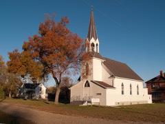 | Vang Evangelical Lutheran Church | building | 2001 | 01000674 |
 | Wells County Courthouse | building | 1977 | 77001037 |
| Wells County Fairgrounds | district | 1991 | 91000073 |
Every wildfire the federal occurrence database records inside this county: 22 of them, burning about 578 acres. 1 started naturally and 1 was recorded as arson. Each settlement page carries the fires within five miles of it.
| Reported cause | Fires |
|---|---|
| Debris and open burning | 14 |
| Missing data/not specified/undetermined | 4 |
| Equipment and vehicle use | 1 |
| Arson/incendiarism | 1 |
| Natural | 1 |
| Recreation and ceremony | 1 |
The five largest, by the area the report gives. One of them was set deliberately.
| Date | Cause | Size | Reported by | Name on the report |
|---|---|---|---|---|
| 12 May 1994 | Debris and open burning | 140 acres | Chase Lake Prairie Project Wetland Management District | SORENSON |
| 28 April 2016 | Arson/incendiarism | 133 acres | Chase Lake National Wildlife Refuge | HOORNAERT WPA |
| 5 May 2003 | Recreation and ceremony | 80 acres | Chase Lake Prairie Project Wetland Management District | BJERTNESS |
| 10 May 2019 | Debris and open burning | 80 acres | North Dakota State Forest Service | PRANKE FIRE |
| 6 June 2019 | Debris and open burning | 50 acres | North Dakota State Forest Service | 3431 28TH AVE NE SELZ |
| 18 November 2016 | Missing data/not specified/undetermined | 15 acres | North Dakota State Forest Service | HIGHWAY 3 |
| 29 July 2006 | Natural | 13 acres | Chase Lake Prairie Project Wetland Management District | VALHALLA |
| 9 December 1999 | Debris and open burning | 11 acres | Chase Lake Prairie Project Wetland Management District | SCHLINDLER |
Every settlement page carries the fires within five miles of it - see the settlement index below.
The NOAA Storm Events Database holds 232 reports for this county, causing no deaths, 1 injury and about $7,489,500 in recorded property damage. Each settlement page carries the reports that name it.
| Kind of event | Reports |
|---|---|
| Hail | 122 |
| Thunderstorm Wind | 60 |
| Tornado | 25 |
| Flash Flood | 11 |
| Funnel Cloud | 9 |
| Flood | 4 |
| Lightning | 1 |
The most serious of them, by death, then injury, then recorded damage. The accounts are quoted exactly as the forecast office filed them.
| When | Event | Place named | Harm | What the report says |
|---|---|---|---|---|
| June 1952 | Tornado (F3) | not stated | 1 hurt, $25,000 | no account filed |
| April 2009 | Flood | Harvey Arpt | $2,400,000 | Rapid snowmelt created heavy overland flooding and flooding in the upper James River basin. This resulted in flood damage to numerous county and township roads along with 201 homes. |
| June 2018 | Hail | Harvey | $850,000 | A slow moving supercell thunderstorm dropped very large hail on the Harvey area. House roofs and gutters were damaged throughout the city. Many vehicles were damaged with windshields and back windows shattered. Crops were damaged, though most were expected to rebound as the plants were young enough to do so. |
| June 2015 | Hail | Harvey | $750,000 | Hail was accompanied by wind gusts up to 60 mph. Damage was extensive to buildings and at an automobile dealership on the south side of Harvey. There was also crop damage. |
| June 2025 | Hail | Chaseley | $500,000 | Wind driven hail caused extensive damage throughout the community of Bowdon, with most homes suffering broken windows. Significant vehicle damage also occurred along with widespread roof damage. |
| September 2019 | Flash Flood | Hurdsfield | $500,000 | Deep flood waters flowed over many roads and caused damage throughout much of southern Wells County, where up to seven inches of rain fell from thunderstorms. Multiple roads were washed out and so closed for days. Parts of State Highway 200 and U.S. Highway 52 were closed resulting in major traffic detours. A part of State Highway 200 near Bowdon was washed out. The heavy rain also caused crop damage and yield loss. Hay bales were partially submerged in flood water. Soil erosion was extensive. |
| August 2021 | Hail | Fessenden | $300,000 | Multiple vehicles and roofs were damaged. |
| August 2021 | Hail | Bowdon | $250,000 | Vehicles were totaled and roofs damaged. |
| July 1953 | Tornado (F1) | not stated | $250,000 | no account filed |
| June 2020 | Flash Flood | Harvey Arpt | $200,000 | Multiple rounds of heavy rain fell over northwest and west-central Wells County, with a daily total of almost seven inches near the Harvey area. Many rural roads and fields were flooded. A side hill gave way onto a road on the west end of Harvey. |
| May 2010 | Thunderstorm Wind | Harvey | $200,000 | Very strong winds associated with a severe thunderstorm damaged a building at the Harvey airport and also blew over numerous trees and some power lines. Other structural damage was also sustained in and around the Harvey area. |
| June 2025 | Thunderstorm Wind | Sykeston | $150,000 | Multiple grain bins were damaged. Shingles and paneling were blown off another building. |
| June 2022 | Flash Flood | Sykeston | $150,000 | Heavy rain in excess of three inches fell on southeast Wells County during the late night hours. Johnson Township, south of Sykeston, suffered the greatest damage. Over this area, almost all roads had water over them, with many barricaded. Road washouts were numerous. |
| April 2023 | Flood | Harvey Arpt | $100,000 | Flooding from snow melt runoff caused significant damages to county infrastructure. |
| June 2018 | Thunderstorm Wind | Harvey | $80,000 | Three grain bins became dislodged and blew around the farm yard. One became wedged against the house. |
| June 2025 | Thunderstorm Wind | Fessenden | $75,000 | Numerous trees near the house and in a nearby shelter belt uprooted or snapped. Small shed demolished. Roof partially torn off of a small horse shed. |
| July 2018 | Thunderstorm Wind | Harvey | $60,000 | A well constructed wooden barn that was recently built was destroyed. Other farm buildings were damaged. A grain auger was toppled, and a large spruce tree was uprooted. |
| July 2011 | Flash Flood | Sykeston | $50,000 | Very heavy rain, estimated at near seven inches peak based on radar, fell over southeast Wells County. Roads in the area were flooded and damaged. |
| June 2010 | Thunderstorm Wind | Fessenden | $50,000 | Severe thunderstorm wind gusts resulted in extensive tree damage in and around the city of Fessenden. No structural damage was reported. |
| March 2009 | Flood | Harvey Arpt | $50,000 | Overland flooding damaged county and township roads. No homes were flooded in March. Flooding continued and worsened into April. |
| June 2018 | Hail | Harvey | $40,000 | There was damage to the gutters, siding, and roof of the home and other farm buildings. Crop damage was minimal as there was no wind with the hail. |
| August 2007 | Flash Flood | Fessenden | $40,000 | Rainfall of 6.5 inches in a 2 1/2 hour period caused flooding with water rushing over roads. |
| August 2009 | Thunderstorm Wind | Harvey | $35,000 | Severe thunderstorm winds resulted in a steel roof being blown off of a farm outbuilding and damage to fence posts. |
| September 2008 | Thunderstorm Wind | Sykeston | $30,000 | Damage occurred to outbuildings on the farm, including part of a metal roof being torn off and blown into the farm house. The metal roofing material and a two by four broke windows on the house. In one case a two by four ended up partially inside the residence. There were no injuries. |
| August 2009 | Thunderstorm Wind | Harvey Arpt | $25,000 | Severe thunderstorm winds blew the roof off of a barn. |
| August 2008 | Flash Flood | Harvey | $25,000 | Up to five inches of rain caused street flooding and blocked underpasses in the city of Harvey. In low spots in the city water was flowing through yards and into basements. The water had receded by around 1 AM CDT. |
| May 2006 | Flash Flood | Sykeston | $25,000 | 3.95 inches of rain. County roads under 8 inches of water. Culvert washed out. |
| August 1985 | Tornado (F0) | not stated | $25,000 | no account filed |
| July 1970 | Tornado (F1) | not stated | $25,000 | no account filed |
| August 1957 | Tornado (F1) | not stated | $25,000 | no account filed |
| July 1954 | Tornado (F2) | not stated | $25,000 | no account filed |
| June 2022 | Flash Flood | Hamberg | $20,000 | Heavy rain fell in the Hamberg area, with reports of around five inches. Water went over County Road 5, which is a primary paved road in Wells County. The edges of the road were washed out. |
| June 2022 | Thunderstorm Wind | Harvey Arpt | $20,000 | An apple tree was snapped in Harvey, and at the Harvey Golf Course, seven evergreen trees were uprooted. |
| June 2018 | Thunderstorm Wind | Harvey | $20,000 | A grain bin was dislodged and blown into the surrounding bins. Canola crop was pushed down by the strong winds. |
| May 2010 | Thunderstorm Wind | Chaseley | $20,000 | Strong winds associated with a severe thunderstorm caused some damage to a home. |
| May 2010 | Thunderstorm Wind | Hurdsfield | $20,000 | Strong winds associated with a severe thunderstorm blew over a semi trailer near Hurdsfield. |
| August 2009 | Thunderstorm Wind | Harvey | $20,000 | Numerous tree branches were reported blown down by severe thunderstorm winds in Harvey. |
| September 2014 | Thunderstorm Wind | Harvey | $10,000 | Numerous trees and branches were reported down. The winds were accompanied by pea sized hail. |
| August 2007 | Flash Flood | Sykeston | $10,000 | There was standing water around all of the farm buildings. |
| July 2020 | Thunderstorm Wind | Chaseley | $5,000 | Large tree branches were down. |
| August 2011 | Flash Flood | Bowdon | $5,000 | Thunderstorms produced around two inches of rain in this area leading to flash flooding along low water crossings. Damage was minimal and confined to eroded road shoulders. One report was that most of the rain fell in a 20 minute period. |
| August 2009 | Thunderstorm Wind | Heimdal | $5,000 | A fifteen inch in diameter box elder tree was blown down by severe thunderstorm winds. |
| June 2007 | Hail | Harvey | $5,000 | Damage to corn and soybeans on a farm 5 miles north-northeast of Harvey. |
| June 2013 | Flash Flood | Chaseley | $4,000 | Several county roads were reported to be under water. Rain reports ranged from an inch and a half to nearly three inches. |
| July 2020 | Thunderstorm Wind | Harvey | $3,000 | Large tree branches were down. |
| June 1978 | Tornado (F0) | not stated | $2,500 | no account filed |
| June 1966 | Tornado (F1) | not stated | $2,500 | no account filed |
| May 1965 | Tornado (F2) | not stated | $2,500 | no account filed |
| July 2017 | Thunderstorm Wind | Chaseley | $2,000 | Several large branches were blown down in Chaseley. |
| August 2011 | Thunderstorm Wind | Harvey | $2,000 | Small tree limbs were broken. |
| September 2023 | Thunderstorm Wind | Chaseley | $1,000 | A large evergreen tree blew over. |
| July 2025 | Thunderstorm Wind | Chaseley | - | The Bowdon area suffered notable tree damage, with one spruce tree uprooted, and some box elder trees snapped. The winds combined with hail up to one-inch in diameter to cause additional damage to homes and vehicles which were already significantly damaged from storms that passed through earlier in the summer. |
| July 2024 | Tornado (EFU) | Chaseley | - | The tornado touched down in an open field southeast of Chaseley and impacted no structures. There was no damage to evaluate. By National Weather Service policy the tornado is rated EF-U (Unknown). |
| July 2022 | Thunderstorm Wind | Hamberg | - | Small hail combined with the severe thunderstorm winds to cause extensive crop damage. |
| June 2022 | Tornado (EFU) | Chaseley | - | The tornado touched down in an open field north of Chaseley and impacted no structures. There was no damage to evaluate. By National Weather Service policy the tornado is rated EF Unknown. |
| June 2019 | Tornado (EF0) | Cathay | - | The tornado touched down in a field near Cathay. The tornado was given a rating of EF-0. |
| July 2019 | Thunderstorm Wind | Heaton | - | A trained spotter estimated thunderstorm wind gusts of 60 mph. |
| September 2019 | Thunderstorm Wind | Chaseley | - | A trained spotter reported thunderstorm wind gusts of 60 mph. |
| May 2018 | Thunderstorm Wind | Chaseley | - | A tree near the residence blew over, but the diameter of the tree was unknown. |
| July 2014 | Thunderstorm Wind | Heaton | - | Heavy rain accompanied the strong winds. |
The Survey's mineral resources record lists 4 workings inside this county. All of them still produce. Each settlement page carries the workings within five miles of it.
| Commodity | Workings |
|---|---|
| Sand and Gravel, Construction | 4 |
The least common of them first, because a county's hundredth gravel pit says nothing its first ten did not.
| Where | Site | Commodity | Status | Recorded |
|---|---|---|---|---|
| Galen Construction Pit | Sand and Gravel, Construction | Producer | ||
| Halrorson Construction Pit | Sand and Gravel, Construction | Producer | ||
| Harvey Pit | Sand and Gravel, Construction | Producer | ||
| Harvey Sand & Gravel Pit | Sand and Gravel, Construction | Producer |
Named settlements recorded in the Geographic Names Information System, each with the topographic sheets covering it. Villages, hamlets and abandoned places alike. Each is shown with the nearest named watercourse or landform and the survey quadrangle it falls on.